The NE7 postcode district is a postal district located in the NE Newcastle upon Tyne postcode area with a population of 14,867 residents according to the 2021 England and Wales Census.
The area of the NE7 postcode district is 1.70 square miles which is 4.41 square kilometres or 1,090.77 acres.
Currently, the NE7 district has about 281 postcode units spread across 3 geographic postcode sectors.
Given that each sector allows for 400 unique postcode combinations, the district has a capacity of 1,200 postcodes. With 281 postcodes already in use, this leaves 919 units available.
The largest settlement in the NE7 postal code is NEWCASTLE UPON TYNE followed by High Heaton, and Benton.
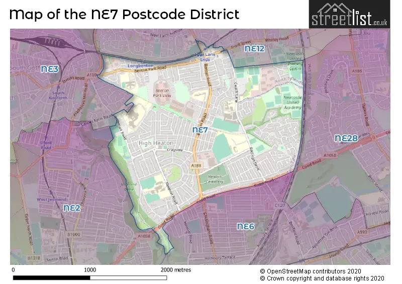
The NE7 Postcode shares a border with NE2 (NEWCASTLE UPON TYNE, Jesmond, Shieldfield), NE3 (NEWCASTLE UPON TYNE, Gosforth, South Gosforth), NE6 (NEWCASTLE UPON TYNE, Walker) and NE12 (NEWCASTLE UPON TYNE, Killingworth, Forest Hall).
In the NE7 postcode district, the primary settlement is Newcastle upon Tyne, which is located in the county of Tyne & Wear. The most significant post town in this district is also Newcastle upon Tyne. Other significant settlements include Benton, Heaton, High Heaton, and Longbenton.
For the district NE7, we have data on 1 postcode sectors. Here's a breakdown: The sector NE7 7, covers Newcastle Upon Tyne in Tyne & Wear.

Map of the NE7 Postcode District
Explore the NE7 postcode district by using our free interactive map.
When it comes to local government, postal geography often disregards political borders. However, for a breakdown in the NE7 District: the district mostly encompasses the Newcastle upon Tyne District (B) (257 postcodes), and finally, the North Tyneside District (B) area (24 postcodes).
Recent House Sales in NE70
| Date | Price | Address |
|---|---|---|
| 18/09/2023 | £130,000 | Dinningside, Belford, NE70 7NP |
| 04/08/2023 | £207,500 | High Street, Belford, NE70 7NH |
| 18/07/2023 | £225,000 | South Road, Belford, NE70 7DP |
| 30/06/2023 | £267,500 | Raynham Road, Belford, NE70 7NS |
| 21/06/2023 | £350,000 | West Street, Belford, NE70 7QD |
| 09/06/2023 | £126,000 | Dinningside, Belford, NE70 7NP |
| 16/05/2023 | £346,000 | Croft Way, Belford, NE70 7ET |
| 02/05/2023 | £115,000 | Dinningside, Belford, NE70 7NP |
| 06/04/2023 | £485,000 | Adderstone Mains, Belford, NE70 7HS |
| 10/02/2023 | £925,000 | Belford, NE70 7ED |
Weather Forecast for NE7
Press Button to Show Forecast for Longbenton
| Time Period | Icon | Description | Temperature | Rain Probability | Wind |
|---|---|---|---|---|---|
| 06:00 to 09:00 | Overcast | 6.0°C (feels like 3.0°C) | 63.00% | NNE 13 mph | |
| 09:00 to 12:00 | Heavy rain | 6.0°C (feels like 2.0°C) | 93.00% | NNW 13 mph | |
| 12:00 to 15:00 | Heavy rain | 7.0°C (feels like 3.0°C) | 92.00% | NNW 13 mph | |
| 15:00 to 18:00 | Light rain | 7.0°C (feels like 4.0°C) | 62.00% | WNW 13 mph | |
| 18:00 to 21:00 | Cloudy | 8.0°C (feels like 5.0°C) | 50.00% | W 11 mph | |
| 21:00 to 00:00 | Partly cloudy (night) | 7.0°C (feels like 4.0°C) | 5.00% | WSW 11 mph |
Press Button to Show Forecast for Longbenton
| Time Period | Icon | Description | Temperature | Rain Probability | Wind |
|---|---|---|---|---|---|
| 00:00 to 03:00 | Clear night | 6.0°C (feels like 3.0°C) | 0.00% | SW 9 mph | |
| 03:00 to 06:00 | Clear night | 6.0°C (feels like 3.0°C) | 10.00% | SSW 9 mph | |
| 06:00 to 09:00 | Cloudy | 6.0°C (feels like 3.0°C) | 37.00% | S 11 mph | |
| 09:00 to 12:00 | Cloudy | 10.0°C (feels like 7.0°C) | 6.00% | SSW 13 mph | |
| 12:00 to 15:00 | Partly cloudy (day) | 13.0°C (feels like 10.0°C) | 5.00% | SSW 13 mph | |
| 15:00 to 18:00 | Light rain shower (day) | 13.0°C (feels like 10.0°C) | 38.00% | S 13 mph | |
| 18:00 to 21:00 | Cloudy | 12.0°C (feels like 10.0°C) | 8.00% | SSE 13 mph | |
| 21:00 to 00:00 | Partly cloudy (night) | 11.0°C (feels like 8.0°C) | 1.00% | SSE 13 mph |
Press Button to Show Forecast for Longbenton
| Time Period | Icon | Description | Temperature | Rain Probability | Wind |
|---|---|---|---|---|---|
| 00:00 to 03:00 | Partly cloudy (night) | 10.0°C (feels like 7.0°C) | 1.00% | SSE 11 mph | |
| 03:00 to 06:00 | Clear night | 8.0°C (feels like 6.0°C) | 1.00% | SSE 11 mph | |
| 06:00 to 09:00 | Sunny day | 8.0°C (feels like 6.0°C) | 1.00% | SSE 9 mph | |
| 09:00 to 12:00 | Sunny day | 11.0°C (feels like 9.0°C) | 1.00% | SE 11 mph | |
| 12:00 to 15:00 | Partly cloudy (day) | 12.0°C (feels like 9.0°C) | 1.00% | ESE 13 mph | |
| 15:00 to 18:00 | Cloudy | 11.0°C (feels like 9.0°C) | 14.00% | ESE 13 mph | |
| 18:00 to 21:00 | Light rain | 10.0°C (feels like 8.0°C) | 49.00% | ESE 11 mph | |
| 21:00 to 00:00 | Light rain | 9.0°C (feels like 7.0°C) | 47.00% | E 9 mph |
Press Button to Show Forecast for Longbenton
| Time Period | Icon | Description | Temperature | Rain Probability | Wind |
|---|---|---|---|---|---|
| 00:00 to 03:00 | Overcast | 9.0°C (feels like 7.0°C) | 15.00% | ENE 7 mph | |
| 03:00 to 06:00 | Cloudy | 8.0°C (feels like 7.0°C) | 14.00% | NE 7 mph | |
| 06:00 to 09:00 | Overcast | 9.0°C (feels like 7.0°C) | 17.00% | NE 7 mph | |
| 09:00 to 12:00 | Overcast | 10.0°C (feels like 8.0°C) | 19.00% | NE 7 mph | |
| 12:00 to 15:00 | Overcast | 10.0°C (feels like 9.0°C) | 17.00% | NE 9 mph | |
| 15:00 to 18:00 | Overcast | 10.0°C (feels like 8.0°C) | 10.00% | NE 9 mph | |
| 18:00 to 21:00 | Overcast | 9.0°C (feels like 7.0°C) | 12.00% | NNE 9 mph | |
| 21:00 to 00:00 | Overcast | 9.0°C (feels like 6.0°C) | 15.00% | NNE 11 mph |
Where is the NE7 Postcode District?
The NE7 postcode district is located in the town of Newcastle upon Tyne. It is situated in close proximity to several nearby towns. To the east is Wallsend, which is approximately 2.5 miles away. To the southeast is Hebburn, which is around 3.4 miles away. Gateshead is situated to the south and is roughly 4.4 miles away. Cramlington lies to the north and is around 5.7 miles away. Lastly, Whitley Bay is located to the northeast and is approximately 5.8 miles away. The NE7 postcode district is also 248.9 miles away from the center of London.
The district is within the post town of NEWCASTLE UPON TYNE.
The sector has postcodes within the nation of England.
The NE7 Postcode District is in the Tyneside region of Northumberland and Tyne and Wear within the North East (England).
| Postcode Sector | Delivery Office |
|---|---|
| NE7 7 | Heaton Delivery Office |
| N | E | 7 | - | X | X | X |
| N | E | 7 | Space | Numeric | Letter | Letter |
Current Monthly Rental Prices
| # Bedrooms | Min Price | Max Price | Avg Price |
|---|---|---|---|
| £100 | £100 | £100 | |
| 2 | £925 | £1,600 | £1,263 |
| 3 | £1,500 | £1,500 | £1,500 |
| 4 | £3,000 | £3,000 | £3,000 |
Current House Prices
| # Bedrooms | Min Price | Max Price | Avg Price |
|---|---|---|---|
| £999,995 | £1,450,000 | £1,224,998 | |
| 1 | £110,000 | £130,000 | £123,317 |
| 2 | £130,000 | £175,000 | £150,909 |
| 3 | £120,000 | £395,000 | £258,500 |
| 4 | £320,000 | £650,000 | £414,375 |
| 5 | £310,000 | £310,000 | £310,000 |
| 6 | £200,000 | £200,000 | £200,000 |
Estate Agents who Operate in the NE7 District
| Logo | Name | Brand Name | Address | Contact Number | Total Properties |
|---|---|---|---|---|---|
 | High Heaton | Jan Forster Estates | 159 Benton Road, High Heaton, Newcastle Upon Tyne, NE7 7DU | 0191 625 0817 | 11 |
 | Newcastle Upon Tyne | Jack Harrison Estates | 162 Newton Road, High Heaton, Newcastle Upon Tyne, NE7 7HP | 0191 625 1025 | 4 |
 | covering Newcastle upon Tyne | Purplebricks | Suite 7 First Floor Cranmore Drive Shirley Solihull B90 4RZ | 020 3909 0309 | 3 |
 | North Shields | Moving Homes Sales & Lettings Limited | 2a Hawkeys Lane North Shields NE29 0JF | 0191 625 0121 | 2 |
 | Gateshead | A J P Property Services | 212 -213 Hypoint, Saltmeadows Road, Gateshead, NE8 3AH | 0191 625 0934 | 2 |
| Type of Property | 2018 Average | 2018 Sales | 2017 Average | 2017 Sales | 2016 Average | 2016 Sales | 2015 Average | 2015 Sales |
|---|---|---|---|---|---|---|---|---|
| Detached | £307,907 | 33 | £310,348 | 30 | £280,415 | 24 | £311,634 | 37 |
| Semi-Detached | £202,033 | 76 | £207,026 | 81 | £203,874 | 72 | £202,796 | 85 |
| Terraced | £195,524 | 78 | £195,884 | 103 | £195,435 | 63 | £184,236 | 64 |
| Flats | £116,419 | 62 | £117,859 | 56 | £113,067 | 52 | £119,829 | 62 |