The DL7 postcode district is a postal district located in the DL Darlington postcode area with a population of 15,669 residents according to the 2021 England and Wales Census.
The area of the DL7 postcode district is 58.21 square miles which is 150.76 square kilometres or 37,253.07 acres.
Currently, the DL7 district has about 755 postcode units spread across 3 geographic postcode sectors.
Given that each sector allows for 400 unique postcode combinations, the district has a capacity of 1,200 postcodes. With 755 postcodes already in use, this leaves 445 units available.
The largest settlement in the DL7 postal code is NORTHALLERTON followed by Leeming Bar, and Gatenby.
The DL7 Postcode shares a border with DL8 (BEDALE, LEYBURN, Askrigg), DL2 (Middleton St. George, DARLINGTON, Hurworth), DL10 (RICHMOND, Catterick, Brompton On Swale), DL6 (NORTHALLERTON, Brompton, Osmotherley) and YO7 (THIRSK, Sowerby, Carlton Miniott).
The primary settlement in the DL7 postcode district is Northallerton, located in the county of North Yorkshire in England. Other significant settlements in the district include Ainderby Steeple, Birkby, Danby Wiske, East Cowton, Great Fencote, Great Langton, Hutton Bonville, Kirkby Fleetham, Little Fencote, Little Langton, North Cowton, Pepper Arden, Romanby, Scruton, South Cowton, Streetlam, Thrintoft, and Yafforth. The most significant post town in the district is Northallerton.
For the district DL7, we have data on 4 postcode sectors. Here's a breakdown: The sector DL7 0, covers East Cowton and Danby Wiske and Kirkby Fleetham and North Cowton and Scruton in North Yorkshire. The sector DL7 7 is non-geographic. It's often designated for PO Boxes, large organisations, or special services. The sector DL7 8, covers Northallerton in North Yorkshire. The sector DL7 9, covers Leeming Bar and Morton On Swale and Leeming in North Yorkshire.

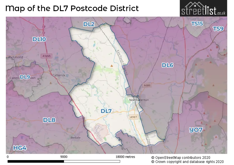
Map of the DL7 Postcode District
Explore the DL7 postcode district by using our free interactive map.
When it comes to local government, postal geography often disregards political borders. However, for a breakdown in the DL7 District: the district mostly encompasses the North Yorkshire area with a total of 755 postcodes.
Weather Forecast for DL7
Press Button to Show Forecast for Ainderby Steeple Primary School
| Time Period | Icon | Description | Temperature | Rain Probability | Wind |
|---|---|---|---|---|---|
| 09:00 to 12:00 | Cloudy | 8.0°C (feels like 6.0°C) | 11.00% | NE 7 mph | |
| 12:00 to 15:00 | Overcast | 9.0°C (feels like 7.0°C) | 13.00% | NE 9 mph | |
| 15:00 to 18:00 | Overcast | 9.0°C (feels like 6.0°C) | 16.00% | NE 9 mph | |
| 18:00 to 21:00 | Cloudy | 8.0°C (feels like 6.0°C) | 49.00% | NNE 7 mph | |
| 21:00 to 00:00 | Cloudy | 5.0°C (feels like 3.0°C) | 6.00% | NNE 4 mph |
Press Button to Show Forecast for Ainderby Steeple Primary School
| Time Period | Icon | Description | Temperature | Rain Probability | Wind |
|---|---|---|---|---|---|
| 00:00 to 03:00 | Cloudy | 4.0°C (feels like 2.0°C) | 5.00% | N 7 mph | |
| 03:00 to 06:00 | Cloudy | 5.0°C (feels like 2.0°C) | 10.00% | N 9 mph | |
| 06:00 to 09:00 | Overcast | 6.0°C (feels like 3.0°C) | 20.00% | N 11 mph | |
| 09:00 to 12:00 | Light rain | 7.0°C (feels like 4.0°C) | 51.00% | N 13 mph | |
| 12:00 to 15:00 | Light rain | 8.0°C (feels like 5.0°C) | 51.00% | NNW 13 mph | |
| 15:00 to 18:00 | Light rain | 10.0°C (feels like 7.0°C) | 44.00% | NW 11 mph | |
| 18:00 to 21:00 | Partly cloudy (day) | 10.0°C (feels like 8.0°C) | 8.00% | WSW 7 mph | |
| 21:00 to 00:00 | Partly cloudy (night) | 7.0°C (feels like 4.0°C) | 2.00% | SW 7 mph |
Press Button to Show Forecast for Ainderby Steeple Primary School
| Time Period | Icon | Description | Temperature | Rain Probability | Wind |
|---|---|---|---|---|---|
| 00:00 to 03:00 | Clear night | 5.0°C (feels like 2.0°C) | 1.00% | SW 7 mph | |
| 03:00 to 06:00 | Clear night | 4.0°C (feels like 2.0°C) | 1.00% | SSW 7 mph | |
| 06:00 to 09:00 | Sunny day | 5.0°C (feels like 3.0°C) | 1.00% | S 7 mph | |
| 09:00 to 12:00 | Sunny day | 10.0°C (feels like 8.0°C) | 1.00% | S 11 mph | |
| 12:00 to 15:00 | Cloudy | 13.0°C (feels like 10.0°C) | 6.00% | S 13 mph | |
| 15:00 to 18:00 | Cloudy | 14.0°C (feels like 11.0°C) | 7.00% | S 16 mph | |
| 18:00 to 21:00 | Cloudy | 13.0°C (feels like 11.0°C) | 7.00% | SSE 11 mph | |
| 21:00 to 00:00 | Partly cloudy (night) | 10.0°C (feels like 7.0°C) | 4.00% | SE 9 mph |
Press Button to Show Forecast for Ainderby Steeple Primary School
| Time Period | Icon | Description | Temperature | Rain Probability | Wind |
|---|---|---|---|---|---|
| 00:00 to 03:00 | Clear night | 8.0°C (feels like 6.0°C) | 2.00% | SE 9 mph | |
| 03:00 to 06:00 | Clear night | 6.0°C (feels like 3.0°C) | 3.00% | SE 7 mph | |
| 06:00 to 09:00 | Partly cloudy (day) | 7.0°C (feels like 5.0°C) | 3.00% | ESE 7 mph | |
| 09:00 to 12:00 | Partly cloudy (day) | 12.0°C (feels like 11.0°C) | 9.00% | ESE 7 mph | |
| 12:00 to 15:00 | Cloudy | 15.0°C (feels like 13.0°C) | 13.00% | ESE 11 mph | |
| 15:00 to 18:00 | Light rain shower (day) | 15.0°C (feels like 13.0°C) | 33.00% | E 13 mph | |
| 18:00 to 21:00 | Partly cloudy (day) | 14.0°C (feels like 12.0°C) | 5.00% | E 11 mph | |
| 21:00 to 00:00 | Cloudy | 10.0°C (feels like 8.0°C) | 10.00% | ENE 7 mph |
Where is the DL7 Postcode District?
The postcode district DL7 is located in Northallerton. It is a town situated in close proximity to several nearby towns. To the South West, there is Bedale which is approximately 6.6 miles away. Catterick Garrison is located to the West, around 8.6 miles away. Darlington is situated to the North, at a distance of about 11.3 miles. Yarm is located to the North East, roughly 12.2 miles away. Thirsk is situated to the South East, approximately 12.3 miles away. Ripon is located to the South, at a distance of around 15.5 miles. Furthermore, Northallerton is located about 205.1 miles away from the center of London.
The district covers the post towns of BEDALE, NORTHALLERTON.
The sector has postcodes within the nation of England.
The DL7 Postcode District is in the North Yorkshire CC region of North Yorkshire within the Yorkshire and The Humber.
| Postcode Sector | Delivery Office |
|---|---|
| DL7 0 | Northallerton Delivery Office |
| DL7 8 | Northallerton Delivery Office |
| DL7 9 | Northallerton Delivery Office |
| D | L | 7 | - | X | X | X |
| D | L | 7 | Space | Numeric | Letter | Letter |
Current Monthly Rental Prices
| # Bedrooms | Min Price | Max Price | Avg Price |
|---|---|---|---|
| 1 | £750 | £750 | £750 |
| 2 | £725 | £1,500 | £1,113 |
| 3 | £825 | £1,950 | £1,150 |
| 4 | £1,150 | £2,950 | £2,050 |
Current House Prices
| # Bedrooms | Min Price | Max Price | Avg Price |
|---|---|---|---|
| £30,000 | £325,000 | £218,333 | |
| 1 | £125,000 | £140,000 | £130,500 |
| 2 | £69,999 | £745,000 | £191,112 |
| 3 | £190,000 | £650,000 | £308,990 |
| 4 | £210,000 | £2,280,000 | £473,394 |
| 5 | £280,000 | £1,950,000 | £644,333 |
| 6 | £575,000 | £1,000,000 | £787,500 |
| 9 | £4,000,000 | £4,000,000 | £4,000,000 |
Estate Agents who Operate in the DL7 District
| Logo | Name | Brand Name | Address | Contact Number | Total Properties |
|---|---|---|---|---|---|
 | Northallerton | Youngs RPS | 80-81 High Street, Northallerton, DL7 8EG | 01609 716678 | 22 |
 | Northallerton | Carver Residential | 219 High Street Northallerton DL7 8LW | 01609 716683 | 17 |
 | Northallerton | James Winn Estate Agents | 231 High Street, Northallerton, DL7 8EG | 01609 716835 | 17 |
 | Northallerton | Bridgfords | 75-76 High Street Northallerton DL7 8EG | 01609 716852 | 12 |
 | Northallerton | Northallerton Estate Agency | 143 High Street, Northallerton, DL7 8PE | 01609 716730 | 9 |
| Type of Property | 2018 Average | 2018 Sales | 2017 Average | 2017 Sales | 2016 Average | 2016 Sales | 2015 Average | 2015 Sales |
|---|---|---|---|---|---|---|---|---|
| Detached | £310,304 | 112 | £293,106 | 130 | £280,587 | 115 | £288,107 | 127 |
| Semi-Detached | £222,302 | 77 | £200,552 | 98 | £186,761 | 92 | £201,448 | 92 |
| Terraced | £180,651 | 66 | £193,548 | 67 | £172,984 | 78 | £160,364 | 78 |
| Flats | £122,850 | 30 | £134,838 | 20 | £146,408 | 20 | £148,611 | 17 |