The DL11 postcode district is a postal district located in the DL Darlington postcode area with a population of 4,847 residents according to the 2021 England and Wales Census.
The area of the DL11 postcode district is 198.97 square miles which is 515.33 square kilometres or 127,339.54 acres.
Currently, the DL11 district has about 452 postcode units spread across 2 geographic postcode sectors.
Given that each sector allows for 400 unique postcode combinations, the district has a capacity of 800 postcodes. With 452 postcodes already in use, this leaves 348 units available.
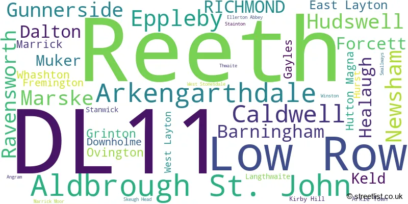
The largest settlement in the DL11 postal code is Hurst followed by Reeth, and Low Row.
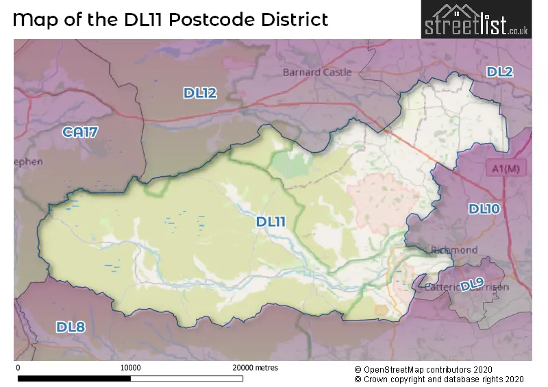
The DL11 Postcode shares a border with DL8 (BEDALE, LEYBURN, Askrigg), DL2 (Middleton St. George, DARLINGTON, Hurworth), DL10 (RICHMOND, Catterick, Brompton On Swale), DL12 (BARNARD CASTLE, Middleton-in-Teesdale, Eggleston), DL9 (CATTERICK GARRISON, Colburn, Scotton) and CA17 (KIRKBY STEPHEN, Brough, Ravenstonedale).
In the DL11 postcode district, the primary settlement is Richmond, which is located in the county of North Yorkshire, England. Other significant settlements in this district include Arkengarthdale, Downholme, Fremington, Grinton, Gunnerside, Healaugh, Hudswell, Keld, Langthwaite, Low Row, Muker, Reeth, Aldbrough St. John, Barningham, Caldwell, Dalton, East Layton, Eppleby, Forcett, Gayles, Hutton Magna, Kirby Hill, Marrick, Marske, Newsham, Ravensworth, Stanwick, West Layton, and Whashton. The most significant post town in DL11 is Richmond.
For the district DL11, we have data on 2 postcode sectors. Here's a breakdown: The sector DL11 6, covers Reeth and Low Row and Arkengarthdale in North Yorkshire. The sector DL11 7, covers Aldbrough St. John in North Yorkshire.

Map of the DL11 Postcode District
Explore the DL11 postcode district by using our free interactive map.
When it comes to local government, postal geography often disregards political borders. However, for a breakdown in the DL11 District: the district mostly encompasses the North Yorkshire (421 postcodes), and finally, the County Durham area (33 postcodes).
Weather Forecast for DL11
Press Button to Show Forecast for Fremington
| Time Period | Icon | Description | Temperature | Rain Probability | Wind |
|---|---|---|---|---|---|
| 09:00 to 12:00 | Cloudy | 7.0°C (feels like 5.0°C) | 7.00% | ENE 7 mph | |
| 12:00 to 15:00 | Overcast | 8.0°C (feels like 6.0°C) | 11.00% | ENE 9 mph | |
| 15:00 to 18:00 | Overcast | 8.0°C (feels like 5.0°C) | 48.00% | ENE 9 mph | |
| 18:00 to 21:00 | Light rain | 6.0°C (feels like 4.0°C) | 47.00% | ENE 9 mph | |
| 21:00 to 00:00 | Cloudy | 4.0°C (feels like 2.0°C) | 8.00% | NE 4 mph |
Press Button to Show Forecast for Fremington
| Time Period | Icon | Description | Temperature | Rain Probability | Wind |
|---|---|---|---|---|---|
| 00:00 to 03:00 | Cloudy | 4.0°C (feels like 1.0°C) | 5.00% | NNE 7 mph | |
| 03:00 to 06:00 | Cloudy | 4.0°C (feels like 1.0°C) | 11.00% | N 7 mph | |
| 06:00 to 09:00 | Cloudy | 5.0°C (feels like 2.0°C) | 10.00% | N 9 mph | |
| 09:00 to 12:00 | Light rain | 6.0°C (feels like 3.0°C) | 48.00% | N 13 mph | |
| 12:00 to 15:00 | Light rain | 7.0°C (feels like 4.0°C) | 49.00% | NNW 11 mph | |
| 15:00 to 18:00 | Light rain | 9.0°C (feels like 6.0°C) | 45.00% | NW 11 mph | |
| 18:00 to 21:00 | Partly cloudy (day) | 9.0°C (feels like 7.0°C) | 7.00% | WNW 9 mph | |
| 21:00 to 00:00 | Clear night | 5.0°C (feels like 3.0°C) | 1.00% | SW 9 mph |
Press Button to Show Forecast for Fremington
| Time Period | Icon | Description | Temperature | Rain Probability | Wind |
|---|---|---|---|---|---|
| 00:00 to 03:00 | Clear night | 4.0°C (feels like 2.0°C) | 1.00% | SW 7 mph | |
| 03:00 to 06:00 | Clear night | 4.0°C (feels like 1.0°C) | 1.00% | SSW 7 mph | |
| 06:00 to 09:00 | Sunny day | 5.0°C (feels like 3.0°C) | 2.00% | S 7 mph | |
| 09:00 to 12:00 | Cloudy | 10.0°C (feels like 7.0°C) | 6.00% | S 13 mph | |
| 12:00 to 15:00 | Cloudy | 12.0°C (feels like 9.0°C) | 7.00% | S 13 mph | |
| 15:00 to 18:00 | Cloudy | 12.0°C (feels like 10.0°C) | 9.00% | S 13 mph | |
| 18:00 to 21:00 | Partly cloudy (day) | 11.0°C (feels like 9.0°C) | 6.00% | S 11 mph | |
| 21:00 to 00:00 | Partly cloudy (night) | 9.0°C (feels like 6.0°C) | 5.00% | SSE 9 mph |
Press Button to Show Forecast for Fremington
| Time Period | Icon | Description | Temperature | Rain Probability | Wind |
|---|---|---|---|---|---|
| 00:00 to 03:00 | Clear night | 7.0°C (feels like 5.0°C) | 2.00% | SSE 9 mph | |
| 03:00 to 06:00 | Partly cloudy (night) | 6.0°C (feels like 3.0°C) | 3.00% | SSE 7 mph | |
| 06:00 to 09:00 | Partly cloudy (day) | 7.0°C (feels like 5.0°C) | 4.00% | ESE 7 mph | |
| 09:00 to 12:00 | Cloudy | 10.0°C (feels like 8.0°C) | 8.00% | ESE 9 mph | |
| 12:00 to 15:00 | Cloudy | 14.0°C (feels like 11.0°C) | 14.00% | ESE 11 mph | |
| 15:00 to 18:00 | Cloudy | 13.0°C (feels like 11.0°C) | 11.00% | E 11 mph | |
| 18:00 to 21:00 | Cloudy | 12.0°C (feels like 10.0°C) | 10.00% | E 9 mph | |
| 21:00 to 00:00 | Overcast | 9.0°C (feels like 8.0°C) | 12.00% | ENE 7 mph |
Where is the DL11 Postcode District?
The postcode district DL11 is located in Richmond, which is a town in the district. Richmond is situated near several other towns, including Barnard Castle to the north, Leyburn to the southeast, Catterick Garrison to the east, Hawes to the southwest, Kirkby Stephen to the west, and Shildon to the northeast. Additionally, the distance between Richmond and London is approximately 216.06 miles.
The district is within the post town of RICHMOND.
The sector has postcodes within the nation of England.
The DL11 Postcode District is covers the following regions.
- North Yorkshire CC - North Yorkshire - Yorkshire and The Humber
- Durham CC - Tees Valley and Durham - North East (England)
| Postcode Sector | Delivery Office |
|---|---|
| DL11 6 | Richmond (dl) Delivery Office |
| DL11 7 | Richmond (dl) Delivery Office |
| D | L | 1 | 1 | - | X | X | X |
| D | L | 1 | 1 | Space | Numeric | Letter | Letter |
Current Monthly Rental Prices
| # Bedrooms | Min Price | Max Price | Avg Price |
|---|---|---|---|
| 2 | £750 | £750 | £750 |
| 4 | £1,300 | £1,300 | £1,300 |
Current House Prices
| # Bedrooms | Min Price | Max Price | Avg Price |
|---|---|---|---|
| £54,000 | £500,000 | £254,800 | |
| 1 | £195,000 | £385,000 | £301,667 |
| 2 | £150,000 | £425,995 | £268,396 |
| 3 | £265,000 | £625,995 | £409,326 |
| 4 | £285,000 | £685,000 | £455,829 |
| 5 | £450,000 | £700,000 | £631,238 |
| 6 | £695,000 | £750,000 | £726,667 |
| 52 | £11,000,000 | £11,000,000 | £11,000,000 |
Estate Agents who Operate in the DL11 District
| Logo | Name | Brand Name | Address | Contact Number | Total Properties |
|---|---|---|---|---|---|
 | Richmond | Alderson Estate Agents | 7 King Street, Richmond, North Yorkshire DL10 4HP | 01748 822711 | 15 |
 | Richmond | Charltons Chartered Surveyors & Estate Agents | 27A Market Place, Richmond, DL10 4QG | 01748 901932 | 9 |
 | Leyburn | GSC Grays | 15 High Street, Leyburn, DL8 5AQ | 01969 608811 | 6 |
 | Leyburn | J.R Hopper & Co | Central Chambers Market Place, Leyburn, DL8 5BD | 01969 600599 | 6 |
 | Richmond | Norman F. Brown | 14 Queens Road, Richmond, DL10 4AG | 01748 901928 | 5 |
- Aldbrough St John
- Angram
- Barningham
- Barton
- Bellerby
- Caldwell
- Catterick Garrison
- Cliffe
- Dalton
- East Layton
- Eppleby
- Feetham
- Forcett
- Gainford
- Gayles
- Greta Bridge
- Grinton
- Gunnerside
- Healaugh
- Hudswell
- Hutton Magna
- Kearton
- Keld
- Kirby Hill
- Langthwaite
- Low Row
- Manfield
- Marske
- Muker
- Newsham
- Ovington
- Ravensworth
- Reeth
- Richmond
- Scargill
- Thwaite
- Thwaite
- Whashton
- Winston
| Type of Property | 2018 Average | 2018 Sales | 2017 Average | 2017 Sales | 2016 Average | 2016 Sales | 2015 Average | 2015 Sales |
|---|---|---|---|---|---|---|---|---|
| Detached | £374,628 | 43 | £369,338 | 37 | £327,203 | 37 | £344,666 | 21 |
| Semi-Detached | £253,084 | 19 | £259,208 | 19 | £244,762 | 17 | £239,608 | 22 |
| Terraced | £212,714 | 26 | £201,602 | 27 | £235,073 | 31 | £214,263 | 34 |
| Flats | £188,500 | 1 | £99,250 | 2 | £150,000 | 1 | £0 | 0 |