This section of the site is all about the LA Postcode area, also known as the Lancaster Postal Area. Explore links to the next level to learn more about specific postcode districts such as LA1.
The LA postcode area represents a group of postal districts in the Lancaster area of the United Kingdom. The area code LA stands for the letters l and a in LAcaster. LA has a population of 328,704 and covers an area of 2,703,149 hectares. Fun fact: 0.51% of the population of Great Britain lives in this area.
The postcode area falls within the following counties: Cumbria (59.93%), Lancashire (36.67%), North Yorkshire (3.40%).
Post Towns and Postcode Districts for the LA Postcode
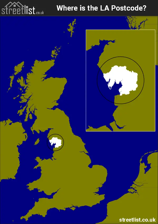
Where is the LA Postcode Area?
The LA Lancaster Postcode is in the North West of England. The postal area borders the following neighbouring postal areas: PR - Preston, CA - Carlisle, BB - Blackburn, BD - Bradford and DL - Darlington, It also borders The Irish Sea and Morecambe Bay.
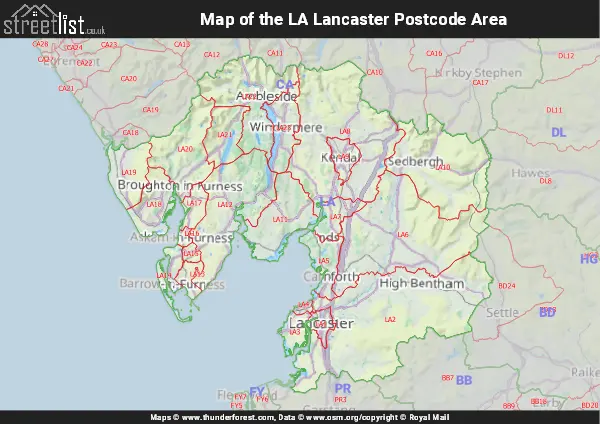
Map of the LA Lancaster Postcode Area
Explore the LA Lancaster postcode area by using our interactive map.
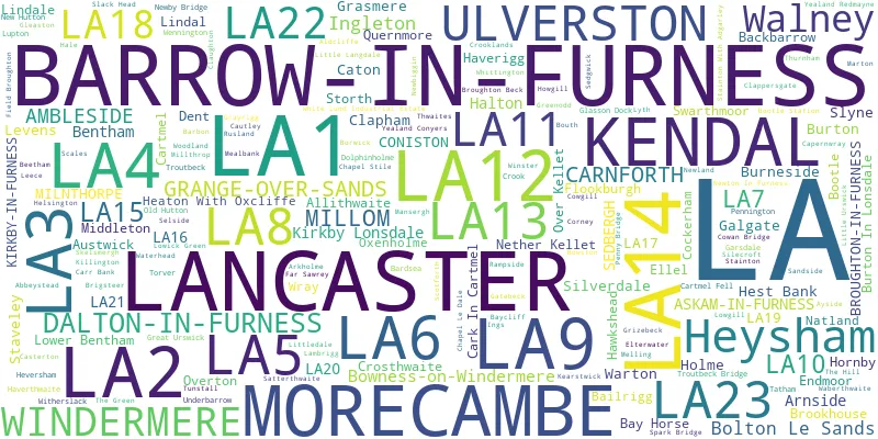
Postcode Districts within the LA Lancaster Postcode Area
There are 23 postcode districts within the Lancaster postcode area
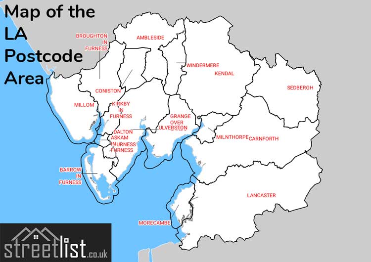
A map showing the boundary of in relation to other areas
There are 16 towns within the Lancaster postcode area.
| Unit | Area² |
|---|---|
| Hectares | 2,703,149² |
| Miles | 10,437² |
| Feet | 290,964,255,211² |
| Kilometres | 27,031² |
Postal Delivery Offices serving the LA Lancaster Postcode Area
- Austwick Scale Payment Delivery Office
- Barrow In Furness Delivery Office
- Bentham Scale Payment Delivery Office
- Broughton-in-furness Scale Payment Delivery Office
- Carnforth Delivery Office
- Grange Over Sands Delivery Office
- Ingleton Scale Payment Delivery Office
- Kendal Delivery Office
- Kirkby Lonsdale Scale Payment Delivery Office
- Lancaster Delivery Office
- Levens Scale Payment Delivery Office
- Millom Delivery Office
- Milnthorpe Scale Payment Delivery Office
- Morecambe Delivery Office
- Sedbergh Scale Payment Delivery Office
- Ulverston Delivery Office
- Windermere Delivery Office
- Wray Scale Payment Delivery Office
Councils with Postcodes in LA
Towns and Villages within the LA Lancaster Postcode Area
- Ackenthwaite - village
- Aldcliffe - village
- Allithwaite - village
- Ambleside - town
- Arkholme - village
- Arnside - village
- Askam in Furness - village
- Austwick - village
- Ayside - village
- Backbarrow - village
- Barbon - village
- Bardsea - village
- Barrow-in-Furness - town
- Barrows Green - village
- Bay Horse - village
- Baycliff - village
- Beetham - village
- Bolton-le-Sands - village
- Bootle - village
- Borwick - village
- Bouth - village
- Bowmanstead - village
- Bowness-on-Windermere - town
- Bowston - village
- Brigsteer - village
- Broughton Beck - village
- Broughton in Furness - town
- Broughton Mills - otherSettlement
- Burneside - village
- Burton in Lonsdale - village
- Burton-in-Kendal - village
- Capernwray - village
- Cark - village
- Carnforth - town
- Carr Bank - village
- Cartmel - village
- Casterton - village
- Caton - village
- Cautley - otherSettlement
- Chapel Stile - village
- Chapel-le-Dale - otherSettlement
- Clapham - village
- Clappersgate - village
- Claughton - village
- Cockerham - village
- Coniston - village
- Corney - otherSettlement
- Cowan Head - village
- Cowgill - village
- Crook - village
- Crosthwaite - village
- Dalton-in-Furness - town
- Dent - village
- Dolphinholme - village
- Ellel - village
- Elterwater - village
- Endmoor - village
- Far Sawrey - village
- Field Broughton - village
- Finsthwaite - village
- Flookburgh - village
- Foxfield - village
- Galgate - village
- Garsdale - village
- Gatebeck - village
- Ghyll Head - village
- Glasson - village
- Gleaston - village
- Grange-over-Sands - town
- Grasmere - village
- Great Urswick - village
- Greenodd - village
- Grizebeck - village
- Hale - village
- Halton - village
- Haverigg - village
- Haverthwaite - village
- Hawkshead - village
- Hest Bank - village
- Heversham - village
- Heysham - town
- High Bentham - town
- Holker - village
- Holme - village
- Hornby - village
- Hutton Roof - village
- Ingleton - village
- Ings - village
- Kendal - town
- Kirkby Lonsdale - town
- Kirkby-in-Furness - village
- Kirksanton - village
- Lakeside - village
- Lancaster - city
- Leasgill - village
- Leck - village
- Leece - village
- Levens - village
- Lindal in Furness - village
- Lindale - village
- Little Langdale - village
- Little Loughrigg - otherSettlement
- Little Urswick - village
- Low Bentham - village
- Lowick Bridge - village
- Lowick Green - village
- Lupton - village
- Marthwaite - otherSettlement
- Marton - village
- Meal Bank - village
- Meathop - village
- Melling - village
- Middleton - village
- Middleton - otherSettlement
- Millom - town
- Millthrop - village
- Milnthorpe - village
- Morecambe - town
- Natland - village
- Near Sawrey - village
- Nether Burrow - village
- Nether Kellet - village
- Newbiggin - village
- Newby - village
- Newby Bridge - village
- Newton - village
- Newton-in-Cartmel - village
- Over Kellet - village
- Overton - village
- Oxenholme - village
- Pennington - village
- Penny Bridge - village
- Potters Brook - village
- Preston Patrick - otherSettlement
- Priest Hutton - village
- Quernmore - otherSettlement
- Quernmore - village
- Rampside - village
- Ravenstown - village
- Roa Island - village
- Roosebeck - village
- Rosside - village
- Rydal - village
- Sandside - village
- Satterthwaite - village
- Scales - village
- Sedbergh - town
- Sedgwick - village
- Silecroft - village
- Silverdale - village
- Slack Head - village
- Slyne - village
- Soutergate - village
- Spark Bridge - village
- Stainton - village
- Stainton with Adgarley - village
- Staveley - village
- Staveley-in-Cartmel - village
- Storrs - village
- Storth - village
- Summerlands - village
- Sunderland - village
- Swarthmoor - village
- Tewitfield - village
- The Green - village
- The Hill - village
- The Row - village
- Torver - village
- Tower Wood - village
- Town End - village
- Troutbeck - village
- Tunstall - village
- Ulverston - town
- Underbarrow - village
- Warton - village
- Wennington - village
- Whittington - village
- Windermere - town
- Winster - village
- Witherslack - village
- Wray - village
- Yealand Conyers - village
- Yealand Redmayne - village