The LA15 postcode district is a postal district located in the LA Lancaster postcode area with a population of 7,655 residents according to the 2021 England and Wales Census.
The area of the LA15 postcode district is 3.87 square miles which is 10.03 square kilometres or 2,477.58 acres.
Currently, the LA15 district has about 260 postcode units spread across 1 geographic postcode sectors.
Given that each sector allows for 400 unique postcode combinations, the district has a capacity of 400 postcodes. With 260 postcodes already in use, this leaves 140 units available.
The LA15 postal code covers the settlement of DALTON-IN-FURNESS.
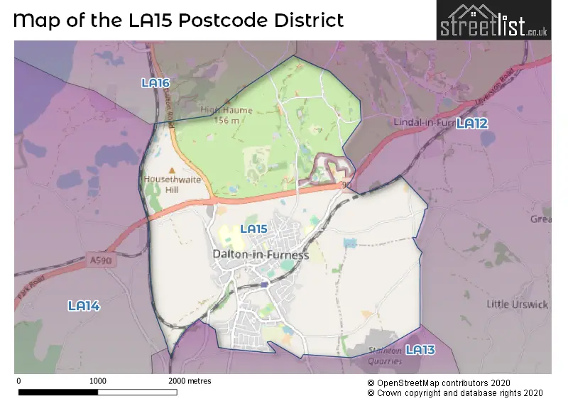
The LA15 Postcode shares a border with LA13 (BARROW-IN-FURNESS, Newton In Furness, Stainton With Adgarley).
The primary settlement in the LA15 postcode district is Dalton-in-Furness, which is located in the county of Cumbria, England.
For the district LA15, we have data on 1 postcode sectors. Here's a breakdown: The sector LA15 8, covers Dalton-In-Furness in Cumbria.
LA15 Postcode Sectors

Map of the LA15 Postcode District
Explore the LA15 postcode district by using our free interactive map.
When it comes to local government, postal geography often disregards political borders. However, for a breakdown in the LA15 District: the district mostly encompasses the Westmorland and Furness area with a total of 262 postcodes.
Recent House Sales in LA15
| Date | Price | Address |
|---|---|---|
| 29/09/2023 | £60,000 | Ulverston Road, Dalton-in-furness, LA15 8EF |
| 11/09/2023 | £118,000 | Cobden Street, Dalton-in-furness, LA15 8SE |
| 08/09/2023 | £155,000 | Bowness Road, Dalton-in-furness, LA15 8NJ |
| 08/09/2023 | £220,000 | Crompton Drive, Dalton-in-furness, LA15 8ND |
| 05/09/2023 | £325,000 | Beckside Road, Dalton-in-furness, LA15 8DP |
| 01/09/2023 | £185,000 | Pennington Close, Dalton-in-furness, LA15 8PF |
| 22/08/2023 | £75,000 | Eskdale Drive, Dalton-in-furness, LA15 8NX |
| 21/08/2023 | £105,000 | Crooklands Brow, Dalton-in-furness, LA15 8HB |
| 16/08/2023 | £165,000 | William Close, Dalton-in-furness, LA15 8JD |
| 16/08/2023 | £110,000 | Lancaster Street, Dalton-in-furness, LA15 8SD |
Weather Forecast for LA15
Press Button to Show Forecast for Dalton-In-Furness
| Time Period | Icon | Description | Temperature | Rain Probability | Wind |
|---|---|---|---|---|---|
| 00:00 to 03:00 | Cloudy | 5.0°C (feels like 2.0°C) | 4.00% | ENE 7 mph | |
| 03:00 to 06:00 | Clear night | 4.0°C (feels like 1.0°C) | 1.00% | ENE 7 mph | |
| 06:00 to 09:00 | Partly cloudy (day) | 4.0°C (feels like 2.0°C) | 0.00% | NE 7 mph | |
| 09:00 to 12:00 | Sunny day | 8.0°C (feels like 6.0°C) | 1.00% | E 7 mph | |
| 12:00 to 15:00 | Overcast | 11.0°C (feels like 10.0°C) | 9.00% | E 4 mph | |
| 15:00 to 18:00 | Cloudy | 11.0°C (feels like 10.0°C) | 10.00% | NNW 4 mph | |
| 18:00 to 21:00 | Light rain | 9.0°C (feels like 7.0°C) | 47.00% | E 7 mph | |
| 21:00 to 00:00 | Partly cloudy (night) | 7.0°C (feels like 4.0°C) | 1.00% | ENE 7 mph |
Press Button to Show Forecast for Dalton-In-Furness
| Time Period | Icon | Description | Temperature | Rain Probability | Wind |
|---|---|---|---|---|---|
| 00:00 to 03:00 | Partly cloudy (night) | 5.0°C (feels like 2.0°C) | 1.00% | NE 7 mph | |
| 03:00 to 06:00 | Cloudy | 4.0°C (feels like 2.0°C) | 4.00% | NNE 7 mph | |
| 06:00 to 09:00 | Partly cloudy (day) | 5.0°C (feels like 3.0°C) | 2.00% | N 7 mph | |
| 09:00 to 12:00 | Cloudy | 9.0°C (feels like 7.0°C) | 6.00% | N 9 mph | |
| 12:00 to 15:00 | Overcast | 11.0°C (feels like 8.0°C) | 11.00% | NW 11 mph | |
| 15:00 to 18:00 | Sunny day | 10.0°C (feels like 8.0°C) | 4.00% | WNW 13 mph | |
| 18:00 to 21:00 | Sunny day | 10.0°C (feels like 7.0°C) | 1.00% | W 11 mph | |
| 21:00 to 00:00 | Clear night | 8.0°C (feels like 5.0°C) | 2.00% | WSW 11 mph |
Press Button to Show Forecast for Dalton-In-Furness
| Time Period | Icon | Description | Temperature | Rain Probability | Wind |
|---|---|---|---|---|---|
| 00:00 to 03:00 | Cloudy | 8.0°C (feels like 5.0°C) | 7.00% | SW 11 mph | |
| 03:00 to 06:00 | Cloudy | 8.0°C (feels like 5.0°C) | 11.00% | SSW 11 mph | |
| 06:00 to 09:00 | Light rain shower (day) | 8.0°C (feels like 5.0°C) | 35.00% | SSE 13 mph | |
| 09:00 to 12:00 | Light rain shower (day) | 10.0°C (feels like 7.0°C) | 34.00% | SSE 16 mph | |
| 12:00 to 15:00 | Light rain shower (day) | 12.0°C (feels like 9.0°C) | 34.00% | S 16 mph | |
| 15:00 to 18:00 | Partly cloudy (day) | 13.0°C (feels like 10.0°C) | 13.00% | S 16 mph | |
| 18:00 to 21:00 | Cloudy | 12.0°C (feels like 9.0°C) | 17.00% | SSE 13 mph | |
| 21:00 to 00:00 | Cloudy | 11.0°C (feels like 8.0°C) | 16.00% | SSE 13 mph |
Press Button to Show Forecast for Dalton-In-Furness
| Time Period | Icon | Description | Temperature | Rain Probability | Wind |
|---|---|---|---|---|---|
| 00:00 to 03:00 | Partly cloudy (night) | 10.0°C (feels like 7.0°C) | 11.00% | SE 13 mph | |
| 03:00 to 06:00 | Partly cloudy (night) | 9.0°C (feels like 6.0°C) | 12.00% | SE 13 mph | |
| 06:00 to 09:00 | Cloudy | 9.0°C (feels like 6.0°C) | 12.00% | ESE 13 mph | |
| 09:00 to 12:00 | Partly cloudy (day) | 12.0°C (feels like 9.0°C) | 5.00% | ESE 13 mph | |
| 12:00 to 15:00 | Partly cloudy (day) | 15.0°C (feels like 12.0°C) | 8.00% | SE 16 mph | |
| 15:00 to 18:00 | Cloudy | 16.0°C (feels like 13.0°C) | 12.00% | SE 13 mph | |
| 18:00 to 21:00 | Sunny day | 14.0°C (feels like 12.0°C) | 7.00% | ESE 11 mph | |
| 21:00 to 00:00 | Cloudy | 12.0°C (feels like 10.0°C) | 7.00% | ENE 9 mph |
Where is the LA15 Postcode District?
The postcode district LA15 is located in Dalton-in-Furness. Located nearby are several towns: Askam-in-Furness to the North West (1.72 miles away), Barrow-in-Furness to the South West (3.02 miles away), Kirkby-in-Furness to the North (4.97 miles away), Ulverston to the North East (5.52 miles away), Grange-over-Sands to the East (11.03 miles away), and Morecambe to the South East (14.76 miles away). Additionally, Dalton-in-Furness is approximately 223.41 miles away from London.
The district is within the post town of DALTON-IN-FURNESS.
The sector has postcodes within the nation of England.
The LA15 Postcode District is covers the following regions.
- West Cumbria - Cumbria - North West (England)
- East Cumbria - Cumbria - North West (England)
Postcode Sectors within the LA15 District
Postcode Districts that Share a Border with LA15
| Postcode Sector | Delivery Office |
|---|---|
| LA15 8 | Barrow In Furness Delivery Office |
| L | A | 1 | 5 | - | X | X | X |
| L | A | 1 | 5 | Space | Numeric | Letter | Letter |
Current Monthly Rental Prices
| # Bedrooms | Min Price | Max Price | Avg Price |
|---|---|---|---|
| 2 | £625 | £725 | £675 |
| 3 | £1,100 | £1,100 | £1,100 |
Current House Prices
| # Bedrooms | Min Price | Max Price | Avg Price |
|---|---|---|---|
| £120,000 | £150,000 | £130,000 | |
| 2 | £50,000 | £215,000 | £125,665 |
| 3 | £70,000 | £595,000 | £219,337 |
| 4 | £115,000 | £650,000 | £337,483 |
| 5 | £245,000 | £325,000 | £285,000 |
Estate Agents who Operate in the LA15 District
| Logo | Name | Brand Name | Address | Contact Number | Total Properties |
|---|---|---|---|---|---|
 | Barrow In Furness | Corrie and Co Ltd | 129 - 130, Ramsden Square Barrow-In-Furness LA14 1XA | 01229 444802 | 13 |
 | Ulverston | J H Homes | 2 New Market Street, Ulverston, LA12 7LN | 01229 445004 | 12 |
 | Barrow-in-Furness | Poole Townsend | 69-75 Duke Street Barrow-In-Furness LA14 1RT | 01229 441887 | 8 |
 | Barrow In Furness | Ross Estate Agencies | 16-18 Cavendish Street, Barrow-In-Furness, LA14 1SB | 01229 441889 | 8 |
 | North West | Yopa | Meridian House Wheatfield Way Hinckley LE10 1YG | 0121 387 6828 | 8 |
| Type of Property | 2018 Average | 2018 Sales | 2017 Average | 2017 Sales | 2016 Average | 2016 Sales | 2015 Average | 2015 Sales |
|---|---|---|---|---|---|---|---|---|
| Detached | £236,954 | 13 | £239,214 | 14 | £221,989 | 9 | £197,638 | 20 |
| Semi-Detached | £159,600 | 30 | £177,826 | 39 | £156,458 | 36 | £149,340 | 41 |
| Terraced | £105,648 | 106 | £104,597 | 94 | £103,005 | 95 | £98,698 | 94 |
| Flats | £54,333 | 3 | £118,333 | 3 | £63,583 | 6 | £73,500 | 2 |