This section of the site is all about the DN Postcode area, also known as the Doncaster Postal Area. Explore links to the next level to learn more about specific postcode districts such as DN1.
The DN postcode area represents a group of postal districts in the Doncaster area of the United Kingdom. The area code DN stands for the letters d and n in DoNcaster. DN has a population of 755,713 and covers an area of 2,812,196 hectares. Fun fact: 1.16% of the population of Great Britain lives in this area.
The postcode area falls within the following counties: Lincolnshire (49.77%), South Yorkshire (35.13%), Nottinghamshire (7.92%), East Riding of Yorkshire (5.74%), North Yorkshire (1.43%), West Yorkshire (0.00%).
Post Towns and Postcode Districts for the DN Postcode
-
DN1 South YorkshireDN2 South YorkshireDN3 South YorkshireDN4 South YorkshireDN5 South YorkshireDN6 North Yorkshire (2%), South Yorkshire (97%)DN7 South YorkshireDN8 Lincolnshire (2%), South Yorkshire (97%)DN9 Lincolnshire (61%), South Yorkshire (38%)DN10 Nottinghamshire (65%), South Yorkshire (34%)DN11 Nottinghamshire (29%), South Yorkshire (70%)DN12 South Yorkshire
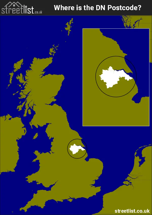
Where is the DN Postcode Area?
The DN Doncaster postcode has it's North is in the Yorkshire and the Humber region and it's South is in the East Midlands of England. The postal area borders the following neighbouring postal areas: LN - Lincoln, WF - Wakefield, NG - Nottingham, YO - York, S - Sheffield and HU - Hull, It also borders The North Sea and The Humber.
Map of the DN Doncaster Postcode Area
Explore the DN Doncaster postcode area by using our interactive map.
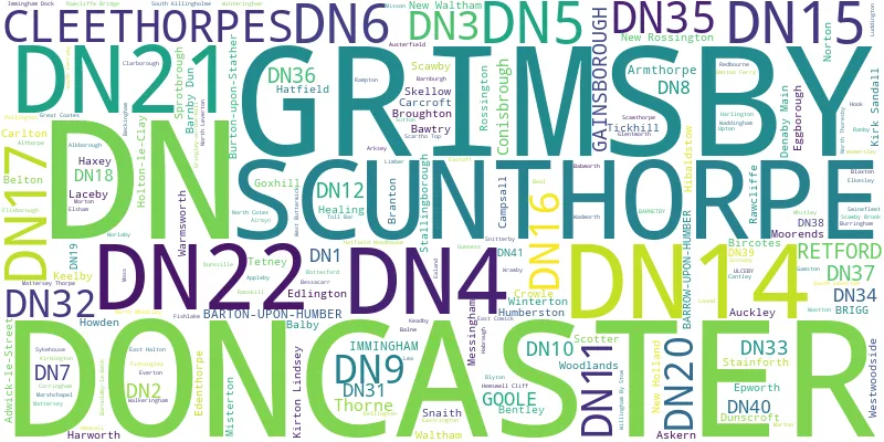
Postcode Districts within the DN Doncaster Postcode Area
There are 32 postcode districts within the Doncaster postcode area

A map showing the boundary of in relation to other areas
There are 21 towns within the Doncaster postcode area.

| Unit | Area² |
|---|---|
| Hectares | 2,812,196² |
| Miles | 10,858² |
| Feet | 302,701,965,244² |
| Kilometres | 28,122² |
Postal Delivery Offices serving the DN Doncaster Postcode Area
- Armthorpe Scale Payment Delivery Office
- Askern Scale Payment Delivery Office
- Barnby Dun Scale Payment Delivery Office
- Barton-upon-humber Delivery Office
- Bawtry Scale Payment Delivery Office
- Belton Scale Payment Delivery Office (dn)
- Bircotes Scale Payment Delivery Office
- Brigg Delivery Office
- Carcroft Scale Payment Delivery Office
- Conisbrough Scale Payment Delivery Office
- Crowle Scale Payment Delivery Office
- Denaby Main Scale Payment Delivery Office
- Doncaster Delivery Office
- Epworth Scale Payment Delivery Office
- Finningley Scale Payment Delivery Office
- Gainsborough Delivery Office
- Goole Delivery Office
- Grimsby Delivery Office
- Gringley-on-the-hill Scale Payment Delivery Office
- Hatfield (dn) Scale Payment Delivery Office
- Haxey Scale Payment Delivery Office
- Immingham Delivery Office
- Misterton Scale Payment Delivery Office
- New Rossington Scale Payment Delivery Office
- Owston Ferry Scale Payment Delivery Office
- Retford Delivery Office
- Scunthorpe Delivery Office
- Stainforth Scale Payment Delivery Office
- Thorne Scale Payment Delivery Office
- Tickhill Scale Payment Delivery Office
- Walkeringham Scale Payment Delivery Office
- Westwoodside Scale Payment Delivery Office
- Woodlands Scale Payment Delivery Office
Councils with Postcodes in DN
Towns and Villages within the DN Doncaster Postcode Area
- Adlingfleet - village
- Adwick le Street - town
- Airmyn - village
- Alkborough - village
- Althorpe - village
- Amcotts - village
- Appleby - village
- Arksey - village
- Armthorpe - village
- Ashby cum Fenby - village
- Askern - village
- Asselby - village
- Auckley - village
- Austerfield - village
- Aylesby - village
- Babworth - otherSettlement
- Balkholme - otherSettlement
- Barmby on the Marsh - village
- Barnburgh - village
- Barnby Dun - village
- Barnby Moor - village
- Barnetby le Wold - village
- Barnoldby le Beck - village
- Barrow upon Humber - village
- Barton-upon-Humber - town
- Bawtry - town
- Beal - village
- Beckingham - village
- Beelsby - village
- Beltoft - village
- Belton - village
- Bentley - town
- Bigby - village
- Bircotes - village
- Blacktoft - village
- Blaxton - village
- Blyton - village
- Bole - village
- Booth - otherSettlement
- Bothamsall - village
- Bradley - village
- Braithwaite - village
- Branton - village
- Brigg - town
- Brigsley - village
- Brocklesby - village
- Brodsworth - village
- Broughton - village
- Burghwallis - village
- Burringham - village
- Burton upon Stather - village
- Cadeby - village
- Campsall - village
- Carlton - village
- Clarborough - village
- Clayton - village
- Clayworth - village
- Cleethorpes - town
- Conisbrough - town
- Corringham - village
- Cottam - village
- Crowle - town
- Cusworth - village
- Denaby Main - village
- Doncaster - town
- Dunscroft - village
- Dunsville - village
- Ealand - village
- East Butterwick - village
- East Cowick - village
- East Drayton - village
- East Halton - village
- East Lound - village
- East Stockwith - village
- Eastoft - village
- Eastrington - village
- Eaton - village
- Edenthorpe - village
- Eggborough - village
- Elkesley - village
- Elsham - village
- Epworth - town
- Everton - village
- Far Bank - village
- Faxfleet - otherSettlement
- Fenwick - village
- Ferriby Sluice - village
- Fillingham - village
- Finningley - village
- Fishlake - village
- Flixborough - village
- Flixborough Stather - otherSettlement
- Fockerby - village
- Gainsborough - town
- Gamston - village
- Garthorpe - village
- Glentworth - village
- Goole - town
- Gowdall - village
- Goxhill - village
- Graizelound - village
- Grasby - village
- Grayingham - village
- Great Heck - village
- Great Limber - village
- Greetwell - village
- Grimsby - town
- Gringley on the Hill - village
- Grove - village
- Gunness - village
- Habrough - village
- Harlington - village
- Harworth - village
- Hatfield - village
- Hatfield Woodhouse - village
- Haxey - village
- Hayfield Green - village
- Hayton - village
- Healing - village
- Hemswell - village
- Hemswell Cliff - village
- Hensall - village
- Hibaldstow - village
- Hickleton - village
- High Melton - village
- Holton le Clay - village
- Hook - village
- Hooton Pagnell - village
- Horkstow - village
- Howden - town
- Humberston - village
- Immingham - town
- Irby upon Humber - village
- Keadby - village
- Keelby - village
- Kellingley - village
- Kellington - village
- Kexby - village
- Kilpin Pike - village
- Kirk Sandall - village
- Kirkhouse Green - village
- Kirmington - village
- Kirton in Lindsey - town
- Knaith Park - village
- Laceby - village
- Laneham - village
- Laughton - village
- Laxton - village
- Lea - village
- Lound - village
- Loversall - village
- Ludborough - village
- Luddington - village
- Markham Moor - village
- Marr - village
- Marshchapel - village
- Marton - village
- Mattersey - village
- Mattersey Thorpe - village
- Melton Ross - village
- Messingham - village
- Misson - village
- Misterton - village
- Moorends - village
- Moss - village
- New Edlington - village
- New Holland - village
- New Rossington - village
- New Waltham - village
- Normanby - village
- North Cotes - village
- North Killingholme - village
- North Leverton with Habblesthorpe - village
- North Thoresby - village
- North Wheatley - village
- Northorpe - village
- Norton - village
- Old Cantley - village
- Old Denaby - village
- Old Edlington - village
- Owston Ferry - village
- Pickburn - village
- Pincheon Green - otherSettlement
- Pollington - village
- Rampton - village
- Ranby - village
- Ranskill - village
- Rawcliffe - village
- Rawcliffe Bridge - village
- Redbourne - village
- Reedness - village
- Retford - town
- Riby - village
- Rockley - village
- Rossington - village
- Roxby - village
- Sandtoft - village
- Saundby - village
- Saxby All Saints - village
- Scawby - village
- Scawby Brook - village
- Scawsby - village
- Scawthorpe - village
- Scotter - village
- Scotton - village
- Scrooby - village
- Scunthorpe - town
- Searby - village
- Skelbrooke - village
- Skelton - village
- Snaith - village
- Snitterby - village
- South End - otherSettlement
- South Ferriby - village
- South Killingholme - village
- South Leverton - village
- South Wheatley - village
- Spaldington - village
- Springthorpe - village
- Sprotbrough - village
- Stainforth - village
- Stallingborough - village
- Sturton le Steeple - village
- Styrrup - village
- Sutton - village
- Sutton cum Lound - village
- Swinefleet - village
- Sykehouse - village
- Tetney - village
- Thealby - village
- Thorne - town
- Thornton Curtis - village
- Thorpe in Balne - village
- Tickhill - town
- Toll Bar - village
- Torworth - village
- Treswell - village
- Ulceby - village
- Ulceby Skitter - village
- Upton - village
- Waddingham - village
- Wadworth - village
- Walkeringham - village
- Waltham - village
- Warmsworth - village
- Welham - village
- West Butterwick - village
- West Cowick - village
- West Drayton - village
- West End - village
- West Halton - village
- West Stockwith - village
- Westwoodside - village
- Whitgift - village
- Whitley - village
- Whitton - village
- Willingham by Stow - village
- Willoughton - village
- Winteringham - village
- Winterton - town
- Womersley - village
- Woodbeck - village
- Wootton - village
- Worlaby - village
- Wrawby - village
- Wressle - village
- Wroot - village