The DN20 postcode district is a postal district located in the DN Doncaster postcode area with a population of 19,197 residents according to the 2021 England and Wales Census.
The area of the DN20 postcode district is 52.48 square miles which is 135.91 square kilometres or 33,585.01 acres.
Currently, the DN20 district has about 665 postcode units spread across 3 geographic postcode sectors.
Given that each sector allows for 400 unique postcode combinations, the district has a capacity of 1,200 postcodes. With 665 postcodes already in use, this leaves 535 units available.
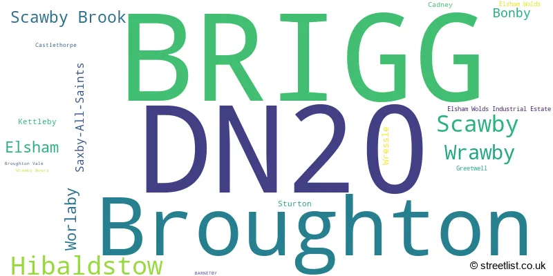
The largest settlement in the DN20 postal code is BRIGG followed by Broughton, and Hibaldstow.
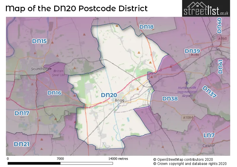
The DN20 Postcode shares a border with DN21 (GAINSBOROUGH, Kirton Lindsey, Scotter), DN15 (SCUNTHORPE, Winterton, Burton-upon-Stather), DN16 (SCUNTHORPE, Bottesford), DN38 (BARNETBY, Grasby, Melton Ross), LN7 (Caistor, North Kelsey, Nettleton) and DN18 (BARTON-UPON-HUMBER, South Ferriby, Horkstow).
In the DN20 postcode district, the primary settlement is Brigg, which is located in the county of Lincolnshire in England. Other significant settlements in the district include Broughton, Elsham, Saxby-All-Saints, Worlaby, Wrawby, and Scawby. The most significant post town in this district is Brigg.
For the district DN20, we have data on 4 postcode sectors. Here's a breakdown: The sector DN20 0, covers Broughton and Elsham and Worlaby in Lincolnshire. The sector DN20 2 is non-geographic. It's often designated for PO Boxes, large organisations, or special services. The sector DN20 8, covers Brigg and Wrawby in Lincolnshire. The sector DN20 9, covers Hibaldstow and Scawby and Scawby Brook in Lincolnshire.

Map of the DN20 Postcode District
Explore the DN20 postcode district by using our free interactive map.
When it comes to local government, postal geography often disregards political borders. However, for a breakdown in the DN20 District: the district mostly encompasses the North Lincolnshire (B) (659 postcodes), and finally, the West Lindsey District area (11 postcodes).
Weather Forecast for DN20
Press Button to Show Forecast for Brigg
| Time Period | Icon | Description | Temperature | Rain Probability | Wind |
|---|---|---|---|---|---|
| 12:00 to 15:00 | Cloudy | 10.0°C (feels like 7.0°C) | 15.00% | ENE 11 mph | |
| 15:00 to 18:00 | Overcast | 9.0°C (feels like 6.0°C) | 51.00% | ENE 11 mph | |
| 18:00 to 21:00 | Overcast | 8.0°C (feels like 5.0°C) | 11.00% | NE 9 mph | |
| 21:00 to 00:00 | Cloudy | 7.0°C (feels like 4.0°C) | 9.00% | NE 9 mph |
Press Button to Show Forecast for Brigg
| Time Period | Icon | Description | Temperature | Rain Probability | Wind |
|---|---|---|---|---|---|
| 00:00 to 03:00 | Cloudy | 6.0°C (feels like 4.0°C) | 14.00% | NNE 9 mph | |
| 03:00 to 06:00 | Cloudy | 6.0°C (feels like 3.0°C) | 53.00% | NNE 11 mph | |
| 06:00 to 09:00 | Heavy rain | 7.0°C (feels like 3.0°C) | 79.00% | N 13 mph | |
| 09:00 to 12:00 | Heavy rain | 7.0°C (feels like 4.0°C) | 82.00% | N 13 mph | |
| 12:00 to 15:00 | Heavy rain | 8.0°C (feels like 5.0°C) | 76.00% | NW 11 mph | |
| 15:00 to 18:00 | Light rain | 9.0°C (feels like 7.0°C) | 51.00% | WNW 11 mph | |
| 18:00 to 21:00 | Overcast | 10.0°C (feels like 8.0°C) | 14.00% | WSW 7 mph | |
| 21:00 to 00:00 | Clear night | 7.0°C (feels like 5.0°C) | 3.00% | SW 7 mph |
Press Button to Show Forecast for Brigg
| Time Period | Icon | Description | Temperature | Rain Probability | Wind |
|---|---|---|---|---|---|
| 00:00 to 03:00 | Clear night | 5.0°C (feels like 3.0°C) | 3.00% | SSW 7 mph | |
| 03:00 to 06:00 | Clear night | 4.0°C (feels like 1.0°C) | 1.00% | SSW 7 mph | |
| 06:00 to 09:00 | Sunny day | 5.0°C (feels like 2.0°C) | 1.00% | S 9 mph | |
| 09:00 to 12:00 | Partly cloudy (day) | 11.0°C (feels like 9.0°C) | 1.00% | S 11 mph | |
| 12:00 to 15:00 | Cloudy | 14.0°C (feels like 11.0°C) | 6.00% | S 13 mph | |
| 15:00 to 18:00 | Cloudy | 14.0°C (feels like 11.0°C) | 6.00% | S 13 mph | |
| 18:00 to 21:00 | Partly cloudy (day) | 13.0°C (feels like 11.0°C) | 1.00% | SSE 9 mph | |
| 21:00 to 00:00 | Partly cloudy (night) | 10.0°C (feels like 8.0°C) | 2.00% | SSE 11 mph |
Press Button to Show Forecast for Brigg
| Time Period | Icon | Description | Temperature | Rain Probability | Wind |
|---|---|---|---|---|---|
| 00:00 to 03:00 | Clear night | 8.0°C (feels like 6.0°C) | 2.00% | SE 9 mph | |
| 03:00 to 06:00 | Clear night | 7.0°C (feels like 5.0°C) | 2.00% | SE 9 mph | |
| 06:00 to 09:00 | Sunny day | 8.0°C (feels like 6.0°C) | 5.00% | ESE 9 mph | |
| 09:00 to 12:00 | Cloudy | 13.0°C (feels like 11.0°C) | 7.00% | ESE 9 mph | |
| 12:00 to 15:00 | Cloudy | 15.0°C (feels like 13.0°C) | 11.00% | ESE 11 mph | |
| 15:00 to 18:00 | Cloudy | 15.0°C (feels like 13.0°C) | 11.00% | ESE 11 mph | |
| 18:00 to 21:00 | Cloudy | 13.0°C (feels like 12.0°C) | 8.00% | E 9 mph | |
| 21:00 to 00:00 | Cloudy | 11.0°C (feels like 9.0°C) | 9.00% | E 7 mph |
Where is the DN20 Postcode District?
The DN20 postcode district is located in the town of Brigg. It is situated in close proximity to several nearby towns. To the east is Barnetby, which is approximately 4.49 miles away. To the west is Scunthorpe, which is about 6.74 miles away. To the north is Barton-Upon-Humber, which is approximately 7.4 miles away. Additionally, to the northeast is Ulceby, which is approximately 8.58 miles away. Furthermore, the DN20 postcode district is situated at a distance of 143.30 miles from the center of London.
The district is within the post town of BRIGG.
The sector has postcodes within the nation of England.
The DN20 Postcode District is covers the following regions.
- North and North East Lincolnshire - East Yorkshire and Northern Lincolnshire - Yorkshire and The Humber
- Lincolnshire - Lincolnshire - East Midlands (England)
| Postcode Sector | Delivery Office |
|---|---|
| DN20 0 | Brigg Delivery Office |
| DN20 8 | Brigg Delivery Office |
| DN20 9 | Brigg Delivery Office |
| D | N | 2 | 0 | - | X | X | X |
| D | N | 2 | 0 | Space | Numeric | Letter | Letter |
Current Monthly Rental Prices
| # Bedrooms | Min Price | Max Price | Avg Price |
|---|---|---|---|
| 1 | £350 | £675 | £528 |
| 2 | £635 | £995 | £780 |
| 3 | £550 | £725 | £638 |
| 4 | £1,250 | £1,600 | £1,425 |
Current House Prices
| # Bedrooms | Min Price | Max Price | Avg Price |
|---|---|---|---|
| £30,000 | £450,000 | £175,000 | |
| 1 | £25,000 | £85,000 | £64,983 |
| 2 | £75,000 | £380,000 | £196,634 |
| 3 | £115,000 | £525,000 | £230,795 |
| 4 | £202,500 | £595,000 | £321,451 |
| 5 | £216,000 | £995,000 | £495,323 |
| 6 | £850,000 | £850,000 | £850,000 |
Estate Agents who Operate in the DN20 District
| Logo | Name | Brand Name | Address | Contact Number | Total Properties |
|---|---|---|---|---|---|
 | Brigg | Paul Fox | 10 Market Place, Brigg, DN20 8ES | 01652 248427 | 54 |
 | Brigg | Newton Fallowell | Unit 1, 2 Wrawby Street, Brigg, DN20 8JH | 01652 783030 | 23 |
 | Brigg | DDM Residential | 72 Wrawby Street, Brigg, DN20 8JE | 01652 248429 | 22 |
 | Brigg | Bell Watson & Co | 66 Wrawby Street, Brigg, DN20 8JE | 01652 248430 | 17 |
 | Brigg | Lovelle Estate Agency | The Old Chapel Wrawby Street, Brigg, DN20 8JJ | 01652 248422 | 16 |
| Type of Property | 2018 Average | 2018 Sales | 2017 Average | 2017 Sales | 2016 Average | 2016 Sales | 2015 Average | 2015 Sales |
|---|---|---|---|---|---|---|---|---|
| Detached | £228,945 | 170 | £215,266 | 217 | £211,910 | 191 | £203,008 | 167 |
| Semi-Detached | £138,712 | 107 | £135,315 | 119 | £123,450 | 117 | £124,328 | 108 |
| Terraced | £117,601 | 59 | £115,774 | 54 | £111,731 | 55 | £108,742 | 54 |
| Flats | £106,000 | 5 | £98,441 | 11 | £93,455 | 11 | £107,830 | 10 |