The DN17 postcode district is a postal district located in the DN Doncaster postcode area with a population of 36,776 residents according to the 2021 England and Wales Census.
The area of the DN17 postcode district is 62.76 square miles which is 162.55 square kilometres or 40,166.55 acres.
Currently, the DN17 district has about 952 postcode units spread across 4 geographic postcode sectors.
Given that each sector allows for 400 unique postcode combinations, the district has a capacity of 1,600 postcodes. With 952 postcodes already in use, this leaves 648 units available.
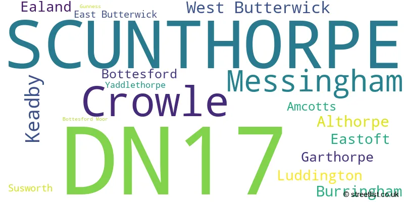
The largest settlement in the DN17 postal code is SCUNTHORPE followed by Crowle, and Messingham.
The postcode area has a boundary with The Humber.
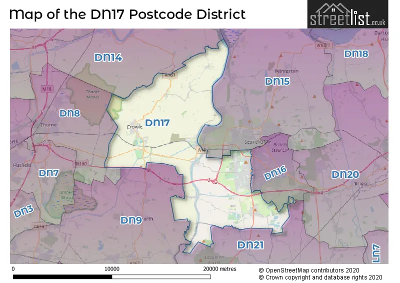
The DN17 Postcode shares a border with DN14 (GOOLE, Howden, Eggborough), DN21 (GAINSBOROUGH, Kirton Lindsey, Scotter), DN9 (Epworth, Auckley, Belton), DN15 (SCUNTHORPE, Winterton, Burton-upon-Stather) and DN16 (SCUNTHORPE, Bottesford).
The primary settlement in the DN17 postcode district is Scunthorpe in the county of Lincolnshire, England. Other significant settlements in this district include Bottesford, Bottesford Moor, Yaddlethorpe, Althorpe, Burringham, East Butterwick, Gunness, Keadby, Messingham, Susworth, West Butterwick, Amcotts, Crowle, Ealand, Eastoft, Garthorpe, and Luddington.
For the district DN17, we have data on 4 postcode sectors. Here's a breakdown: The sector DN17 1, covers Scunthorpe in Lincolnshire. The sector DN17 2, covers Scunthorpe in Lincolnshire. The sector DN17 3, covers Messingham and Keadby and West Butterwick in Lincolnshire. The sector DN17 4, covers Crowle in Lincolnshire.

Map of the DN17 Postcode District
Explore the DN17 postcode district by using our free interactive map.
When it comes to local government, postal geography often disregards political borders. However, for a breakdown in the DN17 District: the district mostly encompasses the North Lincolnshire (B) (954 postcodes), and finally, the West Lindsey District area (5 postcodes).
Weather Forecast for DN17
Press Button to Show Forecast for Crowle
| Time Period | Icon | Description | Temperature | Rain Probability | Wind |
|---|---|---|---|---|---|
| 06:00 to 09:00 | Cloudy | 5.0°C (feels like 2.0°C) | 5.00% | NNE 7 mph | |
| 09:00 to 12:00 | Cloudy | 9.0°C (feels like 6.0°C) | 8.00% | ENE 9 mph | |
| 12:00 to 15:00 | Cloudy | 10.0°C (feels like 7.0°C) | 16.00% | ENE 11 mph | |
| 15:00 to 18:00 | Overcast | 9.0°C (feels like 6.0°C) | 51.00% | ENE 11 mph | |
| 18:00 to 21:00 | Overcast | 8.0°C (feels like 6.0°C) | 11.00% | ENE 9 mph | |
| 21:00 to 00:00 | Cloudy | 6.0°C (feels like 4.0°C) | 7.00% | NNE 7 mph |
Press Button to Show Forecast for Crowle
| Time Period | Icon | Description | Temperature | Rain Probability | Wind |
|---|---|---|---|---|---|
| 00:00 to 03:00 | Cloudy | 6.0°C (feels like 3.0°C) | 7.00% | NNE 9 mph | |
| 03:00 to 06:00 | Cloudy | 6.0°C (feels like 3.0°C) | 19.00% | N 11 mph | |
| 06:00 to 09:00 | Light rain | 6.0°C (feels like 3.0°C) | 55.00% | N 11 mph | |
| 09:00 to 12:00 | Heavy rain | 7.0°C (feels like 4.0°C) | 80.00% | NNW 13 mph | |
| 12:00 to 15:00 | Heavy rain | 8.0°C (feels like 5.0°C) | 77.00% | NW 11 mph | |
| 15:00 to 18:00 | Light rain | 10.0°C (feels like 7.0°C) | 48.00% | WNW 11 mph | |
| 18:00 to 21:00 | Cloudy | 10.0°C (feels like 8.0°C) | 11.00% | WSW 7 mph | |
| 21:00 to 00:00 | Clear night | 7.0°C (feels like 5.0°C) | 3.00% | SW 7 mph |
Press Button to Show Forecast for Crowle
| Time Period | Icon | Description | Temperature | Rain Probability | Wind |
|---|---|---|---|---|---|
| 00:00 to 03:00 | Clear night | 5.0°C (feels like 3.0°C) | 1.00% | SSW 7 mph | |
| 03:00 to 06:00 | Clear night | 4.0°C (feels like 2.0°C) | 1.00% | SSW 7 mph | |
| 06:00 to 09:00 | Sunny day | 5.0°C (feels like 2.0°C) | 1.00% | S 9 mph | |
| 09:00 to 12:00 | Sunny day | 11.0°C (feels like 8.0°C) | 1.00% | S 11 mph | |
| 12:00 to 15:00 | Cloudy | 14.0°C (feels like 11.0°C) | 5.00% | S 13 mph | |
| 15:00 to 18:00 | Cloudy | 14.0°C (feels like 11.0°C) | 6.00% | S 13 mph | |
| 18:00 to 21:00 | Sunny day | 13.0°C (feels like 11.0°C) | 2.00% | SSE 9 mph | |
| 21:00 to 00:00 | Clear night | 10.0°C (feels like 8.0°C) | 2.00% | SSE 9 mph |
Press Button to Show Forecast for Crowle
| Time Period | Icon | Description | Temperature | Rain Probability | Wind |
|---|---|---|---|---|---|
| 00:00 to 03:00 | Clear night | 8.0°C (feels like 6.0°C) | 2.00% | SSE 9 mph | |
| 03:00 to 06:00 | Clear night | 7.0°C (feels like 5.0°C) | 3.00% | SE 7 mph | |
| 06:00 to 09:00 | Sunny day | 8.0°C (feels like 6.0°C) | 4.00% | ESE 7 mph | |
| 09:00 to 12:00 | Partly cloudy (day) | 13.0°C (feels like 11.0°C) | 4.00% | ESE 9 mph | |
| 12:00 to 15:00 | Cloudy | 15.0°C (feels like 13.0°C) | 11.00% | ESE 11 mph | |
| 15:00 to 18:00 | Cloudy | 15.0°C (feels like 13.0°C) | 11.00% | ESE 11 mph | |
| 18:00 to 21:00 | Cloudy | 14.0°C (feels like 12.0°C) | 9.00% | E 9 mph | |
| 21:00 to 00:00 | Cloudy | 11.0°C (feels like 9.0°C) | 9.00% | E 7 mph |
Where is the DN17 Postcode District?
The data shows that the postcode district DN17 is located in the town of Scunthorpe. Scunthorpe is surrounded by several nearby towns, including Goole to the North West (10.16 miles away), Brigg to the East (11.04 miles away), Brough to the North East (12.45 miles away), Gainsborough to the South (12.62 miles away), and Doncaster to the West (16.21 miles away). Additionally, Scunthorpe is approximately 146.02 miles away from the center of London.
The district is within the post town of SCUNTHORPE.
The sector has postcodes within the nation of England.
The DN17 Postcode District is covers the following regions.
- North and North East Lincolnshire - East Yorkshire and Northern Lincolnshire - Yorkshire and The Humber
- Lincolnshire - Lincolnshire - East Midlands (England)
| Postcode Sector | Delivery Office |
|---|---|
| DN17 1 | Scunthorpe Delivery Office |
| DN17 2 | Scunthorpe Delivery Office |
| DN17 3 | Scunthorpe Delivery Office |
| DN17 4 | Scunthorpe Delivery Office |
| DN17 4 | Crowle Scale Payment Delivery Office |
| D | N | 1 | 7 | - | X | X | X |
| D | N | 1 | 7 | Space | Numeric | Letter | Letter |
Current Monthly Rental Prices
| # Bedrooms | Min Price | Max Price | Avg Price |
|---|---|---|---|
| £390 | £390 | £390 | |
| 1 | £390 | £667 | £598 |
| 2 | £443 | £525 | £484 |
| 3 | £650 | £850 | £783 |
Current House Prices
| # Bedrooms | Min Price | Max Price | Avg Price |
|---|---|---|---|
| £110,000 | £1,150,000 | £455,685 | |
| 1 | £69,950 | £145,000 | £107,475 |
| 2 | £60,000 | £460,000 | £150,370 |
| 3 | £75,000 | £650,000 | £204,027 |
| 4 | £115,000 | £850,000 | £348,452 |
| 5 | £250,000 | £725,000 | £471,000 |
| 6 | £280,000 | £950,000 | £585,000 |
| 7 | £800,000 | £800,000 | £800,000 |
Estate Agents who Operate in the DN17 District
| Logo | Name | Brand Name | Address | Contact Number | Total Properties |
|---|---|---|---|---|---|
 | Scunthorpe | Walshe's Property | 12 Oswald Road, Scunthorpe, DN15 7PT | 01724 304604 | 37 |
 | Scunthorpe | Paul Fox | 29-31 Oswald Road, Scunthorpe, North Lincolnshire, DN15 7PN | 01724 514331 | 22 |
 | Scunthorpe | EA Ben Cade | 2-4 Oswald Road, Scunthorpe, DN15 7PT | 01724 706881 | 21 |
 | Epworth | Grice and Hunter | 23 High Street, Epworth, DN9 1EP | 01427 800760 | 16 |
 | Scunthorpe | Bella Properties | 21 Dunstall Street, Scunthorpe, DN15 6LD | 01724 706790 | 16 |
| Type of Property | 2018 Average | 2018 Sales | 2017 Average | 2017 Sales | 2016 Average | 2016 Sales | 2015 Average | 2015 Sales |
|---|---|---|---|---|---|---|---|---|
| Detached | £208,897 | 199 | £197,601 | 213 | £196,018 | 199 | £179,919 | 171 |
| Semi-Detached | £121,383 | 271 | £114,328 | 300 | £109,985 | 248 | £103,765 | 240 |
| Terraced | £98,902 | 82 | £91,266 | 93 | £87,505 | 78 | £84,162 | 82 |
| Flats | £64,243 | 7 | £57,619 | 21 | £58,247 | 10 | £53,350 | 10 |