The DN36 postcode district is a postal district located in the DN Doncaster postcode area with a population of 20,537 residents according to the 2021 England and Wales Census.
The area of the DN36 postcode district is 41.66 square miles which is 107.90 square kilometres or 26,662.79 acres.
Currently, the DN36 district has about 626 postcode units spread across 2 geographic postcode sectors.
Given that each sector allows for 400 unique postcode combinations, the district has a capacity of 800 postcodes. With 626 postcodes already in use, this leaves 174 units available.
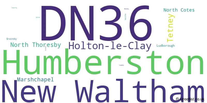
The largest settlement in the DN36 postal code is Humberston followed by New Waltham, and Holton-le-Clay.
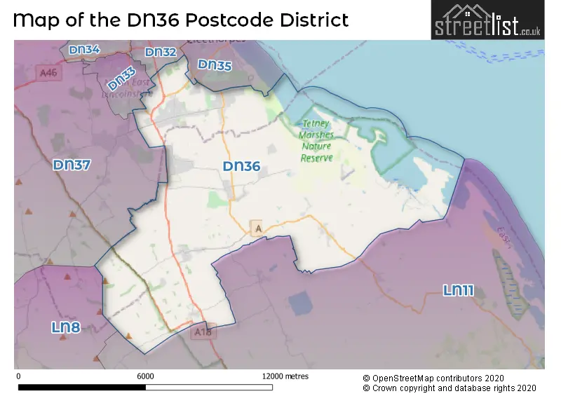
The postcode area has a boundary with The North Sea and The Humber.
The DN36 Postcode shares a border with LN11 (LOUTH, North Somercotes, Saltfleet), DN32 (GRIMSBY), DN33 (GRIMSBY, Scartho Top), DN35 (CLEETHORPES) and DN37 (GRIMSBY, Waltham, Laceby).
The primary settlement in the DN36 postcode district is Humberston, located in the county of Lincolnshire in England. Other significant settlements include New Waltham, Holton-le-Clay, Ludborough, Marshchapel, North Cotes, North Thoresby, and Tetney. The post town for this district is Grimsby.
For the district DN36, we have data on 2 postcode sectors. Here's a breakdown: The sector DN36 4, covers Humberston and New Waltham in Lincolnshire. The sector DN36 5, covers Holton-Le-Clay and Tetney and North Thoresby in Lincolnshire.

Map of the DN36 Postcode District
Explore the DN36 postcode district by using our free interactive map.
When it comes to local government, postal geography often disregards political borders. However, for a breakdown in the DN36 District: the district mostly encompasses the North East Lincolnshire (B) (358 postcodes), and finally, the East Lindsey District area (286 postcodes).
Weather Forecast for DN36
Press Button to Show Forecast for Donna Nook
| Time Period | Icon | Description | Temperature | Rain Probability | Wind |
|---|---|---|---|---|---|
| 09:00 to 12:00 | Cloudy | 7.0°C (feels like 5.0°C) | 37.00% | NE 9 mph | |
| 12:00 to 15:00 | Cloudy | 9.0°C (feels like 6.0°C) | 27.00% | ENE 11 mph | |
| 15:00 to 18:00 | Partly cloudy (day) | 9.0°C (feels like 6.0°C) | 5.00% | ENE 13 mph | |
| 18:00 to 21:00 | Partly cloudy (day) | 8.0°C (feels like 5.0°C) | 4.00% | E 11 mph | |
| 21:00 to 00:00 | Partly cloudy (night) | 6.0°C (feels like 4.0°C) | 3.00% | E 9 mph |
Press Button to Show Forecast for Donna Nook
| Time Period | Icon | Description | Temperature | Rain Probability | Wind |
|---|---|---|---|---|---|
| 00:00 to 03:00 | Cloudy | 6.0°C (feels like 3.0°C) | 7.00% | E 9 mph | |
| 03:00 to 06:00 | Partly cloudy (night) | 5.0°C (feels like 3.0°C) | 6.00% | ENE 9 mph | |
| 06:00 to 09:00 | Cloudy | 7.0°C (feels like 4.0°C) | 8.00% | ENE 9 mph | |
| 09:00 to 12:00 | Cloudy | 8.0°C (feels like 6.0°C) | 11.00% | E 13 mph | |
| 12:00 to 15:00 | Cloudy | 10.0°C (feels like 7.0°C) | 14.00% | E 16 mph | |
| 15:00 to 18:00 | Cloudy | 10.0°C (feels like 7.0°C) | 13.00% | ENE 16 mph | |
| 18:00 to 21:00 | Cloudy | 9.0°C (feels like 6.0°C) | 8.00% | ENE 16 mph | |
| 21:00 to 00:00 | Cloudy | 9.0°C (feels like 5.0°C) | 14.00% | ENE 16 mph |
Press Button to Show Forecast for Donna Nook
| Time Period | Icon | Description | Temperature | Rain Probability | Wind |
|---|---|---|---|---|---|
| 00:00 to 03:00 | Cloudy | 8.0°C (feels like 5.0°C) | 20.00% | NE 16 mph | |
| 03:00 to 06:00 | Light rain | 8.0°C (feels like 5.0°C) | 51.00% | NE 18 mph | |
| 06:00 to 09:00 | Heavy rain | 8.0°C (feels like 5.0°C) | 73.00% | NE 16 mph | |
| 09:00 to 12:00 | Heavy rain | 10.0°C (feels like 7.0°C) | 75.00% | E 16 mph | |
| 12:00 to 15:00 | Light rain shower (day) | 11.0°C (feels like 8.0°C) | 41.00% | ENE 18 mph | |
| 15:00 to 18:00 | Heavy rain shower (day) | 11.0°C (feels like 7.0°C) | 59.00% | NE 18 mph | |
| 18:00 to 21:00 | Light rain | 10.0°C (feels like 7.0°C) | 47.00% | NE 16 mph | |
| 21:00 to 00:00 | Cloudy | 9.0°C (feels like 6.0°C) | 9.00% | SSW 11 mph |
Where is the DN36 Postcode District?
The DN36 postcode district, located in Grimsby, is associated with nearby towns. To the north is Cleethorpes, which is approximately 4.47 miles away. Louth is situated to the south, approximately 8.26 miles away. Immingham is found to the northwest at a distance of approximately 11.73 miles. Mablethorpe is to the southeast, about 14.74 miles away. Barnetby lies to the west, approximately 16.60 miles away. Lastly, Market Rasen is located to the southwest at a distance of around 16.92 miles. In terms of the centre of London, the DN36 postcode district is approximately 136.95 miles away.
The district is within the post town of GRIMSBY.
The sector has postcodes within the nation of England.
The DN36 Postcode District is covers the following regions.
- North and North East Lincolnshire - East Yorkshire and Northern Lincolnshire - Yorkshire and The Humber
- Lincolnshire - Lincolnshire - East Midlands (England)
| Postcode Sector | Delivery Office |
|---|---|
| DN36 4 | Grimsby Delivery Office |
| DN36 5 | Grimsby Delivery Office |
| D | N | 3 | 6 | - | X | X | X |
| D | N | 3 | 6 | Space | Numeric | Letter | Letter |
Tourist Attractions within the Postcode Area
We found 1 visitor attractions within the DN36 postcode area
| Lincolnshire Wolds Railway |
|---|
| Railways |
| Steam / Heritage Railway |
| View Lincolnshire Wolds Railway on Google Maps |
Current Monthly Rental Prices
| # Bedrooms | Min Price | Max Price | Avg Price |
|---|---|---|---|
| 1 | £1,500 | £1,500 | £1,500 |
| 2 | £550 | £750 | £667 |
| 3 | £750 | £1,145 | £939 |
| 4 | £1,200 | £2,200 | £1,700 |
Current House Prices
| # Bedrooms | Min Price | Max Price | Avg Price |
|---|---|---|---|
| £50,000 | £850,000 | £252,188 | |
| 1 | £57,000 | £84,995 | £70,486 |
| 2 | £41,875 | £340,000 | £154,055 |
| 3 | £34,995 | £525,000 | £226,847 |
| 4 | £174,950 | £850,000 | £377,139 |
| 5 | £289,995 | £995,000 | £532,660 |
| 6 | £399,950 | £1,250,000 | £586,632 |
| 7 | £725,000 | £725,000 | £725,000 |
| 8 | £1,600,000 | £1,600,000 | £1,600,000 |
Estate Agents who Operate in the DN36 District
| Logo | Name | Brand Name | Address | Contact Number | Total Properties |
|---|---|---|---|---|---|
 | Cleethorpes | Crofts Estate Agents | 62 St. Peters Avenue, Cleethorpes, DN35 8HP | 01472 404562 | 56 |
 | Humberston | Lovelle | 346 Grimsby Road Humberston DN36 4AA | 01472 404552 | 48 |
 | Cleethorpes | Joy Walker Estate Agents | 58 St. Peters Avenue, Cleethorpes, DN35 8HP | 01472 200818 | 41 |
 | Cleethorpes | Roost Estate Agents | 15 Highgate Cleethorpes DN35 8NR | 01472 404606 | 40 |
 | Grimsby | Jackson Green & Preston | 19 West St. Marys Gate, Grimsby, DN31 1LE | 01472 404357 | 35 |
| Type of Property | 2018 Average | 2018 Sales | 2017 Average | 2017 Sales | 2016 Average | 2016 Sales | 2015 Average | 2015 Sales |
|---|---|---|---|---|---|---|---|---|
| Detached | £248,972 | 253 | £242,445 | 233 | £216,746 | 204 | £219,581 | 192 |
| Semi-Detached | £151,549 | 169 | £152,690 | 140 | £148,909 | 148 | £145,053 | 151 |
| Terraced | £142,814 | 37 | £127,362 | 34 | £125,082 | 33 | £110,831 | 24 |
| Flats | £106,112 | 13 | £103,564 | 7 | £113,150 | 10 | £84,988 | 4 |