
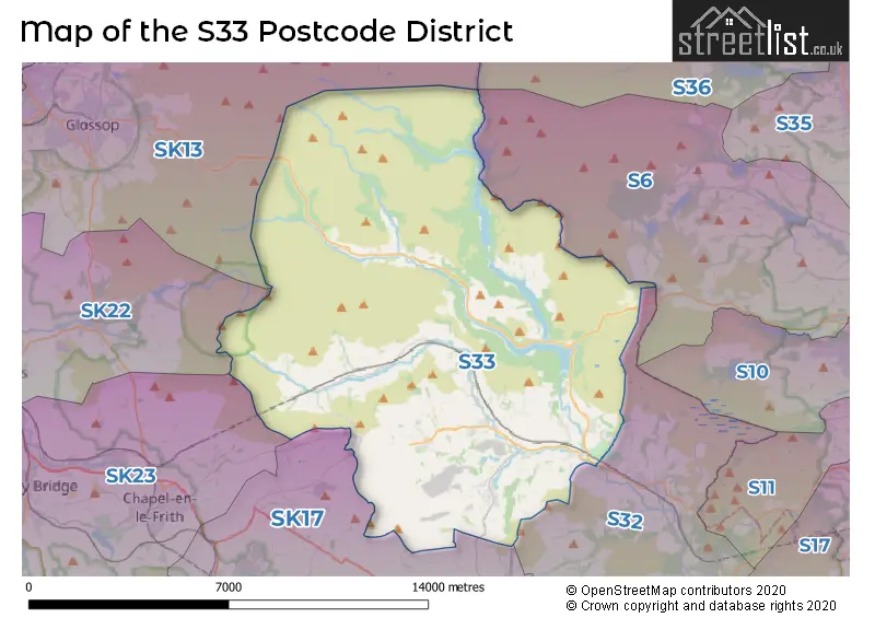
Map of the Postcode District
Explore the postcode district by using our interactive map.
Circles represent recorded crime; the larger the circle, the higher the crime rates.
Your support helps keep this site running!
If you enjoy using this website, consider buying me a coffee to help cover hosting costs.
The postcode district located in the S Sheffield postal area , S33 has a population of 4,608 residents according to the 2021 England and Wales Census.
The area of the district is 61.31 square miles (158.80 square kilometers or 39,239.16 acres).
Where is the S33 District?
To give you an idea where the district is located we have created the following table showing nearby towns.
Nearest Towns to S33
| Town | Distance (miles) | Direction |
|---|---|---|
| Chapel-en-le-Frith | 6.98 | SW |
| Glossop | 8.36 | WNW |
| Whaley Bridge | 9.41 | WSW |
| New Mills | 9.48 | W |
| Stocksbridge | 10.15 | NE |
| Buxton | 10.55 | SSW |
| Penistone | 11.54 | NNE |
| Marple | 12.00 | W |
| Bakewell | 12.40 | SSE |
| Sheffield | 12.64 | E |
| Holmfirth | 13.01 | N |
| Romiley | 13.28 | W |
| Dronfield | 13.49 | ESE |
| Hyde | 13.50 | WNW |
| Stalybridge | 13.61 | WNW |
| Dukinfield | 14.30 | WNW |
| Hazel Grove | 14.35 | W |
| Poynton | 14.58 | W |
| Bollington | 14.60 | WSW |
| Mossley | 14.64 | NW |
The post town for this district is HOPE VALLEY.
Postcode Information for District S33 (Total Geographical Postcodes: 170)
| Location | Post Town | Sector | Number of Postcodes |
|---|---|---|---|
| Bradwell | HOPE VALLEY | S33 9 | 59 |
| Bamford | HOPE VALLEY | S33 0 | 46 |
| Hope | HOPE VALLEY | S33 6 | 31 |
| Castleton | HOPE VALLEY | S33 8 | 20 |
| Edale | HOPE VALLEY | S33 7 | 13 |
| Hope | HOPE VALLEY | S33 8 | 1 |
Retail and Shopping in S33
Street
Town
Locality
Number of Shops
Central Postcode
View on Google Maps
CASTLETON ROAD
HOPE VALLEY
HOPE
12
S33 6RD
View on Google Maps
HOPE ROAD
HOPE VALLEY
BAMFORD
12
S33 0AL
View on Google Maps
CROSS STREET
HOPE VALLEY
CASTLETON
7
S33 8WH
View on Google Maps
NETHERSIDE
HOPE VALLEY
BRADWELL
6
S33 9JL
View on Google Maps
| Street | Town | Locality | Number of Shops | Central Postcode | View on Google Maps |
|---|---|---|---|---|---|
| CASTLETON ROAD | HOPE VALLEY | HOPE | 12 | S33 6RD | View on Google Maps |
| HOPE ROAD | HOPE VALLEY | BAMFORD | 12 | S33 0AL | View on Google Maps |
| CROSS STREET | HOPE VALLEY | CASTLETON | 7 | S33 8WH | View on Google Maps |
| NETHERSIDE | HOPE VALLEY | BRADWELL | 6 | S33 9JL | View on Google Maps |
The primary settlement in the S33 postcode district is Bamford in the county of Derbyshire, England. The other significant settlements in the district include Hope, Edale, Castleton, and Bradwell, also located in Derbyshire, England. The most significant post town in the district is Hope Valley.
When it comes to local government, postal geography often disregards political borders. However, this district intersects the following councils: the district mostly encompasses the High Peak District (B) (112 postal codes), and finally, the Derbyshire Dales District area (57 postal codes).
The largest settlement in the S33 postal code is Bamford followed by Bradwell, and Hope.
The S33 Postcode shares a border with S32 (Hathersage, Calver, Eyam), S6 (SHEFFIELD, Stannington, Loxley), SK13 (GLOSSOP, Hadfield, Tintwistle), SK17 (BUXTON, Tideswell, Dove Holes) and SK22 (New Mills, Hayfield, Birch Vale).


Schools in the Sector
Bamford Primary School
Phase: Primary
Address: Fidlers Well , Bamford , Hope Valley
Postcode: S33 0AR
Headteacher: Mrs Kate Gemmell (Headteacher)
Ofsted Rating: Good
Hope Valley College
Phase: Secondary
Address: Castleton Road , Hope , Hope Valley
Postcode: S33 6SD
Headteacher: Mr Paul Dearden (Principal)
Ofsted Rating: Serious Weaknesses
Hope Valley College
Phase: Secondary
Address: Castleton Road , Hope Valley
Postcode: S33 6SD
Headteacher: Mrs Gaynor Jones ()
Ofsted Rating: Good
Hope Primary School
Phase: Primary
Address: Edale Road , Hope , Hope Valley
Postcode: S33 6ZF
Headteacher: Mrs Sally Winfield (Headteacher)
Ofsted Rating: Good
Edale CofE Primary School
Phase: Primary
Address: Grindsbrook Booth , Edale , Hope Valley
Postcode: S33 7ZD
Headteacher: Mrs Sally Winfield (Executive Headteacher)
Ofsted Rating: Good
Castleton CofE Primary School
Phase: Primary
Address: Back Street , Castleton , Hope Valley
Postcode: S33 8WE
Headteacher: Mrs Jayne Jackson (Headteacher)
Ofsted Rating: Good
Bradwell CofE (Controlled) Infant School
Phase: Primary
Address: Church Street , Bradwell , Hope Valley
Postcode: S33 9HJ
Headteacher: Mrs Rebecca Gordine (Headteacher)
Ofsted Rating: Good
Bradwell Junior School
Phase: Primary
Address: Hugh Lane , Bradwell , Hope Valley
Postcode: S33 9JB
Headteacher: Mrs Kathryn McGuiness (Headteacher)
Ofsted Rating: Special Measures
Stations in the Sector
Hope (Derbyshire)
CRS Code: HOP
Operator: NT
Line: Hope Valley line
Company: Northern
Edale
CRS Code: EDL
Operator: NT
Line: Hope Valley line
Company: Northern
Accessable Motorway Junctions
M1 J35A
Average Driving Time from within the district: 28.25
Average Driving Distance: 21.19
Number of Postcodes that can access the Motorway Junction: 139
M1 J36
Average Driving Time from within the district: 28.44
Average Driving Distance: 20.79
Number of Postcodes that can access the Motorway Junction: 135
M1 J33
Average Driving Time from within the district: 29.10
Average Driving Distance: 18.84
Number of Postcodes that can access the Motorway Junction: 47
M1 J34
Average Driving Time from within the district: 30.26
Average Driving Distance: 18.65
Number of Postcodes that can access the Motorway Junction: 133
M1 J37
Average Driving Time from within the district: 30.50
Average Driving Distance: 23.14
Number of Postcodes that can access the Motorway Junction: 3
M67 J2
Average Driving Time from within the district: 32.53
Average Driving Distance: 21.75
Number of Postcodes that can access the Motorway Junction: 35
M1 J35
Average Driving Time from within the district: 33.17
Average Driving Distance: 21.40
Number of Postcodes that can access the Motorway Junction: 153
M67 J1
Average Driving Time from within the district: 33.91
Average Driving Distance: 22.35
Number of Postcodes that can access the Motorway Junction: 16
M60 J25
Average Driving Time from within the district: 33.91
Average Driving Distance: 20.96
Number of Postcodes that can access the Motorway Junction: 35
M60 J26
Average Driving Time from within the district: 33.96
Average Driving Distance: 21.00
Number of Postcodes that can access the Motorway Junction: 29
M67 J3
Average Driving Time from within the district: 34.66
Average Driving Distance: 22.47
Number of Postcodes that can access the Motorway Junction: 120
Weather Forecast for Edale Youth Hostel
| Time Period | Icon | Description | Temperature | Rain Probability | Wind |
|---|---|---|---|---|---|
| 12:00 to 15:00 | Partly cloudy (day) | 11.0°C (feels like 8.0°C) | 3.00% | W 13 mph | |
| 15:00 to 18:00 | Sunny day | 11.0°C (feels like 9.0°C) | 0.00% | W 7 mph | |
| 18:00 to 21:00 | Clear night | 7.0°C (feels like 5.0°C) | 0.00% | WSW 4 mph | |
| 21:00 to 00:00 | Clear night | 6.0°C (feels like 4.0°C) | 0.00% | SW 4 mph |
| Time Period | Icon | Description | Temperature | Rain Probability | Wind |
|---|---|---|---|---|---|
| 00:00 to 03:00 | Clear night | 6.0°C (feels like 5.0°C) | 0.00% | SW 7 mph | |
| 03:00 to 06:00 | Partly cloudy (night) | 7.0°C (feels like 5.0°C) | 1.00% | SW 7 mph | |
| 06:00 to 09:00 | Cloudy | 6.0°C (feels like 5.0°C) | 4.00% | SW 7 mph | |
| 09:00 to 12:00 | Cloudy | 9.0°C (feels like 7.0°C) | 4.00% | SSW 9 mph | |
| 12:00 to 15:00 | Cloudy | 11.0°C (feels like 9.0°C) | 4.00% | SSW 11 mph | |
| 15:00 to 18:00 | Cloudy | 11.0°C (feels like 9.0°C) | 4.00% | SSW 11 mph | |
| 18:00 to 21:00 | Partly cloudy (night) | 10.0°C (feels like 7.0°C) | 3.00% | S 9 mph | |
| 21:00 to 00:00 | Cloudy | 10.0°C (feels like 7.0°C) | 9.00% | S 11 mph |
| Time Period | Icon | Description | Temperature | Rain Probability | Wind |
|---|---|---|---|---|---|
| 00:00 to 03:00 | Overcast | 9.0°C (feels like 6.0°C) | 10.00% | S 13 mph | |
| 03:00 to 06:00 | Fog | 8.0°C (feels like 5.0°C) | 15.00% | S 13 mph | |
| 06:00 to 09:00 | Cloudy | 8.0°C (feels like 5.0°C) | 8.00% | S 16 mph | |
| 09:00 to 12:00 | Mist | 9.0°C (feels like 5.0°C) | 16.00% | SSE 16 mph | |
| 12:00 to 15:00 | Overcast | 11.0°C (feels like 8.0°C) | 10.00% | S 16 mph | |
| 15:00 to 18:00 | Cloudy | 12.0°C (feels like 9.0°C) | 9.00% | S 16 mph | |
| 18:00 to 21:00 | Overcast | 11.0°C (feels like 9.0°C) | 12.00% | SSE 13 mph | |
| 21:00 to 00:00 | Light rain | 11.0°C (feels like 8.0°C) | 47.00% | S 13 mph |
| Time Period | Icon | Description | Temperature | Rain Probability | Wind |
|---|---|---|---|---|---|
| 00:00 to 03:00 | Light rain | 11.0°C (feels like 8.0°C) | 57.00% | S 13 mph | |
| 03:00 to 06:00 | Light rain | 10.0°C (feels like 7.0°C) | 53.00% | SSW 13 mph | |
| 06:00 to 09:00 | Light rain shower (night) | 9.0°C (feels like 6.0°C) | 36.00% | SSW 11 mph | |
| 09:00 to 12:00 | Cloudy | 9.0°C (feels like 6.0°C) | 13.00% | SSW 11 mph | |
| 12:00 to 15:00 | Light rain shower (day) | 10.0°C (feels like 7.0°C) | 38.00% | SW 13 mph | |
| 15:00 to 18:00 | Light rain shower (day) | 9.0°C (feels like 6.0°C) | 39.00% | SW 13 mph | |
| 18:00 to 21:00 | Partly cloudy (night) | 7.0°C (feels like 4.0°C) | 14.00% | SSW 11 mph | |
| 21:00 to 00:00 | Overcast | 7.0°C (feels like 4.0°C) | 19.00% | SSW 11 mph |
| Time Period | Icon | Description | Temperature | Rain Probability | Wind |
|---|---|---|---|---|---|
| 00:00 to 03:00 | Partly cloudy (night) | 6.0°C (feels like 3.0°C) | 11.00% | SW 11 mph | |
| 03:00 to 06:00 | Cloudy | 6.0°C (feels like 2.0°C) | 19.00% | SW 13 mph | |
| 06:00 to 09:00 | Light rain | 6.0°C (feels like 3.0°C) | 51.00% | SW 13 mph | |
| 09:00 to 12:00 | Light rain | 8.0°C (feels like 4.0°C) | 53.00% | SW 16 mph | |
| 12:00 to 15:00 | Light rain | 9.0°C (feels like 6.0°C) | 55.00% | SW 16 mph | |
| 15:00 to 18:00 | Light rain | 9.0°C (feels like 6.0°C) | 51.00% | WSW 16 mph | |
| 18:00 to 21:00 | Cloudy | 8.0°C (feels like 5.0°C) | 19.00% | WSW 13 mph | |
| 21:00 to 00:00 | Partly cloudy (night) | 8.0°C (feels like 5.0°C) | 12.00% | WSW 13 mph |
| Postal Sector | Delivery Office |
|---|---|
| S33 0 | Bamford Scale Payment Delivery Office |
| S33 6 | Hope Scale Payment Delivery Office |
| S33 7 | Hope Scale Payment Delivery Office |
| S33 8 | Hope Scale Payment Delivery Office |
| S33 9 | Bradwell Scale Payment Delivery Office |
| S | 3 | 3 | - | X | X | X |
| S | 3 | 3 | Space | Numeric | Letter | Letter |
Tourist Attractions
We found 2 visitor attractions.
| Treak Cliff Cavern |
|---|
| Other |
| View Treak Cliff Cavern on Google Maps |
| Peveril Castle |
| Historic Properties |
| Castle / Fort |
| View Peveril Castle on Google Maps |
Street List for the S33 District
Current Monthly Rental Prices
| # Bedrooms | Min Price | Max Price | Avg Price |
|---|---|---|---|
| 2 | £895 | £895 | £895 |
Current House Prices
| # Bedrooms | Min Price | Max Price | Avg Price |
|---|---|---|---|
| £40,000 | £625,000 | £263,333 | |
| 1 | £200,000 | £400,000 | £300,000 |
| 2 | £220,000 | £575,000 | £340,625 |
| 3 | £245,000 | £625,000 | £403,182 |
| 4 | £375,000 | £1,675,000 | £821,250 |
| 5 | £925,000 | £925,000 | £925,000 |
| 6 | £900,000 | £975,000 | £937,500 |
| 7 | £1,595,000 | £1,595,000 | £1,595,000 |
Estate Agents
| Logo | Name | Brand Name | Address | Contact Number |
|---|---|---|---|---|
 | Hathersage | Saxton Mee | 3 Bank View, Main Road, Hathersage, Hope Valley, S32 1BB | 01433 449386 |
 | Hathersage | Eadon Lockwood & Riddle | Main Road, Hathersage, Hope Valley, S32 1BB | 01433 449387 |
 | Bakewell | Bagshaws | The Agricultural Business Centre, Agricultural Way, Bakewell, DE45 1AH | 01629 701331 |
 | Bakewell | Bagshaws Residential | Bridge Street, Bakewell, Derbyshire, DE45 1DS | 01629 701321 |
 | Sheffield | Spencer The Estate Agent | 469 Ecclesall Road, Sheffield, S11 8PP | 0114 697 5930 |
Yearly House Price Averages for the District
| Type of Property | 2018 Average | 2018 Sales | 2017 Average | 2017 Sales | 2016 Average | 2016 Sales | 2015 Average | 2015 Sales |
|---|---|---|---|---|---|---|---|---|
| Detached | £460,479 | 24 | £442,905 | 21 | £428,426 | 21 | £418,264 | 18 |
| Semi-Detached | £255,205 | 22 | £269,973 | 22 | £260,659 | 23 | £239,429 | 21 |
| Terraced | £207,605 | 33 | £230,358 | 26 | £241,321 | 24 | £209,913 | 24 |
| Flats | £229,214 | 7 | £232,993 | 7 | £230,313 | 4 | £220,750 | 4 |