The S33 9 postcode sector is within the county of Derbyshire.
Did you know? According to the 2021 Census, the S33 9 postcode sector is home to a bustling 1,426 residents!
Given that each sector allows for 400 unique postcode combinations. Letters C, I, K, M, O and V are not allowed in the last two letters of a postcode. With 58 postcodes already in use, this leaves 342 units available.
The S33 9 postal code covers the settlement of Bradwell.
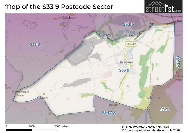
The S33 9 Postcode shares a border with S32 1 (Hathersage), S33 0 (Bamford), S33 6 (Hope), S33 8 (Castleton) and SK17 8 (Tideswell, Dove Holes, Peak Dale).
The sector is within the post town of HOPE VALLEY.
S33 9 is a postcode sector within the S33 postcode district which is within the S Sheffield postcode area.
The Royal Mail delivery office for the S33 9 postal sector is the Bradwell Scale Payment Delivery Office.
The area of the S33 9 postcode sector is 5.13 square miles which is 13.28 square kilometres or 3,281.44 square acres.
Waterways within the S33 9 postcode sector include the River Noe, Bradwell Brook.

Map of the S33 9 Postcode Sector
Explore the S33 9 postcode sector by using our free interactive map.
| S | 3 | 3 | - | 9 | X | X |
| S | 3 | 3 | Space | 9 | Letter | Letter |
Official List of Streets
Bradwell (44 Streets)
Unofficial Streets or Alternative Spellings
Bamford
HOPE ROADHope
ECCLES LANECastleton
PINDALE ROADWeather Forecast for S33 9
Press Button to Show Forecast for Castleton Youth Hostel
| Time Period | Icon | Description | Temperature | Rain Probability | Wind |
|---|---|---|---|---|---|
| 09:00 to 12:00 | Cloudy | 5.0°C (feels like 2.0°C) | 9.00% | ENE 7 mph | |
| 12:00 to 15:00 | Overcast | 6.0°C (feels like 5.0°C) | 9.00% | ENE 4 mph | |
| 15:00 to 18:00 | Cloudy | 7.0°C (feels like 6.0°C) | 7.00% | E 4 mph | |
| 18:00 to 21:00 | Cloudy | 6.0°C (feels like 4.0°C) | 9.00% | E 7 mph | |
| 21:00 to 00:00 | Partly cloudy (night) | 3.0°C (feels like 0.0°C) | 4.00% | ENE 4 mph |
Press Button to Show Forecast for Castleton Youth Hostel
| Time Period | Icon | Description | Temperature | Rain Probability | Wind |
|---|---|---|---|---|---|
| 00:00 to 03:00 | Cloudy | 1.0°C (feels like 0.0°C) | 8.00% | NE 4 mph | |
| 03:00 to 06:00 | Cloudy | 1.0°C (feels like -1.0°C) | 10.00% | NE 4 mph | |
| 06:00 to 09:00 | Cloudy | 2.0°C (feels like 0.0°C) | 11.00% | NE 7 mph | |
| 09:00 to 12:00 | Cloudy | 6.0°C (feels like 3.0°C) | 10.00% | E 9 mph | |
| 12:00 to 15:00 | Cloudy | 8.0°C (feels like 5.0°C) | 17.00% | E 11 mph | |
| 15:00 to 18:00 | Cloudy | 8.0°C (feels like 5.0°C) | 20.00% | ENE 11 mph | |
| 18:00 to 21:00 | Cloudy | 7.0°C (feels like 4.0°C) | 18.00% | ENE 11 mph | |
| 21:00 to 00:00 | Cloudy | 5.0°C (feels like 1.0°C) | 16.00% | ENE 11 mph |
Press Button to Show Forecast for Castleton Youth Hostel
| Time Period | Icon | Description | Temperature | Rain Probability | Wind |
|---|---|---|---|---|---|
| 00:00 to 03:00 | Light rain | 4.0°C (feels like 0.0°C) | 45.00% | NE 11 mph | |
| 03:00 to 06:00 | Light rain | 4.0°C (feels like 0.0°C) | 48.00% | NE 11 mph | |
| 06:00 to 09:00 | Heavy rain | 5.0°C (feels like 1.0°C) | 73.00% | NE 13 mph | |
| 09:00 to 12:00 | Heavy rain | 6.0°C (feels like 2.0°C) | 77.00% | NE 11 mph | |
| 12:00 to 15:00 | Light rain | 7.0°C (feels like 4.0°C) | 56.00% | NNE 11 mph | |
| 15:00 to 18:00 | Light rain | 7.0°C (feels like 5.0°C) | 55.00% | N 11 mph | |
| 18:00 to 21:00 | Cloudy | 7.0°C (feels like 5.0°C) | 16.00% | N 9 mph | |
| 21:00 to 00:00 | Partly cloudy (night) | 5.0°C (feels like 3.0°C) | 8.00% | SSE 7 mph |
Schools and Places of Education Within the S33 9 Postcode Sector
Bradwell CofE (Controlled) Infant School
Voluntary controlled school
Church Street, Hope Valley, Derbyshire, S33 9HJ
Head: Mrs Rebecca Gordine
Ofsted Rating: Good
Inspection: 2022-07-19 (647 days ago)
Website: Visit Bradwell CofE (Controlled) Infant School Website
Phone: 01433620409
Number of Pupils: 36
House Prices in the S33 9 Postcode Sector
| Type of Property | 2018 Average | 2018 Sales | 2017 Average | 2017 Sales | 2016 Average | 2016 Sales | 2015 Average | 2015 Sales |
|---|---|---|---|---|---|---|---|---|
| Detached | £317,500 | 1 | £387,500 | 6 | £320,250 | 4 | £318,594 | 8 |
| Semi-Detached | £240,000 | 8 | £257,850 | 4 | £209,625 | 12 | £224,286 | 7 |
| Terraced | £192,300 | 10 | £180,488 | 8 | £200,333 | 6 | £181,494 | 8 |
| Flats | £0 | 0 | £159,500 | 1 | £0 | 0 | £0 | 0 |
Important Postcodes S33 9 in the Postcode Sector
S33 9JB is the postcode for Bradwell Junior School, Hugh Lane
| The S33 9 Sector is within these Local Authorities |
|
|---|---|
| The S33 9 Sector is within these Counties |
|
| The S33 9 Sector is within these Water Company Areas |
|