DE Postcode Area for the Derby Region
A wide range of spatial data has been analysed to present this overview. If you would like anything added, please contact us.
This section of the site is all about the DE Postcode area, also known as the Derby Postal Area. Explore links to the next level to learn more about specific postcode districts such as DE1.

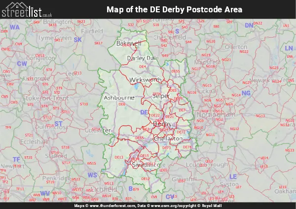
Map of the DE Derby Postcode Area
Explore the postcode area by using our interactive map.
Quick Facts about the DE Postcode
| Width from East to West | 25.77 mi |
| Height from North to South | 42.19 mi |
| Area of DE | 682.20 mi² |
| Maximum Width | 43.36 mi |
| Perimeter of Postcode Area | 203.58 mi |
| Number of Postcode Districts | 24 |
| Number of Postcode Sectors | 96 |
| Number of Post Towns | 11 |
| Number of Postcodes | 17,413 |
The DE postcode area represents a group of 23 postal districts in the Derby area of the United Kingdom. The area code stands for the letters d and e in DErby. The area has a population of 730,620 and covers an area of 1,766,908 hectares. Fun fact: 1.12% of the population of Great Britain lives in this area.
The postcode area falls within the following counties: Derbyshire (82.74%), Staffordshire (13.15%), Leicestershire (4.06%), Nottinghamshire (0.05%).
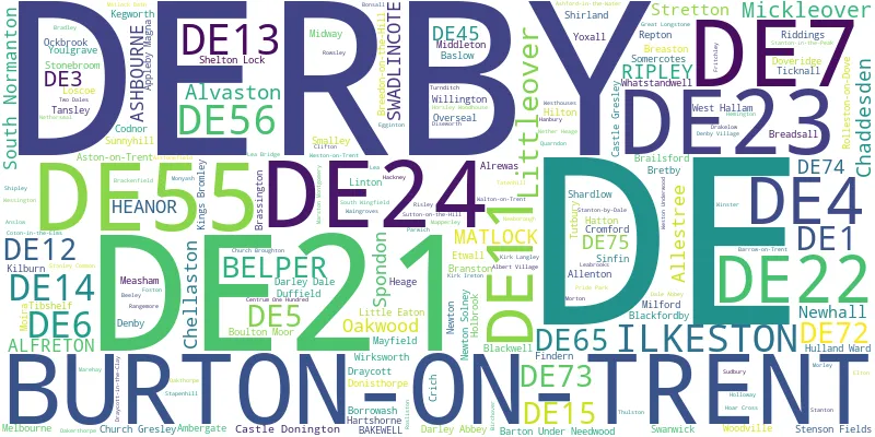
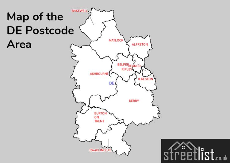
Post Towns and Postcode Districts
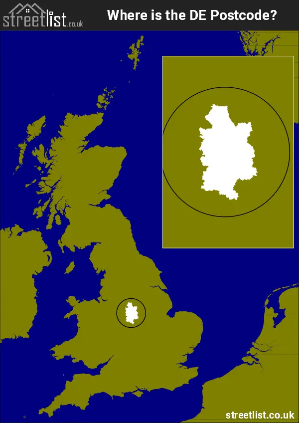
Where is the DE Postcode Area?
The DE Derby Postcode is in the East Midlands of England.. The postal area borders the following neighbouring postal areas: CV - Coventry, LE - Leicester, B - Birmingham, WS - Walsall, ST - Stoke-on-Trent, SK - Stockport, NG - Nottingham and S - Sheffield, and is located inland.
How built up is the Postcode Area?
I've calculated the total area covered by building footprints within the postcode area.
By analyzing this against the total area, I've determined the percentage of the area that's developed, this will give you an idea of how urban or rural the postcode region is.
The higher the percentage the more urban the area is. For example the least urban district is DE45 and the most urban is DE1.
| Postcode District | Total Area (m²) | Footprint Area (m²) | Built Percentage % |
|---|---|---|---|
| DE45 | 128,954,436 | 908,753 | 0.70% |
| DE6 | 413,682,824 | 3,388,121 | 0.82% |
| DE4 | 192,172,201 | 2,535,766 | 1.32% |
| DE73 | 70,821,404 | 1,185,645 | 1.67% |
| DE12 | 102,697,793 | 1,782,845 | 1.74% |
| DE13 | 155,676,556 | 3,108,878 | 2.00% |
| DE72 | 60,417,965 | 1,308,317 | 2.17% |
| DE65 | 95,666,073 | 2,122,829 | 2.22% |
| DE56 | 95,050,351 | 2,396,430 | 2.52% |
| DE15 | 34,323,047 | 1,141,729 | 3.33% |
| DE74 | 45,851,213 | 1,765,581 | 3.85% |
| DE55 | 88,226,733 | 3,678,012 | 4.17% |
| DE5 | 31,041,505 | 1,433,938 | 4.62% |
| DE7 | 58,749,401 | 2,825,324 | 4.81% |
| DE22 | 36,802,798 | 2,176,298 | 5.91% |
| DE11 | 36,880,448 | 2,280,812 | 6.18% |
| DE21 | 43,391,106 | 3,051,743 | 7.03% |
| DE75 | 13,069,947 | 929,951 | 7.12% |
| DE3 | 11,700,723 | 845,056 | 7.22% |
| DE14 | 15,290,526 | 2,350,970 | 15.38% |
| DE24 | 18,773,448 | 2,915,931 | 15.53% |
| DE23 | 13,649,609 | 2,199,996 | 16.12% |
| DE1 | 4,021,521 | 917,553 | 22.82% |
| Total | 1,766,911,628 (m²) | 47,250,478 (m²) | 2.67% |
A map showing the boundary of DE in relation to other areas
There are 13 towns within the Derby postcode area.
| Unit | Area² |
|---|---|
| Hectares | 1,766,908² |
| Miles | 6,822² |
| Feet | 190,188,210,212² |
| Kilometres | 17,669² |
Postal Delivery Offices Serving the Postcode Area
- Alfreton Delivery Office
- Ashbourne Delivery Office
- Bakewell Delivery Office
- Belper Delivery Office
- Burton On Trent Delivery Office
- Castle Delivery Office Nington Scale Payment Delivery Office
- Derby Provincial Delivery Office
- Derby Town Delivery Office
- Hatton Delivery Office
- Heanor Delivery Office
- Ilkeston Delivery Office
- Kegworth Scale Payment Delivery Office
- Matlock Delivery Office
- Ripley (de) Delivery Office
- Swadlincote Delivery Office
Tourist Attractions within the Area
We found 16 visitor attractions within the Derby postcode area
| Sudbury Hall |
|---|
| Historic Properties |
| Historic House / House and Garden / Palace |
| View Sudbury Hall on Google Maps |
| Tissington Hall |
| Historic Properties |
| Historic House / House and Garden / Palace |
| View Tissington Hall on Google Maps |
| National Memorial Arboretum |
| Visitor Centres |
| Heritage / Visitor Centre |
| View National Memorial Arboretum on Google Maps |
| Caudwell's Mill and Craft Centre |
| Workplace |
| Industrial / Craft Workplace |
| View Caudwell's Mill and Craft Centre on Google Maps |
| Chatsworth |
| Historic Properties |
| Historic House / House and Garden / Palace |
| View Chatsworth on Google Maps |
| Claymills Victorian Pumping Station |
| Historic Properties |
| Other Historic Property |
| View Claymills Victorian Pumping Station on Google Maps |
| Conkers |
| Leisure / Theme Parks |
| Leisure / Theme Park |
| View Conkers on Google Maps |
| Kedleston Hall |
| Historic Properties |
| Historic House / House and Garden / Palace |
| View Kedleston Hall on Google Maps |
| Strutt's North Mill |
| Museums & Art Galleries |
| Museum and / or Art Gallery |
| View Strutt's North Mill on Google Maps |
| Pickford's House Museum |
| Historic Properties |
| Historic House / House and Garden / Palace |
| View Pickford's House Museum on Google Maps |
| Heage Windmill |
| Visitor Centres |
| Heritage / Visitor Centre |
| View Heage Windmill on Google Maps |
| Calke Abbey |
| Historic Properties |
| Historic House / House and Garden / Palace |
| View Calke Abbey on Google Maps |
| Wingfield Manor |
| Historic Properties |
| Historic House / House and Garden / Palace |
| View Wingfield Manor on Google Maps |
| Alfreton and District Heritage Centre |
| Visitor Centres |
| Heritage / Visitor Centre |
| View Alfreton and District Heritage Centre on Google Maps |
| The Station |
| Visitor Centres |
| Heritage / Visitor Centre |
| View The Station on Google Maps |
| Shardlow Heritage Centre |
| Visitor Centres |
| Heritage / Visitor Centre |
| View Shardlow Heritage Centre on Google Maps |
Councils with Postcodes the Area
Towns and Villages within the Area
- Acresford - village
- Alderwasley - village
- Alfreton - town
- Alrewas - village
- Alstonefield - village
- Ambergate - village
- Anslow - village
- Appleby Magna - village
- Ashbourne - town
- Ashford in the Water - village
- Aston-on-Trent - village
- Atlow - otherSettlement
- Bakewell - town
- Bargate - village
- Barrow upon Trent - village
- Barton Gate - village
- Barton Turn - village
- Barton-under-Needwood - village
- Baslow - village
- Beeley - village
- Belper - town
- Birchover - village
- Blackbrook - village
- Blackfordby - village
- Blackwell - village
- Bolehill - village
- Bonsall - village
- Borrowash - village
- Boylestone - village
- Brackenfield - village
- Brailsford - village
- Brassington - village
- Breadsall - village
- Breaston - village
- Breedon on the Hill - village
- Bretby - village
- Bullbridge - village
- Burnaston - village
- Burton upon Trent - town
- Carsington - village
- Castle Donington - village
- Castle Gresley - village
- Chilcote - village
- Church Broughton - village
- Clifton - village
- Coton in the Elms - village
- Cowers Lane - village
- Coxbench - village
- Crich - village
- Cromford - village
- Dale Abbey - village
- Darley Bridge - village
- Darley Dale - town
- Denby Bottles - village
- Denby Common - village
- Denby Village - village
- Derby - city
- Diseworth - village
- Donisthorpe - village
- Doveridge - village
- Draycott - village
- Draycott in the Clay - village
- Ednaston - village
- Egginton - village
- Ellastone - village
- Elton - village
- Elvaston - village
- Etwall - village
- Fauld - village
- Fenny Bentley - village
- Findern - village
- Foston - village
- Fritchley - village
- Great Longstone - village
- Hanbury - village
- Hanbury Woodend - village
- Hartshorne - village
- Hatton - village
- Hazelwood - village
- Heage - village
- Heanor - town
- Hemington - village
- High Cross Bank - village
- Higham - village
- Hilcote - village
- Hilton - village
- Hoar Cross - village
- Hognaston - village
- Holbrook - village
- Hollington - village
- Holloway - village
- Horsley - village
- Horsley Woodhouse - village
- Hulland Village - village
- Hulland Ward - village
- Idridgehay - village
- Ilkeston - town
- Kegworth - village
- Kilburn - village
- King's Bromley - village
- King's Newton - village
- Kirk Ireton - village
- Kirk Langley - village
- Kniveton - village
- Langley Common - village
- Lea - village
- Leabrooks - village
- Linton - village
- Little Eaton - village
- Lockington - village
- Longford - village
- Lower Kilburn - village
- Lullington - village
- Lumsdale - village
- Mackworth - village
- Makeney - village
- Mapperley - village
- Marston Montgomery - village
- Matlock - town
- Matlock Bath - village
- Mayfield - village
- Measham - village
- Melbourne - village
- Middleton - village
- Milford - village
- Moira - village
- Monyash - village
- Morley - village
- Morton - village
- Mount Pleasant - village
- Mugginton - village
- Nether Heage - village
- Netherseal - village
- Newborough - village
- Newton - village
- Newton Solney - village
- Oaker - village
- Oakerthorpe - village
- Oakthorpe - village
- Ockbrook - village
- Over Haddon - village
- Overseal - village
- Parwich - village
- Pentrich - village
- Pilsley - village
- Pye Bridge - village
- Quarndon - village
- Ratcliffe on Soar - village
- Rawson Green - village
- Repton - village
- Riddings - village
- Ridgeway - village
- Ripley - town
- Risley - village
- Rodsley - otherSettlement
- Rolleston on Dove - village
- Rosliston - village
- Roston - village
- Rowsley - village
- Sandiacre - town
- Scropton - village
- Shardlow - village
- Shipley - village
- Shirland - village
- Shirley - village
- Short Heath - village
- Smalley - village
- Snarestone - village
- Somercotes - Settlement
- South Normanton - village
- South Wingfield - village
- Spring Cottage - village
- Stanhope Bretby - village
- Stanley - village
- Stanley Common - village
- Stanton - village
- Stanton - village
- Stanton by Bridge - village
- Stanton in Peak - village
- Stanton-by-Dale - village
- Starkholmes - village
- Stonebroom - village
- Stretton - village
- Stretton - village
- Sudbury - village
- Sutton Bonington - village
- Swadlincote - town
- Swanwick - village
- Swarkestone - village
- Tansley - village
- Tatenhill - village
- Thorpe - village
- Thulston - village
- Tibshelf - village
- Ticknall - village
- Tonge - village
- Turnditch - village
- Tutbury - village
- Upper Hackney - village
- Walton-on-Trent - village
- Weaverslake - village
- Wensley - village
- Wessington - village
- West Hallam - village
- Westhouses - village
- Weston Underwood - village
- Weston-on-Trent - village
- Whatstandwell - village
- Willington - village
- Wilson - village
- Winster - village
- Wirksworth - town
- Woodhouses - village
- Woodville - village
- Woolley Moor - village
- Wychnor - village
- Yeaveley - village
- Youlgreave / Youlgrave - village
- Yoxall - village