CV Postcode Area for the Coventry Region
A wide range of spatial data has been analysed to present this overview. If you would like anything added, please contact us.
This section of the site is all about the CV Postcode area, also known as the Coventry Postal Area. Explore links to the next level to learn more about specific postcode districts such as CV1.
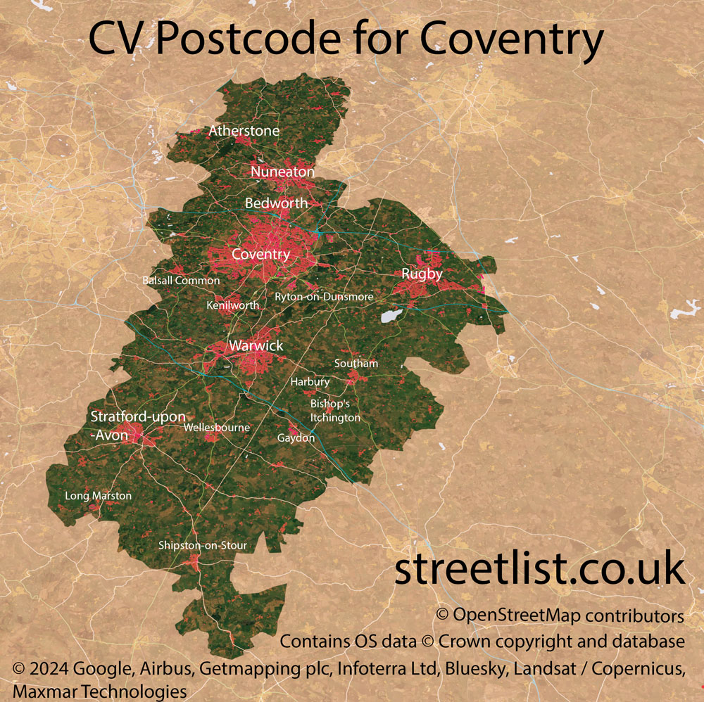
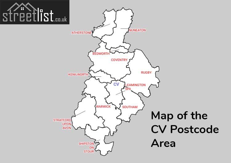
Map of the CV Postcode for Coventry
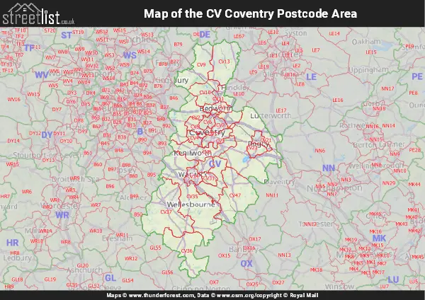
Map of the CV Coventry Postcode Area
Explore the postcode area by using our interactive map.
Quick Facts about the CV Postcode
| Width from East to West | 29.33 mi |
| Height from North to South | 49.19 mi |
| Area of CV | 700.24 mi² |
| Maximum Width | 49.60 mi |
| Perimeter of Postcode Area | 215.49 mi |
| Number of Postcode Districts | 24 |
| Number of Postcode Sectors | 105 |
| Number of Post Towns | 11 |
| Number of Postcodes | 20,551 |
The CV postcode area represents a group of 24 postal districts in the Coventry area of the United Kingdom. The area code stands for the letters c and v in CoVentry. The area has a population of 821,807 and covers an area of 1,813,622 hectares. Fun fact: 1.26% of the population of Great Britain lives in this area.
The postcode area falls within the following counties: Warwickshire (63.34%), West Midlands (34.08%), Leicestershire (1.91%), Northamptonshire (0.49%), Worcestershire (0.17%).
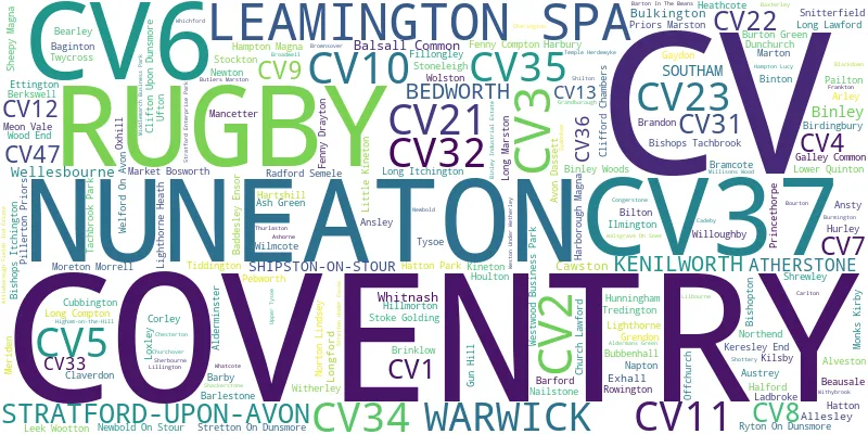
Post Towns and Postcode Districts
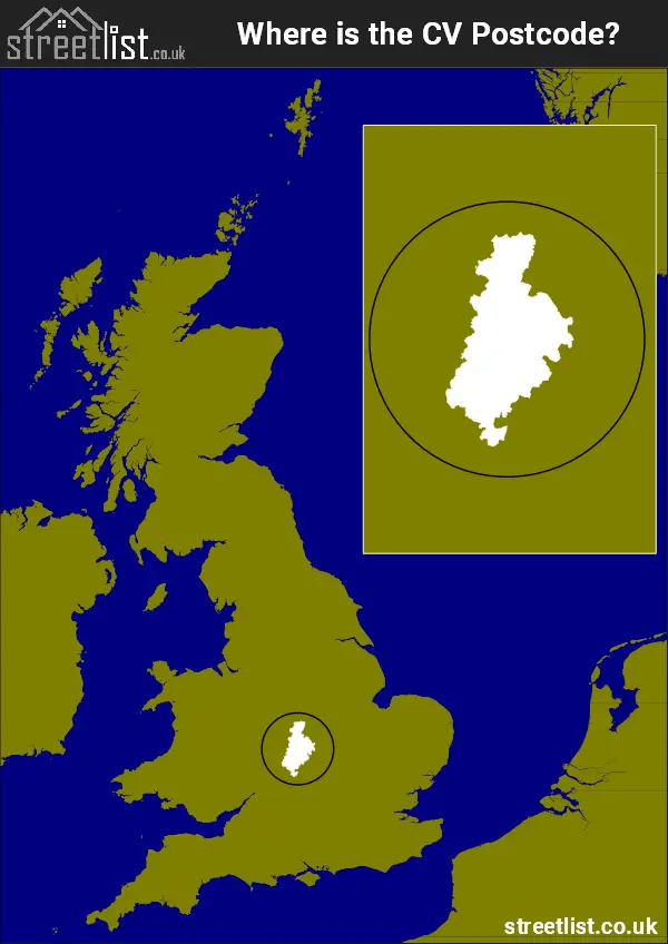
Where is the CV Postcode Area?
The Coventry CV Postcode is in the West Midlands Region.. The postal area borders the following neighbouring postal areas: DE - Derby, LE - Leicester, B - Birmingham, WR - Worcester, GL - Gloucester, OX - Oxford and NN - Northampton, and is located inland.
How built up is the Postcode Area?
I've calculated the total area covered by building footprints within the postcode area.
By analyzing this against the total area, I've determined the percentage of the area that's developed, this will give you an idea of how urban or rural the postcode region is.
The higher the percentage the more urban the area is. For example the least urban district is CV36 and the most urban is CV1.
| Postcode District | Total Area (m²) | Footprint Area (m²) | Built Percentage % |
|---|---|---|---|
| CV36 | 123,245,225 | 911,431 | 0.74% |
| CV13 | 109,673,325 | 1,035,220 | 0.94% |
| CV33 | 68,387,321 | 695,658 | 1.02% |
| CV47 | 151,323,339 | 1,577,509 | 1.04% |
| CV23 | 252,479,531 | 2,734,031 | 1.08% |
| CV35 | 245,594,665 | 2,724,730 | 1.11% |
| CV37 | 203,633,665 | 3,334,444 | 1.64% |
| CV9 | 107,534,702 | 1,834,674 | 1.71% |
| CV7 | 124,433,785 | 2,460,910 | 1.98% |
| CV8 | 88,855,530 | 2,168,260 | 2.44% |
| CV10 | 59,571,291 | 2,431,397 | 4.08% |
| CV12 | 25,124,206 | 1,309,841 | 5.21% |
| CV32 | 22,473,240 | 1,453,362 | 6.47% |
| CV31 | 18,240,812 | 1,360,117 | 7.46% |
| CV22 | 21,450,621 | 1,737,251 | 8.10% |
| CV11 | 25,749,207 | 2,131,116 | 8.28% |
| CV34 | 23,587,503 | 2,044,205 | 8.67% |
| CV5 | 24,275,155 | 2,147,691 | 8.85% |
| CV3 | 34,752,173 | 3,206,704 | 9.23% |
| CV4 | 17,633,430 | 1,889,659 | 10.72% |
| CV2 | 21,614,860 | 2,499,926 | 11.57% |
| CV21 | 18,775,118 | 2,298,914 | 12.24% |
| CV6 | 20,133,980 | 3,579,037 | 17.78% |
| CV1 | 5,082,487 | 1,335,805 | 26.28% |
| Total | 1,813,625,171 (m²) | 48,901,892 (m²) | 2.7% |
A map showing the boundary of CV in relation to other areas
There are 12 towns within the Coventry postcode area.
The Dawn of the CV Postcode Area: Automation and Adaptation
Coventry, a city nestled in the heart of England, has long been an emblem of modernity. But as the world propelled itself into the age of automation, even its postal system was not spared from this windswept wave of change.
Every day, a staggering 35 million letters traverse through the country's postal pathways, making the task of sorting and dispatching an immense challenge. Traditional manual methods, though reliable, were no longer sufficient. Hence, in response to this mounting mail, the Post Office introduced a new ally: the Postcode. As part of a nationwide scheme, the introduction of the CV postcode aimed to streamline the letter sorting process. The address, 71 Hertford Street, COVENTRY, CV1 1AA, encapsulated this novel transition.
The heart of this system was the machine. Sidney Creed, Coventry's head postmaster, unveiled in a meeting with Coventry Rotarians that by the following autumn, machinery would debut in Coventry for sorting second-class letters. This evolution of technology wasn't just a small step; it was a leap. Letters previously requiring manual sorting at numerous stages could soon be automatically sorted to postmen's delivery frames after merely two handlings. The aim? Simplification and efficiency.
However, it wasn't all smooth sailing. The machines, expected to be operational by the early autumn, came with their own set of tribulations. £2 million-worth of letter-sorting machinery was being installed in Midland sorting offices, including Coventry and Derby, but due to a national dispute with the Post Office Engineering Union over demands for a 35-hour work week, they remained dormant. The machinery, sensitive and intricate, required meticulous maintenance to function optimally.
The automation journey had been turbulent since its conception. Originally piloted in Norwich in 1959, the plan was for full automation by the end of the decade. However, hurdles persisted. Out of 80 earmarked sorting offices, only 18 had been transformed to accommodate the technological revolution. The success of the system hinged on one vital component: the mail bearing the postcode. As of then, only 45% of mail, mostly commercial, was properly marked with postcodes.
Yet, hope was on the horizon. Places like Nuneaton, Bedworth, and Atherstone were gearing up for their postcoding introductions. Residents and businesses were soon to be educated about their unique codes, urging them to utilize them on all letters. Despite the lack of machinery in Nuneaton, the Post Office remained optimistic about the utility of the code system, both for the immediate future and for potential mechanisation in the late 1970s. By then, the postcode was no longer a novelty; it was a necessity.
The CV postcode area wasn't just a series of alphanumeric characters; it represented a city's endeavour to embrace the future. Despite the challenges and teething problems, the vision was clear: a more efficient, automated postal system for Coventry and its environs. The Post Office's message was unmistakable: "Use of post codes becomes more important as the programme goes forward."
| Unit | Area² |
|---|---|
| Hectares | 1,813,622² |
| Miles | 7,002² |
| Feet | 195,216,458,458² |
| Kilometres | 18,136² |
Postal Delivery Offices Serving the Postcode Area
- Atherstone Delivery Office
- Bedworth Delivery Office
- Bishops Itchington Scale Payment Delivery Office
- Brinklow (cv) Scale Payment Delivery Office
- Bubbenhall Scale Payment Delivery Office
- Coventry City Delivery Office
- Coventry East Delivery Office
- Coventry South Delivery Office
- Coventry West Delivery Office
- Fillongley Scale Payment Delivery Office
- Gun Hill Scale Payment Delivery Office
- Harbury Scale Payment Delivery Office
- Kenilworth Delivery Office
- Keresley End Scale Payment Delivery Office
- Kineton Scale Payment Delivery Office
- Leamington Spa Delivery Office
- Lighthorne Heath Scale Payment Delivery Office
- Lighthorne Scale Payment Delivery Office
- Long Compton Scale Payment Delivery Office
- Lower Quinton Scale Payment Delivery Office
- Market Bosworth Scale Payment Delivery Office
- Meriden Scale Payment Delivery Office
- Monks Kirby Scale Payment Delivery Office
- Nuneaton Delivery Office
- Rugby Delivery Office
- Southam Delivery Office
- Stoke Golding Scale Payment Delivery Office
- Stratford Upon Avon Delivery Office
- Tysoe Scale Payment Delivery Office
- Warwick Delivery Office
- Whichford Scale Payment Delivery Office
Tourist Attractions within the Area
We found 19 visitor attractions within the Coventry postcode area
| Mary Arden's Farm |
|---|
| Historic Properties |
| Historic House / House and Garden / Palace |
| View Mary Arden's Farm on Google Maps |
| Anne Hathaway's Cottage |
| Historic Properties |
| Historic House / House and Garden / Palace |
| View Anne Hathaway's Cottage on Google Maps |
| Hall's Croft |
| Historic Properties |
| Historic House / House and Garden / Palace |
| View Hall's Croft on Google Maps |
| Shakespeare's Birthplace |
| Historic Properties |
| Historic House / House and Garden / Palace |
| View Shakespeare's Birthplace on Google Maps |
| Nash's House & New Place |
| Historic Properties |
| Historic House / House and Garden / Palace |
| View Nash's House & New Place on Google Maps |
| Harvard House & The Museum of British Pewter |
| Historic Properties |
| Historic House / House and Garden / Palace |
| View Harvard House & The Museum of British Pewter on Google Maps |
| St Laurence Church |
| Places of Worship |
| Place of Worship (still in use) |
| View St Laurence Church on Google Maps |
| Charlecote Park |
| Historic Properties |
| Historic House / House and Garden / Palace |
| View Charlecote Park on Google Maps |
| Wellesbourne Wartime Museum |
| Museums & Art Galleries |
| Museum and / or Art Gallery |
| View Wellesbourne Wartime Museum on Google Maps |
| Kenilworth Castle & Elizabethan Garden |
| Historic Properties |
| Castle / Fort |
| View Kenilworth Castle & Elizabethan Garden on Google Maps |
| Kenilworth Abbey Barn Museum |
| Museums & Art Galleries |
| Museum and / or Art Gallery |
| View Kenilworth Abbey Barn Museum on Google Maps |
| Redwings Oxhill Rescue Centre |
| Farms |
| Farm / Rare Breeds / Farm Animals |
| View Redwings Oxhill Rescue Centre on Google Maps |
| Coventry Transport Museum |
| Museums & Art Galleries |
| Museum and / or Art Gallery |
| View Coventry Transport Museum on Google Maps |
| St Mary's Guildhall |
| Historic Properties |
| Other Historic Property |
| View St Mary's Guildhall on Google Maps |
| Ryton Pools Country Parks |
| Country Parks |
| Country Park |
| View Ryton Pools Country Parks on Google Maps |
| Burton Dassett Country Park |
| Country Parks |
| Country Park |
| View Burton Dassett Country Park on Google Maps |
| Ryton Gardens |
| Gardens |
| Garden |
| View Ryton Gardens on Google Maps |
| Bosworth Battlefield Heritage Centre |
| Museums & Art Galleries |
| Museum and / or Art Gallery |
| View Bosworth Battlefield Heritage Centre on Google Maps |
| Castle Mound |
| Historic Properties |
| Historic Monument / Archaeological Site |
| View Castle Mound on Google Maps |
Councils with Postcodes the Area
Towns and Villages within the Area
- Alderminster - village
- Alveston - village
- Ansley - village
- Ansty - village
- Armscote - village
- Ash Green - village
- Ashorne - village
- Atherstone - town
- Atherstone on Stour - village
- Austrey - village
- Avon Dassett - village
- Baddesley Ensor - village
- Baginton - village
- Balsall Common - Settlement
- Barby - village
- Barford - village
- Barlestone - village
- Barnacle - village
- Barton in the Beans - village
- Baxterley - village
- Bearley - village
- Beausale - village
- Bedworth - town
- Bedworth Woodlands - village
- Berkswell - village
- Bermuda - village
- Binley Woods - village
- Binton - village
- Birdingbury - village
- Bishop's Itchington - village
- Bishop's Tachbrook - village
- Blackdown - village
- Blackwell - village
- Bourton on Dunsmore - village
- Bramcote - village
- Brandon - village
- Bretford - village
- Brinklow - village
- Broadwell - village
- Bubbenhall - village
- Budbrooke - otherSettlement
- Bulkington - village
- Burmington - village
- Burton Green - village
- Burton Hastings - village
- Butlers Marston - village
- Cadeby - village
- Caldecote - village
- Carlton - village
- Carol Green - village
- Cawston - village
- Charlecote - village
- Cherington - village
- Church Lawford - village
- Churchover - village
- Claverdon - village
- Clifford Chambers - village
- Clifton upon Dunsmore - village
- Combrook - village
- Congerstone - village
- Corley - village
- Corley Ash - village
- Corley Moor - village
- Coventry - city
- Cubbington - village
- Dadlington - village
- Darlingscott - village
- Dunchurch - village
- Dunsmore Heath - otherSettlement
- Easenhall - village
- Eathorpe - village
- Eaves Green - village
- Ettington - village
- Fen End - village
- Fenny Compton - village
- Fenny Drayton - village
- Fillongley - village
- Five Ways - village
- Flecknoe - village
- Frankton - village
- Gaydon - village
- Goldicote - village
- Grandborough - village
- Great Wolford - village
- Grendon - village
- Halford - village
- Hampton Lucy - village
- Hampton Magna - village
- Hampton on the Hill - village
- Harborough Magna - village
- Harbury - village
- Hartshill - village
- Harvest Hill - village
- Hatton - village
- Hatton - village
- Hatton Green - village
- Hawkesbury - village
- Higham on the Hill - village
- Hill Top - village
- Hunningham - village
- Hurley - village
- Hurley Common - village
- Idlicote - village
- Ilmington - village
- Kenilworth - town
- Keresley Newlands - village
- Kilsby - village
- Kineton - village
- Kingsbury - village
- Knightcote - village
- Ladbroke - village
- Lawford Heath - village
- Leamington Hastings - village
- Leek Wootton - village
- Lighthorne - village
- Lighthorne Heath - village
- Lilbourne - village
- Little Kineton - village
- Little Shrewley - village
- Little Wolford - village
- Long Compton - village
- Long Itchington - village
- Long Lawford - village
- Long Marston - village
- Longbridge - village
- Lower Quinton - village
- Lower Tysoe - village
- Loxley - village
- Luddington - village
- Mancetter - village
- Market Bosworth - town
- Marton - village
- Meer End - village
- Meon Vale - village
- Meriden - village
- Middle Tysoe - village
- Millison's Wood - village
- Monks Kirby - village
- Moreton Morrell - village
- Moreton Paddox - village
- Nailstone - village
- Napton on the Hill - village
- Neal's Green - village
- New Arley - village
- Newbold-on-Stour - village
- Newton - village
- Northend - village
- Norton Lindsey - village
- Norton-Juxta-Twycross - village
- Nuneaton - town
- Offchurch - village
- Old Arley - village
- Oldwich Lane - otherSettlement
- Onley - village
- Orton-on-the-Hill - village
- Oxhill - village
- Pailton - village
- Pebworth - village
- Pillerton Hersey - village
- Pillerton Priors - village
- Princethorpe - village
- Priors Hardwick - village
- Priors Marston - village
- Radford Semele - village
- Radway - village
- Ratcliffe Culey - village
- Ridge Lane - village
- Rowington - village
- Rowington Green - village
- Royal Leamington Spa - town
- Rugby - town
- Ryton-on-Dunsmore - village
- Shackerstone - village
- Sheepy Magna - village
- Sheepy Parva - village
- Shenton - village
- Sherbourne - village
- Shilton - village
- Shipston-on-Stour - town
- Shrewley - village
- Sibson - village
- Snitterfield - village
- Southam - town
- Stockton - village
- Stoke Golding - village
- Stoneleigh - village
- Stourton - village
- Stratford-upon-Avon - town
- Stretton-on-Dunsmore - village
- Sutton Cheney - village
- Temple Herdewyke - village
- Thurlaston - village
- Tredington - village
- Twycross - village
- Ufton - village
- Upper Quinton - village
- Upper Tysoe - village
- Warwick - town
- Welford-on-Avon - village
- Wellesbourne - village
- Weston under Wetherley - village
- Weston-on-Avon - village
- Whatcote - village
- Whichford - village
- Whitnash - town
- Willoughby - village
- Wilmcote - village
- Witherley - village
- Withybrook - village
- Wolston - village
- Wood End - village
- Wood End - village
- Woolscott - otherSettlement
- Wormleighton - village