The CV35 postcode district is a postal district located in the CV Coventry postcode area with a population of 26,869 residents according to the 2021 England and Wales Census.
The area of the CV35 postcode district is 94.75 square miles which is 245.40 square kilometres or 60,640.52 acres.
Currently, the CV35 district has about 950 postcode units spread across 4 geographic postcode sectors.
Given that each sector allows for 400 unique postcode combinations, the district has a capacity of 1,600 postcodes. With 950 postcodes already in use, this leaves 650 units available.
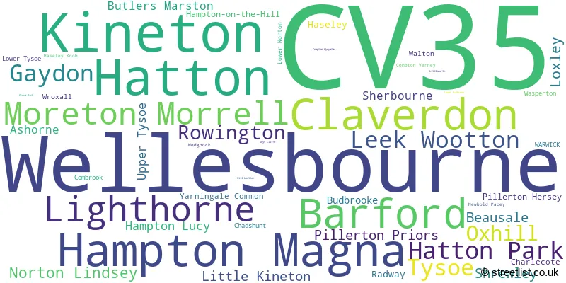
The largest settlement in the CV35 postal code is Wellesbourne followed by Kineton, and Barford.
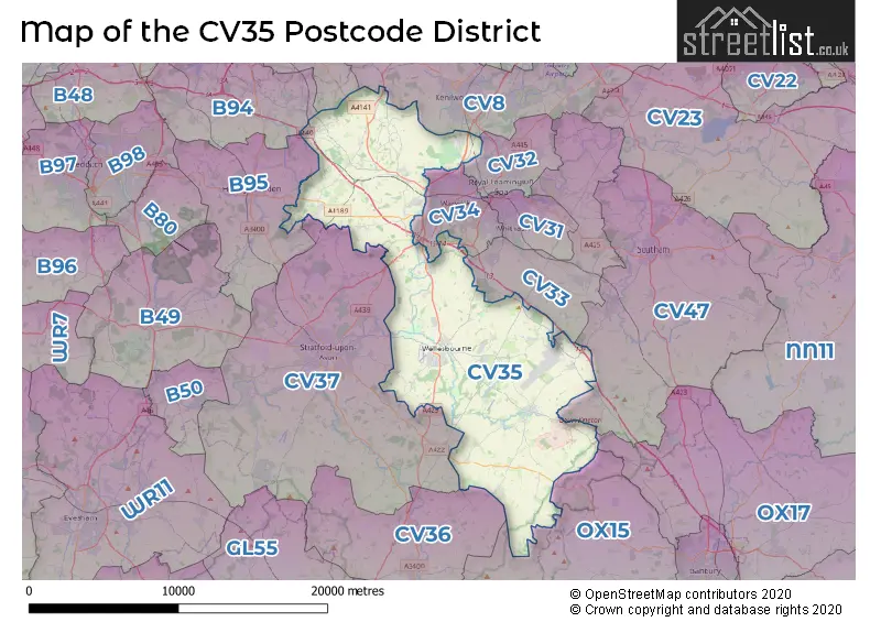
The CV35 Postcode shares a border with B95 (HENLEY-IN-ARDEN, Wootton Wawen, Ullenhall), CV32 (LEAMINGTON SPA, Cubbington, Blackdown), CV33 (Bishops Tachbrook, Harbury, Lighthorne Heath), CV34 (WARWICK, Heathcote, Tachbrook Park), CV37 (STRATFORD-UPON-AVON, Welford On Avon, Lower Quinton), CV47 (SOUTHAM, Bishops Itchington, Long Itchington), CV36 (SHIPSTON-ON-STOUR, Long Compton, Ilmington), OX15 (Bloxham, Bodicote, Hook Norton) and CV8 (KENILWORTH, Wolston, Ryton On Dunsmore).
The primary settlement in the CV35 postcode district is Wellesbourne, located in the county of Warwickshire in England. Other significant settlements in this district include Kineton, Gaydon, Hatton, Barford, and Claverdon. The most significant post town in this district is Warwick.
For the district CV35, we have data on 4 postcode sectors. Here's a breakdown: The sector CV35 0, covers Kineton and Lighthorne and Gaydon in Warwickshire. The sector CV35 7, covers Hatton and Hatton Park and Leek Wootton and Rowington in Warwickshire. The sector CV35 8, covers Hampton Magna and Claverdon and Barford in Warwickshire. The sector CV35 9, covers Wellesbourne and Moreton Morrell in Warwickshire.

Map of the CV35 Postcode District
Explore the CV35 postcode district by using our free interactive map.
When it comes to local government, postal geography often disregards political borders. However, for a breakdown in the CV35 District: the district mostly encompasses the Stratford-on-Avon District (607 postcodes), and finally, the Warwick District area (362 postcodes).
Weather Forecast for CV35
Press Button to Show Forecast for Wellesbourne
| Time Period | Icon | Description | Temperature | Rain Probability | Wind |
|---|---|---|---|---|---|
| 09:00 to 12:00 | Light rain | 7.0°C (feels like 3.0°C) | 52.00% | ENE 11 mph | |
| 12:00 to 15:00 | Overcast | 8.0°C (feels like 5.0°C) | 15.00% | NE 11 mph | |
| 15:00 to 18:00 | Overcast | 9.0°C (feels like 6.0°C) | 14.00% | NE 11 mph | |
| 18:00 to 21:00 | Overcast | 8.0°C (feels like 5.0°C) | 13.00% | NE 11 mph | |
| 21:00 to 00:00 | Overcast | 7.0°C (feels like 4.0°C) | 17.00% | NE 11 mph |
Press Button to Show Forecast for Wellesbourne
| Time Period | Icon | Description | Temperature | Rain Probability | Wind |
|---|---|---|---|---|---|
| 00:00 to 03:00 | Overcast | 6.0°C (feels like 3.0°C) | 50.00% | NNE 11 mph | |
| 03:00 to 06:00 | Light rain | 6.0°C (feels like 2.0°C) | 58.00% | NNE 13 mph | |
| 06:00 to 09:00 | Heavy rain | 6.0°C (feels like 2.0°C) | 82.00% | N 13 mph | |
| 09:00 to 12:00 | Heavy rain | 7.0°C (feels like 4.0°C) | 81.00% | NNW 11 mph | |
| 12:00 to 15:00 | Light rain | 9.0°C (feels like 6.0°C) | 53.00% | NW 9 mph | |
| 15:00 to 18:00 | Cloudy | 10.0°C (feels like 8.0°C) | 13.00% | WNW 9 mph | |
| 18:00 to 21:00 | Partly cloudy (day) | 10.0°C (feels like 8.0°C) | 5.00% | WSW 7 mph | |
| 21:00 to 00:00 | Clear night | 7.0°C (feels like 5.0°C) | 3.00% | SW 7 mph |
Press Button to Show Forecast for Wellesbourne
| Time Period | Icon | Description | Temperature | Rain Probability | Wind |
|---|---|---|---|---|---|
| 00:00 to 03:00 | Clear night | 5.0°C (feels like 3.0°C) | 1.00% | SW 7 mph | |
| 03:00 to 06:00 | Clear night | 4.0°C (feels like 2.0°C) | 1.00% | SSW 7 mph | |
| 06:00 to 09:00 | Sunny day | 6.0°C (feels like 3.0°C) | 1.00% | S 7 mph | |
| 09:00 to 12:00 | Partly cloudy (day) | 11.0°C (feels like 9.0°C) | 1.00% | S 11 mph | |
| 12:00 to 15:00 | Cloudy | 13.0°C (feels like 11.0°C) | 6.00% | S 13 mph | |
| 15:00 to 18:00 | Cloudy | 14.0°C (feels like 11.0°C) | 7.00% | S 13 mph | |
| 18:00 to 21:00 | Sunny day | 13.0°C (feels like 10.0°C) | 3.00% | S 11 mph | |
| 21:00 to 00:00 | Clear night | 9.0°C (feels like 7.0°C) | 3.00% | SSE 9 mph |
Press Button to Show Forecast for Wellesbourne
| Time Period | Icon | Description | Temperature | Rain Probability | Wind |
|---|---|---|---|---|---|
| 00:00 to 03:00 | Clear night | 8.0°C (feels like 5.0°C) | 3.00% | SE 9 mph | |
| 03:00 to 06:00 | Clear night | 7.0°C (feels like 4.0°C) | 2.00% | SE 9 mph | |
| 06:00 to 09:00 | Sunny day | 8.0°C (feels like 6.0°C) | 4.00% | SE 9 mph | |
| 09:00 to 12:00 | Sunny day | 13.0°C (feels like 11.0°C) | 6.00% | SE 11 mph | |
| 12:00 to 15:00 | Partly cloudy (day) | 16.0°C (feels like 13.0°C) | 9.00% | SE 13 mph | |
| 15:00 to 18:00 | Partly cloudy (day) | 16.0°C (feels like 14.0°C) | 9.00% | SE 11 mph | |
| 18:00 to 21:00 | Partly cloudy (day) | 15.0°C (feels like 13.0°C) | 5.00% | SE 9 mph | |
| 21:00 to 00:00 | Partly cloudy (night) | 12.0°C (feels like 10.0°C) | 5.00% | ESE 7 mph |
Where is the CV35 Postcode District?
According to the data provided, the postcode district CV35 is located in Warwick. Warwick is a district town which is near several other towns. Some of the nearby towns and their distances from Warwick are as follows: - Leamington Spa: 5.45 miles (North East) - Stratford-upon-Avon: 5.85 miles (South West) - Southam: 8.10 miles (East) - Kenilworth: 9.70 miles (North) - Shipston-on-Stour: 10.37 miles (South) - Henley-in-Arden: 10.38 miles (North West) - Alcester: 12.86 miles (West) Additionally, Warwick is located approximately 79.32 miles away from the centre of London.
The district is within the post town of WARWICK.
The sector has postcodes within the nation of England.
The CV35 Postcode District is in the Warwickshire region of Herefordshire, Worcestershire and Warwickshire within the West Midlands (England).
| Postcode Sector | Delivery Office |
|---|---|
| CV35 0 | Warwick Delivery Office |
| CV35 0 | Kineton Scale Payment Delivery Office |
| CV35 0 | Tysoe Scale Payment Delivery Office |
| CV35 0 | Lighthorne Scale Payment Delivery Office |
| CV35 7 | Warwick Delivery Office |
| CV35 8 | Warwick Delivery Office |
| CV35 9 | Warwick Delivery Office |
| C | V | 3 | 5 | - | X | X | X |
| C | V | 3 | 5 | Space | Numeric | Letter | Letter |
Tourist Attractions within the Postcode Area
We found 3 visitor attractions within the CV35 postcode area
| Charlecote Park |
|---|
| Historic Properties |
| Historic House / House and Garden / Palace |
| View Charlecote Park on Google Maps |
| Wellesbourne Wartime Museum |
| Museums & Art Galleries |
| Museum and / or Art Gallery |
| View Wellesbourne Wartime Museum on Google Maps |
| Redwings Oxhill Rescue Centre |
| Farms |
| Farm / Rare Breeds / Farm Animals |
| View Redwings Oxhill Rescue Centre on Google Maps |
Current Monthly Rental Prices
| # Bedrooms | Min Price | Max Price | Avg Price |
|---|---|---|---|
| £2,050 | £5,833 | £3,942 | |
| 1 | £800 | £800 | £800 |
| 2 | £800 | £2,250 | £1,177 |
| 3 | £1,400 | £2,750 | £2,075 |
| 4 | £2,200 | £2,400 | £2,267 |
| 5 | £2,500 | £6,500 | £4,500 |
| 6 | £2,650 | £2,650 | £2,650 |
Current House Prices
| # Bedrooms | Min Price | Max Price | Avg Price |
|---|---|---|---|
| £40,000 | £550,000 | £255,000 | |
| 1 | £170,000 | £230,000 | £199,600 |
| 2 | £120,000 | £550,000 | £310,087 |
| 3 | £142,500 | £1,995,000 | £469,863 |
| 4 | £360,000 | £2,000,000 | £674,915 |
| 5 | £405,000 | £4,750,000 | £1,035,264 |
| 6 | £600,000 | £4,750,000 | £1,535,909 |
| 7 | £650,000 | £4,500,000 | £2,609,000 |
| 8 | £2,250,000 | £5,000,000 | £3,300,000 |
| 10 | £1,175,000 | £1,175,000 | £1,175,000 |
Estate Agents who Operate in the CV35 District
| Logo | Name | Brand Name | Address | Contact Number | Total Properties |
|---|---|---|---|---|---|
 | Wellesbourne | Connells | Bridge Street, Wellesbourne, CV35 9QP | 01789 334670 | 28 |
 | Wellesbourne | Peter Clarke & Co | Warwick House Warwick Road, Wellesbourne, CV35 9ND | 01789 336132 | 13 |
 | Stratford Upon Avon | Knight Frank | Bridgeway, Stratford upon Avon, Warwickshire, CV37 6YX | 01789 335860 | 10 |
 | Birmingham | Savills New Homes | 55, Colmore Row, Birmingham, B3 2AA | 0121 387 6302 | 9 |
 | Kineton | Colebrook Seccombes | 2 Banbury Street, Kineton, CV35 0JS | 01926 353669 | 9 |
- Alveston
- Ashorne
- Baddesley Clinton
- Barford
- Barnmoor Green
- Beausale
- Brownlow Green
- Budbrooke
- Butlers Marston
- Chadshunt
- Charlecote
- Claverdon
- Combrook
- Finwood
- Five Ways
- Gaydon
- Goldicote
- Hampton Lucy
- Hampton Magna
- Hampton on the Hill
- Haseley Knob
- Haseley
- Hatton Green
- Hatton
- Hatton
- Heath End
- High Cross
- Kineton
- Kingswood
- Kington
- Leek Wootton
- Lighthorne Heath
- Lighthorne
- Little Kineton
- Little Shrewley
- Lower Norton
- Lower Tysoe
- Loxley
- Lye Green
- Middle Tysoe
- MOD Kineton
- Moreton Morrell
- Norton Lindsey
- Oxhill
- Pillerton Hersey
- Pillerton Priors
- Pinley Green
- Preston Bagot
- Radway
- Rowington Green
- Rowington
- Royal Leamington Spa
- Sherbourne
- Shrewley
- Tattle Bank
- Upper Tysoe
- Warwick
- Wasperton
- Wellesbourne
- Wroxall
| Type of Property | 2018 Average | 2018 Sales | 2017 Average | 2017 Sales | 2016 Average | 2016 Sales | 2015 Average | 2015 Sales |
|---|---|---|---|---|---|---|---|---|
| Detached | £503,512 | 244 | £488,091 | 277 | £508,108 | 329 | £467,582 | 228 |
| Semi-Detached | £297,871 | 105 | £322,891 | 103 | £261,774 | 157 | £291,855 | 91 |
| Terraced | £289,145 | 90 | £274,184 | 95 | £285,788 | 108 | £285,470 | 103 |
| Flats | £214,336 | 40 | £231,638 | 31 | £197,365 | 22 | £261,184 | 19 |