This section of the site is all about the LE Postcode area, also known as the Leicester Postal Area. Explore links to the next level to learn more about specific postcode districts such as LE1.
The LE postcode area represents a group of postal districts in the Leicester area of the United Kingdom. The area code LE stands for the letters l and e in LEicester. LE has a population of 985,795 and covers an area of 2,324,663 hectares. Fun fact: 1.52% of the population of Great Britain lives in this area.
The postcode area falls within the following counties: Leicestershire (93.48%), Rutland (4.31%), Nottinghamshire (1.21%), Northamptonshire (0.77%), Warwickshire (0.18%), Derbyshire (0.04%).
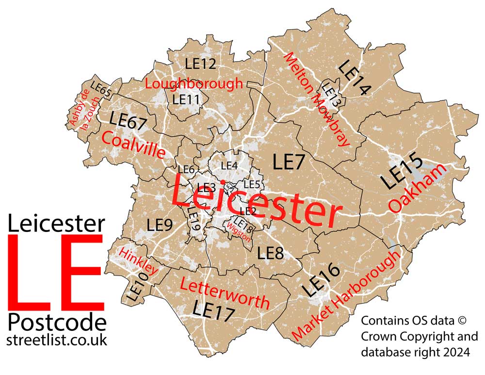
Post Towns and Postcode Districts for the LE Postcode
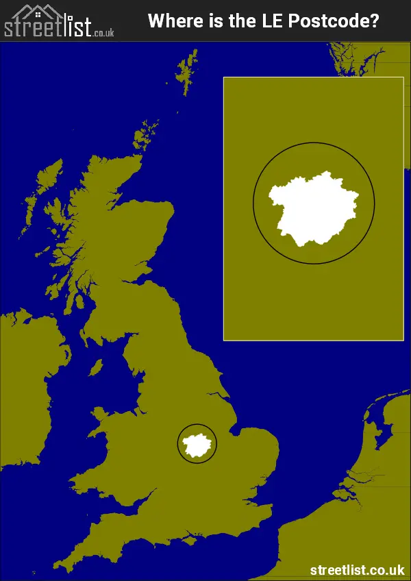
Where is the LE Postcode Area?
The LE Leicester Postcode is in the East Midlands of England. The postal area borders the following neighbouring postal areas: DE - Derby, CV - Coventry, PE - Peterborough, NN - Northampton and NG - Nottingham, and is located inland.
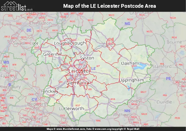
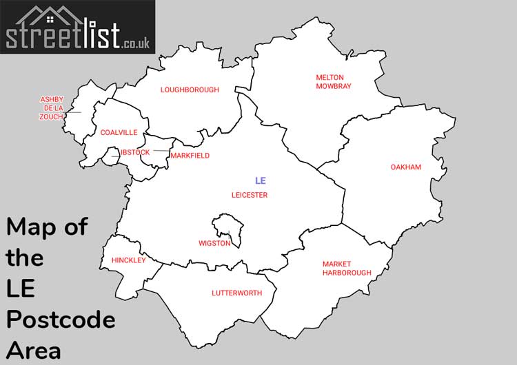
Map of the LE Leicester Postcode Area
Explore the LE Leicester postcode area by using our interactive map.
Postcode Districts within the LE Leicester Postcode Area
There are 21 postcode districts within the Leicester postcode area
A map showing the boundary of in relation to other areas
There are 13 towns within the Leicester postcode area.
| Unit | Area² |
|---|---|
| Hectares | 2,324,663² |
| Miles | 8,976² |
| Feet | 250,224,400,657² |
| Kilometres | 23,247² |
Postal Delivery Offices serving the LE Leicester Postcode Area
- Anstey Scale Payment Delivery Office
- Ashby-de-la-zouch Delivery Office
- Bagworth Scale Payment Delivery Office
- Barrow On Soar Scale Payment Delivery Office
- Belton (le) Scale Payment Delivery Office
- Billes Delivery Office N Scale Payment Delivery Office
- Blaby Scale Payment Delivery Office
- Broughton Astley Scale Payment Delivery Office
- Coalville Delivery Office
- Cosby Scale Payment Delivery Office
- Croft Scale Payment Delivery Office
- Earl Shilton Postal Delivery Office
- Fleckney Scale Payment Delivery Office
- Frisby On The Wreake Scale Payment Delivery Office
- Great Dalby Scale Payment Delivery Office
- Great Glen Scale Payment Delivery Office
- Groby Scale Payment Delivery Office
- Harby Scale Payment Delivery Office
- Hinckley Delivery Office
- Huncote Scale Payment Delivery Office
- Ibstock Scale Payment Delivery Office
- Kibworth Scale Payment Delivery Office
- Kirby Bellars Scale Payment Delivery Office
- Kirby Muxloe Scale Payment Delivery Office
- Leicester Central Delivery Office
- Leicester East Delivery Office
- Leicester North Delivery Office
- Leicester South Delivery Office
- Leicester South East Delivery Office
- Leicester West Delivery Office
- Loughborough Delivery Office
- Lutterworth Delivery Office
- Market Harborough Delivery Office
- Markfield Scale Payment Delivery Office
- Melton Mowbray Delivery Office
- Mountsorrel Scale Payment Delivery Office
- Newbold Ver Delivery Office N Scale Payment Delivery Office
- Normanton On Soar Scale Payment Delivery Office
- Oadby Delivery Office
- Oakham Delivery Office
- Quorn Scale Payment Delivery Office
- Ratby Scale Payment Delivery Office
- Rothley Scale Payment Delivery Office
- Sharnford Scale Payment Delivery Office
- Shepshed Delivery Office
- Sileby Scale Payment Delivery Office
- Somerby Scale Payment Delivery Office
- Stathern Scale Payment Delivery Office
- Stoney Stanton Scale Payment Delivery Office
- Sutton Bonington Scale Payment Delivery Office
- Swan House Delivery Office
- Syston Scale Payment Delivery Office
- Tilton On The Hill Scale Payment Delivery Office
- Wigston Delivery Office
- Wolvey Scale Payment Delivery Office
- Woodhouse Eaves Scale Payment Delivery Office
- Wymeswold Scale Payment Delivery Office
- Wymondham Scale Payment Delivery Office
Councils with Postcodes in LE
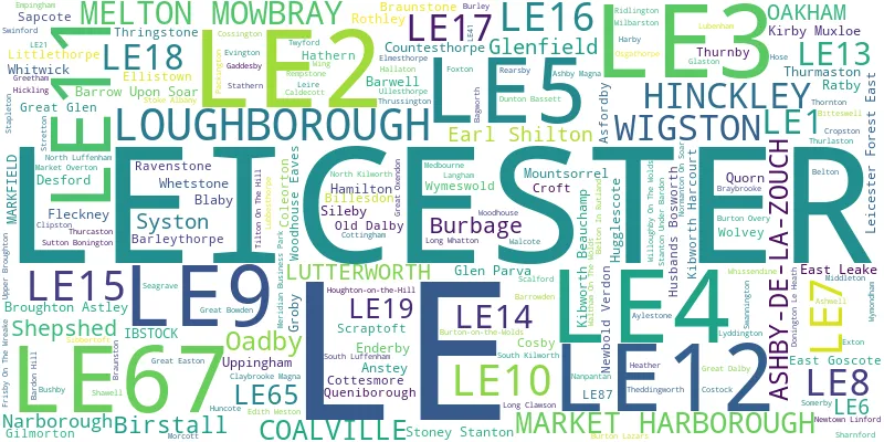
Towns and Villages within the LE Leicester Postcode Area
- Ab Kettleby - village
- Anstey - village
- Arnesby - village
- Arthingworth - village
- Asfordby - village
- Asfordby Hill - village
- Ashby Folville - village
- Ashby Magna - village
- Ashby Parva - village
- Ashby-de-la-Zouch - town
- Ashley - village
- Ashwell - village
- Aston Flamville - village
- Bagworth - village
- Bardon - village
- Barleythorpe - village
- Barrow - village
- Barrow upon Soar - village
- Barrowden - village
- Barsby - village
- Barwell - village
- Battram - village
- Belton - village
- Belton-in-Rutland - village
- Billesdon - village
- Birstall - village
- Bisbrooke - village
- Bitteswell - village
- Blaby - village
- Botcheston - village
- Braunston-in-Rutland - village
- Braybrooke - village
- Broughton Astley - village
- Bruntingthorpe - village
- Burley - village
- Burrough on the Hill - village
- Burton Lazars - village
- Burton on the Wolds - village
- Burton Overy - village
- Caldecott - village
- Catthorpe - village
- Church Langton - village
- Claybrooke Magna - village
- Claybrooke Parva - village
- Clipsham - village
- Clipston - village
- Coalville - town
- Cold Overton - village
- Coleorton - village
- Cosby - village
- Cossington - village
- Costock - village
- Cotesbach - village
- Cottesmore - village
- Cottingham - village
- Countesthorpe - village
- Croft - village
- Cropston - village
- Desford - village
- Dingley - village
- Donington le Heath - village
- Drayton - village
- Dunton Bassett - village
- Earl Shilton - town
- East Carlton - village
- East Farndon - village
- East Goscote - village
- East Langton - village
- East Leake - village
- Eastwell - village
- Edith Weston - village
- Edmondthorpe - village
- Egleton - village
- Ellistown - village
- Elmesthorpe - village
- Empingham - village
- Enderby - village
- Exton - village
- Fleckney - village
- Foxton - village
- Frisby on the Wreake - village
- Frolesworth - village
- Gartree - village
- Gaulby - village
- Gilmorton - village
- Glaston - village
- Glooston - village
- Goadby - village
- Goadby Marwood - village
- Great Bowden - village
- Great Dalby - village
- Great Easton - village
- Great Glen - village
- Great Oxendon - village
- Greetham - village
- Griffydam - village
- Grimston - village
- Groby - village
- Hallaton - village
- Harby - village
- Hathern - village
- Heather - village
- Hickling - village
- Hinckley - town
- Hoby - village
- Holwell - village
- Hose - village
- Hoton - village
- Houghton on the Hill - village
- Hugglescote - village
- Huncote - village
- Hungarton - village
- Husbands Bosworth - village
- Ibstock - town
- Keyham - village
- Kibworth Beauchamp - village
- Kibworth Harcourt - village
- Kilby - village
- Kimcote - village
- Kirby Bellars - village
- Kirby Muxloe - village
- Kirkby Mallory - village
- Knossington - village
- Langham - village
- Leesthorpe - otherSettlement
- Leicester - city
- Leicester Forest East - village
- Leicester Forest West - village
- Leire - village
- Little Dalby - otherSettlement
- Little Stretton - village
- Littlethorpe - village
- Long Clawson - village
- Long Whatton - village
- Loughborough - town
- Lubenham - village
- Lutterworth - town
- Lyddington - village
- Lyndon - village
- Manton - village
- Market Harborough - town
- Market Overton - village
- Markfield - village
- Marston Trussell - village
- Medbourne - village
- Melton Mowbray - town
- Middleton - village
- Morcott - village
- Mountsorrel - village
- Mowsley - village
- Narborough - village
- Nether Broughton - village
- Newbold - village
- Newbold Heath - village
- Newbold Verdon - village
- Newton Burgoland - village
- Newton Harcourt - village
- Newtown Linford - village
- Normanton le Heath - village
- Normanton on Soar - village
- North Kilworth - village
- North Luffenham - village
- Oadby - Settlement
- Oakham - town
- Old Dalby - village
- Osgathorpe - village
- Owston - village
- Packington - village
- Peatling Magna - village
- Peatling Parva - village
- Peckleton - village
- Peckleton Common - otherSettlement
- Pickwell - village
- Preston - village
- Queniborough - village
- Quorn / Quorndon - village
- Ragdale - village
- Ratby - village
- Ratcliffe on the Wreake - village
- Ravenstone - village
- Rearsby - village
- Rempstone - village
- Ridlington - village
- Rockingham - village
- Rotherby - village
- Rothley - village
- Saddington - village
- Saltby - village
- Sapcote - village
- Saxelbye - village
- Scalford - village
- Seagrave - village
- Seaton - village
- Sharnford - village
- Shawell - village
- Shearsby - village
- Shepshed - town
- Sibbertoft - village
- Sileby - village
- Skeffington - village
- Slawston - village
- Smeeton Westerby - village
- Smisby - village
- Somerby - village
- South Croxton - village
- South Kilworth - village
- South Luffenham - village
- Sproxton - village
- Stanford on Avon - otherSettlement
- Stanton under Bardon - village
- Stapleford - otherSettlement
- Stapleton - village
- Stathern - village
- Stoke Albany - village
- Stonesby - village
- Stoney Stanton - village
- Stoughton - village
- Stretton - village
- Sutton Bonington - village
- Swannington - village
- Swepstone - village
- Swinford - village
- Swithland - village
- Syston - town
- Theddingworth - village
- Thistleton - village
- Thornton - village
- Thorpe Arnold - village
- Thorpe Langton - village
- Thorpe Satchville - village
- Thringstone - village
- Thrussington - village
- Thurcaston - village
- Thurlaston - village
- Thurmaston - village
- Tilton on the Hill - village
- Tugby - village
- Tur Langton - village
- Twyford - village
- Ullesthorpe - village
- Upper Broughton - village
- Upper Bruntingthorpe - village
- Upper Hambleton - village
- Uppingham - town
- Wakerley - village
- Walcote - village
- Waltham on the Wolds - village
- Walton - village
- Walton on the Wolds - village
- Wanlip - village
- Weston by Welland - village
- Whetstone - village
- Whissendine - village
- Whitwick - village
- Wigston - Settlement
- Wilbarston - village
- Willoughby Waterleys - village
- Willoughby-on-the-Wolds - village
- Wing - village
- Wolvey - village
- Wolvey Heath - village
- Woodhouse - village
- Woodhouse Eaves - village
- Worthington - village
- Wykin - otherSettlement
- Wymeswold - village
- Wymondham - village
- Zouch - village