
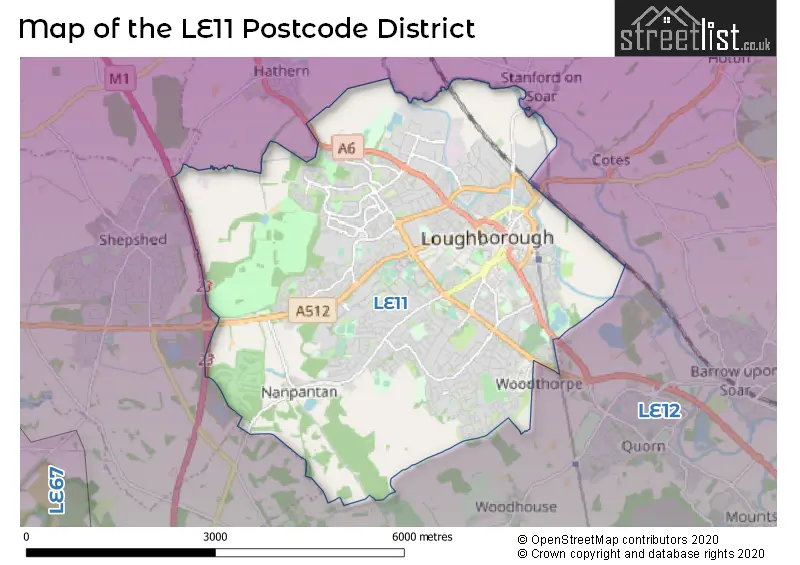
Map of the Postcode District
Explore the postcode district by using our interactive map.
Circles represent recorded crime; the larger the circle, the higher the crime rates.
Your support helps keep this site running!
If you enjoy using this website, consider buying me a coffee to help cover hosting costs.
The postcode district located in the LE Leicester postal area , LE11 has a population of 65,654 residents according to the 2021 England and Wales Census.
The area of the district is 11.89 square miles (30.79 square kilometers or 7,607.14 acres).
Where is the LE11 District?
To give you an idea where the district is located we have created the following table showing nearby towns.
Nearest Towns to LE11
| Town | Distance (miles) | Direction |
|---|---|---|
| Shepshed | 2.52 | W |
| Coalville | 6.28 | WSW |
| Syston | 8.09 | SE |
| Ibstock | 8.88 | SW |
| Long Eaton | 9.41 | N |
| Leicester | 10.04 | SSE |
| Ashby-de-la-Zouch | 10.21 | W |
| Sandiacre | 11.12 | NNW |
| Beeston | 11.15 | N |
| Stapleford | 11.43 | N |
| Market Bosworth | 12.14 | SW |
| West Bridgford | 12.46 | NNE |
| Cotgrave | 12.79 | NE |
| Nottingham | 13.54 | NNE |
| Earl Shilton | 13.66 | SSW |
| Swadlincote | 13.71 | W |
| Melton Mowbray | 14.37 | E |
| Ilkeston | 14.44 | NNW |
| Derby | 15.07 | NW |
The post town for this district is LOUGHBOROUGH.
Postcode Information for District LE11 (Total Geographical Postcodes: 1164)
| Location | Post Town | Sector | Number of Postcodes |
|---|---|---|---|
| LOUGHBOROUGH | LOUGHBOROUGH | LE11 2 | 302 |
| LOUGHBOROUGH | LOUGHBOROUGH | LE11 1 | 251 |
| LOUGHBOROUGH | LOUGHBOROUGH | LE11 3 | 231 |
| LOUGHBOROUGH | LOUGHBOROUGH | LE11 5 | 216 |
| LOUGHBOROUGH | LOUGHBOROUGH | LE11 4 | 152 |
| Nanpantan | LOUGHBOROUGH | LE11 3 | 12 |
Retail and Shopping in LE11
Street
Town
Locality
Number of Shops
Central Postcode
View on Google Maps
CHURCHGATE
LOUGHBOROUGH
49
LE11 1UE
View on Google Maps
MARKET STREET
LOUGHBOROUGH
49
LE11 3ER
View on Google Maps
ASHBY ROAD
LOUGHBOROUGH
42
LE11 3AA
View on Google Maps
BAXTER GATE
LOUGHBOROUGH
38
LE11 1TH
View on Google Maps
CARILLON COURT
LOUGHBOROUGH
32
LE11 3XA
View on Google Maps
NOTTINGHAM ROAD
LOUGHBOROUGH
30
LE11 1EU
View on Google Maps
THE RUSHES
LOUGHBOROUGH
29
LE11 5BE
View on Google Maps
HIGH STREET
LOUGHBOROUGH
27
LE11 2PY
View on Google Maps
LEICESTER ROAD
LOUGHBOROUGH
26
LE11 2AG
View on Google Maps
WARDS END
LOUGHBOROUGH
26
LE11 3HB
View on Google Maps
MARKET PLACE
LOUGHBOROUGH
25
LE11 3EB
View on Google Maps
DERBY ROAD
LOUGHBOROUGH
23
LE11 5HJ
View on Google Maps
PARK ROAD
LOUGHBOROUGH
20
LE11 2HJ
View on Google Maps
SWAN STREET
LOUGHBOROUGH
20
LE11 5BL
View on Google Maps
BIGGIN STREET
LOUGHBOROUGH
18
LE11 1UA
View on Google Maps
CATTLE MARKET
LOUGHBOROUGH
14
LE11 3DL
View on Google Maps
DEVONSHIRE SQUARE
LOUGHBOROUGH
13
LE11 3DW
View on Google Maps
BEDFORD SQUARE
LOUGHBOROUGH
12
LE11 2TP
View on Google Maps
SPARROW HILL
LOUGHBOROUGH
10
LE11 1BT
View on Google Maps
ASHBY SQUARE
LOUGHBOROUGH
9
LE11 5AA
View on Google Maps
MAXWELL DRIVE
LOUGHBOROUGH
9
LE11 4RZ
View on Google Maps
DERBY SQUARE
LOUGHBOROUGH
8
LE11 5AL
View on Google Maps
BROAD STREET
LOUGHBOROUGH
7
Coordinates unavailable
LING ROAD
LOUGHBOROUGH
6
LE11 2LW
View on Google Maps
WORDSWORTH ROAD
LOUGHBOROUGH
6
LE11 4LQ
View on Google Maps
| Street | Town | Locality | Number of Shops | Central Postcode | View on Google Maps |
|---|---|---|---|---|---|
| CHURCHGATE | LOUGHBOROUGH | 49 | LE11 1UE | View on Google Maps | |
| MARKET STREET | LOUGHBOROUGH | 49 | LE11 3ER | View on Google Maps | |
| ASHBY ROAD | LOUGHBOROUGH | 42 | LE11 3AA | View on Google Maps | |
| BAXTER GATE | LOUGHBOROUGH | 38 | LE11 1TH | View on Google Maps | |
| CARILLON COURT | LOUGHBOROUGH | 32 | LE11 3XA | View on Google Maps | |
| NOTTINGHAM ROAD | LOUGHBOROUGH | 30 | LE11 1EU | View on Google Maps | |
| THE RUSHES | LOUGHBOROUGH | 29 | LE11 5BE | View on Google Maps | |
| HIGH STREET | LOUGHBOROUGH | 27 | LE11 2PY | View on Google Maps | |
| LEICESTER ROAD | LOUGHBOROUGH | 26 | LE11 2AG | View on Google Maps | |
| WARDS END | LOUGHBOROUGH | 26 | LE11 3HB | View on Google Maps | |
| MARKET PLACE | LOUGHBOROUGH | 25 | LE11 3EB | View on Google Maps | |
| DERBY ROAD | LOUGHBOROUGH | 23 | LE11 5HJ | View on Google Maps | |
| PARK ROAD | LOUGHBOROUGH | 20 | LE11 2HJ | View on Google Maps | |
| SWAN STREET | LOUGHBOROUGH | 20 | LE11 5BL | View on Google Maps | |
| BIGGIN STREET | LOUGHBOROUGH | 18 | LE11 1UA | View on Google Maps | |
| CATTLE MARKET | LOUGHBOROUGH | 14 | LE11 3DL | View on Google Maps | |
| DEVONSHIRE SQUARE | LOUGHBOROUGH | 13 | LE11 3DW | View on Google Maps | |
| BEDFORD SQUARE | LOUGHBOROUGH | 12 | LE11 2TP | View on Google Maps | |
| SPARROW HILL | LOUGHBOROUGH | 10 | LE11 1BT | View on Google Maps | |
| ASHBY SQUARE | LOUGHBOROUGH | 9 | LE11 5AA | View on Google Maps | |
| MAXWELL DRIVE | LOUGHBOROUGH | 9 | LE11 4RZ | View on Google Maps | |
| DERBY SQUARE | LOUGHBOROUGH | 8 | LE11 5AL | View on Google Maps | |
| BROAD STREET | LOUGHBOROUGH | 7 | Coordinates unavailable | ||
| LING ROAD | LOUGHBOROUGH | 6 | LE11 2LW | View on Google Maps | |
| WORDSWORTH ROAD | LOUGHBOROUGH | 6 | LE11 4LQ | View on Google Maps |
The primary settlement in the LE11 postcode district is Loughborough, which is located in Leicestershire.
When it comes to local government, postal geography often disregards political borders. However, this district intersects the following councils: the district mostly encompasses the Charnwood District (B) area with a total of 1213 postal codes.
The LE11 postal code covers the settlement of LOUGHBOROUGH.
The LE11 Postcode shares a border with LE12 (Shepshed, Sileby, Mountsorrel).


Schools in the Sector
Cobden Primary School & Community Centre
Phase: Primary
Address: Cobden Street , Loughborough
Postcode: LE11 1AF
Headteacher: Mr Andrew Kitchen (Headteacher)
Ofsted Rating: Good
Trinity College
Phase: Not applicable
Address: Moor Lane , Loughborough
Postcode: LE11 1BA
Headteacher: Mrs Julie Saddler-Forman (Headteacher)
Ofsted Rating: Requires improvement
Rendell Primary School
Phase: Primary
Address: Rendell Street , Loughborough
Postcode: LE11 1LL
Headteacher: Mrs Karen Rixon (Headteacher)
Ofsted Rating: Good
Limehurst Academy
Phase: Secondary
Address: Bridge Street , Loughborough
Postcode: LE11 1NH
Headteacher: Mr Jonathan Mellor (Headteacher)
Ofsted Rating: Good
Sacred Heart Catholic Voluntary Academy
Phase: Primary
Address: Beacon Road , Loughborough
Postcode: LE11 2BG
Headteacher: Mrs Lisa Atkins (Headteacher)
Ofsted Rating: Good
Outwoods Edge Primary School
Phase: Primary
Address: 21 Redwood Road , Loughborough
Postcode: LE11 2LD
Headteacher: Mr Mark Wilson (Headteacher)
Ofsted Rating: Good
Beacon Academy
Phase: Primary
Address: Woodthorpe Road , Loughborough
Postcode: LE11 2NF
Headteacher: Mr Ben Kilgannon (Headteacher)
Ofsted Rating: Good
Woodbrook Vale School
Phase: Secondary
Address: Grasmere Road , Loughborough
Postcode: LE11 2ST
Headteacher: Mrs Rachael Fraser (Headteacher)
Ofsted Rating: Good
Sense College Loughborough
Phase: Not applicable
Address: Radmoor Road , Loughborough
Postcode: LE11 3BS
Headteacher: Mr Gary Hyndman (Principal)
Ofsted Rating: Good
Loughborough College
Phase: 16 plus
Address: Radmoor Road , Loughborough
Postcode: LE11 3BT
Headteacher: Mrs Heather Clarke (Principal)
Ofsted Rating: Good
Loughborough Church of England Primary School
Phase: Primary
Address: William Street , Loughborough
Postcode: LE11 3BY
Headteacher: Mrs Janine Stillwell (Headteacher)
Ofsted Rating: Good
ASPIRE: Lifeskills
Phase: Not applicable
Address: Town Hall Chambers , Town Hall Passage , Loughborough , Leicestershire
Postcode: LE11 3EB
Headteacher: Mrs VIVIENNE BOULTON ()
Ofsted Rating: Good
Mountfields Lodge School
Phase: Primary
Address: Epinal Way , Loughborough
Postcode: LE11 3GE
Headteacher: Mrs Iona Mock (Headteacher)
Ofsted Rating: Good
Holywell Primary School
Phase: Primary
Address: Berkeley Road , Loughborough
Postcode: LE11 3SJ
Headteacher: Mr Ed Petrie (Headteacher)
Ofsted Rating: Outstanding
Loughborough University
Phase: Not applicable
Address: Ashby Road , Loughborough
Postcode: LE11 3TU
Headteacher: Professor Nick Jennings (Vice Chancellor and President)
Ofsted Rating: Good
Nanpantan Hall Nurture Centre
Phase: Not applicable
Address: The Coach House , Nanpantan Road , Loughborough
Postcode: LE11 3YF
Headteacher: Mr John Furborough ()
Ofsted Rating: Requires improvement
Booth Wood Primary School
Phase: Primary
Address: Old Ashby Road , Loughborough
Postcode: LE11 4PG
Headteacher: Mrs Julie Harvey (Headteacher)
Ofsted Rating: Outstanding
Thorpe Acre Junior School
Phase: Primary
Address: Alan Moss Road , Loughborough
Postcode: LE11 4SQ
Headteacher: Ms Jo Beaumont (Headteacher)
Ofsted Rating: Good
Thorpe Acre Infant School
Phase: Primary
Address: Alan Moss Road , Loughborough
Postcode: LE11 4SQ
Headteacher: Ms Jo Beaumont (Headteacher)
Ofsted Rating: Good
Ashmount School
Phase: Not applicable
Address: Thorpe Hill , Loughborough
Postcode: LE11 4SQ
Headteacher: Mr David Deacon (Head Teacher)
Ofsted Rating: Outstanding
De Lisle College Loughborough Leicestershire
Phase: Secondary
Address: Thorpe Hill , Loughborough
Postcode: LE11 4SQ
Headteacher: Mr Chris Maher (Headteacher)
Ofsted Rating: Good
Charnwood College
Phase: Secondary
Address: Thorpe Hill , Loughborough
Postcode: LE11 4SQ
Headteacher: Mr Alastair O'Connor (Principal)
Ofsted Rating: Good
Stonebow Primary School Loughborough
Phase: Primary
Address: Stonebow Close , Loughborough
Postcode: LE11 4ZH
Headteacher: Mr Paul Brockless (Headteacher)
Ofsted Rating: Good
Saint Mary's Catholic Primary School, Loughborough
Phase: Primary
Address: Hastings Street , Loughborough
Postcode: LE11 5AX
Headteacher: Miss Priscilla Jordan (Headteacher)
Ofsted Rating: Good
Robert Bakewell Primary School
Phase: Primary
Address: Barsby Drive , Loughborough
Postcode: LE11 5UJ
Headteacher: Mr Jon Bishop (Headteacher)
Ofsted Rating: Good
Stations in the Sector
Loughborough
CRS Code: LBO
Operator: EM
Line: East Midland Main Line
Company: East Midlands Railway
Accessable Motorway Junctions
M1 J23A
Average Driving Time from within the district: 9.97
Average Driving Distance: 7.56
Number of Postcodes that can access the Motorway Junction: 1211
M1 J22
Average Driving Time from within the district: 10.18
Average Driving Distance: 7.65
Number of Postcodes that can access the Motorway Junction: 1211
M1 J24
Average Driving Time from within the district: 11.18
Average Driving Distance: 7.91
Number of Postcodes that can access the Motorway Junction: 1211
M1 J25
Average Driving Time from within the district: 15.05
Average Driving Distance: 12.09
Number of Postcodes that can access the Motorway Junction: 91
M1 J21A
Average Driving Time from within the district: 15.33
Average Driving Distance: 13.18
Number of Postcodes that can access the Motorway Junction: 1120
M1 J24A
Average Driving Time from within the district: 20.82
Average Driving Distance: 17.98
Number of Postcodes that can access the Motorway Junction: 1211
Weather Forecast for Loughborough
| Time Period | Icon | Description | Temperature | Rain Probability | Wind |
|---|---|---|---|---|---|
| 12:00 to 15:00 | Cloudy | 14.0°C (feels like 12.0°C) | 4.00% | WSW 9 mph | |
| 15:00 to 18:00 | Partly cloudy (day) | 15.0°C (feels like 14.0°C) | 12.00% | WNW 7 mph | |
| 18:00 to 21:00 | Clear night | 11.0°C (feels like 11.0°C) | 0.00% | SSW 2 mph | |
| 21:00 to 00:00 | Clear night | 10.0°C (feels like 9.0°C) | 0.00% | SSE 4 mph |
| Time Period | Icon | Description | Temperature | Rain Probability | Wind |
|---|---|---|---|---|---|
| 00:00 to 03:00 | Clear night | 9.0°C (feels like 8.0°C) | 0.00% | SSE 4 mph | |
| 03:00 to 06:00 | Cloudy | 8.0°C (feels like 7.0°C) | 3.00% | SSE 4 mph | |
| 06:00 to 09:00 | Cloudy | 8.0°C (feels like 7.0°C) | 6.00% | SSE 7 mph | |
| 09:00 to 12:00 | Cloudy | 10.0°C (feels like 9.0°C) | 7.00% | SSE 7 mph | |
| 12:00 to 15:00 | Cloudy | 14.0°C (feels like 12.0°C) | 3.00% | SSW 11 mph | |
| 15:00 to 18:00 | Cloudy | 15.0°C (feels like 13.0°C) | 4.00% | SSW 9 mph | |
| 18:00 to 21:00 | Cloudy | 13.0°C (feels like 11.0°C) | 4.00% | S 9 mph | |
| 21:00 to 00:00 | Clear night | 11.0°C (feels like 9.0°C) | 1.00% | S 9 mph |
| Time Period | Icon | Description | Temperature | Rain Probability | Wind |
|---|---|---|---|---|---|
| 00:00 to 03:00 | Clear night | 10.0°C (feels like 8.0°C) | 1.00% | SSE 9 mph | |
| 03:00 to 06:00 | Clear night | 10.0°C (feels like 8.0°C) | 1.00% | SSE 9 mph | |
| 06:00 to 09:00 | Clear night | 10.0°C (feels like 7.0°C) | 1.00% | SSE 11 mph | |
| 09:00 to 12:00 | Overcast | 11.0°C (feels like 9.0°C) | 7.00% | SSE 13 mph | |
| 12:00 to 15:00 | Overcast | 14.0°C (feels like 11.0°C) | 7.00% | S 16 mph | |
| 15:00 to 18:00 | Partly cloudy (day) | 15.0°C (feels like 13.0°C) | 1.00% | SSE 13 mph | |
| 18:00 to 21:00 | Overcast | 14.0°C (feels like 12.0°C) | 8.00% | SSE 13 mph | |
| 21:00 to 00:00 | Cloudy | 13.0°C (feels like 11.0°C) | 14.00% | SSE 13 mph |
| Time Period | Icon | Description | Temperature | Rain Probability | Wind |
|---|---|---|---|---|---|
| 00:00 to 03:00 | Cloudy | 14.0°C (feels like 11.0°C) | 22.00% | S 13 mph | |
| 03:00 to 06:00 | Overcast | 13.0°C (feels like 11.0°C) | 25.00% | S 11 mph | |
| 06:00 to 09:00 | Partly cloudy (night) | 11.0°C (feels like 9.0°C) | 12.00% | SSW 11 mph | |
| 09:00 to 12:00 | Partly cloudy (day) | 12.0°C (feels like 9.0°C) | 5.00% | SSW 11 mph | |
| 12:00 to 15:00 | Partly cloudy (day) | 13.0°C (feels like 11.0°C) | 13.00% | SSW 13 mph | |
| 15:00 to 18:00 | Light rain shower (day) | 13.0°C (feels like 10.0°C) | 38.00% | SSW 11 mph | |
| 18:00 to 21:00 | Clear night | 10.0°C (feels like 8.0°C) | 8.00% | SSW 9 mph | |
| 21:00 to 00:00 | Clear night | 9.0°C (feels like 7.0°C) | 5.00% | SSW 9 mph |
| Time Period | Icon | Description | Temperature | Rain Probability | Wind |
|---|---|---|---|---|---|
| 00:00 to 03:00 | Clear night | 8.0°C (feels like 6.0°C) | 3.00% | SW 11 mph | |
| 03:00 to 06:00 | Partly cloudy (night) | 8.0°C (feels like 5.0°C) | 3.00% | SW 11 mph | |
| 06:00 to 09:00 | Partly cloudy (night) | 8.0°C (feels like 5.0°C) | 7.00% | SW 11 mph | |
| 09:00 to 12:00 | Partly cloudy (day) | 10.0°C (feels like 7.0°C) | 9.00% | SW 11 mph | |
| 12:00 to 15:00 | Cloudy | 12.0°C (feels like 9.0°C) | 12.00% | SW 13 mph | |
| 15:00 to 18:00 | Cloudy | 12.0°C (feels like 10.0°C) | 14.00% | SW 13 mph | |
| 18:00 to 21:00 | Cloudy | 11.0°C (feels like 8.0°C) | 13.00% | SW 11 mph | |
| 21:00 to 00:00 | Clear night | 10.0°C (feels like 8.0°C) | 7.00% | SW 11 mph |
| Postal Sector | Delivery Office |
|---|---|
| LE11 1 | Loughborough Delivery Office |
| LE11 2 | Loughborough Delivery Office |
| LE11 3 | Loughborough Delivery Office |
| LE11 4 | Loughborough Delivery Office |
| LE11 5 | Loughborough Delivery Office |
| L | E | 1 | 1 | - | X | X | X |
| L | E | 1 | 1 | Space | Numeric | Letter | Letter |
Tourist Attractions
We found 2 visitor attractions.
| Charnwood Museum |
|---|
| Museums & Art Galleries |
| Museum and / or Art Gallery |
| View Charnwood Museum on Google Maps |
| Carillon and War Memorial Museum |
| Historic Properties |
| Historic Monument / Archaeological Site |
| View Carillon and War Memorial Museum on Google Maps |
Street List for the LE11 District
Current Monthly Rental Prices
| # Bedrooms | Min Price | Max Price | Avg Price |
|---|---|---|---|
| £700 | £1,400 | £894 | |
| 1 | £140 | £1,040 | £676 |
| 2 | £477 | £1,375 | £941 |
| 3 | £875 | £1,500 | £1,167 |
| 4 | £140 | £2,000 | £735 |
| 5 | £105 | £3,467 | £932 |
| 6 | £386 | £2,400 | £678 |
| 7 | £390 | £585 | £488 |
Current House Prices
| # Bedrooms | Min Price | Max Price | Avg Price |
|---|---|---|---|
| £33,800 | £1,000,000 | £208,971 | |
| 1 | £32,000 | £230,000 | £99,065 |
| 2 | £64,000 | £325,000 | £191,738 |
| 3 | £135,000 | £500,000 | £273,306 |
| 4 | £60,000 | £2,500,000 | £437,953 |
| 5 | £145,000 | £935,000 | £438,442 |
| 6 | £160,000 | £425,000 | £261,000 |
| 7 | £250,000 | £250,000 | £250,000 |
Estate Agents
| Logo | Name | Brand Name | Address | Contact Number |
|---|---|---|---|---|
 | Loughborough | loc8me | 3 Ashby Square, Loughborough, LE11 5AA | 01509 275497 |
 | Loughborough | Nick Humphreys | 39 Ashby Road, Loughborough, LE11 3AA | 01501 648992 |
 | Loughborough | William H. Brown | 22/23 Swan Street, Loughborough, LE11 5BL | 01509 275621 |
 | Loughborough | Newton Fallowell | 3 Swan Street, Loughborough, LE11 5BJ | 01509 275667 |
 | Loughborough | Your Move | 65-66 Baxter Gate, Loughborough, LE11 1TH | 01509 275628 |
Yearly House Price Averages for the District
| Type of Property | 2018 Average | 2018 Sales | 2017 Average | 2017 Sales | 2016 Average | 2016 Sales | 2015 Average | 2015 Sales |
|---|---|---|---|---|---|---|---|---|
| Detached | £297,056 | 240 | £299,874 | 264 | £278,164 | 278 | £266,157 | 246 |
| Semi-Detached | £194,346 | 378 | £184,163 | 300 | £173,576 | 262 | £160,848 | 264 |
| Terraced | £164,776 | 300 | £156,161 | 332 | £143,447 | 309 | £138,066 | 281 |
| Flats | £114,086 | 105 | £104,667 | 89 | £101,806 | 74 | £100,620 | 84 |