The LE12 postcode district is a postal district located in the LE Leicester postcode area with a population of 69,394 residents according to the 2021 England and Wales Census.
The area of the LE12 postcode district is 83.21 square miles which is 215.51 square kilometres or 53,254.18 acres.
Currently, the LE12 district has about 1509 postcode units spread across 5 geographic postcode sectors.
Given that each sector allows for 400 unique postcode combinations, the district has a capacity of 2,000 postcodes. With 1509 postcodes already in use, this leaves 491 units available.
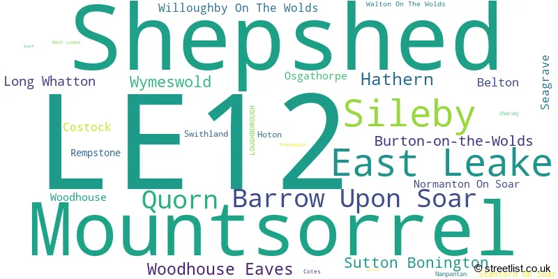
The largest settlement in the LE12 postal code is Shepshed followed by Sileby, and Mountsorrel.
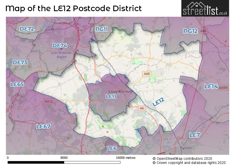
The LE12 Postcode shares a border with LE67 (COALVILLE, Whitwick, IBSTOCK), NG11 (NOTTINGHAM, Ruddington, Gotham), DE74 (Castle Donington, Kegworth, Diseworth), LE11 (LOUGHBOROUGH), LE7 (Syston, Anstey, Rothley), LE14 (Asfordby, Old Dalby, Long Clawson) and NG12 (Radcliffe-on-Trent, Keyworth, Cotgrave).
In the LE12 postcode district, the primary settlement is Loughborough, which is located in the county of Leicestershire. Other significant settlements in this district include Burton-on-the-Wolds, Hathern, Hoton, Long Whatton, Normanton On Soar, Prestwold, Stanford On Soar, Sutton Bonington, West Leake, Zouch, Costock, East Leake, Rempstone, Willoughby On The Wolds, Wymeswold, Mountsorrel, Seagrave, Sileby, Barrow Upon Soar, Quorn, Swithland, Walton On The Wolds, Woodhouse, Woodhouse Eaves, Woodthorpe, Belton, Charley, Nanpantan, Osgathorpe, and Shepshed. The most significant post town in this district is Loughborough.
For the district LE12, we have data on 5 postcode sectors. Here's a breakdown: The sector LE12 5, covers Hathern and Burton-On-The-Wolds and Long Whatton in Leicestershire. The sector LE12 5, covers Sutton Bonington in Nottinghamshire. The sector LE12 6, covers East Leake in Nottinghamshire. The sector LE12 6, covers Wymeswold in Leicestershire. The sector LE12 7, covers Mountsorrel and Sileby in Leicestershire. The sector LE12 8, covers Barrow Upon Soar and Quorn and Woodhouse Eaves in Leicestershire. The sector LE12 9, covers Shepshed in Leicestershire.

Map of the LE12 Postcode District
Explore the LE12 postcode district by using our free interactive map.
When it comes to local government, postal geography often disregards political borders. However, for a breakdown in the LE12 District: the district mostly encompasses the Charnwood District (B) (1200 postcodes), followed by the Rushcliffe District (B) area (293 postcodes), and finally, the North West Leicestershire District area (75 postcodes).
Recent House Sales in LE12
| Date | Price | Address |
|---|---|---|
| 13/10/2023 | £450,000 | Carisbrooke Road, Mountsorrel, Loughborough, LE12 7BR |
| 12/10/2023 | £530,000 | Brook Street, Wymeswold, Loughborough, LE12 6TT |
| 09/10/2023 | £157,000 | Weldon Avenue, Sileby, Loughborough, LE12 7NU |
| 09/10/2023 | £200,000 | Main Street, Sutton Bonington, Loughborough, LE12 5NE |
| 06/10/2023 | £425,000 | London Lane, Willoughby On The Wolds, Loughborough, LE12 6SX |
| 06/10/2023 | £370,000 | Hawley Close, East Leake, Loughborough, LE12 6NB |
| 05/10/2023 | £310,000 | Coombe Close, Shepshed, Loughborough, LE12 9HH |
| 02/10/2023 | £280,000 | Thirlmere Road, Barrow Upon Soar, Loughborough, LE12 8QQ |
| 28/09/2023 | £300,000 | Sycamore Road, East Leake, Loughborough, LE12 6PP |
| 27/09/2023 | £330,000 | Willow Poole Lane, Sutton Bonington, Loughborough, LE12 5NN |
Weather Forecast for LE12
Press Button to Show Forecast for Loughborough
| Time Period | Icon | Description | Temperature | Rain Probability | Wind |
|---|---|---|---|---|---|
| 06:00 to 09:00 | Cloudy | 5.0°C (feels like 2.0°C) | 11.00% | NE 7 mph | |
| 09:00 to 12:00 | Cloudy | 8.0°C (feels like 5.0°C) | 15.00% | ENE 11 mph | |
| 12:00 to 15:00 | Light rain | 8.0°C (feels like 5.0°C) | 56.00% | ENE 9 mph | |
| 15:00 to 18:00 | Overcast | 8.0°C (feels like 6.0°C) | 17.00% | NE 11 mph | |
| 18:00 to 21:00 | Overcast | 8.0°C (feels like 5.0°C) | 14.00% | NE 11 mph | |
| 21:00 to 00:00 | Overcast | 7.0°C (feels like 4.0°C) | 10.00% | NE 11 mph |
Press Button to Show Forecast for Loughborough
| Time Period | Icon | Description | Temperature | Rain Probability | Wind |
|---|---|---|---|---|---|
| 00:00 to 03:00 | Overcast | 6.0°C (feels like 3.0°C) | 17.00% | NNE 11 mph | |
| 03:00 to 06:00 | Light rain | 6.0°C (feels like 2.0°C) | 54.00% | N 13 mph | |
| 06:00 to 09:00 | Heavy rain | 6.0°C (feels like 2.0°C) | 78.00% | N 13 mph | |
| 09:00 to 12:00 | Heavy rain | 7.0°C (feels like 4.0°C) | 78.00% | NNW 11 mph | |
| 12:00 to 15:00 | Heavy rain | 8.0°C (feels like 6.0°C) | 74.00% | NW 11 mph | |
| 15:00 to 18:00 | Light rain | 10.0°C (feels like 8.0°C) | 48.00% | WNW 9 mph | |
| 18:00 to 21:00 | Partly cloudy (day) | 10.0°C (feels like 8.0°C) | 8.00% | W 9 mph | |
| 21:00 to 00:00 | Clear night | 7.0°C (feels like 5.0°C) | 4.00% | SW 7 mph |
Press Button to Show Forecast for Loughborough
| Time Period | Icon | Description | Temperature | Rain Probability | Wind |
|---|---|---|---|---|---|
| 00:00 to 03:00 | Clear night | 6.0°C (feels like 4.0°C) | 1.00% | SSW 7 mph | |
| 03:00 to 06:00 | Clear night | 4.0°C (feels like 2.0°C) | 0.00% | SSW 7 mph | |
| 06:00 to 09:00 | Sunny day | 6.0°C (feels like 3.0°C) | 2.00% | S 7 mph | |
| 09:00 to 12:00 | Sunny day | 11.0°C (feels like 8.0°C) | 1.00% | S 11 mph | |
| 12:00 to 15:00 | Overcast | 13.0°C (feels like 11.0°C) | 9.00% | S 13 mph | |
| 15:00 to 18:00 | Cloudy | 14.0°C (feels like 11.0°C) | 6.00% | S 13 mph | |
| 18:00 to 21:00 | Sunny day | 13.0°C (feels like 11.0°C) | 3.00% | S 11 mph | |
| 21:00 to 00:00 | Clear night | 10.0°C (feels like 7.0°C) | 2.00% | SSE 9 mph |
Press Button to Show Forecast for Loughborough
| Time Period | Icon | Description | Temperature | Rain Probability | Wind |
|---|---|---|---|---|---|
| 00:00 to 03:00 | Clear night | 8.0°C (feels like 6.0°C) | 2.00% | SSE 9 mph | |
| 03:00 to 06:00 | Clear night | 7.0°C (feels like 5.0°C) | 2.00% | SE 9 mph | |
| 06:00 to 09:00 | Sunny day | 8.0°C (feels like 6.0°C) | 4.00% | ESE 9 mph | |
| 09:00 to 12:00 | Partly cloudy (day) | 12.0°C (feels like 10.0°C) | 5.00% | ESE 9 mph | |
| 12:00 to 15:00 | Partly cloudy (day) | 16.0°C (feels like 13.0°C) | 8.00% | SE 11 mph | |
| 15:00 to 18:00 | Partly cloudy (day) | 16.0°C (feels like 14.0°C) | 9.00% | SE 11 mph | |
| 18:00 to 21:00 | Cloudy | 15.0°C (feels like 13.0°C) | 10.00% | ESE 9 mph | |
| 21:00 to 00:00 | Cloudy | 12.0°C (feels like 10.0°C) | 9.00% | E 7 mph |
Where is the LE12 Postcode District?
The LE12 postcode district is located in the town of Loughborough. It is situated in close proximity to several nearby towns. To the South West is Markfield, which is approximately 7.1 miles away. To the South is Leicester, which is about 11 miles away. To the West is Ashby-de-la-Zouch, which is around 11.9 miles away. To the East is Melton Mowbray, which is approximately 12.5 miles away. To the North is Ilkeston, which is about 14 miles away. Additionally, the distance from the LE12 postcode district to the center of London is approximately 99 miles.
The district is within the post town of LOUGHBOROUGH.
The sector has postcodes within the nation of England.
The LE12 Postcode District is covers the following regions.
- Leicestershire CC and Rutland - Leicestershire, Rutland and Northamptonshire - East Midlands (England)
- South Nottinghamshire - Derbyshire and Nottinghamshire - East Midlands (England)
| Postcode Sector | Delivery Office |
|---|---|
| LE12 5 | Sutton Bonington Scale Payment Delivery Office |
| LE12 5 | Normanton On Soar Scale Payment Delivery Office |
| LE12 5 | Loughborough Delivery Office |
| LE12 6 | Loughborough Delivery Office |
| LE12 6 | Wymeswold Scale Payment Delivery Office |
| LE12 7 | Loughborough Delivery Office |
| LE12 7 | Sileby Scale Payment Delivery Office |
| LE12 7 | Mountsorrel Scale Payment Delivery Office |
| LE12 8 | Loughborough Delivery Office |
| LE12 8 | Mountsorrel Scale Payment Delivery Office |
| LE12 8 | Woodhouse Eaves Scale Payment Delivery Office |
| LE12 8 | Quorn Scale Payment Delivery Office |
| LE12 8 | Barrow On Soar Scale Payment Delivery Office |
| LE12 9 | Loughborough Delivery Office |
| LE12 9 | Shepshed Delivery Office |
| LE12 9 | Belton (le) Scale Payment Delivery Office |
| L | E | 1 | 2 | - | X | X | X |
| L | E | 1 | 2 | Space | Numeric | Letter | Letter |
Current Monthly Rental Prices
| # Bedrooms | Min Price | Max Price | Avg Price |
|---|---|---|---|
| £595 | £867 | £731 | |
| 1 | £525 | £725 | £599 |
| 2 | £695 | £1,150 | £903 |
| 3 | £895 | £1,500 | £1,134 |
| 4 | £1,050 | £2,000 | £1,449 |
Current House Prices
| # Bedrooms | Min Price | Max Price | Avg Price |
|---|---|---|---|
| £1 | £1,000,000 | £397,500 | |
| 1 | £35,000 | £400,000 | £188,507 |
| 2 | £52,500 | £475,000 | £208,870 |
| 3 | £97,983 | £1,195,000 | £322,314 |
| 4 | £115,500 | £1,600,000 | £504,754 |
| 5 | £160,000 | £2,850,000 | £697,665 |
| 6 | £435,000 | £1,695,000 | £1,058,889 |
| 7 | £629,950 | £2,150,000 | £1,334,990 |
Estate Agents who Operate in the LE12 District
| Logo | Name | Brand Name | Address | Contact Number | Total Properties |
|---|---|---|---|---|---|
 | Melton Mowbray | Bentons | 47 Nottingham Street Melton Mowbray Leicestershire, LE13 1NN | 01664 494408 | 32 |
 | Loughborough | Newton Fallowell | 3 Swan Street, Loughborough, LE11 5BJ | 01509 275667 | 29 |
 | Shepshed | Sinclair Estate Agents | 9 Bull Ring Shepshed LE12 9PZ | 01509 600610 | 28 |
 | Loughborough | Huntleys | 7 Biggin Street, Loughborough, LE11 1UA | 01509 275259 | 24 |
 | Loughborough | William H. Brown | 22/23 Swan Street, Loughborough, LE11 5BL | 01509 275621 | 24 |
- Barrow upon Soar
- Belton
- Bunny
- Burton on the Wolds
- Costock
- Cotes
- Cropston
- East Leake
- Griffydam
- Hathern
- Hoton
- Long Whatton
- Loughborough
- Markfield
- Mountsorrel
- Normanton on Soar
- Oaks in Charnwood
- Osgathorpe
- Prestwold
- Quorn
- Rempstone
- Rothley
- Seagrave
- Shepshed
- Sileby
- Six Hills
- Stanford on Soar
- Sutton Bonington
- Swithland
- Walton on the Wolds
- West Leake
- Willoughby-on-the-Wolds
- Woodhouse Eaves
- Woodhouse
- Woodthorpe
- Worthington
- Wymeswold
- Zouch
| Type of Property | 2018 Average | 2018 Sales | 2017 Average | 2017 Sales | 2016 Average | 2016 Sales | 2015 Average | 2015 Sales |
|---|---|---|---|---|---|---|---|---|
| Detached | £346,218 | 679 | £336,655 | 676 | £334,138 | 624 | £310,640 | 590 |
| Semi-Detached | £199,837 | 491 | £201,643 | 441 | £183,211 | 414 | £173,330 | 407 |
| Terraced | £180,194 | 358 | £162,785 | 313 | £159,794 | 323 | £157,510 | 327 |
| Flats | £134,694 | 52 | £118,944 | 45 | £134,196 | 71 | £128,628 | 45 |