The LE7 postcode district is a postal district located in the LE Leicester postcode area with a population of 51,247 residents according to the 2021 England and Wales Census.
The area of the LE7 postcode district is 95.66 square miles which is 247.75 square kilometres or 61,219.27 acres.
Currently, the LE7 district has about 1181 postcode units spread across 6 geographic postcode sectors.
Given that each sector allows for 400 unique postcode combinations, the district has a capacity of 2,400 postcodes. With 1181 postcodes already in use, this leaves 1219 units available.
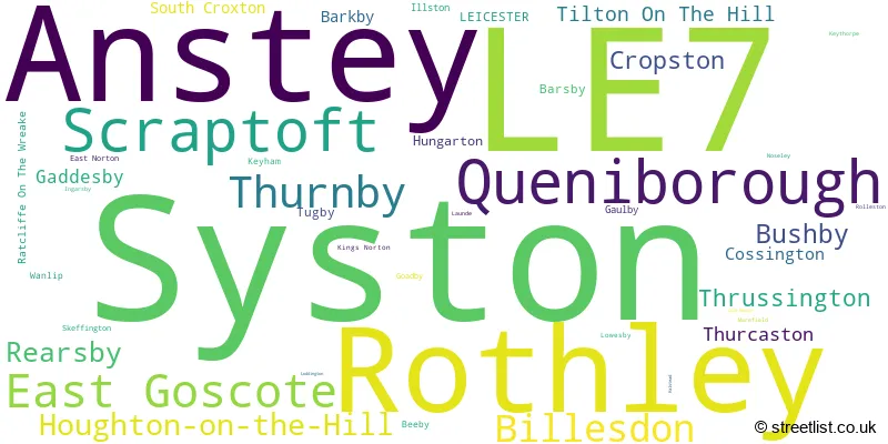
The largest settlement in the LE7 postal code is Syston followed by Anstey, and Rothley.
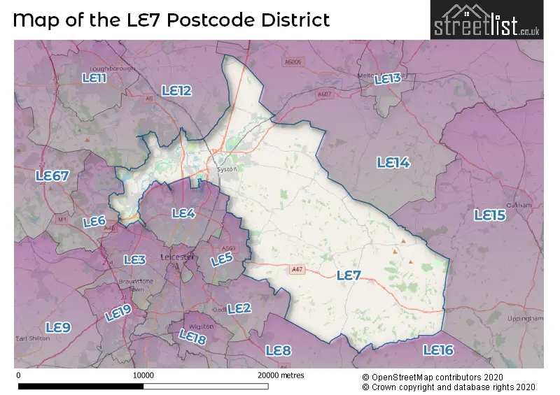
The LE7 Postcode shares a border with LE12 (Shepshed, Sileby, Mountsorrel), LE6 (Groby, Ratby, Newtown Linford), LE15 (OAKHAM, Uppingham, Barleythorpe), LE16 (MARKET HARBOROUGH, Great Bowden, Lubenham), LE2 (LEICESTER, Oadby, Glen Parva), LE3 (LEICESTER, Glenfield, Leicester Forest East), LE4 (LEICESTER, Birstall, Thurmaston), LE5 (LEICESTER, Hamilton, Evington), LE8 (Blaby, Countesthorpe, Whetstone) and LE14 (Asfordby, Old Dalby, Long Clawson).
In the LE7 postcode district, the primary settlement is Syston in the county of Leicestershire, which has the highest count. Other significant settlements in the district include Queniborough, Barkby, Beeby, East Goscote, South Croxton, Barsby, Cossington, Gaddesby, Ratcliffe On The Wreake, Rearsby, Thrussington, Wanlip, Anstey, Cropston, Rothley, Thurcaston, Billesdon, Bushby, Cold Newton, East Norton, Gaulby, Goadby, Houghton-on-the-Hill, Hungarton, Illston, Ingarsby, Keyham, Keythorpe, Kings Norton, Launde, Loddington, Lowesby, Marefield, Noseley, Rolleston, Scraptoft, Skeffington, Thurnby, Tilton On The Hill, and Tugby. The most significant post town in the district is Leicester.
For the district LE7, we have data on 6 postcode sectors. Here's a breakdown: The sector LE7 1, covers Syston in Leicestershire. The sector LE7 2, covers Syston in Leicestershire. The sector LE7 3, covers East Goscote and Queniborough in Leicestershire. The sector LE7 4, covers Rearsby and Thrussington and Gaddesby and Cossington in Leicestershire. The sector LE7 7, covers Anstey and Rothley in Leicestershire. The sector LE7 9, covers Scraptoft and Thurnby and Billesdon and Houghton-On-The-Hill in Leicestershire.

Map of the LE7 Postcode District
Explore the LE7 postcode district by using our free interactive map.
When it comes to local government, postal geography often disregards political borders. However, for a breakdown in the LE7 District: the district mostly encompasses the Charnwood District (B) (838 postcodes), followed by the Harborough District area (322 postcodes), followed by the Melton District (B) area (30 postcodes), followed by the Blaby District area (8 postcodes), and finally, the City of Leicester (B) area (7 postcodes).
Recent House Sales in LE7
| Date | Price | Address |
|---|---|---|
| 20/10/2023 | £185,000 | Church Hill, Scraptoft, Leicester, LE7 9TW |
| 10/10/2023 | £138,000 | Old Station Road, Syston, Leicester, LE7 1NT |
| 02/10/2023 | £320,000 | Beechwood Avenue, Queniborough, Leicester, LE7 3DU |
| 29/09/2023 | £289,000 | Wallace Healey Close, Queniborough, Leicester, LE7 2FQ |
| 29/09/2023 | £270,000 | Ashfield Drive, Anstey, Leicester, LE7 7TA |
| 27/09/2023 | £543,000 | Goadby, Leicester, LE7 9EE |
| 27/09/2023 | £302,500 | Wolfe End, Anstey, Leicester, LE7 7TR |
| 27/09/2023 | £275,000 | Bracken Dale, East Goscote, Leicester, LE7 3XS |
| 22/09/2023 | £558,000 | Glover Close, Anstey, Leicester, LE7 7LQ |
| 19/09/2023 | £260,000 | Mere Lane, Queniborough, Leicester, LE7 3DE |
Weather Forecast for LE7
Press Button to Show Forecast for Humberstone
| Time Period | Icon | Description | Temperature | Rain Probability | Wind |
|---|---|---|---|---|---|
| 12:00 to 15:00 | Overcast | 8.0°C (feels like 5.0°C) | 22.00% | ENE 11 mph | |
| 15:00 to 18:00 | Overcast | 8.0°C (feels like 5.0°C) | 16.00% | NE 11 mph | |
| 18:00 to 21:00 | Overcast | 7.0°C (feels like 4.0°C) | 15.00% | NE 11 mph | |
| 21:00 to 00:00 | Overcast | 6.0°C (feels like 3.0°C) | 12.00% | NE 11 mph |
Press Button to Show Forecast for Humberstone
| Time Period | Icon | Description | Temperature | Rain Probability | Wind |
|---|---|---|---|---|---|
| 00:00 to 03:00 | Overcast | 6.0°C (feels like 2.0°C) | 21.00% | NNE 11 mph | |
| 03:00 to 06:00 | Light rain | 6.0°C (feels like 2.0°C) | 58.00% | N 13 mph | |
| 06:00 to 09:00 | Heavy rain | 6.0°C (feels like 2.0°C) | 87.00% | N 13 mph | |
| 09:00 to 12:00 | Heavy rain | 7.0°C (feels like 3.0°C) | 81.00% | NNW 11 mph | |
| 12:00 to 15:00 | Light rain | 8.0°C (feels like 5.0°C) | 58.00% | NW 11 mph | |
| 15:00 to 18:00 | Light rain | 10.0°C (feels like 8.0°C) | 49.00% | WNW 9 mph | |
| 18:00 to 21:00 | Partly cloudy (day) | 10.0°C (feels like 8.0°C) | 7.00% | W 9 mph | |
| 21:00 to 00:00 | Partly cloudy (night) | 7.0°C (feels like 5.0°C) | 3.00% | SW 7 mph |
Press Button to Show Forecast for Humberstone
| Time Period | Icon | Description | Temperature | Rain Probability | Wind |
|---|---|---|---|---|---|
| 00:00 to 03:00 | Partly cloudy (night) | 6.0°C (feels like 3.0°C) | 1.00% | SSW 7 mph | |
| 03:00 to 06:00 | Clear night | 4.0°C (feels like 2.0°C) | 1.00% | SSW 7 mph | |
| 06:00 to 09:00 | Sunny day | 5.0°C (feels like 2.0°C) | 1.00% | S 7 mph | |
| 09:00 to 12:00 | Sunny day | 11.0°C (feels like 8.0°C) | 1.00% | S 11 mph | |
| 12:00 to 15:00 | Cloudy | 13.0°C (feels like 10.0°C) | 6.00% | S 13 mph | |
| 15:00 to 18:00 | Cloudy | 14.0°C (feels like 11.0°C) | 6.00% | S 13 mph | |
| 18:00 to 21:00 | Sunny day | 13.0°C (feels like 11.0°C) | 2.00% | S 11 mph | |
| 21:00 to 00:00 | Clear night | 9.0°C (feels like 7.0°C) | 2.00% | SSE 9 mph |
Press Button to Show Forecast for Humberstone
| Time Period | Icon | Description | Temperature | Rain Probability | Wind |
|---|---|---|---|---|---|
| 00:00 to 03:00 | Clear night | 8.0°C (feels like 5.0°C) | 3.00% | SE 9 mph | |
| 03:00 to 06:00 | Clear night | 7.0°C (feels like 4.0°C) | 3.00% | SE 9 mph | |
| 06:00 to 09:00 | Sunny day | 8.0°C (feels like 5.0°C) | 4.00% | ESE 9 mph | |
| 09:00 to 12:00 | Cloudy | 12.0°C (feels like 10.0°C) | 7.00% | ESE 11 mph | |
| 12:00 to 15:00 | Partly cloudy (day) | 15.0°C (feels like 13.0°C) | 7.00% | SE 11 mph | |
| 15:00 to 18:00 | Partly cloudy (day) | 16.0°C (feels like 13.0°C) | 9.00% | SE 11 mph | |
| 18:00 to 21:00 | Cloudy | 14.0°C (feels like 13.0°C) | 9.00% | ESE 9 mph | |
| 21:00 to 00:00 | Cloudy | 11.0°C (feels like 10.0°C) | 10.00% | ESE 9 mph |
Where is the LE7 Postcode District?
The postcode district for LE7 is located in Leicester. It is surrounded by nearby towns such as Wigston to the South West, Melton Mowbray to the North East, Oakham to the East, Loughborough to the North West, Markfield to the West, Market Harborough to the South, and Corby to the South East. Additionally, Leicester is approximately 87.6 miles away from the centre of London.
The district is within the post town of LEICESTER.
The sector has postcodes within the nation of England.
The LE7 Postcode District is covers the following regions.
- Leicestershire CC and Rutland - Leicestershire, Rutland and Northamptonshire - East Midlands (England)
- Leicester - Leicestershire, Rutland and Northamptonshire - East Midlands (England)
| Postcode Sector | Delivery Office |
|---|---|
| LE7 1 | Syston Scale Payment Delivery Office |
| LE7 2 | Syston Scale Payment Delivery Office |
| LE7 3 | Syston Scale Payment Delivery Office |
| LE7 4 | Syston Scale Payment Delivery Office |
| LE7 7 | Anstey Scale Payment Delivery Office |
| LE7 7 | Rothley Scale Payment Delivery Office |
| LE7 9 | Leicester East Delivery Office |
| LE7 9 | Billesdelivery Officen Scale Payment Delivery Office |
| LE7 9 | Tilton On The Hill Scale Payment Delivery Office |
| L | E | 7 | - | X | X | X |
| L | E | 7 | Space | Numeric | Letter | Letter |
Current Monthly Rental Prices
| # Bedrooms | Min Price | Max Price | Avg Price |
|---|---|---|---|
| £692 | £692 | £692 | |
| 1 | £595 | £1,000 | £798 |
| 2 | £795 | £1,600 | £1,101 |
| 3 | £895 | £1,750 | £1,141 |
| 4 | £1,100 | £2,000 | £1,485 |
| 5 | £1,900 | £3,500 | £2,883 |
Current House Prices
| # Bedrooms | Min Price | Max Price | Avg Price |
|---|---|---|---|
| £45,000 | £850,000 | £423,750 | |
| 1 | £70,000 | £220,000 | £135,958 |
| 2 | £103,000 | £899,000 | £255,072 |
| 3 | £123,750 | £850,000 | £341,588 |
| 4 | £270,000 | £1,250,000 | £498,305 |
| 5 | £325,000 | £2,500,000 | £710,993 |
| 6 | £645,000 | £2,500,000 | £1,391,429 |
| 8 | £55,300 | £2,250,000 | £925,075 |
| 10 | £2,750,000 | £2,750,000 | £2,750,000 |
Estate Agents who Operate in the LE7 District
| Logo | Name | Brand Name | Address | Contact Number | Total Properties |
|---|---|---|---|---|---|
 | Syston | Newton Fallowell | 1250 Melton Road, Syston, Leicester, LE7 2HD | 0116 344 0110 | 57 |
 | Anstey | Judge Estate Agents | 13 The Nook, Anstey LE7 7AZ | 0116 216 4833 | 33 |
 | Syston | Aston & Co | 4 High Street, Syston, Leicester LE7 1GP | 0116 216 3019 | 31 |
 | Melton Mowbray | Bentons | 47 Nottingham Street Melton Mowbray Leicestershire, LE13 1NN | 01664 494408 | 30 |
 | Syston | Spencers Estate Agency | 1239 Melton Road, Syston, Leicester, Leicestershire, LE7 2JT | 0116 216 2260 | 27 |
- Anstey
- Barkby
- Barkby Thorpe
- Barsby
- Beeby
- Billesdon
- Brooksby
- Cold Newton
- Cossington
- Cropston
- East Goscote
- East Norton
- Gaddesby
- Gaulby
- Goadby
- Houghton on the Hill
- Hungarton
- Illston on the Hill
- John O'Gaunt
- Keyham
- Keythorpe
- King's Norton
- Leicester
- Little Stretton
- Loddington
- Noseley
- Owston
- Queniborough
- Ratcliffe on the Wreake
- Rearsby
- Rolleston
- Rothley
- Seagrave
- Six Hills
- Skeffington
- South Croxton
- Syston
- Three Gates
- Thrussington
- Thurcaston
- Thurmaston
- Tilton on the Hill
- Tugby
- Twyford
- Wanlip
| Type of Property | 2018 Average | 2018 Sales | 2017 Average | 2017 Sales | 2016 Average | 2016 Sales | 2015 Average | 2015 Sales |
|---|---|---|---|---|---|---|---|---|
| Detached | £361,828 | 487 | £361,031 | 476 | £332,023 | 533 | £335,691 | 464 |
| Semi-Detached | £216,300 | 334 | £215,756 | 291 | £205,381 | 277 | £191,287 | 265 |
| Terraced | £185,548 | 190 | £185,935 | 183 | £168,984 | 198 | £159,446 | 186 |
| Flats | £131,092 | 63 | £122,866 | 60 | £120,870 | 58 | £126,902 | 44 |