The LE7 3 postcode sector is within the county of Leicestershire.
Did you know? According to the 2021 Census, the LE7 3 postcode sector is home to a bustling 5,851 residents!
Given that each sector allows for 400 unique postcode combinations. Letters C, I, K, M, O and V are not allowed in the last two letters of a postcode. With 156 postcodes already in use, this leaves 244 units available.
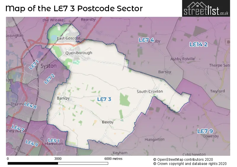
The largest settlement in the LE7 3 postal code is Queniborough followed by East Goscote, and Barkby.
The LE7 3 Postcode shares a border with LE4 8 (Thurmaston), LE5 1 (Hamilton, LEICESTER, Humberstone), LE7 4 (Rearsby, Thrussington, Cossington), LE7 9 (Scraptoft, Thurnby, Houghton-on-the-Hill), LE4 9 (LEICESTER), LE7 1 (Syston) and LE7 2 (Syston, Queniborough).
The sector is within the post town of LEICESTER.
LE7 3 is a postcode sector within the LE7 postcode district which is within the LE Leicester postcode area.
The Royal Mail delivery office for the LE7 3 postal sector is the Syston Scale Payment Delivery Office.
The area of the LE7 3 postcode sector is 13.11 square miles which is 33.96 square kilometres or 8,391.67 square acres.
Waterways within the LE7 3 postcode sector include the River Wreake, Syston Brook, Barkby Brook.

Map of the LE7 3 Postcode Sector
Explore the LE7 3 postcode sector by using our free interactive map.
| L | E | 7 | - | 3 | X | X |
| L | E | 7 | Space | 3 | Letter | Letter |
Official List of Streets
East Goscote (55 Streets)
Queniborough (50 Streets)
Barkby (13 Streets)
Beeby (5 Streets)
Unofficial Streets or Alternative Spellings
Scraptoft
BEEBY ROAD HAMILTON LANEQueniborough
PORRITT WAYLEICESTER
BARKBYTHORPE ROAD LILAC WAYHamilton
HACKNESS ROAD LAVERTON ROADSyston
BARKBY LANE DROVERS ROAD RIDGEMERE CLOSEThurmaston
BARKBY THORPE LANEBarsby
SOUTH CROXTON ROADRearsby
NURSERYMAN WAY POLYANTHA SQUARE TEA ROSE CRESCENT WILLOWBROOK WAYWeather Forecast for LE7 3
Press Button to Show Forecast for Syston
| Time Period | Icon | Description | Temperature | Rain Probability | Wind |
|---|---|---|---|---|---|
| 09:00 to 12:00 | Overcast | 8.0°C (feels like 5.0°C) | 53.00% | ENE 11 mph | |
| 12:00 to 15:00 | Light rain | 8.0°C (feels like 5.0°C) | 50.00% | ENE 11 mph | |
| 15:00 to 18:00 | Overcast | 8.0°C (feels like 5.0°C) | 16.00% | NE 11 mph | |
| 18:00 to 21:00 | Overcast | 8.0°C (feels like 5.0°C) | 14.00% | NE 11 mph | |
| 21:00 to 00:00 | Overcast | 6.0°C (feels like 3.0°C) | 10.00% | NE 11 mph |
Press Button to Show Forecast for Syston
| Time Period | Icon | Description | Temperature | Rain Probability | Wind |
|---|---|---|---|---|---|
| 00:00 to 03:00 | Overcast | 6.0°C (feels like 2.0°C) | 18.00% | NNE 11 mph | |
| 03:00 to 06:00 | Light rain | 6.0°C (feels like 2.0°C) | 55.00% | N 13 mph | |
| 06:00 to 09:00 | Heavy rain | 6.0°C (feels like 2.0°C) | 86.00% | N 13 mph | |
| 09:00 to 12:00 | Heavy rain | 7.0°C (feels like 3.0°C) | 82.00% | NNW 11 mph | |
| 12:00 to 15:00 | Light rain | 8.0°C (feels like 6.0°C) | 56.00% | NW 11 mph | |
| 15:00 to 18:00 | Light rain | 10.0°C (feels like 8.0°C) | 50.00% | WNW 9 mph | |
| 18:00 to 21:00 | Partly cloudy (day) | 10.0°C (feels like 8.0°C) | 8.00% | W 9 mph | |
| 21:00 to 00:00 | Partly cloudy (night) | 6.0°C (feels like 4.0°C) | 5.00% | SW 7 mph |
Press Button to Show Forecast for Syston
| Time Period | Icon | Description | Temperature | Rain Probability | Wind |
|---|---|---|---|---|---|
| 00:00 to 03:00 | Partly cloudy (night) | 6.0°C (feels like 3.0°C) | 2.00% | SSW 7 mph | |
| 03:00 to 06:00 | Clear night | 4.0°C (feels like 2.0°C) | 1.00% | SSW 7 mph | |
| 06:00 to 09:00 | Sunny day | 5.0°C (feels like 3.0°C) | 1.00% | S 7 mph | |
| 09:00 to 12:00 | Sunny day | 11.0°C (feels like 8.0°C) | 1.00% | S 11 mph | |
| 12:00 to 15:00 | Overcast | 13.0°C (feels like 10.0°C) | 9.00% | S 13 mph | |
| 15:00 to 18:00 | Cloudy | 14.0°C (feels like 11.0°C) | 6.00% | S 13 mph | |
| 18:00 to 21:00 | Sunny day | 13.0°C (feels like 11.0°C) | 2.00% | S 11 mph | |
| 21:00 to 00:00 | Clear night | 9.0°C (feels like 7.0°C) | 2.00% | SSE 9 mph |
Press Button to Show Forecast for Syston
| Time Period | Icon | Description | Temperature | Rain Probability | Wind |
|---|---|---|---|---|---|
| 00:00 to 03:00 | Clear night | 8.0°C (feels like 5.0°C) | 3.00% | SE 9 mph | |
| 03:00 to 06:00 | Clear night | 7.0°C (feels like 4.0°C) | 3.00% | SE 9 mph | |
| 06:00 to 09:00 | Sunny day | 8.0°C (feels like 6.0°C) | 4.00% | ESE 9 mph | |
| 09:00 to 12:00 | Partly cloudy (day) | 12.0°C (feels like 10.0°C) | 4.00% | ESE 11 mph | |
| 12:00 to 15:00 | Partly cloudy (day) | 15.0°C (feels like 13.0°C) | 6.00% | SE 11 mph | |
| 15:00 to 18:00 | Cloudy | 16.0°C (feels like 14.0°C) | 10.00% | ESE 11 mph | |
| 18:00 to 21:00 | Cloudy | 14.0°C (feels like 13.0°C) | 9.00% | ESE 9 mph | |
| 21:00 to 00:00 | Cloudy | 11.0°C (feels like 10.0°C) | 10.00% | E 9 mph |
Schools and Places of Education Within the LE7 3 Postcode Sector
Broomfield Community Primary School
Academy converter
Ploughmans Lea, Leicester, Leicestershire, LE7 3ZQ
Head: Miss Alex Allison
Ofsted Rating: Good
Inspection: 2021-06-23 (1039 days ago)
Website: Visit Broomfield Community Primary School Website
Phone: 01162606704
Number of Pupils: 184
Queniborough Church of England Primary School
Academy converter
Coppice Lane, Leicester, Leicestershire, LE7 3DR
Head: Mrs Hannah Roddy
Ofsted Rating: Good
Inspection: 2018-10-02 (2034 days ago)
Website: Visit Queniborough Church of England Primary School Website
Phone: 01162606700
Number of Pupils: 204
The Pochin School
Academy converter
School Lane, Leicester, Leicestershire, LE7 3QL
Head: Mrs Heather Sharpe
Ofsted Rating: Outstanding
Inspection: 2014-04-30 (3650 days ago)
Website: Visit The Pochin School Website
Phone: 01162692078
Number of Pupils: 133
House Prices in the LE7 3 Postcode Sector
| Type of Property | 2018 Average | 2018 Sales | 2017 Average | 2017 Sales | 2016 Average | 2016 Sales | 2015 Average | 2015 Sales |
|---|---|---|---|---|---|---|---|---|
| Detached | £343,272 | 67 | £361,376 | 68 | £254,242 | 45 | £274,982 | 28 |
| Semi-Detached | £196,128 | 34 | £223,681 | 46 | £184,075 | 38 | £180,107 | 41 |
| Terraced | £192,622 | 30 | £165,454 | 22 | £171,385 | 13 | £166,915 | 13 |
| Flats | £0 | 0 | £0 | 0 | £0 | 0 | £0 | 0 |
Important Postcodes LE7 3 in the Postcode Sector
LE7 3DR is the postcode for Queniborough CE Primary School, Coppice Lane, Queniborough CE Primary School, Coppice Lane, Queniborough, and BLOCK A, Queniborough CE Primary School, Coppice Lane
LE7 3QL is the postcode for The Pochin School, 5 School Lane, Barkby
LE7 3ZL is the postcode for East Goscote Parish Council, The Village Hall, Long Furrow, East Goscote
LE7 3ZQ is the postcode for Broomfield Cp School, Ploughmans Lea, East Goscote, BLOCKS A, B, C, Broomfield Cp School, Ploughmans Lea, and Broomfield Cp School, Ploughmans Lea
| The LE7 3 Sector is within these Local Authorities |
|
|---|---|
| The LE7 3 Sector is within these Counties |
|
| The LE7 3 Sector is within these Water Company Areas |
|