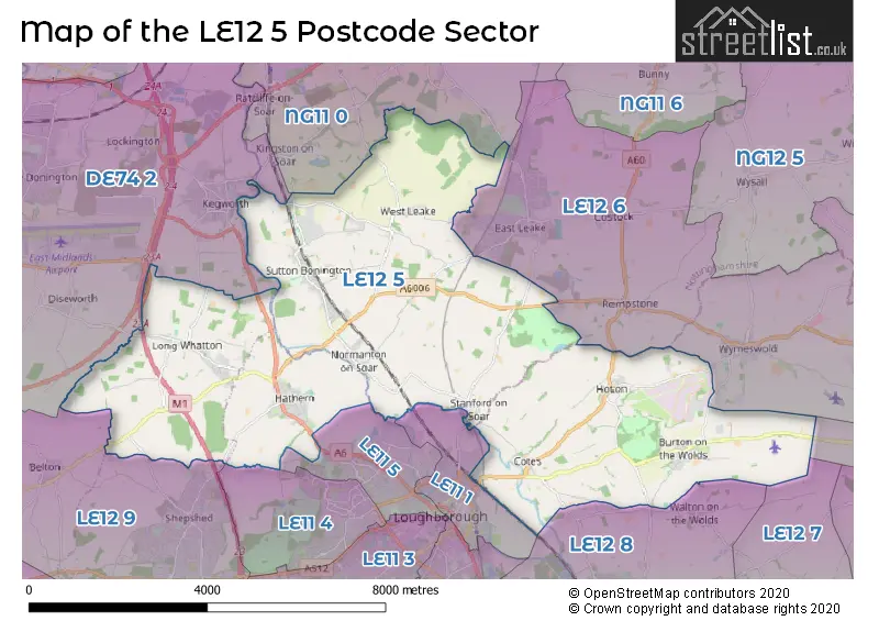
The LE12 5 postcode sector stands on the Leicestershire and Nottinghamshire border.
Did you know? According to the 2021 Census, the LE12 5 postcode sector is home to a bustling 8,139 residents!
Given that each sector allows for 400 unique postcode combinations. Letters C, I, K, M, O and V are not allowed in the last two letters of a postcode. With 201 postcodes already in use, this leaves 199 units available.
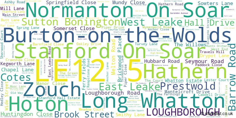
The largest settlement in the LE12 5 postal code is Hathern followed by Sutton Bonington, and Burton-on-the-Wolds.
The LE12 5 Postcode shares a border with NG11 0 (Gotham, Ratcliffe-on-Soar, Barton-in-Fabis), LE12 6 (East Leake, Wymeswold, Costock), LE12 7 (Sileby, Mountsorrel, Seagrave), LE12 8 (Barrow Upon Soar, Quorn, Woodhouse Eaves), LE12 9 (Shepshed, Belton, Osgathorpe), LE14 3 (Asfordby, Old Dalby, Asfordby Hill), DE74 2 (Castle Donington, Kegworth, Diseworth), LE11 1 (LOUGHBOROUGH), LE11 4 (LOUGHBOROUGH) and LE11 5 (LOUGHBOROUGH).
The sector is within the post town of LOUGHBOROUGH.
LE12 5 is a postcode sector within the LE12 postcode district which is within the LE Leicester postcode area.
The Royal Mail delivery office for the LE12 5 postal sector is the Sutton Bonington Scale Payment Delivery Office and Normanton On Soar Scale Payment Delivery Office and Loughborough Delivery Office.
The area of the LE12 5 postcode sector is 26.14 square miles which is 67.71 square kilometres or 16,732.60 square acres.
The LE12 5 postcode sector is crossed by the A42 Major A road.
The LE12 5 postcode sector is crossed by the M1 motorway.
Waterways within the LE12 5 postcode sector include the River Soar, Loughborough Navigation (River Soar).

Map of the LE12 5 Postcode Sector
Explore the LE12 5 postcode sector by using our free interactive map.
| L | E | 1 | 2 | - | 5 | X | X |
| L | E | 1 | 2 | Space | 5 | Letter | Letter |
Official List of Streets
Hathern (46 Streets)
Long Whatton (26 Streets)
Cotes (5 Streets)
LOUGHBOROUGH (4 Streets)
Sutton Bonington (28 Streets)
Burton-on-the-Wolds (27 Streets)
West Leake (4 Streets)
Hoton (8 Streets)
Normanton On Soar (10 Streets)
Stanford On Soar (8 Streets)
Prestwold (2 Streets)
Zouch (1 Streets)
East Leake (1 Streets)
Unofficial Streets or Alternative Spellings
Wymeswold
BURTON LANE ALLSOPPS LANE DARK LANE DORMER COURT DRY POT LANE GREEN HILL RISE HATHERN DRIVE KINGS BRIDGE LOWER HOLME OAKLEY ROAD PITHOUSE LANE SAINT PETERS AVENUE STANFORD ROAD STATION TERRACE STONEBOW WALK SWAN COURT THE SIDINGS TOWN END COURT UPPER HOLME VILLAGE FARM VILLAGE ROAD VINE TREE TERRACE WESTMEADOW LANE WILLIAM RAILTON ROAD WOODS MEWS WOSSOCK LANE ZOUCH ROADBarrow Upon Soar
BANDALLS LANE COTES ROAD NOTTINGHAM ROADCostock
LOUGHBOROUGH ROADEast Leake
ELIZABETH DRIVE GOTHAM ROAD LOUGHBOROUGH ROAD REMPSTONE ROAD WEST LEAKE ROAD WOODGATE ROADRempstone
ASHBY ROADLOUGHBOROUGH
DERBY ROAD MEADOW LANEShepshed
HALLAMFORD ROAD HATHERN ROADBelton
REMPSTONE ROADKingston-on-Soar
WEST LEAKE LANEKegworth
KINGSTON LANE LONDON ROAD STATION ROAD WHATTON ROADGotham
LEAKE ROADWeather Forecast for LE12 5
Press Button to Show Forecast for Sutton Bonington
| Time Period | Icon | Description | Temperature | Rain Probability | Wind |
|---|---|---|---|---|---|
| 06:00 to 09:00 | Cloudy | 4.0°C (feels like 2.0°C) | 8.00% | NE 4 mph | |
| 09:00 to 12:00 | Cloudy | 8.0°C (feels like 5.0°C) | 14.00% | ENE 9 mph | |
| 12:00 to 15:00 | Light rain | 8.0°C (feels like 6.0°C) | 53.00% | E 9 mph | |
| 15:00 to 18:00 | Overcast | 8.0°C (feels like 6.0°C) | 17.00% | ENE 11 mph | |
| 18:00 to 21:00 | Overcast | 8.0°C (feels like 5.0°C) | 14.00% | NE 9 mph | |
| 21:00 to 00:00 | Overcast | 7.0°C (feels like 4.0°C) | 12.00% | NE 9 mph |
Press Button to Show Forecast for Sutton Bonington
| Time Period | Icon | Description | Temperature | Rain Probability | Wind |
|---|---|---|---|---|---|
| 00:00 to 03:00 | Overcast | 6.0°C (feels like 3.0°C) | 17.00% | NNE 7 mph | |
| 03:00 to 06:00 | Light rain | 6.0°C (feels like 2.0°C) | 55.00% | N 9 mph | |
| 06:00 to 09:00 | Heavy rain | 6.0°C (feels like 2.0°C) | 78.00% | N 9 mph | |
| 09:00 to 12:00 | Heavy rain | 7.0°C (feels like 4.0°C) | 78.00% | NNW 9 mph | |
| 12:00 to 15:00 | Heavy rain | 8.0°C (feels like 6.0°C) | 73.00% | NW 9 mph | |
| 15:00 to 18:00 | Light rain shower (day) | 10.0°C (feels like 8.0°C) | 37.00% | WNW 9 mph | |
| 18:00 to 21:00 | Partly cloudy (day) | 10.0°C (feels like 8.0°C) | 8.00% | W 7 mph | |
| 21:00 to 00:00 | Partly cloudy (night) | 7.0°C (feels like 5.0°C) | 4.00% | SW 7 mph |
Press Button to Show Forecast for Sutton Bonington
| Time Period | Icon | Description | Temperature | Rain Probability | Wind |
|---|---|---|---|---|---|
| 00:00 to 03:00 | Clear night | 6.0°C (feels like 4.0°C) | 1.00% | SSW 4 mph | |
| 03:00 to 06:00 | Clear night | 4.0°C (feels like 2.0°C) | 0.00% | SSW 4 mph | |
| 06:00 to 09:00 | Sunny day | 5.0°C (feels like 2.0°C) | 2.00% | S 4 mph | |
| 09:00 to 12:00 | Sunny day | 11.0°C (feels like 8.0°C) | 1.00% | S 9 mph | |
| 12:00 to 15:00 | Cloudy | 13.0°C (feels like 10.0°C) | 6.00% | S 11 mph | |
| 15:00 to 18:00 | Cloudy | 14.0°C (feels like 11.0°C) | 6.00% | S 11 mph | |
| 18:00 to 21:00 | Sunny day | 13.0°C (feels like 11.0°C) | 3.00% | S 9 mph | |
| 21:00 to 00:00 | Clear night | 9.0°C (feels like 7.0°C) | 2.00% | SSE 7 mph |
Press Button to Show Forecast for Sutton Bonington
| Time Period | Icon | Description | Temperature | Rain Probability | Wind |
|---|---|---|---|---|---|
| 00:00 to 03:00 | Clear night | 8.0°C (feels like 6.0°C) | 2.00% | SSE 7 mph | |
| 03:00 to 06:00 | Clear night | 7.0°C (feels like 4.0°C) | 2.00% | SE 7 mph | |
| 06:00 to 09:00 | Sunny day | 8.0°C (feels like 5.0°C) | 4.00% | ESE 7 mph | |
| 09:00 to 12:00 | Sunny day | 13.0°C (feels like 11.0°C) | 5.00% | ESE 9 mph | |
| 12:00 to 15:00 | Cloudy | 15.0°C (feels like 13.0°C) | 10.00% | SE 11 mph | |
| 15:00 to 18:00 | Partly cloudy (day) | 16.0°C (feels like 14.0°C) | 9.00% | SE 9 mph | |
| 18:00 to 21:00 | Cloudy | 15.0°C (feels like 13.0°C) | 10.00% | ESE 7 mph | |
| 21:00 to 00:00 | Cloudy | 12.0°C (feels like 10.0°C) | 9.00% | E 7 mph |
Schools and Places of Education Within the LE12 5 Postcode Sector
Burton-on-the-Wolds Primary School
Community school
Barrow Road, Loughborough, Leicestershire, LE12 5TB
Head: Mrs Claire Wilson
Ofsted Rating: Outstanding
Inspection: 2018-11-15 (1990 days ago)
Website: Visit Burton-on-the-Wolds Primary School Website
Phone: 01509880298
Number of Pupils: 191
Hathern Church of England Primary School
Voluntary controlled school
Pasture Lane, Loughborough, Leicestershire, LE12 5LJ
Head: Mr Stuart Bailey
Ofsted Rating: Good
Inspection: 2022-03-30 (759 days ago)
Website: Visit Hathern Church of England Primary School Website
Phone: 01509842569
Number of Pupils: 190
Long Whatton Church of England Primary School and Community Centre
Voluntary controlled school
The Green, Loughborough, Leicestershire, LE12 5DB
Head: Mrs Sara Gray
Ofsted Rating: Good
Inspection: 2019-10-24 (1647 days ago)
Website: Visit Long Whatton Church of England Primary School and Community Centre Website
Phone: 01509842239
Number of Pupils: 95
Normanton-on-Soar Primary School
Community school
Main Street, Loughborough, Leicestershire, LE12 5HB
Head: Mrs Sarah Philpott
Ofsted Rating: Requires improvement
Inspection: 2022-12-14 (500 days ago)
Website: Visit Normanton-on-Soar Primary School Website
Phone: 01509842326
Number of Pupils: 48
Sutton Bonington Primary School
Community school
Park Lane, Loughborough, Leicestershire, LE12 5NH
Head: Mr Paul Allen
Ofsted Rating: Good
Inspection: 2019-05-21 (1803 days ago)
Website: Visit Sutton Bonington Primary School Website
Phone: 01509672661
Number of Pupils: 154
House Prices in the LE12 5 Postcode Sector
| Type of Property | 2018 Average | 2018 Sales | 2017 Average | 2017 Sales | 2016 Average | 2016 Sales | 2015 Average | 2015 Sales |
|---|---|---|---|---|---|---|---|---|
| Detached | £394,735 | 79 | £362,909 | 82 | £305,306 | 68 | £325,571 | 60 |
| Semi-Detached | £229,403 | 37 | £200,239 | 43 | £206,953 | 45 | £196,044 | 33 |
| Terraced | £249,904 | 27 | £182,437 | 25 | £179,278 | 29 | £190,234 | 31 |
| Flats | £165,300 | 5 | £153,400 | 5 | £188,333 | 3 | £143,000 | 4 |
Important Postcodes LE12 5 in the Postcode Sector
LE12 5HB is the postcode for Normanton on Soar Primary School, Main Street
LE12 5LB is the postcode for The Surgery, 5 Cross Street
LE12 5NH is the postcode for Sutton Bonington Primary School, Park Lane
LE12 5RB is the postcode for Animal and Plant Health Agency, The Elms, College Road
LE12 5RD is the postcode for SB SPORTS CENTRE, University of Nottingham, College Road, FOOD SCIENCES, University of Nottingham, College Road, SOUTH LABORATORY, University of Nottingham, College Road, BIO ENERGY BUILDING UNIVERSITY OF NOTTINGHAM, University of Nottingham, College Road, NORMANTON HOUSE, University of Nottingham, College Road, VETERINARY SCHOOL, University of Nottingham, College Road, REMPSTONE HALL, University of Nottingham, College Road, GATEWAY BUILDING (BIO SCIENCES), University of Nottingham, College Road, WYMESWOLD HOUSE, University of Nottingham, College Road, SB MAIN BUILDING & LIBRARY, University of Nottingham, College Road, BIO ENERGY & BREWING SCIENCE BUILDING, University of Nottingham, College Road, THE FIRS (KEITH CAMPBELL BUILDING), University of Nottingham, College Road, NORTH LABORATORY, University of Nottingham, College Road, THE BARN, University of Nottingham, College Road, BIO ENERGY & BREWING SCIENCE BUILDING, University of Nottingham, College Road, and PLANT SCIENCES, University of Nottingham, College Road
LE12 5TB is the postcode for Burton-on-the-Wolds Cp School, Barrow Road
| The LE12 5 Sector is within these Local Authorities |
|
|---|---|
| The LE12 5 Sector is within these Counties |
|
| The LE12 5 Sector is within these Water Company Areas |
|