The LE12 9 postcode sector is within the county of Leicestershire.
Did you know? According to the 2021 Census, the LE12 9 postcode sector is home to a bustling 16,136 residents!
Given that each sector allows for 400 unique postcode combinations. Letters C, I, K, M, O and V are not allowed in the last two letters of a postcode. With 332 postcodes already in use, this leaves 68 units available.
The largest settlement in the LE12 9 postal code is Shepshed followed by Belton, and Osgathorpe.
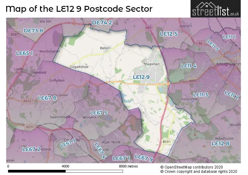
The LE12 9 Postcode shares a border with LE11 3 (LOUGHBOROUGH, Nanpantan), LE12 5 (Hathern, Sutton Bonington, Burton-on-the-Wolds), LE12 8 (Barrow Upon Soar, Quorn, Woodhouse Eaves), LE67 8 (Thringstone, Coleorton, Swannington), DE73 8 (Melbourne, Breedon-on-the-Hill), DE74 2 (Castle Donington, Kegworth, Diseworth), LE11 4 (LOUGHBOROUGH), LE65 1 (ASHBY-DE-LA-ZOUCH, Packington, Worthington), LE67 4 (COALVILLE), LE67 5 (Whitwick) and LE67 9 (MARKFIELD, Stanton Under Bardon, Ulverscroft).
The sector is within the post town of LOUGHBOROUGH.
LE12 9 is a postcode sector within the LE12 postcode district which is within the LE Leicester postcode area.
The Royal Mail delivery office for the LE12 9 postal sector is the Loughborough Delivery Office and Shepshed Delivery Office and Belton (le) Scale Payment Delivery Office.
The area of the LE12 9 postcode sector is 14.30 square miles which is 37.03 square kilometres or 9,150.10 square acres.
The LE12 9 postcode sector is crossed by the M1 motorway.
The LE12 9 postcode sector is crossed by the A42 Major A road.

Map of the LE12 9 Postcode Sector
Explore the LE12 9 postcode sector by using our free interactive map.
| L | E | 1 | 2 | - | 9 | X | X |
| L | E | 1 | 2 | Space | 9 | Letter | Letter |
Official List of Streets
Shepshed (223 Streets)
Osgathorpe (16 Streets)
Belton (20 Streets)
Charley (3 Streets)
Unofficial Streets or Alternative Spellings
Woodhouse Eaves
BEACON ROAD SHEPSHED ROADLOUGHBOROUGH
ASHBY ROAD ASHBY ROAD CENTRAL BROMLEY LANE CHEAPSIDE CHURCH VIEW DUCANE CLOSE EMMERSONS COURT ENNION COURT FAWCETT CLOSE GELSCOE LANE GRACE DIEU LANE HIGHFIELD CLOSE HILLSIDE WAY JUBILEE PATH KINGS STREET LACEY COURT MARJORAM CLOSE MC CARTHY ROAD NEW WALK OAKLEY AVENUE POPPY COURT SAINT BOTOLPH ROAD SAINT JAMES CLOSE SAINT JAMES ROAD SAINT WINEFRIDE ROAD SALMON MEWS SANDHOLE LANE SHEPSHED ROAD SNARROWS ROAD ST. MARYS CLOSE STOCKING LANE THE TOFT TUNNICLIFFE COURT TYLER BRIDGECOALVILLE
ABBEY ROADThringstone
ASHBY ROADGriffydam
LOWER BRANDWeather Forecast for LE12 9
Press Button to Show Forecast for Shepshed
| Time Period | Icon | Description | Temperature | Rain Probability | Wind |
|---|---|---|---|---|---|
| 06:00 to 09:00 | Cloudy | 5.0°C (feels like 2.0°C) | 9.00% | NE 7 mph | |
| 09:00 to 12:00 | Overcast | 7.0°C (feels like 5.0°C) | 16.00% | ENE 11 mph | |
| 12:00 to 15:00 | Light rain | 8.0°C (feels like 5.0°C) | 55.00% | ENE 9 mph | |
| 15:00 to 18:00 | Overcast | 8.0°C (feels like 5.0°C) | 16.00% | ENE 11 mph | |
| 18:00 to 21:00 | Overcast | 8.0°C (feels like 5.0°C) | 13.00% | NE 11 mph | |
| 21:00 to 00:00 | Overcast | 6.0°C (feels like 3.0°C) | 11.00% | NE 11 mph |
Press Button to Show Forecast for Shepshed
| Time Period | Icon | Description | Temperature | Rain Probability | Wind |
|---|---|---|---|---|---|
| 00:00 to 03:00 | Overcast | 6.0°C (feels like 2.0°C) | 17.00% | NNE 11 mph | |
| 03:00 to 06:00 | Light rain | 6.0°C (feels like 2.0°C) | 55.00% | NNE 11 mph | |
| 06:00 to 09:00 | Heavy rain | 6.0°C (feels like 2.0°C) | 78.00% | N 11 mph | |
| 09:00 to 12:00 | Heavy rain | 7.0°C (feels like 3.0°C) | 78.00% | NNW 11 mph | |
| 12:00 to 15:00 | Heavy rain | 8.0°C (feels like 6.0°C) | 75.00% | NW 11 mph | |
| 15:00 to 18:00 | Light rain shower (day) | 10.0°C (feels like 8.0°C) | 37.00% | WNW 9 mph | |
| 18:00 to 21:00 | Partly cloudy (day) | 10.0°C (feels like 8.0°C) | 8.00% | W 9 mph | |
| 21:00 to 00:00 | Clear night | 7.0°C (feels like 5.0°C) | 4.00% | SW 7 mph |
Press Button to Show Forecast for Shepshed
| Time Period | Icon | Description | Temperature | Rain Probability | Wind |
|---|---|---|---|---|---|
| 00:00 to 03:00 | Clear night | 5.0°C (feels like 3.0°C) | 1.00% | SSW 7 mph | |
| 03:00 to 06:00 | Clear night | 4.0°C (feels like 1.0°C) | 0.00% | SSW 7 mph | |
| 06:00 to 09:00 | Sunny day | 5.0°C (feels like 3.0°C) | 2.00% | S 7 mph | |
| 09:00 to 12:00 | Sunny day | 11.0°C (feels like 8.0°C) | 1.00% | S 11 mph | |
| 12:00 to 15:00 | Overcast | 13.0°C (feels like 10.0°C) | 9.00% | S 13 mph | |
| 15:00 to 18:00 | Partly cloudy (day) | 14.0°C (feels like 11.0°C) | 4.00% | S 13 mph | |
| 18:00 to 21:00 | Sunny day | 13.0°C (feels like 11.0°C) | 3.00% | S 11 mph | |
| 21:00 to 00:00 | Clear night | 9.0°C (feels like 7.0°C) | 2.00% | SSE 9 mph |
Press Button to Show Forecast for Shepshed
| Time Period | Icon | Description | Temperature | Rain Probability | Wind |
|---|---|---|---|---|---|
| 00:00 to 03:00 | Clear night | 8.0°C (feels like 5.0°C) | 2.00% | SSE 9 mph | |
| 03:00 to 06:00 | Clear night | 7.0°C (feels like 4.0°C) | 2.00% | SE 9 mph | |
| 06:00 to 09:00 | Sunny day | 8.0°C (feels like 5.0°C) | 4.00% | ESE 9 mph | |
| 09:00 to 12:00 | Partly cloudy (day) | 12.0°C (feels like 10.0°C) | 5.00% | ESE 11 mph | |
| 12:00 to 15:00 | Partly cloudy (day) | 15.0°C (feels like 13.0°C) | 8.00% | SE 11 mph | |
| 15:00 to 18:00 | Partly cloudy (day) | 16.0°C (feels like 14.0°C) | 9.00% | SE 11 mph | |
| 18:00 to 21:00 | Cloudy | 14.0°C (feels like 13.0°C) | 10.00% | ESE 9 mph | |
| 21:00 to 00:00 | Cloudy | 12.0°C (feels like 10.0°C) | 9.00% | E 7 mph |
Schools and Places of Education Within the LE12 9 Postcode Sector
Belton Church of England Primary School
Voluntary controlled school
Sadlers Wells, Loughborough, Leicestershire, LE12 9TS
Head: Miss Joanna Scott
Ofsted Rating: Good
Inspection: 2023-10-03 (207 days ago)
Website: Visit Belton Church of England Primary School Website
Phone: 01530222304
Number of Pupils: 96
Oakfield School
Pupil referral unit
Forest Street, Shepshed, , LE12 9DB
Head: Mrs Justine Roberts
Ofsted Rating: Good
Inspection: 2023-01-18 (465 days ago)
Website: Visit Oakfield School Website
Phone: 01162759150
Number of Pupils: 3
Oxley Primary School Shepshed
Community school
Thorpe Road, Loughborough, Leicestershire, LE12 9LU
Head: Headteacher Daniel Caldwell
Ofsted Rating: Good
Inspection: 2023-06-07 (325 days ago)
Website: Visit Oxley Primary School Shepshed Website
Phone: 01509502483
Number of Pupils: 260
Saint Winefride's Catholic Voluntary Academy, Shepshed, Leicestershire
Academy converter
Britannia Street, Loughborough, Leicestershire, LE12 9AE
Head: Mrs Catherine Murphy
Ofsted Rating: Good
Inspection: 2020-02-26 (1522 days ago)
Website: Visit Saint Winefride's Catholic Voluntary Academy, Shepshed, Leicestershire Website
Phone: 01509503353
Number of Pupils: 146
St Botolph's Church of England Primary School
Voluntary controlled school
Forest Street, Loughborough, Leicestershire, LE12 9DA
Head: Mrs Emma Pepper
Ofsted Rating: Good
Inspection: 2021-11-04 (905 days ago)
Website: Visit St Botolph's Church of England Primary School Website
Phone: 01509503387
Number of Pupils: 312
House Prices in the LE12 9 Postcode Sector
| Type of Property | 2018 Average | 2018 Sales | 2017 Average | 2017 Sales | 2016 Average | 2016 Sales | 2015 Average | 2015 Sales |
|---|---|---|---|---|---|---|---|---|
| Detached | £281,866 | 128 | £265,416 | 105 | £258,661 | 106 | £244,278 | 92 |
| Semi-Detached | £174,255 | 130 | £171,614 | 111 | £161,128 | 100 | £150,299 | 114 |
| Terraced | £143,796 | 88 | £128,863 | 71 | £128,720 | 64 | £117,740 | 67 |
| Flats | £87,265 | 13 | £91,583 | 12 | £91,439 | 18 | £84,889 | 9 |
Important Postcodes LE12 9 in the Postcode Sector
LE12 9AE is the postcode for St. Winifrides RC Primary School, Britannia Street, and St Winefride's Catholic Voluntary Academy, Britannia Street, Shepshed
LE12 9AL is the postcode for Shepshed Health Centre, 22 Field Street
LE12 9AN is the postcode for Leicestershire County Council, Shepshed Library, Hall Croft
LE12 9DA is the postcode for BLOCK J, Shepshed High School, Forest Street, and Shepshed High School, Forest Street
LE12 9DB is the postcode for BUILDING A, Iveshead School, Forest Street, BUILDING H, Iveshead School, Forest Street, POOL BUILDING C, Iveshead School, Forest Street, SPORTS HALL BUILDING B, Iveshead School, Forest Street, Hind Leys Community College, Forest Street, BLOCK A, Hind Leys Community College, Forest Street, and YOUTH CENTRE BUILDING D, Iveshead School, Forest Street
LE12 9DF is the postcode for Forest House Surgery, 25 Leicester Road
LE12 9DN is the postcode for St. Botolphs C of E Primary School, Loughborough Road, and BLOCK AB, St. Botolphs C of E Primary School, Loughborough Road
LE12 9DU is the postcode for Hallcroft building, Newcroft Cp School, Trueway Drive, Newcroft Cp School, Trueway Drive, BLOCK A & D, Newcroft Cp School, Trueway Drive, BLOCKS B & C, Newcroft Cp School, Trueway Drive, and BLOCK A, Newcroft Cp School, Trueway Drive
LE12 9LX is the postcode for Oxley Primary School, 77 Thorpe Road, and Oxley Primary School, 77 Thorpe Road, Shepshed
LE12 9QE is the postcode for Leicestershire Fire & Rescue Service, Fire Station, Charnwood Road
LE12 9TS is the postcode for Belton Primary School, Saddlers Wells
| The LE12 9 Sector is within these Local Authorities |
|
|---|---|
| The LE12 9 Sector is within these Counties |
|
| The LE12 9 Sector is within these Water Company Areas |
|