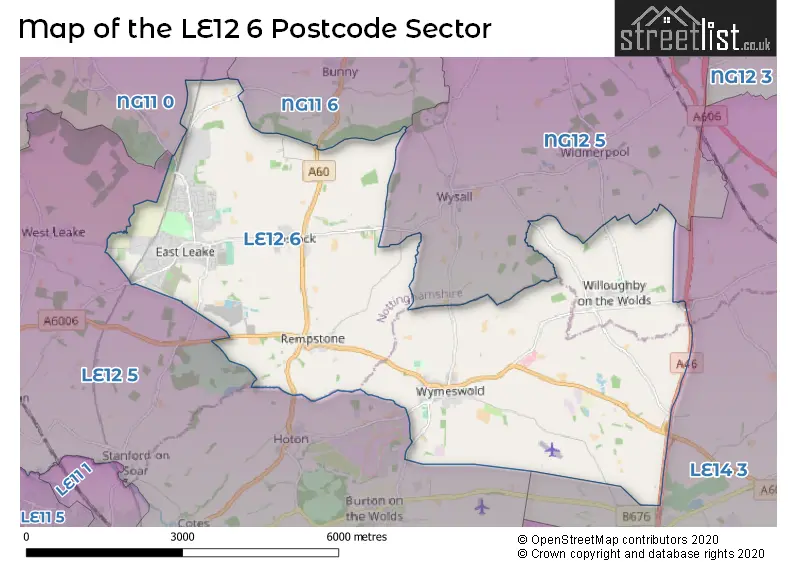
The LE12 6 postcode sector stands on the Leicestershire and Nottinghamshire border.
Did you know? According to the 2021 Census, the LE12 6 postcode sector is home to a bustling 11,511 residents!
Given that each sector allows for 400 unique postcode combinations. Letters C, I, K, M, O and V are not allowed in the last two letters of a postcode. With 254 postcodes already in use, this leaves 146 units available.
The largest settlement in the LE12 6 postal code is East Leake followed by Wymeswold, and Costock.
The LE12 6 Postcode shares a border with NG11 0 (Gotham, Ratcliffe-on-Soar, Barton-in-Fabis), NG11 6 (Ruddington, Bunny, Bradmore), NG12 5 (Keyworth, Wysall, Widmerpool), LE12 5 (Hathern, Sutton Bonington, Burton-on-the-Wolds) and LE14 3 (Asfordby, Old Dalby, Asfordby Hill).
The sector is within the post town of LOUGHBOROUGH.
LE12 6 is a postcode sector within the LE12 postcode district which is within the LE Leicester postcode area.
The Royal Mail delivery office for the LE12 6 postal sector is the Loughborough Delivery Office and Wymeswold Scale Payment Delivery Office.
The area of the LE12 6 postcode sector is 17.09 square miles which is 44.27 square kilometres or 10,939.34 square acres.
The LE12 6 postcode sector is crossed by the A46 Major A road.


Map of the LE12 6 Postcode Sector
Explore the LE12 6 postcode sector by using our free interactive map.
| L | E | 1 | 2 | - | 6 | X | X |
| L | E | 1 | 2 | Space | 6 | Letter | Letter |
Official List of Streets
East Leake (147 Streets)
Wymeswold (36 Streets)
Costock (18 Streets)
Rempstone (12 Streets)
Willoughby On The Wolds (16 Streets)
Unofficial Streets or Alternative Spellings
Widmerpool
WILLOUGHBY ROADWysall
COSTOCK ROAD REMPSTONE LANE WYMESWOLD ROADHoton
WYMESWOLD ROADBunny
BUNNY HILL GOTHAM LANEWeather Forecast for LE12 6
Press Button to Show Forecast for Sutton Bonington
| Time Period | Icon | Description | Temperature | Rain Probability | Wind |
|---|---|---|---|---|---|
| 09:00 to 12:00 | Cloudy | 8.0°C (feels like 5.0°C) | 14.00% | ENE 9 mph | |
| 12:00 to 15:00 | Light rain | 8.0°C (feels like 6.0°C) | 53.00% | E 9 mph | |
| 15:00 to 18:00 | Overcast | 8.0°C (feels like 6.0°C) | 17.00% | ENE 11 mph | |
| 18:00 to 21:00 | Overcast | 8.0°C (feels like 5.0°C) | 14.00% | NE 9 mph | |
| 21:00 to 00:00 | Overcast | 7.0°C (feels like 4.0°C) | 12.00% | NE 9 mph |
Press Button to Show Forecast for Sutton Bonington
| Time Period | Icon | Description | Temperature | Rain Probability | Wind |
|---|---|---|---|---|---|
| 00:00 to 03:00 | Overcast | 6.0°C (feels like 3.0°C) | 17.00% | NNE 7 mph | |
| 03:00 to 06:00 | Light rain | 6.0°C (feels like 2.0°C) | 55.00% | N 9 mph | |
| 06:00 to 09:00 | Heavy rain | 6.0°C (feels like 2.0°C) | 78.00% | N 9 mph | |
| 09:00 to 12:00 | Heavy rain | 7.0°C (feels like 4.0°C) | 78.00% | NNW 9 mph | |
| 12:00 to 15:00 | Heavy rain | 8.0°C (feels like 6.0°C) | 73.00% | NW 9 mph | |
| 15:00 to 18:00 | Light rain shower (day) | 10.0°C (feels like 8.0°C) | 37.00% | WNW 9 mph | |
| 18:00 to 21:00 | Partly cloudy (day) | 10.0°C (feels like 8.0°C) | 8.00% | W 7 mph | |
| 21:00 to 00:00 | Partly cloudy (night) | 7.0°C (feels like 5.0°C) | 4.00% | SW 7 mph |
Press Button to Show Forecast for Sutton Bonington
| Time Period | Icon | Description | Temperature | Rain Probability | Wind |
|---|---|---|---|---|---|
| 00:00 to 03:00 | Clear night | 6.0°C (feels like 4.0°C) | 1.00% | SSW 4 mph | |
| 03:00 to 06:00 | Clear night | 4.0°C (feels like 2.0°C) | 0.00% | SSW 4 mph | |
| 06:00 to 09:00 | Sunny day | 5.0°C (feels like 2.0°C) | 2.00% | S 4 mph | |
| 09:00 to 12:00 | Sunny day | 11.0°C (feels like 8.0°C) | 1.00% | S 9 mph | |
| 12:00 to 15:00 | Cloudy | 13.0°C (feels like 10.0°C) | 6.00% | S 11 mph | |
| 15:00 to 18:00 | Cloudy | 14.0°C (feels like 11.0°C) | 6.00% | S 11 mph | |
| 18:00 to 21:00 | Sunny day | 13.0°C (feels like 11.0°C) | 3.00% | S 9 mph | |
| 21:00 to 00:00 | Clear night | 9.0°C (feels like 7.0°C) | 2.00% | SSE 7 mph |
Press Button to Show Forecast for Sutton Bonington
| Time Period | Icon | Description | Temperature | Rain Probability | Wind |
|---|---|---|---|---|---|
| 00:00 to 03:00 | Clear night | 8.0°C (feels like 6.0°C) | 2.00% | SSE 7 mph | |
| 03:00 to 06:00 | Clear night | 7.0°C (feels like 4.0°C) | 2.00% | SE 7 mph | |
| 06:00 to 09:00 | Sunny day | 8.0°C (feels like 5.0°C) | 4.00% | ESE 7 mph | |
| 09:00 to 12:00 | Sunny day | 13.0°C (feels like 11.0°C) | 5.00% | ESE 9 mph | |
| 12:00 to 15:00 | Cloudy | 15.0°C (feels like 13.0°C) | 10.00% | SE 11 mph | |
| 15:00 to 18:00 | Partly cloudy (day) | 16.0°C (feels like 14.0°C) | 9.00% | SE 9 mph | |
| 18:00 to 21:00 | Cloudy | 15.0°C (feels like 13.0°C) | 10.00% | ESE 7 mph | |
| 21:00 to 00:00 | Cloudy | 12.0°C (feels like 10.0°C) | 9.00% | E 7 mph |
Schools and Places of Education Within the LE12 6 Postcode Sector
Costock CofE Primary School
Voluntary controlled school
Main Street, Loughborough, Leicestershire, LE12 6XD
Head: Mrs Jane Elizabeth Mellor
Ofsted Rating: Good
Inspection: 2019-01-23 (1921 days ago)
Website: Visit Costock CofE Primary School Website
Phone: 01509852084
Number of Pupils: 82
East Leake Academy
Academy converter
Lantern Lane, Loughborough, Leicestershire, LE12 6QN
Head: Mr David Vernon
Ofsted Rating: Good
Inspection: 2019-10-16 (1655 days ago)
Website: Visit East Leake Academy Website
Phone: 01509852424
Number of Pupils: 1090
Lantern Lane Primary and Nursery School
Community school
Lantern Lane, Loughborough, Leicestershire, LE12 6QN
Head: Mrs Jane Butler
Ofsted Rating: Good
Inspection: 2022-12-07 (507 days ago)
Website: Visit Lantern Lane Primary and Nursery School Website
Phone: 01509820112
Number of Pupils: 437
Willoughby Primary School
Community school
Church Lane, Loughborough, Leicestershire, LE12 6SS
Head: Mrs Joanne Linnett
Ofsted Rating: Good
Inspection: 2021-12-01 (878 days ago)
Website: Visit Willoughby Primary School Website
Phone: 01509880620
Number of Pupils: 44
Wymeswold Church of England Primary School
Voluntary controlled school
Brook Street, Loughborough, Leicestershire, LE12 6TU
Head: Mrs Jan Scallon
Ofsted Rating: Good
Inspection: 2018-12-06 (1969 days ago)
Website: Visit Wymeswold Church of England Primary School Website
Phone: 01509880561
Number of Pupils: 116
House Prices in the LE12 6 Postcode Sector
| Type of Property | 2018 Average | 2018 Sales | 2017 Average | 2017 Sales | 2016 Average | 2016 Sales | 2015 Average | 2015 Sales |
|---|---|---|---|---|---|---|---|---|
| Detached | £334,630 | 179 | £331,311 | 200 | £316,876 | 185 | £310,893 | 170 |
| Semi-Detached | £193,239 | 75 | £218,628 | 92 | £182,367 | 70 | £184,087 | 59 |
| Terraced | £200,765 | 43 | £157,750 | 28 | £180,987 | 29 | £196,622 | 16 |
| Flats | £132,929 | 7 | £128,400 | 5 | £130,369 | 8 | £111,667 | 3 |
Important Postcodes LE12 6 in the Postcode Sector
LE12 6JG is the postcode for The Health Centre, Gotham Road
LE12 6LG is the postcode for Brookside Primary School, School Green, and BROOKSIDE PRIMARY SCHOOL, SCHOOL GREEN, EAST LEAKE
LE12 6QN is the postcode for East Leake Academy, Lantern Lane, East Leake Leisure Centre, Lantern Lane, East Leake, SPORTS CENTRE, East Leake Academy, Lantern Lane, LANTERN LANE PRIMARY SCHOOL, LANTERN LANE, EAST LEAKE, East Leake Leisure Centre, Lantern Lane, Lantern Lane Primary School, Lantern Lane, MAIN SCHOOL, East Leake Academy, Lantern Lane, and MODULAR CLASSROOM, Lantern Lane Primary School, Lantern Lane
LE12 6SS is the postcode for Willoughby Primary School, Church Lane
LE12 6XD is the postcode for Costock C of E Primary School, Main Street
| The LE12 6 Sector is within these Local Authorities |
|
|---|---|
| The LE12 6 Sector is within these Counties |
|
| The LE12 6 Sector is within these Water Company Areas |
|