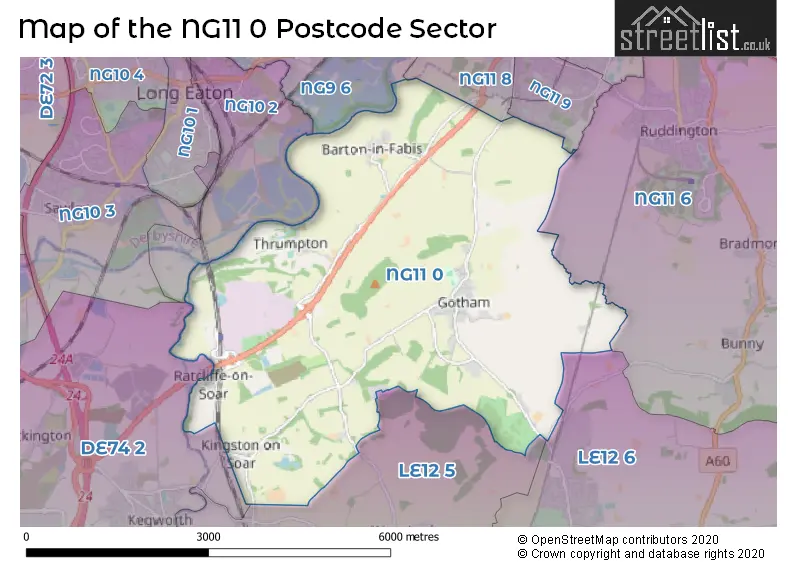
The NG11 0 postcode sector lies where the three counties of Derbyshire, Nottinghamshire, and Leicestershire meet.
Did you know? According to the 2021 Census, the NG11 0 postcode sector is home to a bustling 2,399 residents!
Given that each sector allows for 400 unique postcode combinations. Letters C, I, K, M, O and V are not allowed in the last two letters of a postcode. With 80 postcodes already in use, this leaves 320 units available.
The largest settlement in the NG11 0 postal code is Gotham followed by Ratcliffe-on-Soar, and Barton-in-Fabis.
The NG11 0 Postcode shares a border with NG11 6 (Ruddington, Bunny, Bradmore), NG11 8 (NOTTINGHAM, Clifton Village, Clifton), NG11 9 (NOTTINGHAM, Clifton), LE12 5 (Hathern, Sutton Bonington, Burton-on-the-Wolds), LE12 6 (East Leake, Wymeswold, Costock), NG9 6 (Toton, Beeston, Attenborough), NG10 2 (Long Eaton) and DE74 2 (Castle Donington, Kegworth, Diseworth).
The sector is within the post town of NOTTINGHAM.
NG11 0 is a postcode sector within the NG11 postcode district which is within the NG Nottingham postcode area.
The Royal Mail delivery office for the NG11 0 postal sector is the Gotham Scale Payment Delivery Office and Clifton (ng) Delivery Office.
The area of the NG11 0 postcode sector is 11.80 square miles which is 30.57 square kilometres or 7,554.73 square acres.
The NG11 0 postcode sector is crossed by the A453 Major A road.
Waterways within the NG11 0 postcode sector include the River Trent, River Soar, Loughborough Navigation (River Soar), Cranfleet Cut, Fairham Brook, The Backwater.

Map of the NG11 0 Postcode Sector
Explore the NG11 0 postcode sector by using our free interactive map.
| N | G | 1 | 1 | - | 0 | X | X |
| N | G | 1 | 1 | Space | 0 | Letter | Letter |
Official List of Streets
Barton-in-Fabis (8 Streets)
Thrumpton (2 Streets)
Gotham (36 Streets)
Kingston-on-Soar (10 Streets)
Ratcliffe-on-Soar (2 Streets)
Unofficial Streets or Alternative Spellings
Kegworth
STATION ROADEast Leake
BUNNY LANE GOTHAM ROADBarton-in-Fabis
OLD FARM COURT THE LIMESThrumpton
WOOD FARM COURTWeather Forecast for NG11 0
Press Button to Show Forecast for Thrumpton Hall
| Time Period | Icon | Description | Temperature | Rain Probability | Wind |
|---|---|---|---|---|---|
| 03:00 to 06:00 | Partly cloudy (night) | 12.0°C (feels like 10.0°C) | 1.00% | ENE 7 mph | |
| 06:00 to 09:00 | Cloudy | 12.0°C (feels like 11.0°C) | 4.00% | ENE 7 mph | |
| 09:00 to 12:00 | Cloudy | 17.0°C (feels like 16.0°C) | 4.00% | ENE 9 mph | |
| 12:00 to 15:00 | Partly cloudy (day) | 22.0°C (feels like 21.0°C) | 2.00% | ESE 9 mph | |
| 15:00 to 18:00 | Partly cloudy (day) | 23.0°C (feels like 21.0°C) | 9.00% | SE 11 mph | |
| 18:00 to 21:00 | Cloudy | 21.0°C (feels like 20.0°C) | 14.00% | SE 9 mph | |
| 21:00 to 00:00 | Cloudy | 17.0°C (feels like 17.0°C) | 7.00% | SE 7 mph |
Press Button to Show Forecast for Thrumpton Hall
| Time Period | Icon | Description | Temperature | Rain Probability | Wind |
|---|---|---|---|---|---|
| 00:00 to 03:00 | Partly cloudy (night) | 15.0°C (feels like 15.0°C) | 9.00% | SSE 7 mph | |
| 03:00 to 06:00 | Partly cloudy (night) | 14.0°C (feels like 13.0°C) | 8.00% | S 7 mph | |
| 06:00 to 09:00 | Cloudy | 14.0°C (feels like 12.0°C) | 9.00% | S 9 mph | |
| 09:00 to 12:00 | Cloudy | 15.0°C (feels like 14.0°C) | 8.00% | S 11 mph | |
| 12:00 to 15:00 | Cloudy | 17.0°C (feels like 15.0°C) | 14.00% | S 13 mph | |
| 15:00 to 18:00 | Cloudy | 17.0°C (feels like 14.0°C) | 17.00% | S 13 mph | |
| 18:00 to 21:00 | Cloudy | 16.0°C (feels like 14.0°C) | 24.00% | SSE 13 mph | |
| 21:00 to 00:00 | Heavy rain | 14.0°C (feels like 12.0°C) | 79.00% | SE 11 mph |
Press Button to Show Forecast for Thrumpton Hall
| Time Period | Icon | Description | Temperature | Rain Probability | Wind |
|---|---|---|---|---|---|
| 00:00 to 03:00 | Light rain | 14.0°C (feels like 12.0°C) | 58.00% | SE 11 mph | |
| 03:00 to 06:00 | Light rain | 13.0°C (feels like 12.0°C) | 52.00% | SSE 9 mph | |
| 06:00 to 09:00 | Light rain | 13.0°C (feels like 11.0°C) | 50.00% | SSE 9 mph | |
| 09:00 to 12:00 | Light rain shower (day) | 14.0°C (feels like 12.0°C) | 44.00% | SSE 11 mph | |
| 12:00 to 15:00 | Heavy rain shower (day) | 16.0°C (feels like 14.0°C) | 60.00% | SSE 13 mph | |
| 15:00 to 18:00 | Light rain shower (day) | 17.0°C (feels like 14.0°C) | 39.00% | SSE 13 mph | |
| 18:00 to 21:00 | Partly cloudy (day) | 16.0°C (feels like 14.0°C) | 14.00% | SSE 11 mph | |
| 21:00 to 00:00 | Clear night | 13.0°C (feels like 11.0°C) | 6.00% | SSE 9 mph |
Press Button to Show Forecast for Thrumpton Hall
| Time Period | Icon | Description | Temperature | Rain Probability | Wind |
|---|---|---|---|---|---|
| 00:00 to 03:00 | Clear night | 12.0°C (feels like 10.0°C) | 6.00% | SSE 9 mph | |
| 03:00 to 06:00 | Partly cloudy (night) | 11.0°C (feels like 9.0°C) | 3.00% | SSE 9 mph | |
| 06:00 to 09:00 | Cloudy | 12.0°C (feels like 10.0°C) | 5.00% | SSE 9 mph | |
| 09:00 to 12:00 | Partly cloudy (day) | 14.0°C (feels like 12.0°C) | 10.00% | SSE 11 mph | |
| 12:00 to 15:00 | Light rain shower (day) | 16.0°C (feels like 14.0°C) | 35.00% | SSE 13 mph | |
| 15:00 to 18:00 | Light rain shower (day) | 17.0°C (feels like 14.0°C) | 37.00% | S 11 mph | |
| 18:00 to 21:00 | Light rain shower (day) | 16.0°C (feels like 14.0°C) | 35.00% | S 9 mph | |
| 21:00 to 00:00 | Clear night | 13.0°C (feels like 11.0°C) | 4.00% | S 7 mph |
Schools and Places of Education Within the NG11 0 Postcode Sector
Gotham Primary School
Community school
Kegworth Road, Nottingham, Nottinghamshire, NG11 0JS
Head: Miss Janette Allen
Ofsted Rating: Good
Inspection: 2022-07-13 (669 days ago)
Website: Visit Gotham Primary School Website
Phone: 01159149751
Number of Pupils: 161
House Prices in the NG11 0 Postcode Sector
| Type of Property | 2018 Average | 2018 Sales | 2017 Average | 2017 Sales | 2016 Average | 2016 Sales | 2015 Average | 2015 Sales |
|---|---|---|---|---|---|---|---|---|
| Detached | £336,589 | 14 | £321,933 | 23 | £383,167 | 12 | £310,353 | 17 |
| Semi-Detached | £188,447 | 15 | £203,077 | 13 | £187,964 | 14 | £195,133 | 18 |
| Terraced | £181,500 | 9 | £203,325 | 6 | £177,700 | 5 | £204,272 | 9 |
| Flats | £0 | 0 | £390,000 | 2 | £0 | 0 | £0 | 0 |
Important Postcodes NG11 0 in the Postcode Sector
NG11 0JS is the postcode for GOTHAM PRIMARY SCHOOL, KEGWORTH ROAD, GOTHAM, Gotham Primary School, Kegworth Road, and Gotham Cp School, Kegworth Road
| The NG11 0 Sector is within these Local Authorities |
|
|---|---|
| The NG11 0 Sector is within these Counties |
|
| The NG11 0 Sector is within these Water Company Areas |
|