The NG11 postcode district is a postal district located in the NG Nottingham postcode area with a population of 39,041 residents according to the 2021 England and Wales Census.
The area of the NG11 postcode district is 25.38 square miles which is 65.73 square kilometres or 16,241.45 acres.
Currently, the NG11 district has about 847 postcode units spread across 5 geographic postcode sectors.
Given that each sector allows for 400 unique postcode combinations, the district has a capacity of 2,000 postcodes. With 847 postcodes already in use, this leaves 1153 units available.
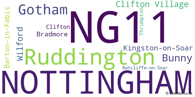
The largest settlement in the NG11 postal code is NOTTINGHAM followed by Ruddington, and Gotham.
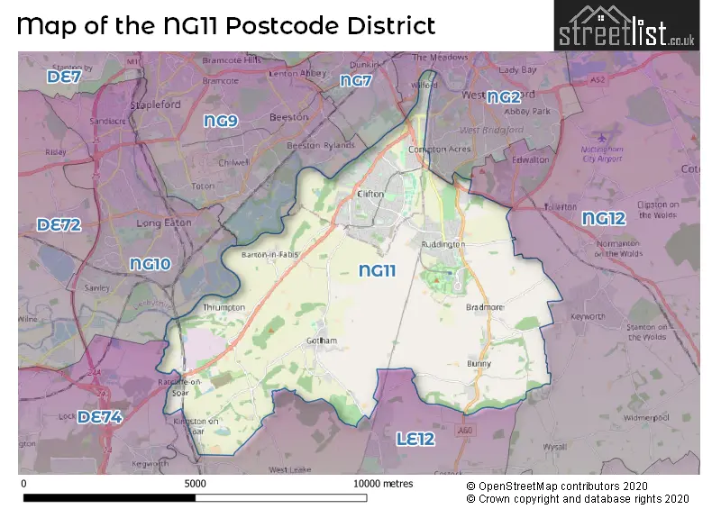
The NG11 Postcode shares a border with LE12 (Shepshed, Sileby, Mountsorrel), NG10 (Long Eaton, Sandiacre), DE74 (Castle Donington, Kegworth, Diseworth), NG9 (Beeston, Stapleford, Bramcote), NG2 (West Bridgford, NOTTINGHAM, Gamston) and NG12 (Radcliffe-on-Trent, Keyworth, Cotgrave).
The primary settlement in the NG11 postcode district is Nottingham, located in the county of Nottinghamshire, in England. Other significant settlements in the district include Gotham, Kingston-on-Soar, Ratcliffe-on-Soar, Thrumpton, Bradmore, and Bunny. The most significant post town in the NG11 postcode district is Nottingham.
For the district NG11, we have data on 6 postcode sectors. Here's a breakdown: The sector NG11 0, covers Gotham and Kingston-On-Soar and Barton-In-Fabis in Nottinghamshire. The sector NG11 1 is non-geographic. It's often designated for PO Boxes, large organisations, or special services. The sector NG11 6, covers Ruddington and Bunny in Nottinghamshire. The sector NG11 7, covers Nottingham and Wilford in Nottinghamshire. The sector NG11 8, covers Nottingham in Nottinghamshire. The sector NG11 9, covers Nottingham in Nottinghamshire.

Map of the NG11 Postcode District
Explore the NG11 postcode district by using our free interactive map.
When it comes to local government, postal geography often disregards political borders. However, for a breakdown in the NG11 District: the district mostly encompasses the City of Nottingham (B) (559 postcodes), and finally, the Rushcliffe District (B) area (319 postcodes).
Recent House Sales in NG11
| Date | Price | Address |
|---|---|---|
| 29/09/2023 | £370,000 | Hockerwood, Nottingham, NG11 8PG |
| 22/09/2023 | £380,000 | Cornflower Crescent, Ruddington, Nottingham, NG11 6SG |
| 22/09/2023 | £380,000 | St Mawes Avenue, Nottingham, NG11 7BW |
| 22/09/2023 | £215,000 | Shrimpton Court, Ruddington, Nottingham, NG11 6GY |
| 22/09/2023 | £235,000 | Dovenby Road, Clifton, Nottingham, NG11 8JL |
| 08/09/2023 | £197,500 | Brandish Crescent, Clifton, Nottingham, NG11 9JZ |
| 08/09/2023 | £185,000 | Meadowvale Crescent, Clifton, Nottingham, NG11 9LY |
| 08/09/2023 | £285,000 | Asher Lane, Ruddington, Nottingham, NG11 6HS |
| 05/09/2023 | £185,000 | Failsworth Close, Clifton, Nottingham, NG11 8FN |
| 01/09/2023 | £185,000 | Belwood Close, Clifton, Nottingham, NG11 8HZ |
Where is the NG11 Postcode District?
The data shows that the NG11 postcode district is located in the town of Nottingham. Nearby towns include Loughborough to the South, Ilkeston to the North West, Coalville to the South West, Derby to the West, and Melton Mowbray to the South East. The distance from NG11 to the center of London is approximately 104.8 miles.
The district is within the post town of NOTTINGHAM.
The sector has postcodes within the nation of England.
The NG11 Postcode District is covers the following regions.
- South Nottinghamshire - Derbyshire and Nottinghamshire - East Midlands (England)
- Nottingham - Derbyshire and Nottinghamshire - East Midlands (England)
- North Nottinghamshire - Derbyshire and Nottinghamshire - East Midlands (England)
Weather Forecast for NG11
Press Button to Show Forecast for Clifton (Nottingham)
| Time Period | Icon | Description | Temperature | Rain Probability | Wind |
|---|---|---|---|---|---|
| 18:00 to 21:00 | Cloudy | 20.0°C (feels like 17.0°C) | 3.00% | E 11 mph | |
| 21:00 to 00:00 | Cloudy | 16.0°C (feels like 15.0°C) | 3.00% | E 9 mph |
Press Button to Show Forecast for Clifton (Nottingham)
| Time Period | Icon | Description | Temperature | Rain Probability | Wind |
|---|---|---|---|---|---|
| 00:00 to 03:00 | Partly cloudy (night) | 13.0°C (feels like 12.0°C) | 1.00% | ENE 7 mph | |
| 03:00 to 06:00 | Partly cloudy (night) | 12.0°C (feels like 10.0°C) | 1.00% | NE 7 mph | |
| 06:00 to 09:00 | Cloudy | 12.0°C (feels like 11.0°C) | 4.00% | NE 7 mph | |
| 09:00 to 12:00 | Cloudy | 17.0°C (feels like 16.0°C) | 3.00% | ENE 9 mph | |
| 12:00 to 15:00 | Cloudy | 22.0°C (feels like 21.0°C) | 8.00% | ESE 9 mph | |
| 15:00 to 18:00 | Cloudy | 23.0°C (feels like 21.0°C) | 10.00% | SE 11 mph | |
| 18:00 to 21:00 | Cloudy | 21.0°C (feels like 20.0°C) | 15.00% | SE 9 mph | |
| 21:00 to 00:00 | Cloudy | 18.0°C (feels like 17.0°C) | 7.00% | ESE 7 mph |
Press Button to Show Forecast for Clifton (Nottingham)
| Time Period | Icon | Description | Temperature | Rain Probability | Wind |
|---|---|---|---|---|---|
| 00:00 to 03:00 | Partly cloudy (night) | 15.0°C (feels like 15.0°C) | 9.00% | SE 4 mph | |
| 03:00 to 06:00 | Partly cloudy (night) | 14.0°C (feels like 13.0°C) | 7.00% | S 4 mph | |
| 06:00 to 09:00 | Overcast | 14.0°C (feels like 13.0°C) | 13.00% | S 7 mph | |
| 09:00 to 12:00 | Cloudy | 16.0°C (feels like 14.0°C) | 8.00% | S 11 mph | |
| 12:00 to 15:00 | Cloudy | 18.0°C (feels like 15.0°C) | 11.00% | S 13 mph | |
| 15:00 to 18:00 | Cloudy | 18.0°C (feels like 15.0°C) | 17.00% | S 13 mph | |
| 18:00 to 21:00 | Overcast | 17.0°C (feels like 14.0°C) | 25.00% | SSE 11 mph | |
| 21:00 to 00:00 | Light rain | 15.0°C (feels like 13.0°C) | 58.00% | SE 11 mph |
Press Button to Show Forecast for Clifton (Nottingham)
| Time Period | Icon | Description | Temperature | Rain Probability | Wind |
|---|---|---|---|---|---|
| 00:00 to 03:00 | Heavy rain | 14.0°C (feels like 12.0°C) | 80.00% | SE 11 mph | |
| 03:00 to 06:00 | Light rain | 13.0°C (feels like 12.0°C) | 55.00% | SSE 9 mph | |
| 06:00 to 09:00 | Light rain | 13.0°C (feels like 12.0°C) | 53.00% | SSE 7 mph | |
| 09:00 to 12:00 | Light rain | 14.0°C (feels like 13.0°C) | 54.00% | SSE 9 mph | |
| 12:00 to 15:00 | Heavy rain shower (day) | 16.0°C (feels like 14.0°C) | 59.00% | SSE 11 mph | |
| 15:00 to 18:00 | Light rain shower (day) | 17.0°C (feels like 15.0°C) | 40.00% | SSE 13 mph | |
| 18:00 to 21:00 | Light rain shower (day) | 16.0°C (feels like 14.0°C) | 37.00% | SSE 11 mph | |
| 21:00 to 00:00 | Clear night | 14.0°C (feels like 12.0°C) | 9.00% | SSE 9 mph |
Press Button to Show Forecast for Clifton (Nottingham)
| Time Period | Icon | Description | Temperature | Rain Probability | Wind |
|---|---|---|---|---|---|
| 00:00 to 03:00 | Clear night | 12.0°C (feels like 11.0°C) | 6.00% | SSE 9 mph | |
| 03:00 to 06:00 | Partly cloudy (night) | 11.0°C (feels like 10.0°C) | 6.00% | SSE 7 mph | |
| 06:00 to 09:00 | Cloudy | 12.0°C (feels like 10.0°C) | 5.00% | SSE 9 mph | |
| 09:00 to 12:00 | Partly cloudy (day) | 14.0°C (feels like 12.0°C) | 11.00% | SSE 11 mph | |
| 12:00 to 15:00 | Light rain shower (day) | 16.0°C (feels like 14.0°C) | 35.00% | SSE 11 mph | |
| 15:00 to 18:00 | Light rain shower (day) | 17.0°C (feels like 15.0°C) | 35.00% | S 11 mph | |
| 18:00 to 21:00 | Light rain shower (day) | 16.0°C (feels like 14.0°C) | 36.00% | S 9 mph | |
| 21:00 to 00:00 | Clear night | 14.0°C (feels like 13.0°C) | 6.00% | SSE 7 mph |
| Postcode Sector | Delivery Office |
|---|---|
| NG11 0 | Gotham Scale Payment Delivery Office |
| NG11 0 | Clifton (ng) Delivery Office |
| NG11 6 | Clifton (ng) Delivery Office |
| NG11 7 | Clifton (ng) Delivery Office |
| NG11 8 | Clifton (ng) Delivery Office |
| NG11 9 | Clifton (ng) Delivery Office |
| N | G | 1 | 1 | - | X | X | X |
| N | G | 1 | 1 | Space | Numeric | Letter | Letter |
Tourist Attractions within the NG11 Postcode Area
We found 1 visitor attractions within the NG11 postcode area
| Great Central Railway - Nottingham |
|---|
| Railways |
| Steam / Heritage Railway |
| View Great Central Railway - Nottingham on Google Maps |
Current Monthly Rental Prices
| # Bedrooms | Min Price | Max Price | Avg Price |
|---|---|---|---|
| £917 | £917 | £917 | |
| 1 | £500 | £1,400 | £896 |
| 2 | £850 | £1,100 | £980 |
| 3 | £975 | £1,285 | £1,070 |
| 4 | £416 | £1,000 | £612 |
| 5 | £455 | £477 | £462 |
Current House Prices
| # Bedrooms | Min Price | Max Price | Avg Price |
|---|---|---|---|
| £35,000 | £125,000 | £80,000 | |
| 1 | £99,950 | £285,950 | £190,543 |
| 2 | £60,000 | £450,000 | £237,782 |
| 3 | £106,000 | £800,000 | £288,550 |
| 4 | £325,000 | £1,250,000 | £536,348 |
| 5 | £195,000 | £1,400,000 | £749,989 |
| 6 | £800,000 | £895,000 | £847,500 |
| 7 | £1,500,000 | £1,500,000 | £1,500,000 |
Estate Agents who Operate in the NG11 District
| Logo | Name | Brand Name | Address | Contact Number | Total Properties |
|---|---|---|---|---|---|
 | Ruddington | Thomas James Estate Agents | 20 High Street, Ruddington, Nottingham, NG11 6EH | 0115 647 8056 | 50 |
 | Clifton | Bairstow Eves | 238 Southchurch Drive, Nottingham, Nottinghamshire, NG11 8AA | 0115 647 0927 | 41 |
 | Ruddington | Benjamins | 2E High Street, Ruddington, Nottingham, NG11 6EH | 0115 647 9500 | 20 |
 | Keyworth | Royston & Lund Estate Agents | 7 The Square, Keyworth, NG12 5JT | 0115 647 8877 | 11 |
 | West Bridgford | HoldenCopley | 2 Tudor Square, West Bridgford, Nottingham, NG2 6BT | 0115 647 7288 | 11 |
Yearly House Price Averages for the NG11 Postcode District
| Type of Property | 2018 Average | 2018 Sales | 2017 Average | 2017 Sales | 2016 Average | 2016 Sales | 2015 Average | 2015 Sales |
|---|---|---|---|---|---|---|---|---|
| Detached | £343,581 | 133 | £374,169 | 158 | £316,299 | 144 | £331,748 | 144 |
| Semi-Detached | £181,461 | 204 | £182,132 | 228 | £164,732 | 233 | £159,623 | 198 |
| Terraced | £149,098 | 249 | £146,620 | 220 | £130,177 | 281 | £125,929 | 256 |
| Flats | £140,684 | 35 | £146,292 | 40 | £125,194 | 43 | £121,283 | 39 |