This section of the site is all about the NN Postcode area, also known as the Northampton Postal Area. Explore links to the next level to learn more about specific postcode districts such as NN1.
The NN postcode area represents a group of postal districts in the Northampton area of the United Kingdom. The area code NN stands for the letters n and n in NorthamptoN. NN has a population of 653,215 and covers an area of 1,897,836 hectares. Fun fact: 1.00% of the population of Great Britain lives in this area.
The postcode area falls within the following counties: Northamptonshire (99.48%), Buckinghamshire (0.19%), Bedfordshire (0.18%), Oxfordshire (0.09%), Warwickshire (0.05%), Leicestershire (0.01%).
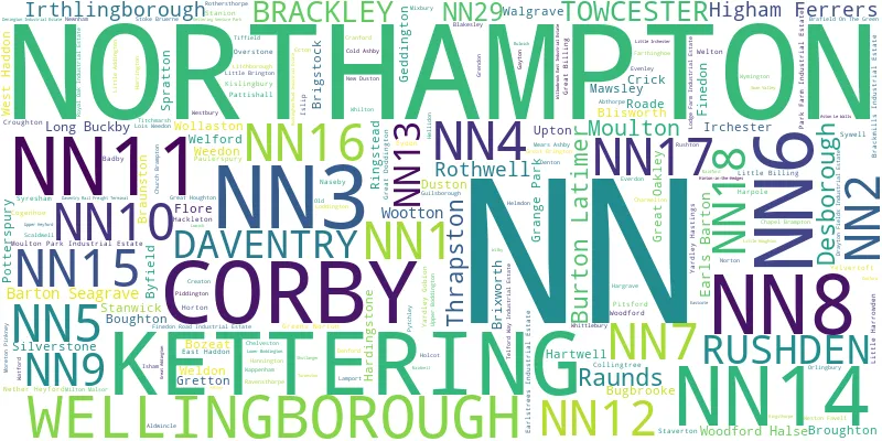
Post Towns and Postcode Districts for the NN Postcode
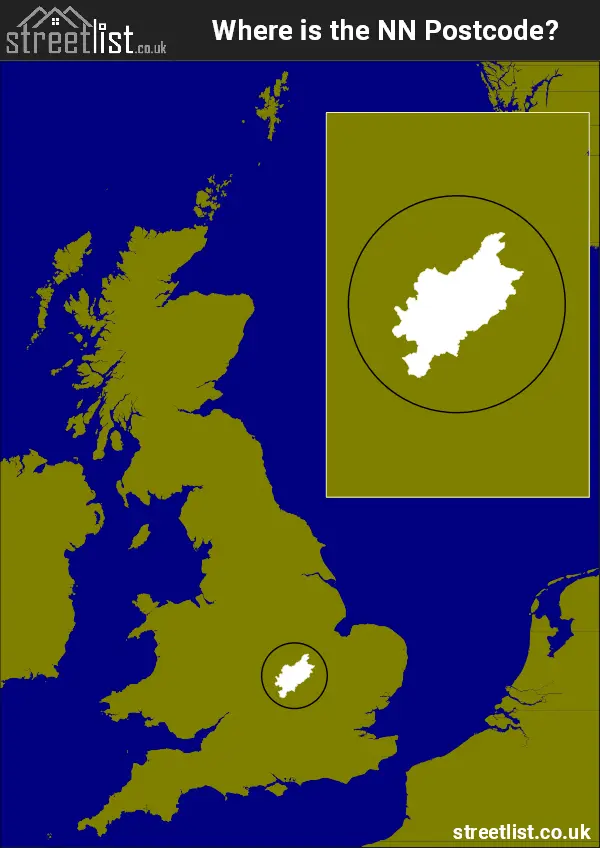
Where is the NN Postcode Area?
The NN Northampton,Postcode is in the East Midlands Region. The postal area borders the following neighbouring postal areas: CV - Coventry, LE - Leicester, PE - Peterborough, OX - Oxford and MK - Milton Keynes, and is located inland.
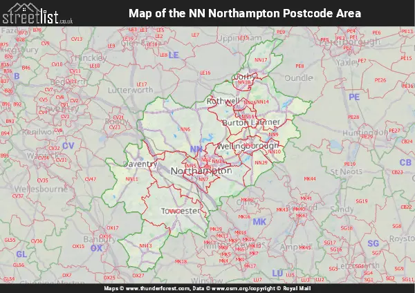
Map of the NN Northampton Postcode Area
Explore the NN Northampton postcode area by using our interactive map.
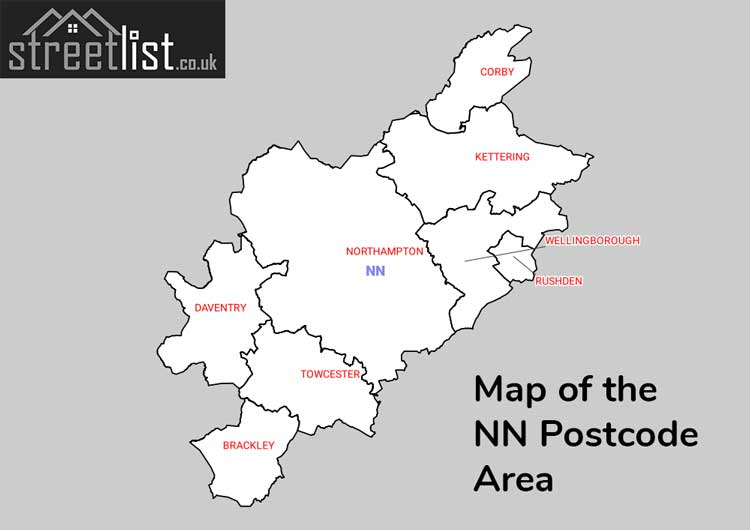
Postcode Districts within the NN Northampton Postcode Area
There are 19 postcode districts within the Northampton postcode area
A map showing the boundary of in relation to other areas
There are 14 towns within the Northampton postcode area.
| Unit | Area² |
|---|---|
| Hectares | 1,897,836² |
| Miles | 7,328² |
| Feet | 204,281,169,204² |
| Kilometres | 18,978² |
Postal Delivery Offices serving the NN Northampton Postcode Area
- Badby Scale Payment Delivery Office
- Blakesley Scale Payment Delivery Office
- Bozeat Scale Payment Delivery Office
- Brackley Delivery Office
- Brafield-on-the-green Scale Payment Delivery Office
- Braunston Scale Payment Delivery Office
- Bugbrooke Scale Payment Delivery Office
- Charwelton Scale Payment Delivery Office
- Cogenhoe Scale Payment Delivery Office
- Corby Delivery Office
- Creaton Scale Payment Delivery Office
- Crick Scale Payment Delivery Office
- Daventry Delivery Office
- Earls Barton Scale Payment Delivery Office
- Ecton Wayside Office
- Ever Delivery Office N Scale Payment Delivery Office
- Fine Delivery Office N Scale Payment Delivery Office
- Flore Scale Payment Delivery Office
- Greens Norton Scale Payment Delivery Office
- Guilsborough Scale Payment Delivery Office
- Hanging Houghton Scale Payment Delivery Office
- Irchester Scale Payment Delivery Office
- Kettering Delivery Office
- Kislingbury Scale Payment Delivery Office
- Little Houghton Scale Payment Delivery Office
- Long Buckby Scale Payment Delivery Office
- Moulton (nn3) Scale Payment Delivery Office
- Naseby Scale Payment Delivery Office
- Nether Heyford Scale Payment Delivery Office
- Newnham Scale Payment Delivery Office
- Northampton Central Delivery Office
- Northampton East Nn3a Delivery Office
- Northampton East Nn3b Delivery Office
- Northampton North Delivery Office
- Northampton Rurals Delivery Office
- Northampton South Nn4a Delivery Office
- Northampton South Nn4b Delivery Office
- Northampton West Delivery Office
- Overstone Scale Payment Delivery Office
- Pattishall Scale Payment Delivery Office
- Potterspury Scale Payment Delivery Office
- Raunds Scale Payment Delivery Office
- Rushden Delivery Office
- Silverstone Scale Payment Delivery Office
- Spratton Scale Payment Delivery Office
- Stanwick Scale Payment Delivery Office
- Staverton Scale Payment Delivery Office
- Towcester Scale Payment Delivery Office
- Upper Boddington Scale Payment Delivery Office
- Walgrave Scale Payment Delivery Office
- Wappenham Scale Payment Delivery Office
- Watford (nn6) Scale Payment Delivery Office
- Wee Delivery Office N Scale Payment Delivery Office
- Welford Scale Payment Delivery Office
- Wellingborough Delivery Office
- West Had Delivery Office N Scale Payment Delivery Office
- Wollaston Scale Payment Delivery Office
- Woodford Halse Scale Payment Delivery Office
- Yardley Gobion Scale Payment Delivery Office
- Yardley Hastings Scale Payment Delivery Office
- Yelvertoft Scale Payment Delivery Office
Councils with Postcodes in NN
Towns and Villages within the NN Northampton Postcode Area
- Abthorpe - village
- Adstone - village
- Alderton - village
- Aldwincle - village
- Ashton - village
- Astcote - village
- Aston le Walls - village
- Badby - village
- Blakesley - village
- Blisworth - village
- Boughton - village
- Bozeat - village
- Brackley - town
- Bradden - village
- Brafield-on-the-Green - village
- Braunston - village
- Brigstock - village
- Brixworth - village
- Broughton - village
- Bugbrooke - village
- Bulwick - village
- Burton Latimer - town
- Byfield - village
- Castle Ashby - village
- Chapel Brampton - village
- Charwelton - village
- Chelveston - village
- Church Brampton - village
- Clopton - village
- Cogenhoe - village
- Cold Ashby - village
- Collingtree - village
- Corby - town
- Cottesbrooke - village
- Cottisford - village
- Courteenhall - village
- Cranford St Andrew - village
- Cranford St John - village
- Creaton - village
- Crick - village
- Croughton - village
- Daventry - town
- Denford - village
- Denton - village
- Desborough - town
- Dodford - village
- Earls Barton - village
- East Haddon - village
- Eastcote - village
- Ecton - village
- Evenley - village
- Everdon - village
- Eydon - village
- Farthinghoe - village
- Farthingstone - village
- Finedon - village
- Flore - village
- Gayton - village
- Geddington - village
- Grafton Regis - village
- Great Addington - village
- Great Brington - village
- Great Cransley - village
- Great Doddington - village
- Great Harrowden - village
- Great Houghton - village
- Greens Norton - village
- Grendon - village
- Gretton - village
- Grimscote - village
- Guilsborough - village
- Hackleton - village
- Hanging Houghton - village
- Hannington - village
- Hargrave - village
- Harlestone - village
- Harpole - village
- Harrington - village
- Harringworth - village
- Hartwell - village
- Haselbech - village
- Hellidon - village
- Helmdon - village
- Higham Ferrers - town
- Hinton - village
- Hinton-in-the-Hedges - village
- Holcot - village
- Hollowell - village
- Horton - village
- Irchester - village
- Irthlingborough - town
- Isham - village
- Islip - village
- Kelmarsh - village
- Kettering - town
- Kislingbury - village
- Lamport - village
- Laxton - village
- Litchborough - village
- Little Addington - village
- Little Brington - village
- Little Harrowden - village
- Little Houghton - village
- Little Irchester - village
- Little Wymington - village
- Loddington - village
- Long Buckby - village
- Long Buckby Wharf - village
- Lower Boddington - village
- Lowick - village
- Maidford - village
- Maidwell - village
- Mawsley Village - village
- Mears Ashby - village
- Milthorpe - village
- Milton Malsor - village
- Mixbury - village
- Moreton Pinkney - village
- Moulton - village
- Naseby - village
- Nether Heyford - village
- Newnham - village
- Northampton - town
- Norton - village
- Old - village
- Orlingbury - village
- Overstone - village
- Pattishall - village
- Paulerspury - village
- Piddington - village
- Pitsford - village
- Podington - village
- Potterspury - village
- Preston Capes - village
- Pury End - village
- Pytchley - village
- Quinton - village
- Raunds - town
- Ravensthorpe - village
- Ringstead - village
- Roade - village
- Rothersthorpe - village
- Rothwell - village
- Rushden - town
- Rushton - village
- Scaldwell - village
- Shutlanger - village
- Silverstone - village
- Slapton - village
- Slipton - village
- Spratton - village
- Stanford on Avon - otherSettlement
- Stanion - village
- Stanwick - village
- Staverton - village
- Stoke Bruerne - village
- Sudborough - village
- Swan Valley - otherSettlement
- Syresham - village
- Sywell - village
- Thornby - village
- Thorpe Malsor - village
- Thrapston - town
- Tiffield - village
- Titchmarsh - village
- Towcester - town
- Turweston - village
- Upper Boddington - village
- Walgrave - village
- Wappenham - village
- Warkton - village
- Watford - village
- Weedon Bec - village
- Weedon Lois - village
- Weekley - village
- Weldon - village
- Welford - village
- Wellingborough - town
- Welton - village
- West Haddon - village
- Westbury - village
- Weston - village
- Whilton - village
- Whitfield - village
- Whittlebury - village
- Wilby - village
- Wollaston - village
- Woodend - village
- Woodford - village
- Woodford Halse - village
- Wymington - village
- Yardley Gobion - village
- Yardley Hastings - village
- Yelvertoft - village