The NN9 postcode district is a postal district located in the NN Northampton postcode area with a population of 29,037 residents according to the 2021 England and Wales Census.
The area of the NN9 postcode district is 31.22 square miles which is 80.86 square kilometres or 19,980.55 acres.
Currently, the NN9 district has about 651 postcode units spread across 2 geographic postcode sectors.
Given that each sector allows for 400 unique postcode combinations, the district has a capacity of 800 postcodes. With 651 postcodes already in use, this leaves 149 units available.
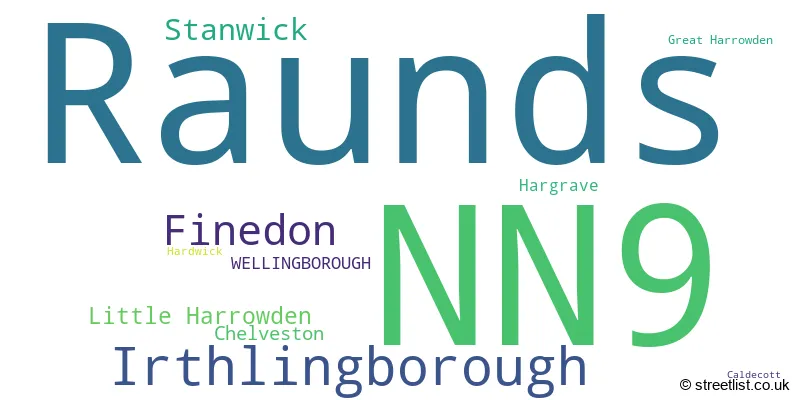
The largest settlement in the NN9 postal code is Raunds followed by Irthlingborough, and Finedon.
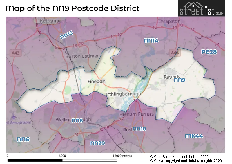
The NN9 Postcode shares a border with PE28 (Brampton, Sawtry, Warboys), NN14 (Desborough, Rothwell, Thrapston), NN10 (RUSHDEN, Higham Ferrers, Wymington), NN15 (KETTERING, Burton Latimer, Barton Seagrave), NN6 (Earls Barton, Brixworth, Long Buckby) and NN8 (WELLINGBOROUGH, Finedon Road Industrial Estate, Wilby).
The primary settlement in the NN9 postcode district is Irthlingborough, which is located in Wellingborough, Northamptonshire. The other significant settlements in this postcode district include Finedon, Little Harrowden, and Great Harrowden. NN9 is associated with the post town of Wellingborough, which is situated in Northamptonshire, England.
For the district NN9, we have data on 2 postcode sectors. Here's a breakdown: The sector NN9 5, covers Irthlingborough and Finedon in Northamptonshire. The sector NN9 6, covers Raunds and Stanwick in Northamptonshire.

Map of the NN9 Postcode District
Explore the NN9 postcode district by using our free interactive map.
When it comes to local government, postal geography often disregards political borders. However, for a breakdown in the NN9 District: the district mostly encompasses the North Northamptonshire area with a total of 669 postcodes.
Recent House Sales in NN9
| Date | Price | Address |
|---|---|---|
| 20/10/2023 | £222,000 | Garrow Close, Irthlingborough, Wellingborough, NN9 5EG |
| 12/10/2023 | £677,000 | Hardwick Village, Hardwick, Wellingborough, NN9 5AL |
| 06/10/2023 | £137,500 | Queen Street, Irthlingborough, Wellingborough, NN9 5RW |
| 25/09/2023 | £245,000 | Allen Road, Finedon, Wellingborough, NN9 5EN |
| 25/09/2023 | £225,000 | Hawthorne Road, Finedon, Wellingborough, NN9 5DR |
| 20/09/2023 | £245,000 | Park Street, Raunds, Wellingborough, NN9 6NB |
| 15/09/2023 | £242,500 | Gulliver Road, Irthlingborough, Wellingborough, NN9 5GR |
| 08/09/2023 | £675,000 | Raunds Road, Stanwick, Wellingborough, NN9 6PP |
| 07/09/2023 | £700,000 | Church Street, Finedon, Wellingborough, NN9 5NA |
| 04/09/2023 | £285,000 | Main Street, Little Harrowden, Wellingborough, NN9 5BB |
Weather Forecast for NN9
Press Button to Show Forecast for Raunds
| Time Period | Icon | Description | Temperature | Rain Probability | Wind |
|---|---|---|---|---|---|
| 00:00 to 03:00 | Cloudy | 5.0°C (feels like 3.0°C) | 6.00% | ENE 7 mph | |
| 03:00 to 06:00 | Cloudy | 5.0°C (feels like 2.0°C) | 10.00% | NE 7 mph | |
| 06:00 to 09:00 | Cloudy | 5.0°C (feels like 2.0°C) | 10.00% | NE 9 mph | |
| 09:00 to 12:00 | Overcast | 8.0°C (feels like 5.0°C) | 42.00% | ENE 11 mph | |
| 12:00 to 15:00 | Overcast | 9.0°C (feels like 6.0°C) | 18.00% | NE 11 mph | |
| 15:00 to 18:00 | Overcast | 9.0°C (feels like 6.0°C) | 16.00% | NE 11 mph | |
| 18:00 to 21:00 | Overcast | 8.0°C (feels like 5.0°C) | 14.00% | NE 13 mph | |
| 21:00 to 00:00 | Overcast | 7.0°C (feels like 4.0°C) | 51.00% | NNE 13 mph |
Press Button to Show Forecast for Raunds
| Time Period | Icon | Description | Temperature | Rain Probability | Wind |
|---|---|---|---|---|---|
| 00:00 to 03:00 | Heavy rain | 7.0°C (feels like 4.0°C) | 83.00% | NNE 13 mph | |
| 03:00 to 06:00 | Heavy rain | 7.0°C (feels like 3.0°C) | 90.00% | NNE 16 mph | |
| 06:00 to 09:00 | Heavy rain | 7.0°C (feels like 3.0°C) | 92.00% | N 13 mph | |
| 09:00 to 12:00 | Heavy rain | 7.0°C (feels like 4.0°C) | 81.00% | NNW 11 mph | |
| 12:00 to 15:00 | Light rain | 8.0°C (feels like 5.0°C) | 50.00% | NW 13 mph | |
| 15:00 to 18:00 | Cloudy | 9.0°C (feels like 7.0°C) | 16.00% | WNW 11 mph | |
| 18:00 to 21:00 | Cloudy | 10.0°C (feels like 8.0°C) | 9.00% | WSW 7 mph | |
| 21:00 to 00:00 | Partly cloudy (night) | 7.0°C (feels like 5.0°C) | 3.00% | SW 7 mph |
Press Button to Show Forecast for Raunds
| Time Period | Icon | Description | Temperature | Rain Probability | Wind |
|---|---|---|---|---|---|
| 00:00 to 03:00 | Clear night | 6.0°C (feels like 3.0°C) | 2.00% | SW 7 mph | |
| 03:00 to 06:00 | Clear night | 4.0°C (feels like 2.0°C) | 1.00% | SSW 7 mph | |
| 06:00 to 09:00 | Sunny day | 5.0°C (feels like 3.0°C) | 1.00% | S 7 mph | |
| 09:00 to 12:00 | Partly cloudy (day) | 11.0°C (feels like 9.0°C) | 2.00% | S 11 mph | |
| 12:00 to 15:00 | Cloudy | 13.0°C (feels like 11.0°C) | 5.00% | S 11 mph | |
| 15:00 to 18:00 | Partly cloudy (day) | 14.0°C (feels like 12.0°C) | 1.00% | S 11 mph | |
| 18:00 to 21:00 | Sunny day | 13.0°C (feels like 11.0°C) | 1.00% | S 9 mph | |
| 21:00 to 00:00 | Clear night | 9.0°C (feels like 7.0°C) | 1.00% | SSE 9 mph |
Press Button to Show Forecast for Raunds
| Time Period | Icon | Description | Temperature | Rain Probability | Wind |
|---|---|---|---|---|---|
| 00:00 to 03:00 | Clear night | 7.0°C (feels like 5.0°C) | 2.00% | SE 7 mph | |
| 03:00 to 06:00 | Clear night | 6.0°C (feels like 4.0°C) | 3.00% | SE 7 mph | |
| 06:00 to 09:00 | Sunny day | 8.0°C (feels like 6.0°C) | 3.00% | ESE 7 mph | |
| 09:00 to 12:00 | Partly cloudy (day) | 13.0°C (feels like 11.0°C) | 3.00% | ESE 9 mph | |
| 12:00 to 15:00 | Cloudy | 15.0°C (feels like 13.0°C) | 19.00% | SE 11 mph | |
| 15:00 to 18:00 | Cloudy | 16.0°C (feels like 14.0°C) | 9.00% | ESE 9 mph | |
| 18:00 to 21:00 | Cloudy | 15.0°C (feels like 13.0°C) | 9.00% | ESE 9 mph | |
| 21:00 to 00:00 | Cloudy | 11.0°C (feels like 10.0°C) | 14.00% | E 7 mph |
Where is the NN9 Postcode District?
The postcode district NN9 is located in Wellingborough. This district is nearby several towns, including Rushden to the south (at a distance of 3.64 miles), Kettering to the northwest (at a distance of 7.21 miles), Corby to the north (at a distance of 11.33 miles), Northampton to the southwest (at a distance of 13.60 miles), St. Neots to the southeast (at a distance of 16.80 miles), and Huntingdon to the east (at a distance of 17.41 miles). Additionally, NN9 is approximately 60.65 miles away from the center of London.
The district is within the post town of WELLINGBOROUGH.
The sector has postcodes within the nation of England.
The NN9 Postcode District is covers the following regions.
- North Northamptonshire - Leicestershire, Rutland and Northamptonshire - East Midlands (England)
- Bedford - Bedfordshire and Hertfordshire - East of England
| Postcode Sector | Delivery Office |
|---|---|
| NN9 5 | Finedelivery Officen Scale Payment Delivery Office |
| NN9 5 | Wellingborough Delivery Office |
| NN9 6 | Wellingborough Delivery Office |
| NN9 6 | Raunds Scale Payment Delivery Office |
| NN9 6 | Stanwick Scale Payment Delivery Office |
| N | N | 9 | - | X | X | X |
| N | N | 9 | Space | Numeric | Letter | Letter |
Current Monthly Rental Prices
| # Bedrooms | Min Price | Max Price | Avg Price |
|---|---|---|---|
| 1 | £515 | £580 | £548 |
| 2 | £775 | £1,200 | £909 |
| 3 | £995 | £1,300 | £1,123 |
| 4 | £2,000 | £3,250 | £2,483 |
Current House Prices
| # Bedrooms | Min Price | Max Price | Avg Price |
|---|---|---|---|
| £25,000 | £19,000,000 | £3,894,000 | |
| 1 | £85,000 | £235,000 | £146,249 |
| 2 | £95,000 | £465,000 | £231,097 |
| 3 | £210,000 | £595,000 | £289,200 |
| 4 | £230,000 | £1,750,000 | £443,431 |
| 5 | £390,000 | £1,700,000 | £773,999 |
| 6 | £369,000 | £850,000 | £529,333 |
Estate Agents who Operate in the NN9 District
| Logo | Name | Brand Name | Address | Contact Number | Total Properties |
|---|---|---|---|---|---|
 | Irthlingborough | Richard James Estate Agents | 28 High Street, Irthlingborough, NN9 5TN | 01933 823119 | 38 |
 | Raunds | Magenta Estate Agents | 12 The Square, Raunds, NN9 6HP | 01933 823228 | 30 |
 | Raunds | William H. Brown | 57 Brook Street, Raunds, NN9 6LL | 01933 823207 | 24 |
 | Raunds | Frosty Fields | 11 Manor Street, Raunds, NN9 6JW | 01933 825154 | 17 |
 | Kettering | Connells | 5 Montagu Street Kettering NN16 8XG | 01536 907919 | 16 |
| Type of Property | 2018 Average | 2018 Sales | 2017 Average | 2017 Sales | 2016 Average | 2016 Sales | 2015 Average | 2015 Sales |
|---|---|---|---|---|---|---|---|---|
| Detached | £325,992 | 239 | £312,471 | 199 | £273,947 | 203 | £255,840 | 203 |
| Semi-Detached | £208,869 | 212 | £199,105 | 237 | £177,440 | 199 | £152,254 | 185 |
| Terraced | £181,833 | 148 | £164,335 | 175 | £150,641 | 160 | £138,413 | 182 |
| Flats | £97,575 | 26 | £95,911 | 38 | £94,789 | 41 | £90,018 | 24 |