The NN15 postcode district is a postal district located in the NN Northampton postcode area with a population of 41,688 residents according to the 2021 England and Wales Census.
The area of the NN15 postcode district is 9.32 square miles which is 24.14 square kilometres or 5,963.97 acres.
Currently, the NN15 district has about 890 postcode units spread across 3 geographic postcode sectors.
Given that each sector allows for 400 unique postcode combinations, the district has a capacity of 1,200 postcodes. With 890 postcodes already in use, this leaves 310 units available.
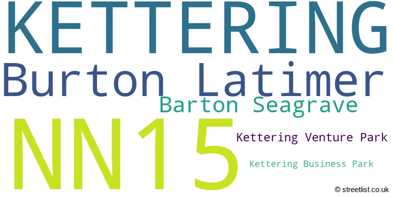
The largest settlement in the NN15 postal code is KETTERING followed by Burton Latimer, and Barton Seagrave.
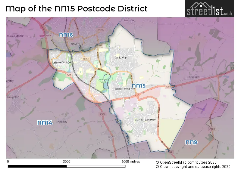
The NN15 Postcode shares a border with NN14 (Desborough, Rothwell, Thrapston), NN16 (KETTERING, Telford Way Industrial Estate) and NN9 (Raunds, Irthlingborough, Finedon).
The primary settlement in the NN15 postcode district is Kettering, located in the county of Northamptonshire in England. Other significant settlements in this district include Barton Seagrave and Burton Latimer. The most significant post town in this district is Kettering.
For the district NN15, we have data on 4 postcode sectors. Here's a breakdown: The sector NN15 4 is non-geographic. It's often designated for PO Boxes, large organisations, or special services. The sector NN15 5, covers Burton Latimer and Kettering and Barton Seagrave in Northamptonshire. The sector NN15 6, covers Kettering and Barton Seagrave in Northamptonshire. The sector NN15 7, covers Kettering in Northamptonshire.

Map of the NN15 Postcode District
Explore the NN15 postcode district by using our free interactive map.
When it comes to local government, postal geography often disregards political borders. However, for a breakdown in the NN15 District: the district mostly encompasses the North Northamptonshire area with a total of 935 postcodes.
Recent House Sales in NN15
| Date | Price | Address |
|---|---|---|
| 20/10/2023 | £415,000 | Hall Close, Kettering, NN15 7LQ |
| 17/10/2023 | £180,000 | Tresham Close, Kettering, NN15 7BX |
| 06/10/2023 | £240,000 | Robin Close, Barton Seagrave, Kettering, NN15 6SE |
| 06/10/2023 | £555,000 | Headlands, Kettering, NN15 6AD |
| 29/09/2023 | £225,000 | Willow Road, Kettering, NN15 7BB |
| 29/09/2023 | £140,000 | Highfield Road, Kettering, NN15 6HU |
| 22/09/2023 | £150,000 | Paradise Avenue, Kettering, NN15 6LU |
| 22/09/2023 | £225,000 | Garfield Street, Kettering, NN15 6BU |
| 15/09/2023 | £315,000 | Churchill Way, Kettering, NN15 5BZ |
| 14/09/2023 | £210,000 | Glastonbury Close, Kettering, NN15 5ES |
Weather Forecast for NN15
Press Button to Show Forecast for Wicksteed Park
| Time Period | Icon | Description | Temperature | Rain Probability | Wind |
|---|---|---|---|---|---|
| 06:00 to 09:00 | Cloudy | 5.0°C (feels like 3.0°C) | 11.00% | NE 9 mph | |
| 09:00 to 12:00 | Overcast | 7.0°C (feels like 5.0°C) | 16.00% | ENE 11 mph | |
| 12:00 to 15:00 | Overcast | 9.0°C (feels like 6.0°C) | 14.00% | ENE 11 mph | |
| 15:00 to 18:00 | Overcast | 9.0°C (feels like 6.0°C) | 14.00% | NE 13 mph | |
| 18:00 to 21:00 | Overcast | 8.0°C (feels like 5.0°C) | 13.00% | NE 13 mph | |
| 21:00 to 00:00 | Overcast | 7.0°C (feels like 4.0°C) | 42.00% | NE 11 mph |
Press Button to Show Forecast for Wicksteed Park
| Time Period | Icon | Description | Temperature | Rain Probability | Wind |
|---|---|---|---|---|---|
| 00:00 to 03:00 | Heavy rain | 7.0°C (feels like 3.0°C) | 80.00% | NNE 13 mph | |
| 03:00 to 06:00 | Heavy rain | 7.0°C (feels like 3.0°C) | 89.00% | NNE 13 mph | |
| 06:00 to 09:00 | Heavy rain | 7.0°C (feels like 3.0°C) | 91.00% | N 13 mph | |
| 09:00 to 12:00 | Heavy rain | 7.0°C (feels like 4.0°C) | 81.00% | NNW 11 mph | |
| 12:00 to 15:00 | Light rain | 8.0°C (feels like 5.0°C) | 54.00% | NW 11 mph | |
| 15:00 to 18:00 | Overcast | 9.0°C (feels like 7.0°C) | 19.00% | WNW 9 mph | |
| 18:00 to 21:00 | Cloudy | 10.0°C (feels like 8.0°C) | 9.00% | WSW 7 mph | |
| 21:00 to 00:00 | Clear night | 7.0°C (feels like 5.0°C) | 2.00% | SW 7 mph |
Press Button to Show Forecast for Wicksteed Park
| Time Period | Icon | Description | Temperature | Rain Probability | Wind |
|---|---|---|---|---|---|
| 00:00 to 03:00 | Clear night | 5.0°C (feels like 3.0°C) | 1.00% | SW 7 mph | |
| 03:00 to 06:00 | Clear night | 4.0°C (feels like 1.0°C) | 1.00% | SSW 7 mph | |
| 06:00 to 09:00 | Sunny day | 5.0°C (feels like 3.0°C) | 1.00% | S 7 mph | |
| 09:00 to 12:00 | Partly cloudy (day) | 11.0°C (feels like 9.0°C) | 1.00% | S 11 mph | |
| 12:00 to 15:00 | Cloudy | 13.0°C (feels like 11.0°C) | 5.00% | S 13 mph | |
| 15:00 to 18:00 | Partly cloudy (day) | 14.0°C (feels like 12.0°C) | 3.00% | S 13 mph | |
| 18:00 to 21:00 | Sunny day | 13.0°C (feels like 11.0°C) | 1.00% | S 9 mph | |
| 21:00 to 00:00 | Clear night | 9.0°C (feels like 7.0°C) | 1.00% | SSE 7 mph |
Press Button to Show Forecast for Wicksteed Park
| Time Period | Icon | Description | Temperature | Rain Probability | Wind |
|---|---|---|---|---|---|
| 00:00 to 03:00 | Clear night | 7.0°C (feels like 5.0°C) | 2.00% | SE 7 mph | |
| 03:00 to 06:00 | Clear night | 6.0°C (feels like 4.0°C) | 2.00% | ESE 7 mph | |
| 06:00 to 09:00 | Sunny day | 8.0°C (feels like 6.0°C) | 3.00% | ESE 7 mph | |
| 09:00 to 12:00 | Partly cloudy (day) | 13.0°C (feels like 11.0°C) | 3.00% | ESE 9 mph | |
| 12:00 to 15:00 | Cloudy | 16.0°C (feels like 13.0°C) | 9.00% | SE 11 mph | |
| 15:00 to 18:00 | Cloudy | 16.0°C (feels like 14.0°C) | 10.00% | ESE 11 mph | |
| 18:00 to 21:00 | Light rain shower (day) | 15.0°C (feels like 13.0°C) | 29.00% | ESE 9 mph | |
| 21:00 to 00:00 | Cloudy | 12.0°C (feels like 10.0°C) | 9.00% | E 7 mph |
Where is the NN15 Postcode District?
The postcode district NN15 is located in Kettering, a town in Northamptonshire. It is situated near several other towns including Wellingborough to the south (4.82 miles away), Corby to the north (7.56 miles away), Rushden to the southeast (8.07 miles away), Market Harborough to the northwest (11.46 miles away), Northampton to the southwest (12.61 miles away), and Stamford to the northeast (21.13 miles away). The district is approximately 64.90 miles away from the center of London.
The district is within the post town of KETTERING.
The sector has postcodes within the nation of England.
The NN15 Postcode District is in the North Northamptonshire region of Leicestershire, Rutland and Northamptonshire within the East Midlands (England).
| Postcode Sector | Delivery Office |
|---|---|
| NN15 5 | Kettering Delivery Office |
| NN15 6 | Kettering Delivery Office |
| NN15 7 | Kettering Delivery Office |
| N | N | 1 | 5 | - | X | X | X |
| N | N | 1 | 5 | Space | Numeric | Letter | Letter |
Current Monthly Rental Prices
| # Bedrooms | Min Price | Max Price | Avg Price |
|---|---|---|---|
| 1 | £400 | £850 | £614 |
| 2 | £795 | £900 | £853 |
| 3 | £995 | £1,250 | £1,142 |
| 4 | £1,100 | £2,200 | £1,500 |
| 6 | £4,500 | £4,500 | £4,500 |
Current House Prices
| # Bedrooms | Min Price | Max Price | Avg Price |
|---|---|---|---|
| 1 | £80,000 | £210,000 | £150,300 |
| 2 | £120,000 | £400,000 | £228,327 |
| 3 | £155,000 | £500,000 | £286,576 |
| 4 | £255,000 | £750,000 | £404,099 |
| 5 | £300,000 | £2,250,000 | £631,475 |
| 6 | £450,000 | £1,450,000 | £801,250 |
| 7 | £850,000 | £850,000 | £850,000 |
| 18 | £600,000 | £600,000 | £600,000 |
Estate Agents who Operate in the NN15 District
| Logo | Name | Brand Name | Address | Contact Number | Total Properties |
|---|---|---|---|---|---|
 | Kettering | Henderson Connellan | 15-16 Market Place, Kettering, NN16 0AJ | 01536 907610 | 51 |
 | Kettering | Simpson & Partners | 1 Silver Street, Kettering, NN16 0BN | 01536 907601 | 44 |
 | Kettering | Oscar James | 1 Newland Street, Kettering, NN16 8JH | 01536 907984 | 27 |
 | Kettering | Chris George The Estate Agent | 12B Horsemarket, Kettering, NN16 0DQ | 01536 907803 | 19 |
 | Kettering | Pattison Lane | 68-70 Gold Street Kettering Northamptonshire, NN16 8JB | 01536 907843 | 19 |
| Type of Property | 2018 Average | 2018 Sales | 2017 Average | 2017 Sales | 2016 Average | 2016 Sales | 2015 Average | 2015 Sales |
|---|---|---|---|---|---|---|---|---|
| Detached | £340,363 | 333 | £313,413 | 362 | £285,340 | 320 | £268,418 | 327 |
| Semi-Detached | £212,482 | 361 | £200,248 | 413 | £180,129 | 377 | £160,920 | 296 |
| Terraced | £188,541 | 143 | £168,222 | 182 | £156,390 | 185 | £147,143 | 178 |
| Flats | £132,164 | 44 | £120,123 | 47 | £108,974 | 46 | £125,153 | 61 |