The NN15 7 postcode sector is within the county of Northamptonshire.
Did you know? According to the 2021 Census, the NN15 7 postcode sector is home to a bustling 7,727 residents!
Given that each sector allows for 400 unique postcode combinations. Letters C, I, K, M, O and V are not allowed in the last two letters of a postcode. With 175 postcodes already in use, this leaves 225 units available.
The NN15 7 postal code covers the settlement of KETTERING.
The NN15 7 Postcode shares a border with NN15 5 (Burton Latimer, KETTERING, Barton Seagrave), NN15 6 (KETTERING, Barton Seagrave, Kettering Venture Park), NN16 0 (KETTERING), NN16 8 (KETTERING, Telford Way Industrial Estate) and NN14 1 (Broughton, Mawsley, Geddington).
The sector is within the post town of KETTERING.
NN15 7 is a postcode sector within the NN15 postcode district which is within the NN Northampton postcode area.
The Royal Mail delivery office for the NN15 7 postal sector is the Kettering Delivery Office.
The area of the NN15 7 postcode sector is 0.85 square miles which is 2.20 square kilometres or 544.42 square acres.
The NN15 7 postcode sector is crossed by the A14 Major A road.

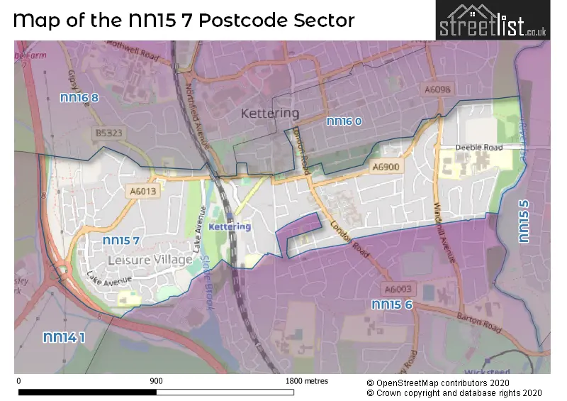
Map of the NN15 7 Postcode Sector
Explore the NN15 7 postcode sector by using our free interactive map.
| N | N | 1 | 5 | - | 7 | X | X |
| N | N | 1 | 5 | Space | 7 | Letter | Letter |
Official List of Streets
KETTERING (104 Streets)
Unofficial Streets or Alternative Spellings
KETTERING
BARNWELL STREET BOWHILL BROADWAY FIR ROAD GIPSY LANE GREEN LANE HERITAGE COURT MARKET STREET MERRIVALE CLOSE MILLDALE ROAD NEPCOTE CLOSE THURSTON DRIVE VALLEY WALK WALLIS ROAD WAVERLEY ROAD BEECH CRESCENT BROUGHTON INTERCHANGE CHURCH WALK FOXTON COURT GOADBYS YARD HOGS LANE HORSE MARKET LAKE AVENUE MOREHOUSE WAY SAINT MARYS ROAD WESTWAYWeather Forecast for NN15 7
Press Button to Show Forecast for Kettering
| Time Period | Icon | Description | Temperature | Rain Probability | Wind |
|---|---|---|---|---|---|
| 21:00 to 00:00 | Cloudy | 6.0°C (feels like 4.0°C) | 5.00% | ENE 9 mph |
Press Button to Show Forecast for Kettering
| Time Period | Icon | Description | Temperature | Rain Probability | Wind |
|---|---|---|---|---|---|
| 00:00 to 03:00 | Cloudy | 6.0°C (feels like 3.0°C) | 7.00% | ENE 7 mph | |
| 03:00 to 06:00 | Cloudy | 5.0°C (feels like 2.0°C) | 7.00% | NE 7 mph | |
| 06:00 to 09:00 | Cloudy | 5.0°C (feels like 3.0°C) | 11.00% | NE 7 mph | |
| 09:00 to 12:00 | Cloudy | 7.0°C (feels like 5.0°C) | 15.00% | ENE 11 mph | |
| 12:00 to 15:00 | Overcast | 9.0°C (feels like 6.0°C) | 15.00% | ENE 11 mph | |
| 15:00 to 18:00 | Overcast | 9.0°C (feels like 6.0°C) | 14.00% | NE 13 mph | |
| 18:00 to 21:00 | Overcast | 8.0°C (feels like 5.0°C) | 13.00% | NE 11 mph | |
| 21:00 to 00:00 | Overcast | 7.0°C (feels like 4.0°C) | 23.00% | NE 11 mph |
Press Button to Show Forecast for Kettering
| Time Period | Icon | Description | Temperature | Rain Probability | Wind |
|---|---|---|---|---|---|
| 00:00 to 03:00 | Light rain | 7.0°C (feels like 3.0°C) | 56.00% | NNE 13 mph | |
| 03:00 to 06:00 | Heavy rain | 6.0°C (feels like 3.0°C) | 89.00% | NNE 13 mph | |
| 06:00 to 09:00 | Heavy rain | 6.0°C (feels like 3.0°C) | 91.00% | N 13 mph | |
| 09:00 to 12:00 | Heavy rain | 7.0°C (feels like 3.0°C) | 87.00% | NNW 11 mph | |
| 12:00 to 15:00 | Light rain | 8.0°C (feels like 5.0°C) | 58.00% | NW 11 mph | |
| 15:00 to 18:00 | Overcast | 9.0°C (feels like 7.0°C) | 19.00% | WNW 9 mph | |
| 18:00 to 21:00 | Partly cloudy (day) | 9.0°C (feels like 8.0°C) | 6.00% | WSW 7 mph | |
| 21:00 to 00:00 | Clear night | 7.0°C (feels like 5.0°C) | 2.00% | SW 7 mph |
Press Button to Show Forecast for Kettering
| Time Period | Icon | Description | Temperature | Rain Probability | Wind |
|---|---|---|---|---|---|
| 00:00 to 03:00 | Clear night | 5.0°C (feels like 3.0°C) | 1.00% | SW 7 mph | |
| 03:00 to 06:00 | Clear night | 4.0°C (feels like 2.0°C) | 1.00% | SSW 7 mph | |
| 06:00 to 09:00 | Sunny day | 5.0°C (feels like 3.0°C) | 1.00% | S 7 mph | |
| 09:00 to 12:00 | Partly cloudy (day) | 11.0°C (feels like 9.0°C) | 1.00% | S 11 mph | |
| 12:00 to 15:00 | Cloudy | 13.0°C (feels like 11.0°C) | 6.00% | S 13 mph | |
| 15:00 to 18:00 | Partly cloudy (day) | 14.0°C (feels like 11.0°C) | 3.00% | S 11 mph | |
| 18:00 to 21:00 | Sunny day | 13.0°C (feels like 11.0°C) | 1.00% | S 9 mph | |
| 21:00 to 00:00 | Clear night | 8.0°C (feels like 6.0°C) | 1.00% | SSE 7 mph |
Press Button to Show Forecast for Kettering
| Time Period | Icon | Description | Temperature | Rain Probability | Wind |
|---|---|---|---|---|---|
| 00:00 to 03:00 | Clear night | 7.0°C (feels like 5.0°C) | 2.00% | SE 7 mph | |
| 03:00 to 06:00 | Clear night | 6.0°C (feels like 4.0°C) | 2.00% | ESE 7 mph | |
| 06:00 to 09:00 | Sunny day | 8.0°C (feels like 6.0°C) | 3.00% | ESE 7 mph | |
| 09:00 to 12:00 | Partly cloudy (day) | 12.0°C (feels like 11.0°C) | 3.00% | ESE 9 mph | |
| 12:00 to 15:00 | Cloudy | 15.0°C (feels like 13.0°C) | 8.00% | SE 11 mph | |
| 15:00 to 18:00 | Cloudy | 16.0°C (feels like 14.0°C) | 10.00% | ESE 11 mph | |
| 18:00 to 21:00 | Light rain shower (day) | 14.0°C (feels like 13.0°C) | 29.00% | ESE 9 mph | |
| 21:00 to 00:00 | Cloudy | 11.0°C (feels like 10.0°C) | 9.00% | E 7 mph |
Schools and Places of Education Within the NN15 7 Postcode Sector
Compass Primary Academy
Academy sponsor led
Windmill Avenue, Kettering, Northamptonshire, NN15 7EA
Head: Mrs Jo Fallowell
Ofsted Rating: Good
Inspection: 2023-04-26 (366 days ago)
Website: Visit Compass Primary Academy Website
Phone: 01536532707
Number of Pupils: 423
Hall Meadow Primary School
Academy converter
Packer Road, Kettering, Northamptonshire, NN15 7RP
Head: Mrs Cassandra Bodman-Knight
Ofsted Rating: Good
Inspection: 2022-12-07 (506 days ago)
Website: Visit Hall Meadow Primary School Website
Phone: 01536417627
Number of Pupils: 203
Hawthorn Community Primary School
Academy converter
Hawthorn Road, Kettering, Northamptonshire, NN15 7HT
Head: Mrs Emma Jacox
Ofsted Rating: Good
Inspection: 2023-09-13 (226 days ago)
Website: Visit Hawthorn Community Primary School Website
Phone: 01536512204
Number of Pupils: 294
Kettering Science Academy
Academy sponsor led
Deeble Road, Kettering, Northamptonshire, NN15 7AA
Head: Mrs Jennifer Giovanelli
Ofsted Rating: Good
Inspection: 2023-07-12 (289 days ago)
Website: Visit Kettering Science Academy Website
Phone: 01536532700
Number of Pupils: 1404
St Thomas More Catholic Primary School
Academy converter
St Thomas More Catholic Primary, Kettering, Northamptonshire, NN15 7JZ
Head: Mrs Sophie Howes
Ofsted Rating: Good
Inspection: 2023-06-28 (303 days ago)
Website: Visit St Thomas More Catholic Primary School Website
Phone: 01536512112
Number of Pupils: 216
Wren Spinney Community School
Academy special converter
Westover Road, Kettering, Northamptonshire, NN15 7LB
Head: Mr Joshua Gershwin-Williams
Ofsted Rating: Outstanding
Inspection: 2022-02-23 (793 days ago)
Website: Visit Wren Spinney Community School Website
Phone: 01536481939
Number of Pupils: 87
House Prices in the NN15 7 Postcode Sector
| Type of Property | 2018 Average | 2018 Sales | 2017 Average | 2017 Sales | 2016 Average | 2016 Sales | 2015 Average | 2015 Sales |
|---|---|---|---|---|---|---|---|---|
| Detached | £305,753 | 51 | £291,308 | 45 | £265,197 | 58 | £291,337 | 37 |
| Semi-Detached | £216,983 | 68 | £202,753 | 75 | £187,347 | 77 | £168,805 | 48 |
| Terraced | £203,820 | 35 | £179,205 | 49 | £164,167 | 41 | £143,146 | 27 |
| Flats | £140,729 | 21 | £121,638 | 35 | £119,718 | 26 | £140,644 | 40 |
Important Postcodes NN15 7 in the Postcode Sector
NN15 7AA is the postcode for Kettering Science Academy, Deeble Road
NN15 7EA is the postcode for The Compass Primary Academy, Windmill Avenue
NN15 7HH is the postcode for Clarendon House, 8-12 Station Road
NN15 7HP is the postcode for Headlands Surgery, 20 Headlands
NN15 7HT is the postcode for HAWTHORN PRIMARY SCHOOL, HAWTHORN ROAD
NN15 7JZ is the postcode for St. Thomas More Catholic Primary School, Northampton Road
NN15 7LB is the postcode for Wren Spinney School, Westover Road, and Wren Spinney Community Special School, Westover Road
NN15 7NX is the postcode for Linden Medical Centre, 54 Linden Avenue
NN15 7PQ is the postcode for Youth Offending Team, 73 London Road, and London Road C E C, 75a London Road
NN15 7PW is the postcode for CAREY BLOCK, Northamptonshire Health Care Trust, St. Marys Hospital, 77 London Road, Welland Centre, Northamptonshire Health Care Trust, St. Marys Hospital, JOHN NOTLEY UNIT, Northamptonshire Health Care Trust, St. Marys Hospital, 77 London Road, MAIN / ENTRANCE BLOCK - BLOCKS 1, 2, 4, 5, 6, 20 & 28, Northamptonshire Health Care Trust, St. Marys Hospital, 77 London Road, DRYLAND BLOCK, Northamptonshire Health Care Trust, St. Marys Hospital, 77 London Road, THE FOREST CENTRE, Northamptonshire Health Care Trust, St. Marys Hospital, 77 London Road, SUDBROUGH HOUSE, Northamptonshire Health Care Trust, St. Marys Hospital, 77 London Road, WARD BLOCK - BLOCKS 16, 17, 24 & 26, Northamptonshire Health Care Trust, St. Marys Hospital, 77 London Road, Northamptonshire Healthcare NHS Trust, St. Mary's Hospital (rp1), OAKWOOD CENTRE, Northamptonshire Health Care Trust, St. Marys Hospital, 77 London Road, WELLAND CENTRE, Northamptonshire Health Care Trust, St. Marys Hospital, 77 London Road, and HUXLOW HOUSE, Northamptonshire Health Care Trust, St. Marys Hospital, 77 London Road
NN15 7QA is the postcode for Kettering Swimming Pool, London Road, and Drovers Hall, 40 London Road, Kettering
NN15 7QP is the postcode for Northamptonshire Police, Police Station, London Road, KETTERING POLICE STATION, Northamptonshire Police, Police Station, London Road, and Kettering Magistrates' Court, The Court House
NN15 7QX is the postcode for Kettering Borough Council, Council Offices, Bowling Green Road, MAIN BUILDING, Kettering Borough Council, Council Offices, Bowling Green Road, and MAIN BUILDING, North Northamptonshire Council, Bowling Green Road
NN15 7RP is the postcode for Hall Meadow Primary School, Packer Road
| The NN15 7 Sector is within these Local Authorities |
|
|---|---|
| The NN15 7 Sector is within these Counties |
|
| The NN15 7 Sector is within these Water Company Areas |
|