The NN9 5 postcode sector is within the county of Northamptonshire.
Did you know? According to the 2021 Census, the NN9 5 postcode sector is home to a bustling 15,988 residents!
Given that each sector allows for 400 unique postcode combinations. Letters C, I, K, M, O and V are not allowed in the last two letters of a postcode. With 344 postcodes already in use, this leaves 56 units available.
The largest settlement in the NN9 5 postal code is Irthlingborough followed by Finedon, and WELLINGBOROUGH.
The NN9 5 Postcode shares a border with NN15 5 (Burton Latimer, KETTERING, Barton Seagrave), NN6 0 (Earls Barton, Overstone, Sywell), NN8 1 (WELLINGBOROUGH), NN8 4 (WELLINGBOROUGH, Finedon Road Industrial Estate), NN8 5 (WELLINGBOROUGH), NN8 6 (WELLINGBOROUGH, Park Farm Industrial Estate), NN10 8 (Higham Ferrers), NN14 4 (Thrapston, Ringstead, Woodford), NN2 8 (NORTHAMPTON, Boughton), NN6 9 (Brixworth, Walgrave, Pitsford), NN9 6 (Raunds, Stanwick, Hargrave) and NN14 1 (Broughton, Mawsley, Geddington).
The sector is within the post town of WELLINGBOROUGH.
NN9 5 is a postcode sector within the NN9 postcode district which is within the NN Northampton postcode area.
The Royal Mail delivery office for the NN9 5 postal sector is the Finedelivery Officen Scale Payment Delivery Office and Wellingborough Delivery Office.
The area of the NN9 5 postcode sector is 16.02 square miles which is 41.48 square kilometres or 10,249.70 square acres.
The NN9 5 postcode sector is crossed by the A45 Major A road.
Waterways within the NN9 5 postcode sector include the River Nene.

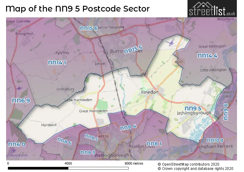
Map of the NN9 5 Postcode Sector
Explore the NN9 5 postcode sector by using our free interactive map.
| N | N | 9 | - | 5 | X | X |
| N | N | 9 | Space | 5 | Letter | Letter |
Official List of Streets
Irthlingborough (146 Streets)
Finedon (77 Streets)
Little Harrowden (24 Streets)
WELLINGBOROUGH (14 Streets)
Hardwick (3 Streets)
Great Harrowden (5 Streets)
Unofficial Streets or Alternative Spellings
Finedon
ALEXANDER CLOSE ALLEN COURT ORCHARD CLOSE ST. MARYS AVENUEBurton Latimer
FINEDON ROAD WOLD ROADIsham
WELLINGBOROUGH ROADWELLINGBOROUGH
GLENVALE DRIVE NIORT WAYWeather Forecast for NN9 5
Press Button to Show Forecast for Burton Latimer
| Time Period | Icon | Description | Temperature | Rain Probability | Wind |
|---|---|---|---|---|---|
| 09:00 to 12:00 | Sunny day | 7.0°C (feels like 5.0°C) | 2.00% | ENE 7 mph | |
| 12:00 to 15:00 | Overcast | 10.0°C (feels like 9.0°C) | 9.00% | ENE 4 mph | |
| 15:00 to 18:00 | Cloudy | 10.0°C (feels like 9.0°C) | 8.00% | ENE 4 mph | |
| 18:00 to 21:00 | Cloudy | 8.0°C (feels like 6.0°C) | 8.00% | ENE 9 mph | |
| 21:00 to 00:00 | Cloudy | 5.0°C (feels like 3.0°C) | 9.00% | ENE 7 mph |
Press Button to Show Forecast for Burton Latimer
| Time Period | Icon | Description | Temperature | Rain Probability | Wind |
|---|---|---|---|---|---|
| 00:00 to 03:00 | Partly cloudy (night) | 4.0°C (feels like 2.0°C) | 7.00% | ENE 4 mph | |
| 03:00 to 06:00 | Cloudy | 3.0°C (feels like 1.0°C) | 11.00% | ENE 7 mph | |
| 06:00 to 09:00 | Cloudy | 4.0°C (feels like 1.0°C) | 15.00% | NE 7 mph | |
| 09:00 to 12:00 | Cloudy | 8.0°C (feels like 5.0°C) | 16.00% | ENE 9 mph | |
| 12:00 to 15:00 | Overcast | 10.0°C (feels like 8.0°C) | 22.00% | ENE 11 mph | |
| 15:00 to 18:00 | Overcast | 11.0°C (feels like 9.0°C) | 21.00% | ENE 11 mph | |
| 18:00 to 21:00 | Cloudy | 9.0°C (feels like 7.0°C) | 19.00% | NE 11 mph | |
| 21:00 to 00:00 | Light rain | 7.0°C (feels like 4.0°C) | 53.00% | NE 11 mph |
Press Button to Show Forecast for Burton Latimer
| Time Period | Icon | Description | Temperature | Rain Probability | Wind |
|---|---|---|---|---|---|
| 00:00 to 03:00 | Light rain | 7.0°C (feels like 4.0°C) | 49.00% | NE 11 mph | |
| 03:00 to 06:00 | Heavy rain | 7.0°C (feels like 4.0°C) | 77.00% | NE 11 mph | |
| 06:00 to 09:00 | Heavy rain | 8.0°C (feels like 6.0°C) | 77.00% | E 9 mph | |
| 09:00 to 12:00 | Light rain | 10.0°C (feels like 8.0°C) | 51.00% | SE 9 mph | |
| 12:00 to 15:00 | Light rain | 12.0°C (feels like 10.0°C) | 56.00% | SSE 9 mph | |
| 15:00 to 18:00 | Light rain shower (day) | 12.0°C (feels like 9.0°C) | 41.00% | SW 11 mph | |
| 18:00 to 21:00 | Light rain shower (day) | 10.0°C (feels like 8.0°C) | 35.00% | NE 11 mph | |
| 21:00 to 00:00 | Cloudy | 8.0°C (feels like 6.0°C) | 10.00% | SSW 7 mph |
Schools and Places of Education Within the NN9 5 Postcode Sector
Finedon Infant School
Academy converter
Orchard Road, Wellingborough, Northamptonshire, NN9 5JG
Head: Mrs Joanne Lloyd-Williams
Ofsted Rating: Good
Inspection: 2023-10-19 (190 days ago)
Website: Visit Finedon Infant School Website
Phone: 01933680467
Number of Pupils: 135
Finedon Mulso Church of England Junior School
Academy converter
Wellingborough Road, Wellingborough, Northamptonshire, NN9 5JT
Head: Mrs Joanne Lloyd-Williams
Ofsted Rating: Good
Inspection: 2023-03-14 (409 days ago)
Website: Visit Finedon Mulso Church of England Junior School Website
Phone: 01933680433
Number of Pupils: 178
Irthlingborough Junior School
Academy converter
College Street, Wellingborough, Northamptonshire, NN9 5TX
Head: Mr Nicholas Garley
Ofsted Rating: Good
Inspection: 2020-01-15 (1563 days ago)
Website: Visit Irthlingborough Junior School Website
Phone: 01933654921
Number of Pupils: 381
Irthlingborough Nursery and Infant School
Academy converter
Scarborough Street, Wellingborough, Northamptonshire, NN9 5TT
Head: Mrs Jan Marshall
Ofsted Rating: Good
Inspection: 2023-07-13 (288 days ago)
Website: Visit Irthlingborough Nursery and Infant School Website
Phone: 01933654900
Number of Pupils: 325
Little Harrowden Community Primary School
Academy converter
School Lane, Wellingborough, Northamptonshire, NN9 5BN
Head: Miss Beth Renshaw
Ofsted Rating: Good
Inspection: 2023-01-18 (464 days ago)
Website: Visit Little Harrowden Community Primary School Website
Phone: 01933677202
Number of Pupils: 188
House Prices in the NN9 5 Postcode Sector
| Type of Property | 2018 Average | 2018 Sales | 2017 Average | 2017 Sales | 2016 Average | 2016 Sales | 2015 Average | 2015 Sales |
|---|---|---|---|---|---|---|---|---|
| Detached | £330,387 | 69 | £321,956 | 82 | £265,306 | 80 | £261,100 | 85 |
| Semi-Detached | £197,928 | 96 | £194,580 | 118 | £175,927 | 96 | £150,249 | 91 |
| Terraced | £177,977 | 91 | £167,839 | 118 | £151,217 | 101 | £133,564 | 110 |
| Flats | £95,357 | 21 | £93,686 | 33 | £92,503 | 38 | £81,333 | 15 |
Important Postcodes NN9 5 in the Postcode Sector
NN9 5BN is the postcode for Little Harrowden Primary School, School Lane
NN9 5GF is the postcode for Kettering General Hospital Nene Park, Attley Way
NN9 5JG is the postcode for Finedon Infant School, Orchard Road, and BLOCK B, Finedon Infant School, Orchard Road
NN9 5JT is the postcode for Finedon Mulso C of E Junior School, Wellingborough Road, and Finedon Mulso C E Junior School, Wellingborough Road
NN9 5PU is the postcode for Northamptonshire County Council, Irthlingborough Library, High Street
NN9 5TT is the postcode for Irthlingborough Nursery & Infant School, Scarborough Street, and MAIN BUILDING - INFANT SCHOOL, Irthlingborough Nursery & Infant School, Scarborough Street
NN9 5TX is the postcode for Irthlingborough Junior School, College Street, and Irthlingborough Junior School, College Street, Irthlingborough
NN9 5TY is the postcode for Huxlow Academy A0+C0 Main and Drama Building, Finedon Road, Irthlingborough, Huxlow Academy - D0 Admin Building, Finedon Road, Ithlingbourough, D0 - ADMIN/ENGLISH/MFL, Huxlow Science College, Finedon Road, Huxlow Academy - L0 Sports Building, Finedon Road, Irthlingborough, B0 - HUMANITIES/MATHS/ESD, Huxlow Science College, Finedon Road, Huxlow Academy - B0 Maths, Finedon Road, Irthlingborough, Huxlow Academy - N0 Sixth Form, Finedon Road, Irthlingborough, A0 - MAIN BLOCK, Huxlow Science College, Finedon Road, and Huxlow Science College, Finedon Road
| The NN9 5 Sector is within these Local Authorities |
|
|---|---|
| The NN9 5 Sector is within these Counties |
|
| The NN9 5 Sector is within these Water Company Areas |
|