The NN14 4 postcode sector stands on the Cambridgeshire and Northamptonshire border.
Did you know? According to the 2021 Census, the NN14 4 postcode sector is home to a bustling 11,535 residents!
Given that each sector allows for 400 unique postcode combinations. Letters C, I, K, M, O and V are not allowed in the last two letters of a postcode. With 302 postcodes already in use, this leaves 98 units available.
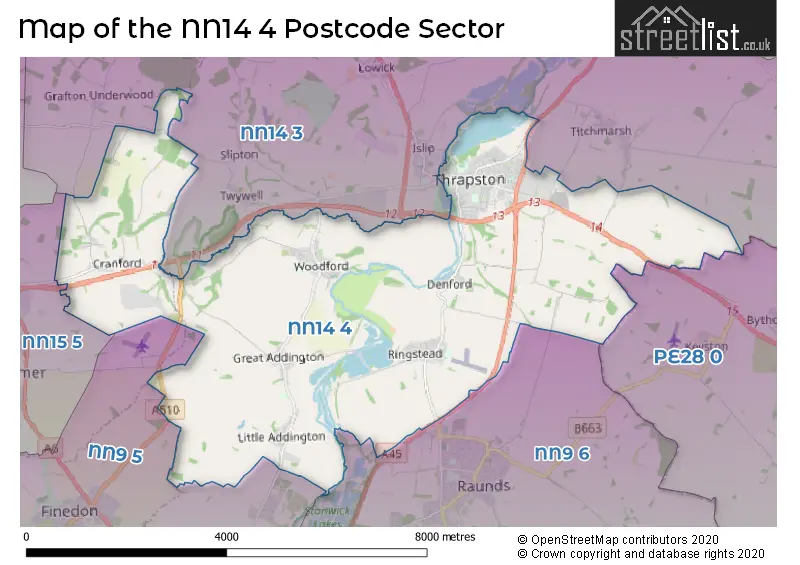
The largest settlement in the NN14 4 postal code is Thrapston followed by Ringstead, and Woodford.
The NN14 4 Postcode shares a border with NN15 5 (Burton Latimer, KETTERING, Barton Seagrave), PE28 0 (Kimbolton, Perry, Ellington), NN14 3 (Brigstock, Islip, Titchmarsh), NN9 5 (Irthlingborough, Finedon, WELLINGBOROUGH) and NN9 6 (Raunds, Stanwick, Hargrave).
The sector is within the post town of KETTERING.
NN14 4 is a postcode sector within the NN14 postcode district which is within the NN Northampton postcode area.
The Royal Mail delivery office for the NN14 4 postal sector is the Kettering Delivery Office.
The area of the NN14 4 postcode sector is 19.46 square miles which is 50.41 square kilometres or 12,457.15 square acres.
The NN14 4 postcode sector is crossed by the A14 Major A road.
The NN14 4 postcode sector is crossed by the A45 Major A road.
Waterways within the NN14 4 postcode sector include the River Nene.

Map of the NN14 4 Postcode Sector
Explore the NN14 4 postcode sector by using our free interactive map.
| N | N | 1 | 4 | - | 4 | X | X |
| N | N | 1 | 4 | Space | 4 | Letter | Letter |
Official List of Streets
Thrapston (140 Streets)
Woodford (31 Streets)
Little Addington (13 Streets)
Ringstead (34 Streets)
Cranford (12 Streets)
Denford (15 Streets)
Great Addington (9 Streets)
Islip (1 Streets)
Unofficial Streets or Alternative Spellings
Titchmarsh
ISLINGTONBythorn
THRAPSTON ROADRaunds
BROOKS ROADIrthlingborough
ADDINGTON ROADIslip
KETTERING ROADBarton Seagrave
CRANFORD ROADFinedon
THRAPSTON ROADWeather Forecast for NN14 4
Press Button to Show Forecast for Denford
| Time Period | Icon | Description | Temperature | Rain Probability | Wind |
|---|---|---|---|---|---|
| 12:00 to 15:00 | Cloudy | 19.0°C (feels like 15.0°C) | 3.00% | S 18 mph | |
| 15:00 to 18:00 | Cloudy | 20.0°C (feels like 15.0°C) | 4.00% | S 16 mph | |
| 18:00 to 21:00 | Cloudy | 18.0°C (feels like 15.0°C) | 5.00% | S 13 mph | |
| 21:00 to 00:00 | Cloudy | 16.0°C (feels like 14.0°C) | 10.00% | SE 9 mph |
Press Button to Show Forecast for Denford
| Time Period | Icon | Description | Temperature | Rain Probability | Wind |
|---|---|---|---|---|---|
| 00:00 to 03:00 | Cloudy | 15.0°C (feels like 13.0°C) | 61.00% | ESE 9 mph | |
| 03:00 to 06:00 | Light rain | 15.0°C (feels like 13.0°C) | 68.00% | SE 9 mph | |
| 06:00 to 09:00 | Heavy rain | 14.0°C (feels like 13.0°C) | 91.00% | SE 9 mph | |
| 09:00 to 12:00 | Heavy rain | 14.0°C (feels like 13.0°C) | 91.00% | SSE 9 mph | |
| 12:00 to 15:00 | Light rain | 15.0°C (feels like 13.0°C) | 58.00% | SSE 11 mph | |
| 15:00 to 18:00 | Light rain | 15.0°C (feels like 13.0°C) | 49.00% | SSE 11 mph | |
| 18:00 to 21:00 | Cloudy | 15.0°C (feels like 13.0°C) | 11.00% | SE 11 mph | |
| 21:00 to 00:00 | Cloudy | 13.0°C (feels like 12.0°C) | 7.00% | SE 9 mph |
Press Button to Show Forecast for Denford
| Time Period | Icon | Description | Temperature | Rain Probability | Wind |
|---|---|---|---|---|---|
| 00:00 to 03:00 | Cloudy | 13.0°C (feels like 11.0°C) | 7.00% | SE 9 mph | |
| 03:00 to 06:00 | Cloudy | 12.0°C (feels like 11.0°C) | 8.00% | ESE 7 mph | |
| 06:00 to 09:00 | Cloudy | 13.0°C (feels like 11.0°C) | 14.00% | ESE 7 mph | |
| 09:00 to 12:00 | Cloudy | 15.0°C (feels like 14.0°C) | 17.00% | SE 7 mph | |
| 12:00 to 15:00 | Cloudy | 18.0°C (feels like 16.0°C) | 14.00% | SE 9 mph | |
| 15:00 to 18:00 | Light rain shower (day) | 18.0°C (feels like 17.0°C) | 31.00% | SE 7 mph | |
| 18:00 to 21:00 | Light rain shower (day) | 17.0°C (feels like 16.0°C) | 29.00% | ESE 7 mph | |
| 21:00 to 00:00 | Clear night | 13.0°C (feels like 12.0°C) | 2.00% | SE 4 mph |
Press Button to Show Forecast for Denford
| Time Period | Icon | Description | Temperature | Rain Probability | Wind |
|---|---|---|---|---|---|
| 00:00 to 03:00 | Clear night | 10.0°C (feels like 9.0°C) | 3.00% | SE 4 mph | |
| 03:00 to 06:00 | Fog | 9.0°C (feels like 8.0°C) | 15.00% | ESE 4 mph | |
| 06:00 to 09:00 | Fog | 11.0°C (feels like 11.0°C) | 16.00% | NE 2 mph | |
| 09:00 to 12:00 | Cloudy | 16.0°C (feels like 16.0°C) | 7.00% | E 4 mph | |
| 12:00 to 15:00 | Cloudy | 18.0°C (feels like 17.0°C) | 15.00% | SW 4 mph | |
| 15:00 to 18:00 | Light rain | 17.0°C (feels like 17.0°C) | 47.00% | SSW 7 mph | |
| 18:00 to 21:00 | Cloudy | 16.0°C (feels like 16.0°C) | 13.00% | W 7 mph | |
| 21:00 to 00:00 | Cloudy | 13.0°C (feels like 13.0°C) | 9.00% | SSW 4 mph |
Press Button to Show Forecast for Denford
| Time Period | Icon | Description | Temperature | Rain Probability | Wind |
|---|---|---|---|---|---|
| 00:00 to 03:00 | Partly cloudy (night) | 12.0°C (feels like 11.0°C) | 4.00% | WNW 4 mph | |
| 03:00 to 06:00 | Mist | 11.0°C (feels like 10.0°C) | 15.00% | WNW 4 mph | |
| 06:00 to 09:00 | Overcast | 12.0°C (feels like 11.0°C) | 11.00% | WNW 4 mph | |
| 09:00 to 12:00 | Overcast | 16.0°C (feels like 15.0°C) | 12.00% | NW 7 mph | |
| 12:00 to 15:00 | Light rain shower (day) | 18.0°C (feels like 17.0°C) | 33.00% | NW 7 mph | |
| 15:00 to 18:00 | Light rain shower (day) | 19.0°C (feels like 18.0°C) | 38.00% | NNW 7 mph | |
| 18:00 to 21:00 | Cloudy | 17.0°C (feels like 16.0°C) | 13.00% | NW 7 mph | |
| 21:00 to 00:00 | Cloudy | 14.0°C (feels like 13.0°C) | 8.00% | NNW 7 mph |
Schools and Places of Education Within the NN14 4 Postcode Sector
Cranford CofE Primary School
Academy converter
Church Lane, Kettering, , NN14 4AE
Head: Mr Robert Tyman
Ofsted Rating: Outstanding
Inspection: 2021-10-06 (950 days ago)
Website: Visit Cranford CofE Primary School Website
Phone: 01536330300
Number of Pupils: 100
Great Addington CofE Primary School
Academy converter
Woodford Road, Kettering, Northamptonshire, NN14 4BS
Head: Mrs Lucy Kingsnorth
Ofsted Rating: Good
Inspection: 2023-03-09 (431 days ago)
Website: Visit Great Addington CofE Primary School Website
Phone: 01536330642
Number of Pupils: 87
Progress Schools - Thrapston
Other independent school
Cedar Drive, , , NN14 4LZ
Head: Miss Rachel Parmanum
Ofsted Rating: Inadequate
Inspection: 2022-03-17 (788 days ago)
Website: Visit Progress Schools - Thrapston Website
Phone: 01832777089
Number of Pupils: 24
Ringstead Church of England Primary School
Academy converter
Church Street, Kettering, Northamptonshire, NN14 4DH
Head: Mrs Helen Roberts
Ofsted Rating: Good
Inspection: 2018-01-18 (2307 days ago)
Website: Visit Ringstead Church of England Primary School Website
Phone: 01933622734
Number of Pupils: 130
Woodford Church of England Primary School
Academy converter
High Street, Kettering, Northamptonshire, NN14 4HF
Head: Mr Lee Donovan
Ofsted Rating: Good
Inspection: 2023-05-11 (368 days ago)
Website: Visit Woodford Church of England Primary School Website
Phone: 01832733221
Number of Pupils: 109
House Prices in the NN14 4 Postcode Sector
| Type of Property | 2018 Average | 2018 Sales | 2017 Average | 2017 Sales | 2016 Average | 2016 Sales | 2015 Average | 2015 Sales |
|---|---|---|---|---|---|---|---|---|
| Detached | £350,501 | 89 | £314,780 | 112 | £307,676 | 91 | £302,405 | 66 |
| Semi-Detached | £211,546 | 62 | £202,485 | 65 | £186,845 | 60 | £183,467 | 52 |
| Terraced | £198,118 | 54 | £172,307 | 66 | £170,168 | 87 | £154,338 | 52 |
| Flats | £177,415 | 6 | £162,203 | 19 | £145,081 | 23 | £91,950 | 4 |
Important Postcodes NN14 4 in the Postcode Sector
NN14 4DH is the postcode for Ringstead C of E Primary School, Church Street
NN14 4HF is the postcode for Woodford C of E Primary School, High Street
NN14 4JJ is the postcode for Thrapston Library, 15 High Street, Thrapston
NN14 4JL is the postcode for Green Lane Health Clinic, Chancery Lane
NN14 4JU is the postcode for The King John School, Market Road, Thrapston Primary School, Market Street, RED KITE, Thrapston Cp School, Market Road, BLOCK T1, The King John School, Market Road, THE CROWN BUILDING, The King John School, Market Road, THE CROWN, Thrapston Cp School, Market Road, and RECEPTION BLOCK B, Thrapston Primary School, Market Street
NN14 4JY is the postcode for The Nene Centre, Cedar Drive, Thrapston, and The Nene Centre, Cedar Drive
NN14 4LZ is the postcode for North Northamptonshire Council, East Northamptonshire House, Cedar Drive, Thrapston, East Northamptionshire Council, East Northamptonshire Council, East Northamptonshire House, Cedar Drive, and East Northamptonshire Council, East Northamptonshire House, Cedar Drive
| The NN14 4 Sector is within these Local Authorities |
|
|---|---|
| The NN14 4 Sector is within these Counties |
|
| The NN14 4 Sector is within these Water Company Areas |
|