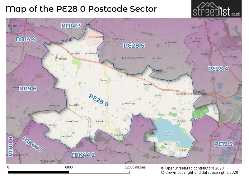
The PE28 0 postcode sector lies where the three counties of Bedfordshire, Cambridgeshire, and Northamptonshire meet.
Did you know? According to the 2021 Census, the PE28 0 postcode sector is home to a bustling 6,606 residents!
Given that each sector allows for 400 unique postcode combinations. Letters C, I, K, M, O and V are not allowed in the last two letters of a postcode. With 238 postcodes already in use, this leaves 162 units available.
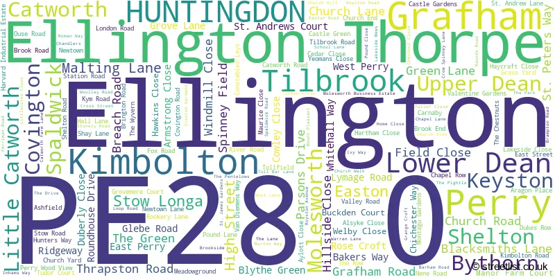
The largest settlement in the PE28 0 postal code is Kimbolton followed by Perry, and Ellington.
The PE28 0 Postcode shares a border with MK44 1 (Sharnbrook, Riseley, Milton Ernest), MK44 2 (Thurleigh, Keysoe, Ravensden), PE19 5 (Buckden, Great Staughton, Offord D'Arcy), PE28 4 (Brampton, Alconbury, Alconbury Weald), PE28 5 (Sawtry, Glatton, Woodwalton), NN14 3 (Brigstock, Islip, Titchmarsh), NN14 4 (Thrapston, Ringstead, Woodford) and NN9 6 (Raunds, Stanwick, Hargrave).
The sector is within the post town of HUNTINGDON.
PE28 0 is a postcode sector within the PE28 postcode district which is within the PE Peterborough postcode area.
The Royal Mail delivery office for the PE28 0 postal sector is the Huntingdon Delivery Office and Kimbolton Scale Payment Delivery Office.
The area of the PE28 0 postcode sector is 44.76 square miles which is 115.92 square kilometres or 28,643.36 square acres.
The PE28 0 postcode sector is crossed by the A14 Major A road.
The PE28 0 postcode sector is crossed by the A1 Major A road.

Map of the PE28 0 Postcode Sector
Explore the PE28 0 postcode sector by using our free interactive map.
| P | E | 2 | 8 | - | 0 | X | X |
| P | E | 2 | 8 | Space | 0 | Letter | Letter |
Official List of Streets
Grafham (17 Streets)
Kimbolton (36 Streets)
Perry (25 Streets)
Upper Dean (7 Streets)
Spaldwick (16 Streets)
Ellington (14 Streets)
Catworth (11 Streets)
Molesworth (2 Streets)
Tilbrook (6 Streets)
Easton (7 Streets)
Bythorn (4 Streets)
Covington (4 Streets)
Stow Longa (5 Streets)
Keyston (6 Streets)
HUNTINGDON (1 Streets)
Ellington Thorpe (1 Streets)
Lower Dean (2 Streets)
Unofficial Streets or Alternative Spellings
Brampton
BUCKDEN ROAD THRAPSTON ROADBuckden
GREAT NORTH ROAD PERRY ROAD BELTONS HILL BIGHAMS LANE BLACKSMITHS BRINGTON GORSE BROADWEIR BROOK LANE BUCKDEN ROAD BUSTARD HILL CHAINBRIDGE LANE CHATWORTH FARM LANE CLACK LANE COCKWAY LANE CROMWELL COURT CROSS RIDE DUCHESS WALK GROVE ROAD HARTHAM STREET HARVARD WAY HUNTINGDON ROAD KIM ROAD MAIN RIDE MAIN STREET MANDER CAR PARK MANOR FARM MERE LANE (BYWAY) MICKLE HILL NEWTOWN (THE CHESTNUTS) OLD THRAPSTON ROAD SAINT PETERS WAY SANDY LANE SMITHS LANE ST ANDREWS LANE STOCKING LANE THE PENTELOWES THORNBERRY THREE SHIRES WAY VAN DIEMANS WAY WEST RIDE WESTWOOD LODGE WOOLLEY HILLOld Weston
COCKBROOK LANEStonely
HATCHET LANE PARK LANESwineshead
SANDYE LANEHargrave
CHURCH ROADWeather Forecast for PE28 0
Press Button to Show Forecast for Raunds
| Time Period | Icon | Description | Temperature | Rain Probability | Wind |
|---|---|---|---|---|---|
| 18:00 to 21:00 | Overcast | 8.0°C (feels like 4.0°C) | 22.00% | NE 13 mph | |
| 21:00 to 00:00 | Heavy rain | 7.0°C (feels like 4.0°C) | 87.00% | NE 13 mph |
Press Button to Show Forecast for Raunds
| Time Period | Icon | Description | Temperature | Rain Probability | Wind |
|---|---|---|---|---|---|
| 00:00 to 03:00 | Heavy rain | 7.0°C (feels like 4.0°C) | 95.00% | NNE 13 mph | |
| 03:00 to 06:00 | Heavy rain | 7.0°C (feels like 4.0°C) | 96.00% | NNE 16 mph | |
| 06:00 to 09:00 | Heavy rain | 7.0°C (feels like 5.0°C) | 93.00% | N 11 mph | |
| 09:00 to 12:00 | Light rain | 8.0°C (feels like 5.0°C) | 58.00% | WNW 11 mph | |
| 12:00 to 15:00 | Overcast | 7.0°C (feels like 3.0°C) | 49.00% | WNW 16 mph | |
| 15:00 to 18:00 | Cloudy | 9.0°C (feels like 6.0°C) | 49.00% | W 13 mph | |
| 18:00 to 21:00 | Cloudy | 9.0°C (feels like 7.0°C) | 6.00% | SW 9 mph | |
| 21:00 to 00:00 | Partly cloudy (night) | 7.0°C (feels like 4.0°C) | 0.00% | SSW 7 mph |
Press Button to Show Forecast for Raunds
| Time Period | Icon | Description | Temperature | Rain Probability | Wind |
|---|---|---|---|---|---|
| 00:00 to 03:00 | Clear night | 5.0°C (feels like 2.0°C) | 0.00% | SW 9 mph | |
| 03:00 to 06:00 | Clear night | 4.0°C (feels like 1.0°C) | 0.00% | SSW 7 mph | |
| 06:00 to 09:00 | Sunny day | 6.0°C (feels like 3.0°C) | 0.00% | S 9 mph | |
| 09:00 to 12:00 | Partly cloudy (day) | 11.0°C (feels like 9.0°C) | 1.00% | SSW 13 mph | |
| 12:00 to 15:00 | Cloudy | 14.0°C (feels like 11.0°C) | 7.00% | S 16 mph | |
| 15:00 to 18:00 | Cloudy | 15.0°C (feels like 12.0°C) | 4.00% | S 16 mph | |
| 18:00 to 21:00 | Sunny day | 13.0°C (feels like 11.0°C) | 1.00% | S 11 mph | |
| 21:00 to 00:00 | Clear night | 9.0°C (feels like 7.0°C) | 0.00% | SSE 9 mph |
Press Button to Show Forecast for Raunds
| Time Period | Icon | Description | Temperature | Rain Probability | Wind |
|---|---|---|---|---|---|
| 00:00 to 03:00 | Clear night | 7.0°C (feels like 5.0°C) | 0.00% | SE 9 mph | |
| 03:00 to 06:00 | Clear night | 7.0°C (feels like 5.0°C) | 0.00% | SE 7 mph | |
| 06:00 to 09:00 | Partly cloudy (day) | 8.0°C (feels like 6.0°C) | 1.00% | ESE 7 mph | |
| 09:00 to 12:00 | Partly cloudy (day) | 13.0°C (feels like 11.0°C) | 12.00% | SE 9 mph | |
| 12:00 to 15:00 | Cloudy | 16.0°C (feels like 13.0°C) | 18.00% | SE 11 mph | |
| 15:00 to 18:00 | Light rain shower (day) | 16.0°C (feels like 14.0°C) | 30.00% | SE 11 mph | |
| 18:00 to 21:00 | Cloudy | 15.0°C (feels like 13.0°C) | 10.00% | SE 9 mph | |
| 21:00 to 00:00 | Cloudy | 12.0°C (feels like 11.0°C) | 9.00% | ESE 7 mph |
Press Button to Show Forecast for Raunds
| Time Period | Icon | Description | Temperature | Rain Probability | Wind |
|---|---|---|---|---|---|
| 00:00 to 03:00 | Cloudy | 11.0°C (feels like 10.0°C) | 12.00% | ESE 4 mph | |
| 03:00 to 06:00 | Cloudy | 10.0°C (feels like 9.0°C) | 11.00% | E 4 mph | |
| 06:00 to 09:00 | Mist | 11.0°C (feels like 10.0°C) | 18.00% | ENE 4 mph | |
| 09:00 to 12:00 | Cloudy | 14.0°C (feels like 13.0°C) | 10.00% | E 4 mph | |
| 12:00 to 15:00 | Partly cloudy (day) | 17.0°C (feels like 16.0°C) | 10.00% | E 7 mph | |
| 15:00 to 18:00 | Cloudy | 18.0°C (feels like 16.0°C) | 11.00% | ENE 9 mph | |
| 18:00 to 21:00 | Cloudy | 15.0°C (feels like 14.0°C) | 10.00% | ESE 9 mph | |
| 21:00 to 00:00 | Cloudy | 11.0°C (feels like 10.0°C) | 9.00% | E 9 mph |
Schools and Places of Education Within the PE28 0 Postcode Sector
Eileen Wade Primary School
Foundation school
High Street, Huntingdon, Cambridgeshire, PE28 0ND
Head: Mrs Lisa Virnuls
Ofsted Rating: Good
Inspection: 2021-06-11 (1051 days ago)
Website: Visit Eileen Wade Primary School Website
Phone: 01234708260
Number of Pupils: 80
Kimbolton Primary Academy
Academy sponsor led
Newtown, Huntingdon, Cambridgeshire, PE28 0HY
Head: Mrs Suzanne Whiting
Ofsted Rating: Good
Inspection: 2021-11-30 (879 days ago)
Website: Visit Kimbolton Primary Academy Website
Phone: 01480860743
Number of Pupils: 91
House Prices in the PE28 0 Postcode Sector
| Type of Property | 2018 Average | 2018 Sales | 2017 Average | 2017 Sales | 2016 Average | 2016 Sales | 2015 Average | 2015 Sales |
|---|---|---|---|---|---|---|---|---|
| Detached | £489,321 | 39 | £482,970 | 60 | £427,416 | 65 | £381,923 | 72 |
| Semi-Detached | £312,158 | 19 | £259,875 | 20 | £299,091 | 22 | £254,997 | 19 |
| Terraced | £249,500 | 13 | £222,147 | 17 | £290,413 | 12 | £208,353 | 19 |
| Flats | £153,333 | 3 | £110,000 | 3 | £108,000 | 3 | £108,250 | 2 |
Important Postcodes PE28 0 in the Postcode Sector
PE28 0GW is the postcode for Grafham Water Centre, Chichester Way, GRAFHAM WATER TRAINING CENTRE, CHICHESTER WAY, PERRY, and CAMBRIDGESHIRE COUNTY COUNCIL, GRAFHAM WATER CENTRE, CHICHESTER WAY
PE28 0HY is the postcode for Overhills Cp School, Newtown
PE28 0JF is the postcode for The Medical Centre, Hunters Way
PE28 0SR is the postcode for VISITOR CENTRE, H M Prison, Perry, H M Prison, Perry, VISITORS CENTRE, LITTLEHEY PRISON, CROW SPINNEY LANE, and VISITORS BUILDING, H M Prison, Perry
PE28 0TH is the postcode for Spaldwick Community Primary School, Ferriman Road, SPALDWICK PRIMARY SCHOOL, ROYSTON AVENUE, SPALDWICK, and Spaldwick Primary School, Royston Avenue
| The PE28 0 Sector is within these Local Authorities |
|
|---|---|
| The PE28 0 Sector is within these Counties |
|
| The PE28 0 Sector is within these Water Company Areas |
|
Tourist Attractions within the PE28 0 Postcode Area
We found 1 visitor attractions within the PE28 postcode area
| Brampton Wood |
|---|
| Wildlife |
| Nature Reserve / Wetlands / Wildlife Trips |
| View Brampton Wood on Google Maps |