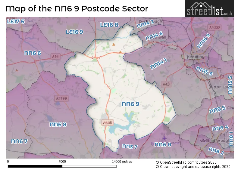
The NN6 9 postcode sector is within the county of Northamptonshire.
Did you know? According to the 2021 Census, the NN6 9 postcode sector is home to a bustling 9,935 residents!
Given that each sector allows for 400 unique postcode combinations. Letters C, I, K, M, O and V are not allowed in the last two letters of a postcode. With 310 postcodes already in use, this leaves 90 units available.
The largest settlement in the NN6 9 postal code is Brixworth followed by Walgrave, and Pitsford.
The NN6 9 Postcode shares a border with NN14 6 (Rothwell), NN3 7 (Moulton), NN6 0 (Earls Barton, Overstone, Sywell), NN6 6 (Welford, Naseby, Yelvertoft), NN2 8 (NORTHAMPTON, Boughton), NN6 8 (Spratton, East Haddon, Chapel Brampton), NN9 5 (Irthlingborough, Finedon, WELLINGBOROUGH), NN14 1 (Broughton, Mawsley, Geddington), NN14 2 (Desborough), LE16 8 (MARKET HARBOROUGH, Cottingham, Great Easton) and LE16 9 (MARKET HARBOROUGH, Lubenham, Clipston).
The sector is within the post town of NORTHAMPTON.
NN6 9 is a postcode sector within the NN6 postcode district which is within the NN Northampton postcode area.
The Royal Mail delivery office for the NN6 9 postal sector is the Northampton Rurals Delivery Office and Hanging Houghton Scale Payment Delivery Office and Walgrave Scale Payment Delivery Office.
The area of the NN6 9 postcode sector is 45.74 square miles which is 118.47 square kilometres or 29,273.54 square acres.
The NN6 9 postcode sector is crossed by the A14 Major A road.
Waterways within the NN6 9 postcode sector include the Ise.

Map of the NN6 9 Postcode Sector
Explore the NN6 9 postcode sector by using our free interactive map.
| N | N | 6 | - | 9 | X | X |
| N | N | 6 | Space | 9 | Letter | Letter |
Official List of Streets
Brixworth (102 Streets)
Walgrave (31 Streets)
Holcot (14 Streets)
Scaldwell (12 Streets)
Old (16 Streets)
Maidwell (5 Streets)
Hannington (13 Streets)
Pitsford (14 Streets)
Harrington (3 Streets)
Haselbech (4 Streets)
Lamport (5 Streets)
Kelmarsh (2 Streets)
Hanging Houghton (6 Streets)
Draughton (1 Streets)
Thorpe Underwood (1 Streets)
Unofficial Streets or Alternative Spellings
Mawsley
BROUGHTON ROAD LODDINGTON WAY BRACKEN BOROUGH BRAMPTON VALLEY WAY BRIXWORTH BYPASS BROOME CROFT CENTENERY WAY DESBOROUGH ROAD DOG WALKERS PATH DOGGERS LANE HASELBECH ROAD KELMARSH TUNNEL LODGE FARM ROAD MANOR FARM MAWSLEY ROAD MERCEDES AVENUE MOULTON LODGE ROAD NASBY ROAD NORTHAMPTON NORTHERN ORBITAL ROUTES OLD CART ROAD PITSFORD WATER CIRCUIT REDHOUSE ROAD SAINT DAVIDS ROAD SPRING HILL TITHE FARM ROAD TURNER FARM CLOSE WATERPIKEDesborough
ARTHINGWORTH ROADMoulton
HOLCOT ROAD PITSFORD ROAD SPECTACLE LANEChapel Brampton
BRAMPTON LANE MERRY TOM LANESpratton
BRIXWORTH ROADWeather Forecast for NN6 9
Press Button to Show Forecast for Rothwell (Northamptonshire)
| Time Period | Icon | Description | Temperature | Rain Probability | Wind |
|---|---|---|---|---|---|
| 00:00 to 03:00 | Clear night | 14.0°C (feels like 13.0°C) | 2.00% | SSE 4 mph | |
| 03:00 to 06:00 | Clear night | 12.0°C (feels like 12.0°C) | 1.00% | S 4 mph | |
| 06:00 to 09:00 | Cloudy | 13.0°C (feels like 12.0°C) | 6.00% | SSW 9 mph | |
| 09:00 to 12:00 | Cloudy | 16.0°C (feels like 14.0°C) | 4.00% | S 11 mph | |
| 12:00 to 15:00 | Partly cloudy (day) | 19.0°C (feels like 16.0°C) | 1.00% | S 13 mph | |
| 15:00 to 18:00 | Cloudy | 20.0°C (feels like 16.0°C) | 7.00% | S 13 mph | |
| 18:00 to 21:00 | Cloudy | 18.0°C (feels like 16.0°C) | 8.00% | SSE 11 mph | |
| 21:00 to 00:00 | Cloudy | 15.0°C (feels like 14.0°C) | 10.00% | SE 9 mph |
Press Button to Show Forecast for Rothwell (Northamptonshire)
| Time Period | Icon | Description | Temperature | Rain Probability | Wind |
|---|---|---|---|---|---|
| 00:00 to 03:00 | Cloudy | 14.0°C (feels like 12.0°C) | 20.00% | ESE 9 mph | |
| 03:00 to 06:00 | Light rain | 13.0°C (feels like 12.0°C) | 49.00% | ESE 9 mph | |
| 06:00 to 09:00 | Light rain | 13.0°C (feels like 12.0°C) | 54.00% | ESE 9 mph | |
| 09:00 to 12:00 | Heavy rain | 15.0°C (feels like 13.0°C) | 79.00% | ESE 11 mph | |
| 12:00 to 15:00 | Heavy rain | 16.0°C (feels like 14.0°C) | 79.00% | SE 11 mph | |
| 15:00 to 18:00 | Light rain shower (day) | 16.0°C (feels like 14.0°C) | 48.00% | SSE 11 mph | |
| 18:00 to 21:00 | Cloudy | 15.0°C (feels like 14.0°C) | 23.00% | SSE 9 mph | |
| 21:00 to 00:00 | Cloudy | 13.0°C (feels like 12.0°C) | 13.00% | SE 7 mph |
Press Button to Show Forecast for Rothwell (Northamptonshire)
| Time Period | Icon | Description | Temperature | Rain Probability | Wind |
|---|---|---|---|---|---|
| 00:00 to 03:00 | Cloudy | 12.0°C (feels like 10.0°C) | 5.00% | SE 7 mph | |
| 03:00 to 06:00 | Cloudy | 11.0°C (feels like 10.0°C) | 6.00% | ESE 7 mph | |
| 06:00 to 09:00 | Cloudy | 12.0°C (feels like 11.0°C) | 10.00% | ESE 7 mph | |
| 09:00 to 12:00 | Cloudy | 15.0°C (feels like 14.0°C) | 15.00% | SE 9 mph | |
| 12:00 to 15:00 | Light rain shower (day) | 17.0°C (feels like 16.0°C) | 39.00% | SE 9 mph | |
| 15:00 to 18:00 | Cloudy | 18.0°C (feels like 16.0°C) | 15.00% | SE 9 mph | |
| 18:00 to 21:00 | Sunny day | 17.0°C (feels like 16.0°C) | 8.00% | SE 7 mph | |
| 21:00 to 00:00 | Clear night | 13.0°C (feels like 12.0°C) | 2.00% | SE 4 mph |
Press Button to Show Forecast for Rothwell (Northamptonshire)
| Time Period | Icon | Description | Temperature | Rain Probability | Wind |
|---|---|---|---|---|---|
| 00:00 to 03:00 | Clear night | 11.0°C (feels like 10.0°C) | 1.00% | SSE 4 mph | |
| 03:00 to 06:00 | Clear night | 9.0°C (feels like 8.0°C) | 1.00% | S 4 mph | |
| 06:00 to 09:00 | Partly cloudy (day) | 11.0°C (feels like 11.0°C) | 2.00% | WSW 4 mph | |
| 09:00 to 12:00 | Partly cloudy (day) | 16.0°C (feels like 15.0°C) | 5.00% | SE 4 mph | |
| 12:00 to 15:00 | Cloudy | 18.0°C (feels like 17.0°C) | 11.00% | S 7 mph | |
| 15:00 to 18:00 | Cloudy | 19.0°C (feels like 18.0°C) | 31.00% | SSW 7 mph | |
| 18:00 to 21:00 | Sunny day | 18.0°C (feels like 17.0°C) | 10.00% | W 4 mph | |
| 21:00 to 00:00 | Partly cloudy (night) | 13.0°C (feels like 13.0°C) | 3.00% | WSW 4 mph |
Schools and Places of Education Within the NN6 9 Postcode Sector
Brixworth CofE VC Primary School
Voluntary controlled school
Froxhill Crescent, Northampton, Northamptonshire, NN6 9BG
Head: Mr Neil Tyler
Ofsted Rating: Good
Inspection: 2023-03-22 (418 days ago)
Website: Visit Brixworth CofE VC Primary School Website
Phone: 01604883900
Number of Pupils: 489
Maidwell Primary School
Community school
Draughton Road, Northampton, Northamptonshire, NN6 9JF
Head: Mr Geoff Woods
Ofsted Rating: Outstanding
Inspection: 2014-05-08 (3658 days ago)
Website: Visit Maidwell Primary School Website
Phone: 01604686240
Number of Pupils: 68
Pitsford Primary School
Community school
Moulton Road, Northampton, Northamptonshire, NN6 9AU
Head: Ms Julia Hyde
Ofsted Rating: Good
Inspection: 2023-04-20 (389 days ago)
Website: Visit Pitsford Primary School Website
Phone: 01604880866
Number of Pupils: 58
Walgrave Primary School
Community school
Kettering Road, Northampton, Northamptonshire, NN6 9PH
Head: Ms Julia Hyde
Ofsted Rating: Good
Inspection: 2019-09-12 (1705 days ago)
Website: Visit Walgrave Primary School Website
Phone: 01604781275
Number of Pupils: 144
House Prices in the NN6 9 Postcode Sector
| Type of Property | 2018 Average | 2018 Sales | 2017 Average | 2017 Sales | 2016 Average | 2016 Sales | 2015 Average | 2015 Sales |
|---|---|---|---|---|---|---|---|---|
| Detached | £408,154 | 110 | £418,908 | 86 | £360,777 | 75 | £348,660 | 100 |
| Semi-Detached | £264,383 | 48 | £262,273 | 51 | £232,169 | 52 | £242,958 | 51 |
| Terraced | £262,673 | 19 | £233,196 | 38 | £216,655 | 35 | £203,338 | 31 |
| Flats | £104,938 | 2 | £80,190 | 5 | £140,748 | 2 | £112,332 | 3 |
Important Postcodes NN6 9 in the Postcode Sector
NN6 9AU is the postcode for Pitsford Primary School, Moulton Road
NN6 9BG is the postcode for Brixworth VC Primary School, Froxhill Crescent
NN6 9DA is the postcode for Boniface House, Spratton Road, Brixworth
NN6 9DG is the postcode for Brixworth Country Park, Northampton Road, Brixworth, and VISITORS CENTRE, Brixworth Country Park, Northampton Road
NN6 9DS is the postcode for Brixworth Library, Spratton Road, Northamptonshire County Council, Brixworth Library, Spratton Road, and Boniface House, Spratton Road
NN6 9JF is the postcode for Maidwell Primary School, Draughton Road
NN6 9PH is the postcode for Walgrave Cp School, Kettering Road
| The NN6 9 Sector is within these Local Authorities |
|
|---|---|
| The NN6 9 Sector is within these Counties |
|
| The NN6 9 Sector is within these Water Company Areas |
|
Tourist Attractions within the NN6 9 Postcode Area
We found 1 visitor attractions within the NN6 postcode area
| Harrington Aviation Museum |
|---|
| Museums & Art Galleries |
| Museum and / or Art Gallery |
| View Harrington Aviation Museum on Google Maps |