The NN18 postcode district is a postal district located in the NN Northampton postcode area with a population of 40,310 residents according to the 2021 England and Wales Census.
The area of the NN18 postcode district is 9.34 square miles which is 24.20 square kilometres or 5,979.24 acres.
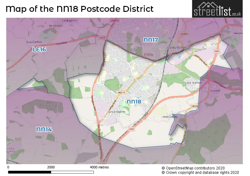
Currently, the NN18 district has about 649 postcode units spread across 3 geographic postcode sectors.
Given that each sector allows for 400 unique postcode combinations, the district has a capacity of 1,200 postcodes. With 649 postcodes already in use, this leaves 551 units available.
The largest settlements in the NN18 postal code are CORBY and Great Oakley.
The NN18 Postcode shares a border with LE16 (MARKET HARBOROUGH, Great Bowden, Lubenham), NN14 (Desborough, Rothwell, Thrapston) and NN17 (CORBY, Weldon, Gretton).
The NN18 postcode district primarily includes the settlement of Corby in the county of Northamptonshire, England. Other significant settlements in the area include Great Oakley, Little Oakley, St. James Industrial Estate, and Weldon South Industrial Estate. The most significant post town in this postcode district is Corby.
For the district NN18, we have data on 3 postcode sectors. Here's a breakdown: The sector NN18 0, covers Corby in Northamptonshire. The sector NN18 8, covers Corby and Great Oakley in Northamptonshire. The sector NN18 9, covers Corby in Northamptonshire.


Map of the NN18 Postcode District
Explore the NN18 postcode district by using our free interactive map.
When it comes to local government, postal geography often disregards political borders. However, for a breakdown in the NN18 District: the district mostly encompasses the North Northamptonshire area with a total of 653 postcodes.
Recent House Sales in NN18
| Date | Price | Address |
|---|---|---|
| 29/09/2023 | £220,000 | Conyger Close, Great Oakley, Corby, NN18 8FW |
| 29/09/2023 | £190,000 | Clarendon Close, Corby, NN18 8DD |
| 08/09/2023 | £350,000 | Lyveden Way, Corby, NN18 8PH |
| 07/09/2023 | £175,000 | Buckfast Square, Corby, NN18 8DT |
| 01/09/2023 | £100,000 | Blenheim Walk, Corby, NN18 9HA |
| 01/09/2023 | £250,000 | Jay Road, Corby, NN18 8RP |
| 31/08/2023 | £225,000 | Oak Wood Drive, Corby, NN18 9BZ |
| 30/08/2023 | £325,000 | Kingsbrook, Corby, NN18 9HY |
| 25/08/2023 | £107,000 | Pickering Court, Corby, NN18 0QS |
| 25/08/2023 | £217,800 | Blackbird Road, Corby, NN18 8FE |
Weather Forecast for NN18
Press Button to Show Forecast for Corby
| Time Period | Icon | Description | Temperature | Rain Probability | Wind |
|---|---|---|---|---|---|
| 12:00 to 15:00 | Cloudy | 8.0°C (feels like 6.0°C) | 8.00% | ENE 7 mph | |
| 15:00 to 18:00 | Cloudy | 9.0°C (feels like 7.0°C) | 6.00% | ENE 7 mph | |
| 18:00 to 21:00 | Cloudy | 8.0°C (feels like 5.0°C) | 4.00% | ENE 9 mph | |
| 21:00 to 00:00 | Cloudy | 6.0°C (feels like 3.0°C) | 5.00% | ENE 7 mph |
Press Button to Show Forecast for Corby
| Time Period | Icon | Description | Temperature | Rain Probability | Wind |
|---|---|---|---|---|---|
| 00:00 to 03:00 | Cloudy | 5.0°C (feels like 3.0°C) | 7.00% | ENE 7 mph | |
| 03:00 to 06:00 | Cloudy | 4.0°C (feels like 2.0°C) | 7.00% | NE 7 mph | |
| 06:00 to 09:00 | Cloudy | 5.0°C (feels like 2.0°C) | 10.00% | NE 7 mph | |
| 09:00 to 12:00 | Cloudy | 7.0°C (feels like 4.0°C) | 16.00% | ENE 9 mph | |
| 12:00 to 15:00 | Overcast | 9.0°C (feels like 6.0°C) | 19.00% | ENE 11 mph | |
| 15:00 to 18:00 | Overcast | 8.0°C (feels like 5.0°C) | 13.00% | NE 13 mph | |
| 18:00 to 21:00 | Overcast | 7.0°C (feels like 4.0°C) | 14.00% | NE 11 mph | |
| 21:00 to 00:00 | Mist | 6.0°C (feels like 3.0°C) | 23.00% | NE 11 mph |
Press Button to Show Forecast for Corby
| Time Period | Icon | Description | Temperature | Rain Probability | Wind |
|---|---|---|---|---|---|
| 00:00 to 03:00 | Drizzle | 6.0°C (feels like 3.0°C) | 56.00% | NNE 13 mph | |
| 03:00 to 06:00 | Heavy rain | 6.0°C (feels like 2.0°C) | 89.00% | NNE 13 mph | |
| 06:00 to 09:00 | Heavy rain | 6.0°C (feels like 2.0°C) | 92.00% | N 13 mph | |
| 09:00 to 12:00 | Heavy rain | 7.0°C (feels like 3.0°C) | 87.00% | NNW 11 mph | |
| 12:00 to 15:00 | Light rain | 8.0°C (feels like 4.0°C) | 58.00% | NW 11 mph | |
| 15:00 to 18:00 | Overcast | 9.0°C (feels like 7.0°C) | 17.00% | WNW 9 mph | |
| 18:00 to 21:00 | Cloudy | 9.0°C (feels like 7.0°C) | 9.00% | WSW 7 mph | |
| 21:00 to 00:00 | Partly cloudy (night) | 7.0°C (feels like 4.0°C) | 2.00% | SW 7 mph |
Press Button to Show Forecast for Corby
| Time Period | Icon | Description | Temperature | Rain Probability | Wind |
|---|---|---|---|---|---|
| 00:00 to 03:00 | Clear night | 5.0°C (feels like 3.0°C) | 1.00% | SW 7 mph | |
| 03:00 to 06:00 | Clear night | 4.0°C (feels like 1.0°C) | 1.00% | SSW 7 mph | |
| 06:00 to 09:00 | Sunny day | 5.0°C (feels like 2.0°C) | 1.00% | S 7 mph | |
| 09:00 to 12:00 | Partly cloudy (day) | 11.0°C (feels like 8.0°C) | 1.00% | S 11 mph | |
| 12:00 to 15:00 | Cloudy | 13.0°C (feels like 10.0°C) | 5.00% | S 13 mph | |
| 15:00 to 18:00 | Partly cloudy (day) | 14.0°C (feels like 11.0°C) | 2.00% | S 11 mph | |
| 18:00 to 21:00 | Sunny day | 13.0°C (feels like 11.0°C) | 1.00% | S 9 mph | |
| 21:00 to 00:00 | Clear night | 9.0°C (feels like 7.0°C) | 1.00% | SSE 9 mph |
Press Button to Show Forecast for Corby
| Time Period | Icon | Description | Temperature | Rain Probability | Wind |
|---|---|---|---|---|---|
| 00:00 to 03:00 | Clear night | 7.0°C (feels like 5.0°C) | 2.00% | SE 7 mph | |
| 03:00 to 06:00 | Clear night | 6.0°C (feels like 4.0°C) | 2.00% | ESE 7 mph | |
| 06:00 to 09:00 | Sunny day | 7.0°C (feels like 5.0°C) | 6.00% | ESE 7 mph | |
| 09:00 to 12:00 | Cloudy | 12.0°C (feels like 10.0°C) | 5.00% | ESE 9 mph | |
| 12:00 to 15:00 | Cloudy | 15.0°C (feels like 13.0°C) | 8.00% | SE 11 mph | |
| 15:00 to 18:00 | Cloudy | 16.0°C (feels like 14.0°C) | 15.00% | ESE 11 mph | |
| 18:00 to 21:00 | Light rain shower (day) | 14.0°C (feels like 13.0°C) | 31.00% | ESE 9 mph | |
| 21:00 to 00:00 | Cloudy | 11.0°C (feels like 10.0°C) | 9.00% | E 7 mph |
Where is the NN18 Postcode District?
The postcode district NN18 is located in Corby, a town in Northamptonshire. It is situated near several nearby towns: Kettering to the south (4.63 miles away), Market Harborough to the west (8.49 miles away), Oakham to the north (12.27 miles away), Rushden to the southeast (14.03 miles away), Stamford to the northeast (15.86 miles away), Northampton to the southwest (17.66 miles away), Wigston to the northwest (18.56 miles away), and Peterborough to the east (19.91 miles away). The district is approximately 71.07 miles away from the center of London.
The district is within the post town of CORBY.
The sector has postcodes within the nation of England.
The NN18 Postcode District is in the North Northamptonshire region of Leicestershire, Rutland and Northamptonshire within the East Midlands (England).
| Postcode Sector | Delivery Office |
|---|---|
| NN18 0 | Corby Delivery Office |
| NN18 8 | Corby Delivery Office |
| NN18 9 | Corby Delivery Office |
| N | N | 1 | 8 | - | X | X | X |
| N | N | 1 | 8 | Space | Numeric | Letter | Letter |
Current Monthly Rental Prices
| # Bedrooms | Min Price | Max Price | Avg Price |
|---|---|---|---|
| £412 | £758 | £536 | |
| 1 | £450 | £850 | £684 |
| 2 | £800 | £867 | £834 |
| 3 | £925 | £1,100 | £1,006 |
| 4 | £1,100 | £1,100 | £1,100 |
| 5 | £390 | £520 | £455 |
Current House Prices
| # Bedrooms | Min Price | Max Price | Avg Price |
|---|---|---|---|
| £5,000 | £137,500 | £71,250 | |
| 1 | £90,000 | £155,000 | £126,238 |
| 2 | £110,000 | £244,950 | £184,442 |
| 3 | £115,000 | £395,000 | £242,561 |
| 4 | £175,000 | £525,000 | £335,138 |
| 5 | £180,000 | £480,000 | £350,675 |
Estate Agents who Operate in the NN18 District
| Logo | Name | Brand Name | Address | Contact Number | Total Properties |
|---|---|---|---|---|---|
 | Corby | Simpson West | 64 Corporation Street, Corby, NN17 1NH | 01536 907561 | 78 |
 | Corby | Stuart Charles Estate Agents | 47 Corporation Street, Corby, NN17 1NQ | 01536 907867 | 41 |
 | Corby | Henderson Connellan | 10 Spencer Court Corby NN17 1NU | 01536 907238 | 36 |
 | Oakley Vale | Connells | 10 Charter Court, Butland Rd, Oakley Vale, Northants, NN18 8QT | 01536 907964 | 19 |
 | Corby | Oscar James | 13 New Post Office Square, Corby, NN17 1PB | 01536 907455 | 18 |
| Type of Property | 2018 Average | 2018 Sales | 2017 Average | 2017 Sales | 2016 Average | 2016 Sales | 2015 Average | 2015 Sales |
|---|---|---|---|---|---|---|---|---|
| Detached | £259,487 | 251 | £247,686 | 268 | £228,665 | 223 | £202,673 | 234 |
| Semi-Detached | £174,022 | 294 | £164,854 | 212 | £151,997 | 182 | £145,033 | 178 |
| Terraced | £152,541 | 228 | £143,235 | 264 | £132,122 | 303 | £117,380 | 262 |
| Flats | £111,779 | 37 | £99,076 | 44 | £94,058 | 43 | £85,779 | 56 |