
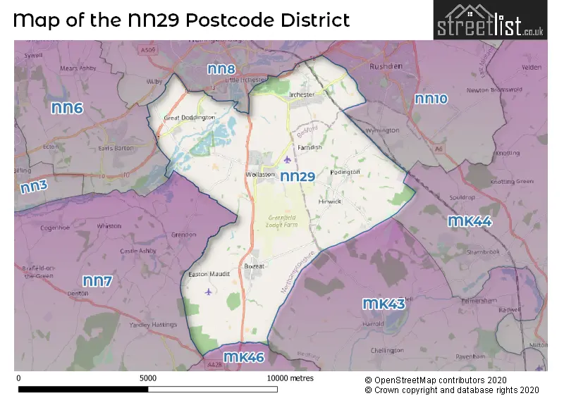
Map of the Postcode District
Explore the postcode district by using our interactive map.
Circles represent recorded crime; the larger the circle, the higher the crime rates.
Your support helps keep this site running!
If you enjoy using this website, consider buying me a coffee to help cover hosting costs.
The postcode district located in the NN Northampton postal area , NN29 has a population of 11,812 residents according to the 2021 England and Wales Census.
The area of the district is 24.49 square miles (63.44 square kilometers or 15,676.42 acres).
Where is the NN29 District?
To give you an idea where the district is located we have created the following table showing nearby towns.
Nearest Towns to NN29
| Town | Distance (miles) | Direction |
|---|---|---|
| Wellingborough | 3.87 | NNW |
| Rushden | 4.06 | NE |
| Higham Ferrers | 4.94 | NE |
| Irthlingborough | 5.83 | NNE |
| Olney | 6.47 | SSW |
| Burton Latimer | 7.90 | N |
| Raunds | 8.66 | NE |
| Northampton | 9.81 | W |
| Kettering | 10.80 | NNW |
| Bedford | 11.37 | SE |
| Newport Pagnell | 11.46 | SSW |
| Kempston | 11.53 | SE |
| Thrapston | 11.57 | NNE |
| Wixams | 13.88 | SE |
| Milton Keynes | 14.73 | SSW |
| Desborough | 14.91 | NNW |
| Towcester | 15.96 | WSW |
| Woburn Sands | 16.11 | S |
| Corby | 16.59 | N |
| Ampthill | 16.68 | SSE |
The post town for this district is WELLINGBOROUGH.
Postcode Information for District NN29 (Total Geographical Postcodes: 279)
| Location | Post Town | Sector | Number of Postcodes |
|---|---|---|---|
| Wollaston | WELLINGBOROUGH | NN29 7 | 91 |
| Irchester | WELLINGBOROUGH | NN29 7 | 82 |
| Bozeat | WELLINGBOROUGH | NN29 7 | 58 |
| Great Doddington | WELLINGBOROUGH | NN29 7 | 23 |
| Podington | WELLINGBOROUGH | NN29 7 | 8 |
| Knuston | WELLINGBOROUGH | NN29 7 | 7 |
| Hinwick | WELLINGBOROUGH | NN29 7 | 4 |
| Strixton | WELLINGBOROUGH | NN29 7 | 3 |
| Easton Maudit | WELLINGBOROUGH | NN29 7 | 2 |
| Farndish | WELLINGBOROUGH | NN29 7 | 1 |
Retail and Shopping in NN29
Street
Town
Locality
Number of Shops
Central Postcode
View on Google Maps
NEWTON ROAD
WELLINGBOROUGH
WOLLASTON
7
NN29 7QN
View on Google Maps
HIGH STREET
WELLINGBOROUGH
IRCHESTER
6
NN29 7AB
View on Google Maps
WOLLASTON ROAD
WELLINGBOROUGH
IRCHESTER
6
NN29 7DE
View on Google Maps
| Street | Town | Locality | Number of Shops | Central Postcode | View on Google Maps |
|---|---|---|---|---|---|
| NEWTON ROAD | WELLINGBOROUGH | WOLLASTON | 7 | NN29 7QN | View on Google Maps |
| HIGH STREET | WELLINGBOROUGH | IRCHESTER | 6 | NN29 7AB | View on Google Maps |
| WOLLASTON ROAD | WELLINGBOROUGH | IRCHESTER | 6 | NN29 7DE | View on Google Maps |
The primary settlement in the NN29 postcode district is Wollaston, located in the county of Northamptonshire in the East Midlands region of England. Other significant settlements in the district include Irchester, Great Doddington, and Knuston, also located in Northamptonshire. The post town for this district is Wellingborough.
When it comes to local government, postal geography often disregards political borders. However, this district intersects the following councils: the district mostly encompasses the North Northamptonshire (265 postal codes), and finally, the Bedford (B) area (14 postal codes).
The largest settlement in the NN29 postal code is Irchester followed by Wollaston, and Bozeat.
The NN29 Postcode shares a border with MK43 (Cranfield, Wootton, Marston Moretaine), MK46 (OLNEY, Lavendon, Emberton), NN10 (RUSHDEN, Higham Ferrers, Wymington), NN6 (Earls Barton, Brixworth, Long Buckby), NN7 (Weedon, Roade, Bugbrooke) and NN8 (WELLINGBOROUGH, Finedon Road Industrial Estate, Wilby).
Postcode Sectors


Schools in the Sector
Irchester Community Primary School
Phase: Primary
Address: School Lane , Irchester , Wellingborough
Postcode: NN29 7AZ
Headteacher: Mrs Julia Alison (Headteacher)
Ofsted Rating: Good
Irchester Community Primary School
Phase: Primary
Address: School Lane , Irchester , Wellingborough
Postcode: NN29 7AZ
Headteacher: Mr Simon Anderson (Headteacher)
Ofsted Rating: Good
Christopher Reeves CofE VA Primary School
Phase: Primary
Address: Hinwick Road , Podington , Wellingborough
Postcode: NN29 7HU
Headteacher: Mrs Sarah Bush (Acting Headteacher)
Ofsted Rating: Good
Bozeat Community Primary School
Phase: Primary
Address: Harrold Road , Bozeat , Wellingborough
Postcode: NN29 7LP
Headteacher: Ms Gillian Morton (Head Teacher)
Ofsted Rating: Requires improvement
Bozeat Community Primary School
Phase: Primary
Address: Harrold Road , Bozeat , Wellingborough
Postcode: NN29 7LP
Headteacher: Mr Gareth Rust (Head Teacher)
Ofsted Rating: Good
Wollaston School
Phase: Secondary
Address: Irchester Road , Wollaston , Wellingborough
Postcode: NN29 7PH
Headteacher: Mr James Birkett (Headteacher)
Ofsted Rating: Good
Wollaston School
Phase: Secondary
Address: Irchester Road , Wollaston , Wellingborough
Postcode: NN29 7PH
Headteacher: Mr Simon Anderson (Headteacher)
Ofsted Rating: Good
Wollaston Community Primary School
Phase: Primary
Address: College Street , Wollaston , Wellingborough
Postcode: NN29 7SF
Headteacher: Mrs Sally Hamson (Headteacher)
Ofsted Rating: Good
Wollaston Primary School
Phase: Primary
Address: College Street , Wollaston , Wellingborough
Postcode: NN29 7SF
Headteacher: Mrs Zoe Richards (Headteacher)
Ofsted Rating: Good
Great Doddington Primary
Phase: Primary
Address: Church Lane , Great Doddington , Wellingborough
Postcode: NN29 7TR
Headteacher: Mrs Josie Garnham ()
Ofsted Rating: Requires improvement
Stations in the Sector
No stations found in this postcode district.
Accessable Motorway Junctions
M1 J15
Average Driving Time from within the district: 16.11
Average Driving Distance: 14.66
Number of Postcodes that can access the Motorway Junction: 277
M1 J15A
Average Driving Time from within the district: 18.73
Average Driving Distance: 16.09
Number of Postcodes that can access the Motorway Junction: 277
M1 J14
Average Driving Time from within the district: 20.00
Average Driving Distance: 15.42
Number of Postcodes that can access the Motorway Junction: 277
M1 J16
Average Driving Time from within the district: 22.25
Average Driving Distance: 20.88
Number of Postcodes that can access the Motorway Junction: 272
M1 J13
Average Driving Time from within the district: 23.59
Average Driving Distance: 19.53
Number of Postcodes that can access the Motorway Junction: 212
A1(M) J13
Average Driving Time from within the district: 28.97
Average Driving Distance: 25.48
Number of Postcodes that can access the Motorway Junction: 66
A1(M) J14
Average Driving Time from within the district: 37.61
Average Driving Distance: 34.51
Number of Postcodes that can access the Motorway Junction: 4
Weather Forecast for Santa Pod Raceway
| Time Period | Icon | Description | Temperature | Rain Probability | Wind |
|---|---|---|---|---|---|
| 12:00 to 15:00 | Cloudy | 13.0°C (feels like 11.0°C) | 9.00% | WSW 11 mph | |
| 15:00 to 18:00 | Cloudy | 14.0°C (feels like 14.0°C) | 9.00% | WSW 4 mph | |
| 18:00 to 21:00 | Clear night | 11.0°C (feels like 11.0°C) | 0.00% | SW 4 mph | |
| 21:00 to 00:00 | Clear night | 9.0°C (feels like 8.0°C) | 0.00% | SSW 4 mph |
| Time Period | Icon | Description | Temperature | Rain Probability | Wind |
|---|---|---|---|---|---|
| 00:00 to 03:00 | Clear night | 9.0°C (feels like 8.0°C) | 1.00% | SSW 4 mph | |
| 03:00 to 06:00 | Mist | 8.0°C (feels like 6.0°C) | 13.00% | SSW 4 mph | |
| 06:00 to 09:00 | Fog | 8.0°C (feels like 6.0°C) | 15.00% | SSW 4 mph | |
| 09:00 to 12:00 | Fog | 10.0°C (feels like 8.0°C) | 13.00% | SSW 7 mph | |
| 12:00 to 15:00 | Cloudy | 14.0°C (feels like 12.0°C) | 3.00% | SSW 9 mph | |
| 15:00 to 18:00 | Partly cloudy (day) | 14.0°C (feels like 13.0°C) | 1.00% | S 9 mph | |
| 18:00 to 21:00 | Clear night | 12.0°C (feels like 11.0°C) | 0.00% | SSE 7 mph | |
| 21:00 to 00:00 | Clear night | 10.0°C (feels like 9.0°C) | 0.00% | SSE 9 mph |
| Time Period | Icon | Description | Temperature | Rain Probability | Wind |
|---|---|---|---|---|---|
| 00:00 to 03:00 | Clear night | 10.0°C (feels like 8.0°C) | 1.00% | SSE 9 mph | |
| 03:00 to 06:00 | Clear night | 9.0°C (feels like 7.0°C) | 1.00% | SSE 9 mph | |
| 06:00 to 09:00 | Clear night | 9.0°C (feels like 7.0°C) | 1.00% | SSE 9 mph | |
| 09:00 to 12:00 | Partly cloudy (day) | 11.0°C (feels like 9.0°C) | 2.00% | SSE 11 mph | |
| 12:00 to 15:00 | Overcast | 14.0°C (feels like 11.0°C) | 7.00% | SSE 13 mph | |
| 15:00 to 18:00 | Partly cloudy (day) | 15.0°C (feels like 13.0°C) | 1.00% | S 13 mph | |
| 18:00 to 21:00 | Cloudy | 13.0°C (feels like 11.0°C) | 4.00% | SSE 11 mph | |
| 21:00 to 00:00 | Partly cloudy (night) | 13.0°C (feels like 11.0°C) | 7.00% | SSE 11 mph |
| Time Period | Icon | Description | Temperature | Rain Probability | Wind |
|---|---|---|---|---|---|
| 00:00 to 03:00 | Cloudy | 13.0°C (feels like 11.0°C) | 24.00% | S 11 mph | |
| 03:00 to 06:00 | Cloudy | 12.0°C (feels like 10.0°C) | 21.00% | SSW 11 mph | |
| 06:00 to 09:00 | Partly cloudy (night) | 11.0°C (feels like 9.0°C) | 11.00% | SSW 11 mph | |
| 09:00 to 12:00 | Partly cloudy (day) | 11.0°C (feels like 9.0°C) | 8.00% | SSW 11 mph | |
| 12:00 to 15:00 | Light rain shower (day) | 13.0°C (feels like 10.0°C) | 33.00% | SSW 13 mph | |
| 15:00 to 18:00 | Light rain shower (day) | 12.0°C (feels like 10.0°C) | 32.00% | SW 11 mph | |
| 18:00 to 21:00 | Clear night | 10.0°C (feels like 8.0°C) | 3.00% | SW 11 mph | |
| 21:00 to 00:00 | Clear night | 9.0°C (feels like 6.0°C) | 4.00% | SW 11 mph |
| Time Period | Icon | Description | Temperature | Rain Probability | Wind |
|---|---|---|---|---|---|
| 00:00 to 03:00 | Clear night | 8.0°C (feels like 5.0°C) | 3.00% | SW 11 mph | |
| 03:00 to 06:00 | Partly cloudy (night) | 8.0°C (feels like 5.0°C) | 5.00% | SW 11 mph | |
| 06:00 to 09:00 | Partly cloudy (night) | 8.0°C (feels like 5.0°C) | 9.00% | SW 11 mph | |
| 09:00 to 12:00 | Partly cloudy (day) | 10.0°C (feels like 7.0°C) | 9.00% | SW 13 mph | |
| 12:00 to 15:00 | Cloudy | 12.0°C (feels like 9.0°C) | 15.00% | SW 13 mph | |
| 15:00 to 18:00 | Cloudy | 12.0°C (feels like 10.0°C) | 33.00% | SW 13 mph | |
| 18:00 to 21:00 | Cloudy | 11.0°C (feels like 9.0°C) | 10.00% | SW 11 mph | |
| 21:00 to 00:00 | Partly cloudy (night) | 11.0°C (feels like 8.0°C) | 6.00% | SW 11 mph |
| Postal Sector | Delivery Office |
|---|---|
| NN29 7 | Wellingborough Delivery Office |
| NN29 7 | Irchester Scale Payment Delivery Office |
| NN29 7 | Wollaston Scale Payment Delivery Office |
| NN29 7 | Bozeat Scale Payment Delivery Office |
| N | N | 2 | 9 | - | X | X | X |
| N | N | 2 | 9 | Space | Numeric | Letter | Letter |
Street List for the NN29 District
Current Monthly Rental Prices
| # Bedrooms | Min Price | Max Price | Avg Price |
|---|---|---|---|
| £3,500 | £3,500 | £3,500 | |
| 1 | £725 | £795 | £760 |
| 2 | £925 | £995 | £960 |
| 3 | £1,050 | £1,395 | £1,198 |
| 4 | £2,000 | £2,000 | £2,000 |
Current House Prices
| # Bedrooms | Min Price | Max Price | Avg Price |
|---|---|---|---|
| £260,000 | £2,000,000 | £953,333 | |
| 2 | £120,000 | £399,950 | £255,756 |
| 3 | £210,000 | £699,995 | £327,566 |
| 4 | £350,000 | £800,000 | £472,487 |
| 5 | £399,995 | £2,450,000 | £1,028,570 |
| 6 | £1,650,000 | £1,750,000 | £1,700,000 |
| 9 | £1,000,000 | £1,000,000 | £1,000,000 |
| 18 | £7,950,000 | £7,950,000 | £7,950,000 |
Estate Agents
| Logo | Name | Brand Name | Address | Contact Number |
|---|---|---|---|---|
 | Wollaston | Matthew Nicholas Estate Agents | 27- 29 Newton Road, Wollaston, NN29 7QN | 01933 823306 |
 | Steeple View Chase | Mulberry Homes | Steeple View Chase, Farndish Road, Irchester, NN29 7BL | 01604 279546 |
 | Rushden | Simpson & Weekley | 30 High Street, Rushden, NN10 0PW | 01933 823233 |
 | Summers Grange | Bloor Homes | Summers Grange, Hookhams Path, Wollaston, NN29 7PQ | 01933 823312 |
 | Rushden | William H. Brown | 52 High Street, Rushden, NN10 0PJ | 01933 823236 |
Yearly House Price Averages for the District
| Type of Property | 2018 Average | 2018 Sales | 2017 Average | 2017 Sales | 2016 Average | 2016 Sales | 2015 Average | 2015 Sales |
|---|---|---|---|---|---|---|---|---|
| Detached | £373,267 | 66 | £299,509 | 64 | £328,266 | 60 | £333,291 | 76 |
| Semi-Detached | £231,009 | 66 | £218,595 | 82 | £180,868 | 81 | £178,720 | 84 |
| Terraced | £201,890 | 55 | £195,135 | 51 | £174,981 | 64 | £174,136 | 58 |
| Flats | £108,999 | 7 | £138,914 | 7 | £119,333 | 6 | £108,500 | 10 |