The MK46 postcode district is a postal district located in the MK Milton Keynes postcode area with a population of 9,391 residents according to the 2021 England and Wales Census.
The area of the MK46 postcode district is 21.83 square miles which is 56.54 square kilometres or 13,970.60 acres.
Currently, the MK46 district has about 281 postcode units spread across 2 geographic postcode sectors.
Given that each sector allows for 400 unique postcode combinations, the district has a capacity of 800 postcodes. With 281 postcodes already in use, this leaves 519 units available.
The largest settlement in the MK46 postal code is OLNEY followed by Lavendon, and Emberton.
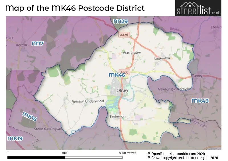
The MK46 Postcode shares a border with MK43 (Cranfield, Wootton, Marston Moretaine), MK16 (NEWPORT PAGNELL, Sherington, North Crawley), NN29 (Irchester, Wollaston, Bozeat) and NN7 (Weedon, Roade, Bugbrooke).
In the MK46 postcode district in Buckinghamshire, the primary settlement is Olney. Other significant settlements in the district include Cold Brayfield, Lavendon, Warrington, Clifton Reynes, Emberton, Ravenstone, and Weston Underwood. The most significant post town in this district is Olney.
For the district MK46, we have data on 2 postcode sectors. Here's a breakdown: The sector MK46 4, covers Olney and Lavendon in Buckinghamshire. The sector MK46 5, covers Olney and Emberton in Buckinghamshire.


Map of the MK46 Postcode District
Explore the MK46 postcode district by using our free interactive map.
When it comes to local government, postal geography often disregards political borders. However, for a breakdown in the MK46 District: the district mostly encompasses the Milton Keynes (B) area with a total of 304 postcodes.
Recent House Sales in MK46
| Date | Price | Address |
|---|---|---|
| 29/09/2023 | £697,000 | Longmire, Lavendon, Olney, MK46 4EG |
| 15/09/2023 | £362,500 | Rectory Orchard, Lavendon, Olney, MK46 4HB |
| 15/09/2023 | £322,000 | New Row, Lavendon, Olney, MK46 4EZ |
| 13/09/2023 | £300,000 | Spinney Hill Road, Olney, MK46 5AB |
| 13/09/2023 | £195,000 | Hoppers Hill, Olney, MK46 5FN |
| 12/09/2023 | £262,000 | Maybush Walk, Olney, MK46 5NA |
| 08/09/2023 | £290,000 | High Street, Lavendon, Olney, MK46 4HA |
| 06/09/2023 | £560,000 | Lilly Hill, Olney, MK46 5EZ |
| 04/09/2023 | £390,000 | Chantry Rise, Olney, MK46 5FE |
| 01/09/2023 | £685,000 | Osier Way, Olney, MK46 5FP |
Weather Forecast for MK46
Press Button to Show Forecast for Olney
| Time Period | Icon | Description | Temperature | Rain Probability | Wind |
|---|---|---|---|---|---|
| 09:00 to 12:00 | Overcast | 7.0°C (feels like 4.0°C) | 16.00% | ENE 11 mph | |
| 12:00 to 15:00 | Overcast | 9.0°C (feels like 6.0°C) | 14.00% | ENE 11 mph | |
| 15:00 to 18:00 | Overcast | 9.0°C (feels like 7.0°C) | 14.00% | NE 11 mph | |
| 18:00 to 21:00 | Overcast | 8.0°C (feels like 6.0°C) | 13.00% | NE 11 mph | |
| 21:00 to 00:00 | Overcast | 7.0°C (feels like 4.0°C) | 53.00% | NNE 11 mph |
Press Button to Show Forecast for Olney
| Time Period | Icon | Description | Temperature | Rain Probability | Wind |
|---|---|---|---|---|---|
| 00:00 to 03:00 | Heavy rain | 7.0°C (feels like 4.0°C) | 87.00% | NNE 13 mph | |
| 03:00 to 06:00 | Heavy rain | 7.0°C (feels like 3.0°C) | 90.00% | NNE 13 mph | |
| 06:00 to 09:00 | Heavy rain | 7.0°C (feels like 3.0°C) | 89.00% | N 13 mph | |
| 09:00 to 12:00 | Heavy rain | 7.0°C (feels like 4.0°C) | 81.00% | NNW 11 mph | |
| 12:00 to 15:00 | Light rain | 8.0°C (feels like 5.0°C) | 58.00% | WNW 13 mph | |
| 15:00 to 18:00 | Overcast | 10.0°C (feels like 7.0°C) | 20.00% | WNW 9 mph | |
| 18:00 to 21:00 | Cloudy | 10.0°C (feels like 8.0°C) | 8.00% | WSW 7 mph | |
| 21:00 to 00:00 | Partly cloudy (night) | 7.0°C (feels like 5.0°C) | 2.00% | SW 7 mph |
Press Button to Show Forecast for Olney
| Time Period | Icon | Description | Temperature | Rain Probability | Wind |
|---|---|---|---|---|---|
| 00:00 to 03:00 | Clear night | 6.0°C (feels like 3.0°C) | 1.00% | SW 7 mph | |
| 03:00 to 06:00 | Clear night | 4.0°C (feels like 2.0°C) | 1.00% | SSW 7 mph | |
| 06:00 to 09:00 | Sunny day | 5.0°C (feels like 3.0°C) | 1.00% | S 7 mph | |
| 09:00 to 12:00 | Partly cloudy (day) | 11.0°C (feels like 9.0°C) | 1.00% | S 11 mph | |
| 12:00 to 15:00 | Partly cloudy (day) | 13.0°C (feels like 11.0°C) | 4.00% | S 11 mph | |
| 15:00 to 18:00 | Sunny day | 14.0°C (feels like 12.0°C) | 2.00% | S 13 mph | |
| 18:00 to 21:00 | Sunny day | 13.0°C (feels like 11.0°C) | 1.00% | S 9 mph | |
| 21:00 to 00:00 | Clear night | 9.0°C (feels like 7.0°C) | 1.00% | SSE 7 mph |
Press Button to Show Forecast for Olney
| Time Period | Icon | Description | Temperature | Rain Probability | Wind |
|---|---|---|---|---|---|
| 00:00 to 03:00 | Clear night | 7.0°C (feels like 5.0°C) | 2.00% | SE 7 mph | |
| 03:00 to 06:00 | Clear night | 7.0°C (feels like 5.0°C) | 3.00% | ESE 7 mph | |
| 06:00 to 09:00 | Sunny day | 8.0°C (feels like 6.0°C) | 3.00% | ESE 7 mph | |
| 09:00 to 12:00 | Sunny day | 13.0°C (feels like 11.0°C) | 3.00% | ESE 9 mph | |
| 12:00 to 15:00 | Cloudy | 16.0°C (feels like 14.0°C) | 8.00% | SE 11 mph | |
| 15:00 to 18:00 | Cloudy | 16.0°C (feels like 14.0°C) | 10.00% | SE 11 mph | |
| 18:00 to 21:00 | Cloudy | 15.0°C (feels like 13.0°C) | 11.00% | ESE 9 mph | |
| 21:00 to 00:00 | Cloudy | 12.0°C (feels like 10.0°C) | 8.00% | ESE 7 mph |
Where is the MK46 Postcode District?
The postcode district MK46 is located in the town of Olney, which is situated in Buckinghamshire. Olney is surrounded by several nearby towns, including Newport Pagnell (5.11 miles south), Northampton (9.60 miles northwest), Rushden (10.01 miles northeast), Wellingborough (10.53 miles north), Bedford (11.26 miles east), Towcester (12.76 miles west), and Buckingham (15.98 miles southwest). Furthermore, Olney is approximately 51.24 miles away from the center of London.
The district is within the post town of OLNEY.
The sector has postcodes within the nation of England.
The MK46 Postcode District is covers the following regions.
- Milton Keynes - Berkshire, Buckinghamshire and Oxfordshire - South East (England)
- Bedford - Bedfordshire and Hertfordshire - East of England
| Postcode Sector | Delivery Office |
|---|---|
| MK46 4 | Newport Pagnell Delivery Office |
| MK46 4 | Olney Postal Delivery Office |
| MK46 5 | Newport Pagnell Delivery Office |
| MK46 5 | Olney Postal Delivery Office |
| M | K | 4 | 6 | - | X | X | X |
| M | K | 4 | 6 | Space | Numeric | Letter | Letter |
Current Monthly Rental Prices
| # Bedrooms | Min Price | Max Price | Avg Price |
|---|---|---|---|
| 2 | £1,000 | £1,495 | £1,323 |
| 3 | £1,300 | £1,350 | £1,325 |
| 4 | £1,795 | £2,500 | £2,148 |
| 5 | £2,800 | £2,800 | £2,800 |
Current House Prices
| # Bedrooms | Min Price | Max Price | Avg Price |
|---|---|---|---|
| 1 | £120,000 | £400,000 | £208,915 |
| 2 | £190,000 | £490,000 | £303,249 |
| 3 | £300,000 | £825,000 | £437,884 |
| 4 | £425,000 | £1,075,000 | £634,267 |
| 5 | £595,000 | £2,750,000 | £870,209 |
| 6 | £850,000 | £2,750,000 | £1,937,500 |
| 7 | £1,250,000 | £1,250,000 | £1,250,000 |
Estate Agents who Operate in the MK46 District
| Logo | Name | Brand Name | Address | Contact Number | Total Properties |
|---|---|---|---|---|---|
 | Olney | Michael Graham | Osborn House 20 High Street Olney MK46 4AA | 01234 230064 | 28 |
 | Olney | Stephen Oakley & Co | 35 High Street Olney MK46 4EB | 020 3835 2115 | 23 |
 | Milton Keynes | Fine & Country | 59 High Street, Stony Stratford, Milton Keynes, MK11 1AY | 01908 103415 | 7 |
 | Bedford | James Kendall | 1A Garricks Court Gold Furlong Marston Moretaine MK43 0XR | 01234 607491 | 5 |
 | Northampton | haart | 18 Bridge Street, Northampton, NN1 1NW | 01604 279693 | 5 |
| Type of Property | 2018 Average | 2018 Sales | 2017 Average | 2017 Sales | 2016 Average | 2016 Sales | 2015 Average | 2015 Sales |
|---|---|---|---|---|---|---|---|---|
| Detached | £499,608 | 71 | £472,964 | 64 | £554,525 | 70 | £431,584 | 59 |
| Semi-Detached | £322,513 | 37 | £355,721 | 42 | £373,035 | 28 | £293,875 | 28 |
| Terraced | £343,100 | 40 | £292,535 | 43 | £269,610 | 52 | £291,011 | 55 |
| Flats | £189,791 | 17 | £201,636 | 7 | £172,900 | 10 | £180,125 | 8 |