The MK43 postcode district is a postal district located in the MK Milton Keynes postcode area with a population of 42,493 residents according to the 2021 England and Wales Census.
The area of the MK43 postcode district is 72.33 square miles which is 187.33 square kilometres or 46,290.79 acres.
Currently, the MK43 district has about 1101 postcode units spread across 4 geographic postcode sectors.
Given that each sector allows for 400 unique postcode combinations, the district has a capacity of 1,600 postcodes. With 1101 postcodes already in use, this leaves 499 units available.
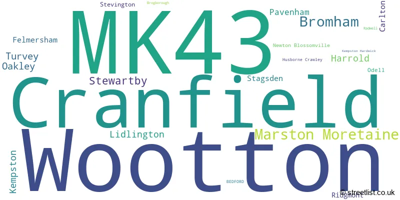
The largest settlement in the MK43 postal code is Cranfield followed by Wootton, and Marston Moretaine.
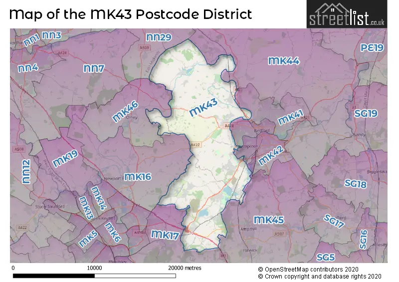
The MK43 Postcode shares a border with MK40 (BEDFORD, Great Denham, Biddenham), MK41 (BEDFORD, Clapham, Renhold), MK42 (BEDFORD, Kempston, Shortstown), MK44 (Sharnbrook, Great Barford, Riseley), MK45 (Flitwick, Ampthill, Barton-le-Clay), MK46 (OLNEY, Lavendon, Emberton), MK17 (Woburn Sands, Glebe Farm, Newton Longville), MK16 (NEWPORT PAGNELL, Sherington, North Crawley) and NN29 (Irchester, Wollaston, Bozeat).
In the MK43 postcode district, the primary settlement is Cranfield, located in the county of Bedfordshire, England. Other significant settlements in this district include Marston Moretaine, Lidlington, Ridgmont, and Brogborough, all located in the county of Bedfordshire. The most significant postal town in this district is Bedford.
For the district MK43, we have data on 7 postcode sectors. Here's a breakdown: The sector MK43 0, covers Cranfield and Marston Moretaine and Lidlington in Bedfordshire. The sector MK43 1 is non-geographic. It's often designated for PO Boxes, large organisations, or special services. The sector MK43 2 is non-geographic. It's often designated for PO Boxes, large organisations, or special services. The sector MK43 6 is non-geographic. It's often designated for PO Boxes, large organisations, or special services. The sector MK43 7, covers Oakley and Harrold and Pavenham and Felmersham and Carlton in Bedfordshire. The sector MK43 8, covers Bromham and Turvey and Stagsden in Bedfordshire. The sector MK43 9, covers Wootton and Stewartby in Bedfordshire.

Map of the MK43 Postcode District
Explore the MK43 postcode district by using our free interactive map.
When it comes to local government, postal geography often disregards political borders. However, for a breakdown in the MK43 District: the district mostly encompasses the Bedford (B) (713 postcodes), followed by the Central Bedfordshire area (401 postcodes), and finally, the Milton Keynes (B) area (12 postcodes).
Recent House Sales in MK43
| Date | Price | Address |
|---|---|---|
| 28/09/2023 | £1,160,000 | Church Road, Wootton, Bedford, MK43 9HH |
| 19/09/2023 | £524,500 | Elmsdale Road, Wootton, Bedford, MK43 9JN |
| 19/09/2023 | £475,000 | Studley Road, Wootton, Bedford, MK43 9DL |
| 19/09/2023 | £478,000 | Wood End Road, Kempston, Bedford, MK43 9BB |
| 13/09/2023 | £475,000 | Newland, Marston Moretaine, Bedford, MK43 0TL |
| 12/09/2023 | £339,000 | Neville Crescent, Bromham, Bedford, MK43 8JQ |
| 08/09/2023 | £445,000 | The Mill, Turvey, Bedford, MK43 8EW |
| 08/09/2023 | £800,000 | Village Road, Bromham, Bedford, MK43 8HU |
| 05/09/2023 | £479,250 | Keeley Farm Court, Wootton, Bedford, MK43 9LF |
| 04/09/2023 | £402,500 | Grenidge Way, Oakley, Bedford, MK43 7SE |
Weather Forecast for MK43
Press Button to Show Forecast for Stagsden
| Time Period | Icon | Description | Temperature | Rain Probability | Wind |
|---|---|---|---|---|---|
| 15:00 to 18:00 | Cloudy | 10.0°C (feels like 8.0°C) | 11.00% | NE 7 mph | |
| 18:00 to 21:00 | Partly cloudy (day) | 9.0°C (feels like 7.0°C) | 2.00% | ENE 9 mph | |
| 21:00 to 00:00 | Cloudy | 7.0°C (feels like 4.0°C) | 6.00% | ENE 9 mph |
Press Button to Show Forecast for Stagsden
| Time Period | Icon | Description | Temperature | Rain Probability | Wind |
|---|---|---|---|---|---|
| 00:00 to 03:00 | Cloudy | 6.0°C (feels like 3.0°C) | 7.00% | ENE 7 mph | |
| 03:00 to 06:00 | Cloudy | 5.0°C (feels like 2.0°C) | 12.00% | NE 7 mph | |
| 06:00 to 09:00 | Cloudy | 5.0°C (feels like 3.0°C) | 18.00% | NE 9 mph | |
| 09:00 to 12:00 | Light rain | 7.0°C (feels like 4.0°C) | 48.00% | ENE 11 mph | |
| 12:00 to 15:00 | Overcast | 9.0°C (feels like 6.0°C) | 13.00% | ENE 11 mph | |
| 15:00 to 18:00 | Overcast | 9.0°C (feels like 6.0°C) | 14.00% | NE 11 mph | |
| 18:00 to 21:00 | Overcast | 9.0°C (feels like 6.0°C) | 14.00% | NE 11 mph | |
| 21:00 to 00:00 | Light rain | 7.0°C (feels like 4.0°C) | 61.00% | NNE 11 mph |
Press Button to Show Forecast for Stagsden
| Time Period | Icon | Description | Temperature | Rain Probability | Wind |
|---|---|---|---|---|---|
| 00:00 to 03:00 | Heavy rain | 7.0°C (feels like 4.0°C) | 85.00% | NNE 13 mph | |
| 03:00 to 06:00 | Heavy rain | 7.0°C (feels like 3.0°C) | 90.00% | NNE 13 mph | |
| 06:00 to 09:00 | Heavy rain | 7.0°C (feels like 3.0°C) | 89.00% | N 11 mph | |
| 09:00 to 12:00 | Heavy rain | 7.0°C (feels like 4.0°C) | 81.00% | NNW 11 mph | |
| 12:00 to 15:00 | Light rain | 8.0°C (feels like 5.0°C) | 58.00% | WNW 13 mph | |
| 15:00 to 18:00 | Light rain | 9.0°C (feels like 7.0°C) | 44.00% | WNW 11 mph | |
| 18:00 to 21:00 | Cloudy | 10.0°C (feels like 8.0°C) | 8.00% | WSW 7 mph | |
| 21:00 to 00:00 | Partly cloudy (night) | 7.0°C (feels like 5.0°C) | 3.00% | SW 7 mph |
Press Button to Show Forecast for Stagsden
| Time Period | Icon | Description | Temperature | Rain Probability | Wind |
|---|---|---|---|---|---|
| 00:00 to 03:00 | Clear night | 6.0°C (feels like 3.0°C) | 2.00% | SW 7 mph | |
| 03:00 to 06:00 | Clear night | 4.0°C (feels like 2.0°C) | 1.00% | SSW 7 mph | |
| 06:00 to 09:00 | Sunny day | 6.0°C (feels like 3.0°C) | 1.00% | S 7 mph | |
| 09:00 to 12:00 | Partly cloudy (day) | 11.0°C (feels like 9.0°C) | 1.00% | SSW 11 mph | |
| 12:00 to 15:00 | Partly cloudy (day) | 13.0°C (feels like 11.0°C) | 4.00% | S 13 mph | |
| 15:00 to 18:00 | Partly cloudy (day) | 14.0°C (feels like 12.0°C) | 2.00% | S 13 mph | |
| 18:00 to 21:00 | Sunny day | 13.0°C (feels like 11.0°C) | 1.00% | S 9 mph | |
| 21:00 to 00:00 | Clear night | 9.0°C (feels like 7.0°C) | 1.00% | SSE 7 mph |
Press Button to Show Forecast for Stagsden
| Time Period | Icon | Description | Temperature | Rain Probability | Wind |
|---|---|---|---|---|---|
| 00:00 to 03:00 | Clear night | 7.0°C (feels like 5.0°C) | 2.00% | SE 7 mph | |
| 03:00 to 06:00 | Clear night | 7.0°C (feels like 4.0°C) | 3.00% | SE 7 mph | |
| 06:00 to 09:00 | Sunny day | 8.0°C (feels like 6.0°C) | 3.00% | ESE 7 mph | |
| 09:00 to 12:00 | Partly cloudy (day) | 13.0°C (feels like 11.0°C) | 3.00% | ESE 9 mph | |
| 12:00 to 15:00 | Cloudy | 16.0°C (feels like 14.0°C) | 9.00% | SE 11 mph | |
| 15:00 to 18:00 | Cloudy | 16.0°C (feels like 14.0°C) | 10.00% | SE 9 mph | |
| 18:00 to 21:00 | Cloudy | 15.0°C (feels like 13.0°C) | 11.00% | ESE 9 mph | |
| 21:00 to 00:00 | Cloudy | 12.0°C (feels like 10.0°C) | 8.00% | ESE 7 mph |
Where is the MK43 Postcode District?
The postcode district MK43 is located in the town of Bedford. It is surrounded by several nearby towns including Olney to the North West, Newport Pagnell to the South West, Rushden to the North, Shefford to the South East, Sandy to the East, and Leighton Buzzard to the South. The distance from MK43 to the center of London is approximately 46.89 miles.
The district is within the post town of BEDFORD.
The sector has postcodes within the nation of England.
The MK43 Postcode District is covers the following regions.
- Central Bedfordshire - Bedfordshire and Hertfordshire - East of England
- Bedford - Bedfordshire and Hertfordshire - East of England
- Milton Keynes - Berkshire, Buckinghamshire and Oxfordshire - South East (England)
| Postcode Sector | Delivery Office |
|---|---|
| MK43 0 | Bedford Rurals Delivery Office (mk) |
| MK43 0 | Cranfield Scale Payment Delivery Office |
| MK43 0 | Marston Moreteyne Scale Payment Delivery Office |
| MK43 7 | Harrold Scale Payment Delivery Office |
| MK43 7 | Oakley Scale Payment Delivery Office |
| MK43 7 | Carlton (mk) Scale Payment Delivery Office |
| MK43 7 | Stevington Scale Payment Delivery Office |
| MK43 7 | Bedford Rurals Delivery Office (mk) |
| MK43 8 | Bedford Rurals Delivery Office (mk) |
| MK43 8 | Bromham Scale Payment Delivery Office |
| MK43 8 | Turvey Scale Payment Delivery Office |
| MK43 9 | Bedford Rurals Delivery Office (mk) |
| MK43 9 | Wootton Scale Payment Delivery Office |
| M | K | 4 | 3 | - | X | X | X |
| M | K | 4 | 3 | Space | Numeric | Letter | Letter |
Current Monthly Rental Prices
| # Bedrooms | Min Price | Max Price | Avg Price |
|---|---|---|---|
| £980 | £4,167 | £2,574 | |
| 1 | £850 | £850 | £850 |
| 2 | £1,400 | £1,400 | £1,400 |
| 3 | £1,300 | £1,550 | £1,450 |
| 4 | £1,600 | £2,000 | £1,788 |
Current House Prices
| # Bedrooms | Min Price | Max Price | Avg Price |
|---|---|---|---|
| £25,000 | £400,000 | £190,400 | |
| 1 | £119,995 | £355,000 | £265,727 |
| 2 | £120,000 | £688,000 | £350,602 |
| 3 | £250,000 | £950,000 | £391,359 |
| 4 | £325,000 | £1,600,000 | £607,054 |
| 5 | £475,000 | £1,350,000 | £750,257 |
| 6 | £575,000 | £1,500,000 | £865,833 |
Estate Agents who Operate in the MK43 District
| Logo | Name | Brand Name | Address | Contact Number | Total Properties |
|---|---|---|---|---|---|
 | Kempston | Goodacres Residential | 3 High Street, Kempston, Bedford, MK42 7BT | 01234 860680 | 22 |
 | Lidlington | Marston Vale Properties | Vale Farm, Woburn Road, Lidlington, Bedfordshire, MK43 0NL | 01234 230149 | 21 |
 | Bedford | haart | 62 St. Loyes Street, Bedford, MK40 1EZ | 020 3840 3438 | 14 |
 | Olney | Michael Graham | Osborn House 20 High Street Olney MK46 4AA | 01234 230064 | 13 |
 | Cranfield | Goodacres Residential | 187c High Street, Cranfield, MK43 0JB | 01234 676613 | 13 |
- Astwood
- Bedford
- Box End
- Brogborough
- Bromham
- Carlton
- Caulcott
- Chellington
- Cranfield
- Eversholt
- Felmersham
- Gibraltar
- Green End
- Hall End
- Harrold
- Husborne Crawley
- Kempston
- Kempston Hardwick
- Kempston West End
- Lavendon
- Lidlington
- Little Odell
- Lower Shelton
- Marston Moretaine
- Milton Ernest
- Milton Keynes
- Newton Blossomville
- Oakley
- Odell
- Pavenham
- Radwell
- Ridgmont
- Stagsden
- Steppingley
- Stevington
- Stewartby
- Turvey
- Upper Shelton
- Wharley End
- Wood End
- Wootton
- Wootton Green
| Type of Property | 2018 Average | 2018 Sales | 2017 Average | 2017 Sales | 2016 Average | 2016 Sales | 2015 Average | 2015 Sales |
|---|---|---|---|---|---|---|---|---|
| Detached | £431,621 | 457 | £426,832 | 389 | £402,816 | 420 | £372,763 | 384 |
| Semi-Detached | £287,049 | 355 | £272,103 | 302 | £259,701 | 279 | £243,803 | 295 |
| Terraced | £264,137 | 206 | £243,432 | 155 | £244,457 | 251 | £227,810 | 172 |
| Flats | £154,472 | 18 | £149,625 | 16 | £142,319 | 24 | £144,000 | 13 |