The MK42 postcode district is a postal district located in the MK Milton Keynes postcode area with a population of 56,441 residents according to the 2021 England and Wales Census.
The area of the MK42 postcode district is 8.16 square miles which is 21.13 square kilometres or 5,220.19 acres.
Currently, the MK42 district has about 1227 postcode units spread across 5 geographic postcode sectors.
Given that each sector allows for 400 unique postcode combinations, the district has a capacity of 2,000 postcodes. With 1227 postcodes already in use, this leaves 773 units available.
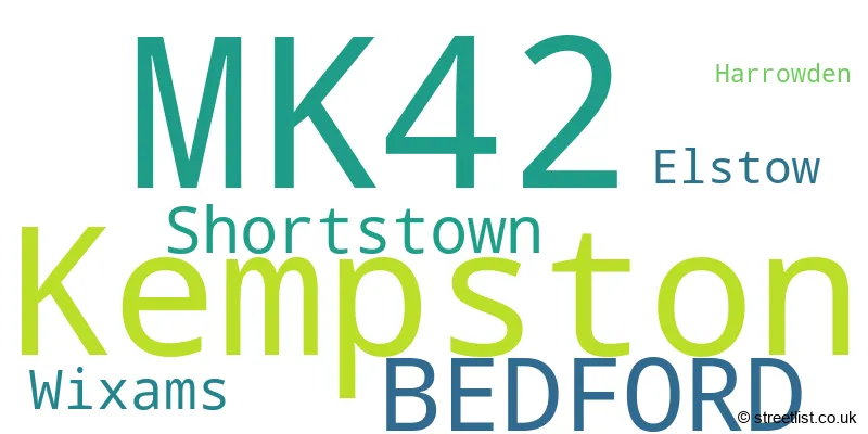
The largest settlement in the MK42 postal code is BEDFORD followed by Kempston, and Shortstown.
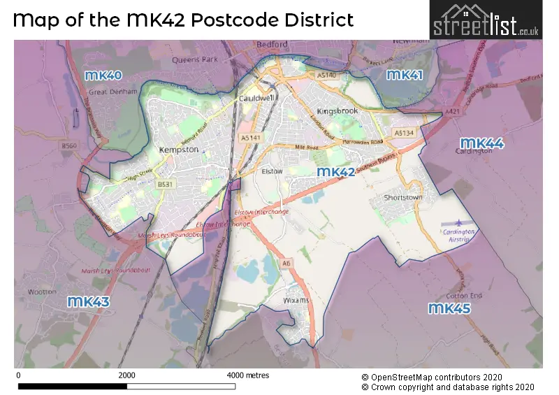
The MK42 Postcode shares a border with MK40 (BEDFORD, Great Denham, Biddenham), MK41 (BEDFORD, Clapham, Renhold), MK43 (Cranfield, Wootton, Marston Moretaine), MK44 (Sharnbrook, Great Barford, Riseley) and MK45 (Flitwick, Ampthill, Barton-le-Clay).
The primary settlement in the MK42 postcode district is Bedford, located in the county of Bedfordshire, England. Other significant settlements in the district include Harrowden, Shortstown, Wixams, Kempston, and Elstow. The most significant post town in the district is Bedford.
For the district MK42, we have data on 6 postcode sectors. Here's a breakdown: The sector MK42 0, covers Bedford and Shortstown in Bedfordshire. The sector MK42 5 is non-geographic. It's often designated for PO Boxes, large organisations, or special services. The sector MK42 6, covers Wixams in Bedfordshire. The sector MK42 7, covers Kempston in Bedfordshire. The sector MK42 8, covers Kempston in Bedfordshire. The sector MK42 9, covers Bedford and Elstow in Bedfordshire.

Map of the MK42 Postcode District
Explore the MK42 postcode district by using our free interactive map.
When it comes to local government, postal geography often disregards political borders. However, for a breakdown in the MK42 District: the district mostly encompasses the Bedford (B) area with a total of 1259 postcodes.
Recent House Sales in MK42
| Date | Price | Address |
|---|---|---|
| 09/10/2023 | £293,000 | Wilstead Road, Elstow, Bedford, MK42 9YQ |
| 06/10/2023 | £305,000 | Stuart Road, Kempston, Bedford, MK42 8HS |
| 28/09/2023 | £368,000 | Oliver Close, Kempston, Bedford, MK42 7FW |
| 22/09/2023 | £550,000 | Spring Road, Kempston, Bedford, MK42 8LR |
| 20/09/2023 | £410,000 | Ripon Close, Kempston, Bedford, MK42 8UZ |
| 14/09/2023 | £183,000 | Kingfisher Road, Wixams, Bedford, MK42 6AY |
| 12/09/2023 | £252,000 | Stafford Road, Bedford, MK42 9EA |
| 11/09/2023 | £535,000 | Crowsley Road, Kempston, Bedford, MK42 7FN |
| 08/09/2023 | £175,000 | Camford Court, Kempston, Bedford, MK42 7AH |
| 08/09/2023 | £290,000 | Teal Close, Wixams, Bedford, MK42 6AL |
Weather Forecast for MK42
Press Button to Show Forecast for Kempston
| Time Period | Icon | Description | Temperature | Rain Probability | Wind |
|---|---|---|---|---|---|
| 21:00 to 00:00 | Cloudy | 8.0°C (feels like 5.0°C) | 6.00% | ENE 7 mph |
Press Button to Show Forecast for Kempston
| Time Period | Icon | Description | Temperature | Rain Probability | Wind |
|---|---|---|---|---|---|
| 00:00 to 03:00 | Cloudy | 6.0°C (feels like 4.0°C) | 7.00% | ENE 7 mph | |
| 03:00 to 06:00 | Cloudy | 6.0°C (feels like 3.0°C) | 11.00% | NE 7 mph | |
| 06:00 to 09:00 | Cloudy | 6.0°C (feels like 3.0°C) | 49.00% | NE 7 mph | |
| 09:00 to 12:00 | Overcast | 7.0°C (feels like 4.0°C) | 49.00% | NE 11 mph | |
| 12:00 to 15:00 | Overcast | 9.0°C (feels like 6.0°C) | 14.00% | NE 11 mph | |
| 15:00 to 18:00 | Overcast | 10.0°C (feels like 7.0°C) | 14.00% | NE 11 mph | |
| 18:00 to 21:00 | Overcast | 9.0°C (feels like 6.0°C) | 20.00% | NE 11 mph | |
| 21:00 to 00:00 | Light rain | 8.0°C (feels like 5.0°C) | 83.00% | NNE 11 mph |
Press Button to Show Forecast for Kempston
| Time Period | Icon | Description | Temperature | Rain Probability | Wind |
|---|---|---|---|---|---|
| 00:00 to 03:00 | Heavy rain | 7.0°C (feels like 4.0°C) | 86.00% | NNE 13 mph | |
| 03:00 to 06:00 | Heavy rain | 7.0°C (feels like 4.0°C) | 91.00% | NNE 13 mph | |
| 06:00 to 09:00 | Heavy rain | 7.0°C (feels like 4.0°C) | 87.00% | N 11 mph | |
| 09:00 to 12:00 | Heavy rain | 8.0°C (feels like 5.0°C) | 82.00% | NW 11 mph | |
| 12:00 to 15:00 | Light rain | 8.0°C (feels like 5.0°C) | 52.00% | WNW 11 mph | |
| 15:00 to 18:00 | Cloudy | 10.0°C (feels like 7.0°C) | 14.00% | W 11 mph | |
| 18:00 to 21:00 | Cloudy | 10.0°C (feels like 8.0°C) | 8.00% | WSW 7 mph | |
| 21:00 to 00:00 | Partly cloudy (night) | 8.0°C (feels like 6.0°C) | 3.00% | SW 7 mph |
Press Button to Show Forecast for Kempston
| Time Period | Icon | Description | Temperature | Rain Probability | Wind |
|---|---|---|---|---|---|
| 00:00 to 03:00 | Partly cloudy (night) | 6.0°C (feels like 4.0°C) | 2.00% | SW 7 mph | |
| 03:00 to 06:00 | Clear night | 5.0°C (feels like 3.0°C) | 1.00% | SSW 7 mph | |
| 06:00 to 09:00 | Sunny day | 6.0°C (feels like 4.0°C) | 1.00% | S 7 mph | |
| 09:00 to 12:00 | Partly cloudy (day) | 11.0°C (feels like 9.0°C) | 2.00% | SSW 11 mph | |
| 12:00 to 15:00 | Partly cloudy (day) | 14.0°C (feels like 11.0°C) | 3.00% | S 11 mph | |
| 15:00 to 18:00 | Cloudy | 15.0°C (feels like 12.0°C) | 5.00% | S 11 mph | |
| 18:00 to 21:00 | Sunny day | 13.0°C (feels like 11.0°C) | 1.00% | S 9 mph | |
| 21:00 to 00:00 | Clear night | 9.0°C (feels like 7.0°C) | 1.00% | SSE 7 mph |
Press Button to Show Forecast for Kempston
| Time Period | Icon | Description | Temperature | Rain Probability | Wind |
|---|---|---|---|---|---|
| 00:00 to 03:00 | Clear night | 8.0°C (feels like 6.0°C) | 2.00% | SE 7 mph | |
| 03:00 to 06:00 | Clear night | 7.0°C (feels like 5.0°C) | 3.00% | SE 7 mph | |
| 06:00 to 09:00 | Sunny day | 9.0°C (feels like 7.0°C) | 3.00% | ESE 7 mph | |
| 09:00 to 12:00 | Partly cloudy (day) | 13.0°C (feels like 12.0°C) | 3.00% | ESE 9 mph | |
| 12:00 to 15:00 | Cloudy | 16.0°C (feels like 14.0°C) | 9.00% | SE 11 mph | |
| 15:00 to 18:00 | Cloudy | 16.0°C (feels like 15.0°C) | 9.00% | SE 9 mph | |
| 18:00 to 21:00 | Cloudy | 15.0°C (feels like 13.0°C) | 12.00% | ESE 9 mph | |
| 21:00 to 00:00 | Cloudy | 12.0°C (feels like 10.0°C) | 10.00% | ESE 7 mph |
Where is the MK42 Postcode District?
The postcode district for MK42 is situated in BEDFORD. This area is proximate to several nearby towns, including Shefford in the South East at a distance of approximately 6.95 miles, Sandy in the East about 8.06 miles away, Olney in the West at around 10.69 miles, St. Neots in the North East approximately 12.26 miles away, and Rushden in the North West at a distance of about 12.78 miles. Additionally, BEDFORD is located at a distance of approximately 44.28 miles from the center of London.
The district is within the post town of BEDFORD.
The sector has postcodes within the nation of England.
The MK42 Postcode District is in the Bedford region of Bedfordshire and Hertfordshire within the East of England.
| Postcode Sector | Delivery Office |
|---|---|
| MK42 0 | Bedford Mk42 Delivery Office |
| MK42 0 | Bedford Mk40-42 Delivery Office |
| MK42 1 | Bedford Mk40-42 Delivery Office |
| MK42 2 | Bedford Mk40-42 Delivery Office |
| MK42 3 | Bedford Mk40-42 Delivery Office |
| MK42 4 | Bedford Mk40-42 Delivery Office |
| MK42 5 | Bedford Mk40-42 Delivery Office |
| MK42 6 | Bedford Mk40-42 Delivery Office |
| MK42 7 | Bedford Mk40-42 Delivery Office |
| MK42 7 | Bedford Mk42 Delivery Office |
| MK42 8 | Bedford Mk40-42 Delivery Office |
| MK42 8 | Bedford Mk42 Delivery Office |
| MK42 9 | Bedford Mk40-42 Delivery Office |
| MK42 9 | Bedford Mk42 Delivery Office |
| M | K | 4 | 2 | - | X | X | X |
| M | K | 4 | 2 | Space | Numeric | Letter | Letter |
Current Monthly Rental Prices
| # Bedrooms | Min Price | Max Price | Avg Price |
|---|---|---|---|
| 1 | £625 | £2,340 | £1,095 |
| 2 | £875 | £1,200 | £1,035 |
| 3 | £1,300 | £1,550 | £1,443 |
| 4 | £1,600 | £1,950 | £1,775 |
Current House Prices
| # Bedrooms | Min Price | Max Price | Avg Price |
|---|---|---|---|
| £20,000 | £100,000 | £71,667 | |
| 1 | £37,500 | £280,000 | £151,771 |
| 2 | £52,500 | £360,000 | £228,778 |
| 3 | £185,000 | £455,000 | £328,355 |
| 4 | £230,000 | £795,000 | £452,892 |
| 5 | £300,000 | £726,995 | £545,124 |
| 6 | £674,950 | £835,000 | £754,975 |
Estate Agents who Operate in the MK42 District
| Logo | Name | Brand Name | Address | Contact Number | Total Properties |
|---|---|---|---|---|---|
 | Bedford | Waldens Estate Agents | 188-190 Bedford Road, Bedford, MK42 8BL | 020 3835 4277 | 31 |
 | Kempston | Goodacres Residential | 3 High Street, Kempston, Bedford, MK42 7BT | 01234 860680 | 23 |
 | Bedford | Connells | 42 Allhallows, Bedford, MK40 1LN | 020 3869 5634 | 21 |
 | Bedford | Cooper Wallace | 11 Goldington Road, Bedford, MK40 3JY | 01234 860634 | 20 |
 | Bedford | Taylor Made | Taylor House, Roman Gate, Saxon Way, Great Denham, Bedford, MK40 4FU | 01234 608741 | 20 |
| Type of Property | 2018 Average | 2018 Sales | 2017 Average | 2017 Sales | 2016 Average | 2016 Sales | 2015 Average | 2015 Sales |
|---|---|---|---|---|---|---|---|---|
| Detached | £354,795 | 157 | £342,478 | 185 | £325,536 | 188 | £308,908 | 241 |
| Semi-Detached | £261,918 | 252 | £261,631 | 317 | £235,838 | 299 | £206,756 | 314 |
| Terraced | £237,130 | 273 | £224,035 | 317 | £208,807 | 367 | £188,402 | 387 |
| Flats | £165,216 | 153 | £162,102 | 180 | £142,294 | 193 | £133,781 | 159 |