The LE18 postcode district is a postal district located in the LE Leicester postcode area with a population of 33,755 residents according to the 2021 England and Wales Census.
The area of the LE18 postcode district is 6.11 square miles which is 15.82 square kilometres or 3,909.93 acres.
Currently, the LE18 district has about 742 postcode units spread across 4 geographic postcode sectors.
Given that each sector allows for 400 unique postcode combinations, the district has a capacity of 1,600 postcodes. With 742 postcodes already in use, this leaves 858 units available.
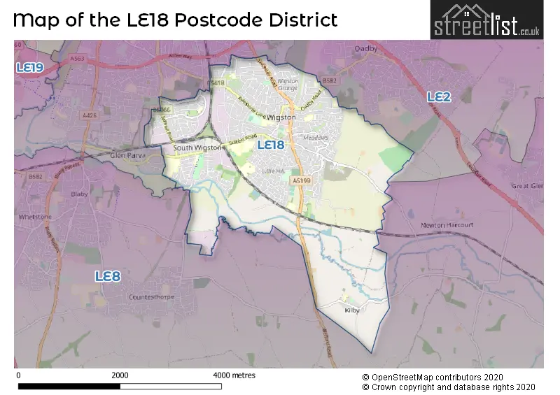
The LE18 postal code covers the settlement of WIGSTON.
The LE18 Postcode shares a border with LE2 (LEICESTER, Oadby, Glen Parva) and LE8 (Blaby, Countesthorpe, Whetstone).
The primary settlement in the LE18 postcode district is Wigston in the county of Leicestershire. Additionally, the Kilby settlement is also present in the district. The post town for this postcode district is Wigston.
For the district LE18, we have data on 5 postcode sectors. Here's a breakdown: The sector LE18 1, covers Wigston in Leicestershire. The sector LE18 2, covers Wigston in Leicestershire. The sector LE18 3, covers Wigston in Leicestershire. The sector LE18 4, covers Wigston in Leicestershire. The sector LE18 9 is non-geographic. It's often designated for PO Boxes, large organisations, or special services.


Map of the LE18 Postcode District
Explore the LE18 postcode district by using our free interactive map.
When it comes to local government, postal geography often disregards political borders. However, for a breakdown in the LE18 District: the district mostly encompasses the Oadby and Wigston District (B) (747 postcodes), and finally, the Blaby District area (9 postcodes).
Recent House Sales in LE18
| Date | Price | Address |
|---|---|---|
| 13/10/2023 | £250,300 | Waterloo Crescent, Wigston, LE18 3QJ |
| 06/10/2023 | £191,000 | Simons Close, Wigston, LE18 3UD |
| 29/09/2023 | £293,000 | Tythorn Drive, Wigston, LE18 1BS |
| 01/09/2023 | £300,000 | St Ives Road, Wigston, LE18 2JA |
| 31/08/2023 | £1,330,000 | Chartwell Point, Wigston, LE18 2FT |
| 30/08/2023 | £105,000 | Jasmine Court, Wigston, LE18 4TR |
| 30/08/2023 | £295,000 | Leicester Road, Wigston, LE18 1DS |
| 25/08/2023 | £215,000 | Westfield Avenue, Wigston, LE18 1HY |
| 25/08/2023 | £258,000 | Hoskins Close, Wigston, LE18 3TQ |
| 25/08/2023 | £206,000 | Burleigh Avenue, Wigston, LE18 1FN |
Weather Forecast for LE18
Press Button to Show Forecast for Wigston
| Time Period | Icon | Description | Temperature | Rain Probability | Wind |
|---|---|---|---|---|---|
| 06:00 to 09:00 | Cloudy | 5.0°C (feels like 2.0°C) | 10.00% | NE 7 mph | |
| 09:00 to 12:00 | Cloudy | 7.0°C (feels like 4.0°C) | 53.00% | ENE 9 mph | |
| 12:00 to 15:00 | Overcast | 8.0°C (feels like 5.0°C) | 15.00% | ENE 11 mph | |
| 15:00 to 18:00 | Overcast | 8.0°C (feels like 5.0°C) | 16.00% | NE 11 mph | |
| 18:00 to 21:00 | Overcast | 7.0°C (feels like 4.0°C) | 13.00% | NE 11 mph | |
| 21:00 to 00:00 | Overcast | 6.0°C (feels like 3.0°C) | 12.00% | NE 11 mph |
Press Button to Show Forecast for Wigston
| Time Period | Icon | Description | Temperature | Rain Probability | Wind |
|---|---|---|---|---|---|
| 00:00 to 03:00 | Overcast | 6.0°C (feels like 2.0°C) | 21.00% | NNE 11 mph | |
| 03:00 to 06:00 | Light rain | 6.0°C (feels like 2.0°C) | 58.00% | N 13 mph | |
| 06:00 to 09:00 | Heavy rain | 6.0°C (feels like 2.0°C) | 85.00% | N 13 mph | |
| 09:00 to 12:00 | Heavy rain | 6.0°C (feels like 3.0°C) | 81.00% | NNW 11 mph | |
| 12:00 to 15:00 | Light rain | 8.0°C (feels like 5.0°C) | 57.00% | NW 11 mph | |
| 15:00 to 18:00 | Light rain | 9.0°C (feels like 7.0°C) | 48.00% | WNW 9 mph | |
| 18:00 to 21:00 | Cloudy | 9.0°C (feels like 7.0°C) | 10.00% | W 7 mph | |
| 21:00 to 00:00 | Partly cloudy (night) | 7.0°C (feels like 5.0°C) | 3.00% | SW 7 mph |
Press Button to Show Forecast for Wigston
| Time Period | Icon | Description | Temperature | Rain Probability | Wind |
|---|---|---|---|---|---|
| 00:00 to 03:00 | Clear night | 5.0°C (feels like 3.0°C) | 1.00% | SW 7 mph | |
| 03:00 to 06:00 | Clear night | 4.0°C (feels like 1.0°C) | 1.00% | SSW 7 mph | |
| 06:00 to 09:00 | Sunny day | 5.0°C (feels like 2.0°C) | 1.00% | S 7 mph | |
| 09:00 to 12:00 | Partly cloudy (day) | 10.0°C (feels like 8.0°C) | 1.00% | S 11 mph | |
| 12:00 to 15:00 | Cloudy | 13.0°C (feels like 10.0°C) | 6.00% | S 13 mph | |
| 15:00 to 18:00 | Cloudy | 13.0°C (feels like 11.0°C) | 7.00% | S 13 mph | |
| 18:00 to 21:00 | Sunny day | 12.0°C (feels like 10.0°C) | 2.00% | S 11 mph | |
| 21:00 to 00:00 | Clear night | 9.0°C (feels like 6.0°C) | 2.00% | SSE 9 mph |
Press Button to Show Forecast for Wigston
| Time Period | Icon | Description | Temperature | Rain Probability | Wind |
|---|---|---|---|---|---|
| 00:00 to 03:00 | Clear night | 7.0°C (feels like 5.0°C) | 3.00% | SE 9 mph | |
| 03:00 to 06:00 | Clear night | 6.0°C (feels like 4.0°C) | 3.00% | SE 9 mph | |
| 06:00 to 09:00 | Sunny day | 8.0°C (feels like 5.0°C) | 4.00% | ESE 9 mph | |
| 09:00 to 12:00 | Cloudy | 12.0°C (feels like 10.0°C) | 7.00% | ESE 11 mph | |
| 12:00 to 15:00 | Partly cloudy (day) | 15.0°C (feels like 13.0°C) | 6.00% | SE 11 mph | |
| 15:00 to 18:00 | Cloudy | 15.0°C (feels like 13.0°C) | 11.00% | SE 11 mph | |
| 18:00 to 21:00 | Cloudy | 14.0°C (feels like 12.0°C) | 9.00% | ESE 9 mph | |
| 21:00 to 00:00 | Cloudy | 11.0°C (feels like 9.0°C) | 10.00% | ESE 9 mph |
Where is the LE18 Postcode District?
The postcode district for LE18 is located in Wigston. Wigston is a town near several other towns in different directions. To the north, there is Leicester, which is approximately 3.64 miles away. To the south-west, there is Lutterworth, which is approximately 8.99 miles away. To the south-east, there is Market Harborough, which is approximately 10.63 miles away. To the north-west, there is Markfield, which is approximately 11.18 miles away. To the west, there is Hinckley, which is approximately 11.37 miles away. Additionally, the distance from Wigston to the centre of London is approximately 84.77 miles.
The district is within the post town of WIGSTON.
The sector has postcodes within the nation of England.
The LE18 Postcode District is in the Leicestershire CC and Rutland region of Leicestershire, Rutland and Northamptonshire within the East Midlands (England).
| Postcode Sector | Delivery Office |
|---|---|
| LE18 1 | Wigston Delivery Office |
| LE18 2 | Wigston Delivery Office |
| LE18 3 | Wigston Delivery Office |
| LE18 4 | Wigston Delivery Office |
| L | E | 1 | 8 | - | X | X | X |
| L | E | 1 | 8 | Space | Numeric | Letter | Letter |
Tourist Attractions within the Postcode Area
We found 1 visitor attractions within the LE18 postcode area
| Wigston Framework Knitters Museum |
|---|
| Museums & Art Galleries |
| Museum and / or Art Gallery |
| View Wigston Framework Knitters Museum on Google Maps |
Current Monthly Rental Prices
| # Bedrooms | Min Price | Max Price | Avg Price |
|---|---|---|---|
| £600 | £600 | £600 | |
| 1 | £675 | £725 | £700 |
| 2 | £675 | £900 | £811 |
| 3 | £650 | £1,400 | £1,136 |
| 4 | £1,300 | £1,500 | £1,433 |
Current House Prices
| # Bedrooms | Min Price | Max Price | Avg Price |
|---|---|---|---|
| £275,000 | £600,000 | £437,500 | |
| 1 | £99,000 | £99,000 | £99,000 |
| 2 | £100,000 | £350,000 | £208,627 |
| 3 | £165,000 | £500,000 | £283,702 |
| 4 | £220,000 | £530,000 | £400,178 |
| 5 | £300,000 | £750,000 | £489,166 |
| 6 | £404,995 | £480,000 | £454,998 |
| 17 | £2,000,000 | £2,000,000 | £2,000,000 |
| 30 | £2,250,000 | £2,250,000 | £2,250,000 |
Estate Agents who Operate in the LE18 District
| Logo | Name | Brand Name | Address | Contact Number | Total Properties |
|---|---|---|---|---|---|
 | Wigston | Hunters | 44 Blaby Road Wigston LE18 4SD | 0116 366 0660 | 50 |
 | Wigston | Spencers Estate Agency | 80 Leicester Road, Wigston, Leicestershire, LE18 1DR | 0116 216 2760 | 35 |
 | Leicester | Phillips George Estate Agents | 46 Long Street, Wigston, LE18 2AH | 0116 366 5752 | 23 |
 | Wigston | Nest Estate Agents | 13 Leicester Road, Wigston, Leicester LE18 1NR | 0116 216 5407 | 19 |
 | Wigston | Knightsbridge Estate Agents & Valuers | 34 Leicester Road, Wigston, LE18 1DR | 0116 216 3876 | 17 |
| Type of Property | 2018 Average | 2018 Sales | 2017 Average | 2017 Sales | 2016 Average | 2016 Sales | 2015 Average | 2015 Sales |
|---|---|---|---|---|---|---|---|---|
| Detached | £290,946 | 86 | £289,927 | 80 | £245,027 | 154 | £228,985 | 127 |
| Semi-Detached | £197,122 | 292 | £183,142 | 265 | £169,930 | 271 | £156,999 | 295 |
| Terraced | £150,337 | 142 | £146,968 | 158 | £137,642 | 178 | £126,829 | 171 |
| Flats | £109,442 | 19 | £98,816 | 19 | £90,170 | 32 | £81,877 | 13 |