The CV12 postcode district is a postal district located in the CV Coventry postcode area with a population of 32,098 residents according to the 2021 England and Wales Census.
The area of the CV12 postcode district is 9.69 square miles which is 25.11 square kilometres or 6,203.59 acres.
Currently, the CV12 district has about 633 postcode units spread across 3 geographic postcode sectors.
Given that each sector allows for 400 unique postcode combinations, the district has a capacity of 1,200 postcodes. With 633 postcodes already in use, this leaves 567 units available.
The largest settlements in the CV12 postal code are BEDWORTH and Bulkington.
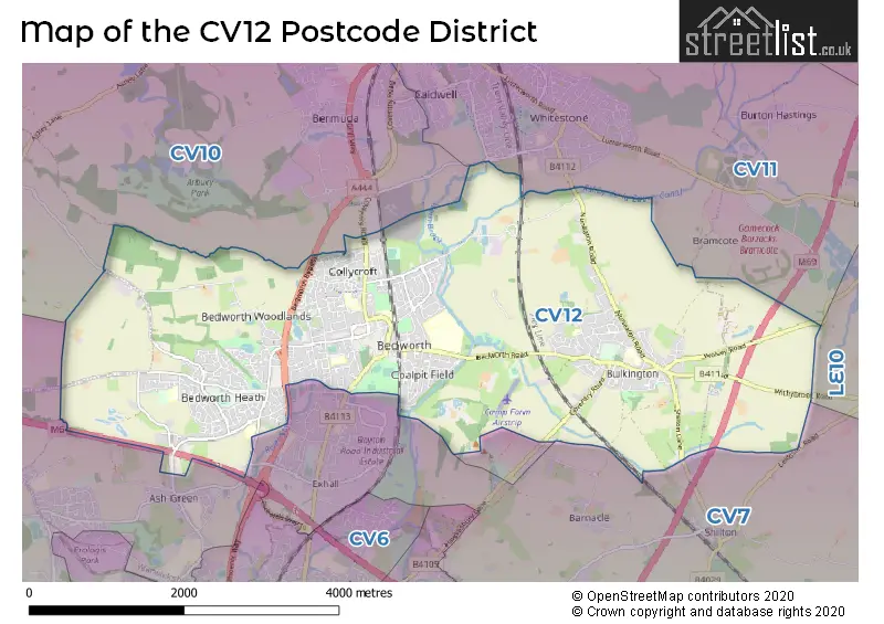
The CV12 Postcode shares a border with CV10 (NUNEATON, Hartshill, Galley Common), CV11 (NUNEATON, Attleborough Fields Ind Estate, Bramcote) and CV7 (Balsall Common, Exhall, Meriden).
The primary settlement in the CV12 postcode district is Bedworth, located in Warwickshire, England. The other significant settlements in this district include Bulkington and Marston Jabbett, also located in Warwickshire. The most significant post town in this district is Bedworth.
For the district CV12, we have data on 4 postcode sectors. Here's a breakdown: The sector CV12 0, covers Bedworth in Warwickshire. The sector CV12 2 is non-geographic. It's often designated for PO Boxes, large organisations, or special services. The sector CV12 8, covers Bedworth in Warwickshire. The sector CV12 9, covers Bulkington and Bedworth in Warwickshire.

Map of the CV12 Postcode District
Explore the CV12 postcode district by using our free interactive map.
When it comes to local government, postal geography often disregards political borders. However, for a breakdown in the CV12 District: the district mostly encompasses the Nuneaton and Bedworth District (B) area with a total of 642 postcodes.
Weather Forecast for CV12
Press Button to Show Forecast for Bedworth
| Time Period | Icon | Description | Temperature | Rain Probability | Wind |
|---|---|---|---|---|---|
| 12:00 to 15:00 | Light rain | 8.0°C (feels like 5.0°C) | 45.00% | ENE 11 mph | |
| 15:00 to 18:00 | Overcast | 8.0°C (feels like 5.0°C) | 14.00% | NE 11 mph | |
| 18:00 to 21:00 | Overcast | 8.0°C (feels like 4.0°C) | 15.00% | NE 11 mph | |
| 21:00 to 00:00 | Overcast | 6.0°C (feels like 3.0°C) | 12.00% | NE 11 mph |
Press Button to Show Forecast for Bedworth
| Time Period | Icon | Description | Temperature | Rain Probability | Wind |
|---|---|---|---|---|---|
| 00:00 to 03:00 | Overcast | 6.0°C (feels like 2.0°C) | 18.00% | NNE 11 mph | |
| 03:00 to 06:00 | Light rain | 5.0°C (feels like 2.0°C) | 56.00% | N 13 mph | |
| 06:00 to 09:00 | Heavy rain | 5.0°C (feels like 2.0°C) | 80.00% | N 13 mph | |
| 09:00 to 12:00 | Heavy rain | 6.0°C (feels like 3.0°C) | 80.00% | NNW 11 mph | |
| 12:00 to 15:00 | Light rain | 8.0°C (feels like 5.0°C) | 53.00% | NW 11 mph | |
| 15:00 to 18:00 | Cloudy | 10.0°C (feels like 8.0°C) | 14.00% | WNW 9 mph | |
| 18:00 to 21:00 | Cloudy | 10.0°C (feels like 8.0°C) | 9.00% | W 7 mph | |
| 21:00 to 00:00 | Clear night | 7.0°C (feels like 5.0°C) | 2.00% | SW 7 mph |
Press Button to Show Forecast for Bedworth
| Time Period | Icon | Description | Temperature | Rain Probability | Wind |
|---|---|---|---|---|---|
| 00:00 to 03:00 | Clear night | 6.0°C (feels like 3.0°C) | 1.00% | SW 7 mph | |
| 03:00 to 06:00 | Clear night | 4.0°C (feels like 2.0°C) | 1.00% | SSW 7 mph | |
| 06:00 to 09:00 | Sunny day | 5.0°C (feels like 2.0°C) | 1.00% | S 7 mph | |
| 09:00 to 12:00 | Sunny day | 10.0°C (feels like 8.0°C) | 1.00% | S 11 mph | |
| 12:00 to 15:00 | Overcast | 13.0°C (feels like 10.0°C) | 11.00% | S 13 mph | |
| 15:00 to 18:00 | Cloudy | 14.0°C (feels like 11.0°C) | 6.00% | S 13 mph | |
| 18:00 to 21:00 | Partly cloudy (day) | 13.0°C (feels like 10.0°C) | 3.00% | S 11 mph | |
| 21:00 to 00:00 | Clear night | 9.0°C (feels like 7.0°C) | 3.00% | SSE 9 mph |
Press Button to Show Forecast for Bedworth
| Time Period | Icon | Description | Temperature | Rain Probability | Wind |
|---|---|---|---|---|---|
| 00:00 to 03:00 | Clear night | 8.0°C (feels like 5.0°C) | 3.00% | SE 9 mph | |
| 03:00 to 06:00 | Clear night | 7.0°C (feels like 4.0°C) | 2.00% | SE 9 mph | |
| 06:00 to 09:00 | Sunny day | 8.0°C (feels like 5.0°C) | 4.00% | ESE 9 mph | |
| 09:00 to 12:00 | Sunny day | 12.0°C (feels like 10.0°C) | 5.00% | ESE 11 mph | |
| 12:00 to 15:00 | Partly cloudy (day) | 15.0°C (feels like 12.0°C) | 9.00% | SE 13 mph | |
| 15:00 to 18:00 | Partly cloudy (day) | 16.0°C (feels like 13.0°C) | 8.00% | SE 11 mph | |
| 18:00 to 21:00 | Cloudy | 15.0°C (feels like 13.0°C) | 9.00% | ESE 9 mph | |
| 21:00 to 00:00 | Partly cloudy (night) | 11.0°C (feels like 10.0°C) | 6.00% | ESE 7 mph |
Where is the CV12 Postcode District?
The CV12 postcode district is located in Bedworth, near several towns. To the North, there is Nuneaton which is approximately 3.41 miles away. To the South West, Coventry is about 4.81 miles away. Hinckley is situated to the North East at a distance of 5.42 miles. Atherstone is located to the North West, around 8.18 miles away. Lutterworth is to the East, approximately 10.44 miles away. Rugby is situated to the South East, approximately 10.49 miles away. Finally, Leamington Spa is located to the South at a distance of 13.70 miles. The CV12 postcode district is about 88.02 miles away from the centre of London.
The district is within the post town of BEDWORTH.
The sector has postcodes within the nation of England.
The CV12 Postcode District is covers the following regions.
- Warwickshire - Herefordshire, Worcestershire and Warwickshire - West Midlands (England)
- Coventry - West Midlands - West Midlands (England)
| Postcode Sector | Delivery Office |
|---|---|
| CV12 0 | Bedworth Delivery Office |
| CV12 8 | Bedworth Delivery Office |
| CV12 9 | Bedworth Delivery Office |
| C | V | 1 | 2 | - | X | X | X |
| C | V | 1 | 2 | Space | Numeric | Letter | Letter |
Current Monthly Rental Prices
| # Bedrooms | Min Price | Max Price | Avg Price |
|---|---|---|---|
| 1 | £750 | £750 | £750 |
| 2 | £725 | £950 | £870 |
| 3 | £925 | £995 | £960 |
Current House Prices
| # Bedrooms | Min Price | Max Price | Avg Price |
|---|---|---|---|
| £1,200,000 | £1,200,000 | £1,200,000 | |
| 1 | £60,000 | £240,000 | £111,097 |
| 2 | £82,000 | £425,000 | £222,578 |
| 3 | £120,000 | £675,000 | £271,514 |
| 4 | £210,000 | £900,000 | £384,018 |
| 5 | £325,000 | £365,000 | £350,000 |
| 6 | £325,000 | £460,000 | £411,667 |
Estate Agents who Operate in the CV12 District
| Logo | Name | Brand Name | Address | Contact Number | Total Properties |
|---|---|---|---|---|---|
 | Bedworth | Reeds Rains | 52/54 King Street, Bedworth, CV12 8JQ | 024 7542 9600 | 33 |
 | Nuneaton | Alan Cooper Estates | 22 Newdegate Street Nuneaton CV11 4EU | 024 7634 9336 | 24 |
 | Bedworth | Your Move | 5 King Street, Bedworth, CV12 8HS | 024 7542 2572 | 21 |
 | Bedworth | Sheldon Bosley Knight | 13 King Street, Bedworth, CV12 8HS | 024 7631 2379 | 18 |
 | Nuneaton | Carters Estate Agents | 66 St Nicolas Park Drive Nuneaton Warwickshire CV11 6DJ | 024 7542 7931 | 16 |
| Type of Property | 2018 Average | 2018 Sales | 2017 Average | 2017 Sales | 2016 Average | 2016 Sales | 2015 Average | 2015 Sales |
|---|---|---|---|---|---|---|---|---|
| Detached | £268,931 | 115 | £260,717 | 92 | £249,360 | 96 | £229,668 | 108 |
| Semi-Detached | £179,313 | 233 | £162,938 | 245 | £151,904 | 242 | £139,888 | 234 |
| Terraced | £139,517 | 122 | £132,128 | 123 | £124,174 | 135 | £121,440 | 129 |
| Flats | £101,517 | 42 | £104,817 | 41 | £105,072 | 38 | £95,848 | 33 |