The S36 postcode district is a postal district located in the S Sheffield postcode area with a population of 29,000 residents according to the 2021 England and Wales Census.
The area of the S36 postcode district is 54.48 square miles which is 141.11 square kilometres or 34,870.24 acres.
Currently, the S36 district has about 732 postcode units spread across 8 geographic postcode sectors.
Given that each sector allows for 400 unique postcode combinations, the district has a capacity of 3,200 postcodes. With 732 postcodes already in use, this leaves 2468 units available.
The largest settlement in the S36 postal code is Penistone followed by Stocksbridge, and Deepcar.
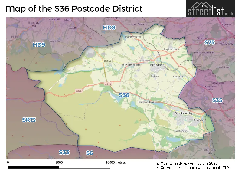
The S36 Postcode shares a border with S35 (Chapeltown, High Green, Ecclesfield), S75 (BARNSLEY, Darton, Dodworth), HD8 (Kirkburton, Skelmanthorpe, Lepton), S6 (SHEFFIELD, Stannington, Loxley), HD9 (HOLMFIRTH, Meltham, Honley) and SK13 (GLOSSOP, Hadfield, Tintwistle).
The primary settlement in the S36 postcode district is Deepcar, located in South Yorkshire, England. Other significant settlements include Stocksbridge, Bolsterstone, Crow Edge, Dunford Bridge, Midhopestones, Penistone, Hoylandswaine, Thurlstone, Oxspring, Millhouse Green, and Sheffield. The most significant post town in this district is Sheffield.
For the district S36, we have data on 9 postcode sectors. Here's a breakdown: The sector S36 0 is non-geographic. It's often designated for PO Boxes, large organisations, or special services. The sector S36 1, covers Stocksbridge in South Yorkshire. The sector S36 2, covers Deepcar and Stocksbridge in South Yorkshire. The sector S36 3, covers Bolsterstone in South Yorkshire. The sector S36 4, covers Crow Edge and Stocksbridge and Dunford Bridge and Midhopestones and Bolsterstone in South Yorkshire. The sector S36 6, covers Penistone in South Yorkshire. The sector S36 7, covers Hoylandswaine and Penistone in South Yorkshire. The sector S36 8, covers Oxspring and Penistone in South Yorkshire. The sector S36 9, covers Thurlstone and Millhouse Green and Penistone in South Yorkshire.

Map of the S36 Postcode District
Explore the S36 postcode district by using our free interactive map.
When it comes to local government, postal geography often disregards political borders. However, for a breakdown in the S36 District: the district mostly encompasses the Barnsley District (B) (429 postcodes), and finally, the Sheffield District (B) area (317 postcodes).
Recent House Sales in S36
| Date | Price | Address |
|---|---|---|
| 12/10/2023 | £90,500 | Howson Road, Deepcar, Sheffield, S36 2QS |
| 05/10/2023 | £160,000 | Park Avenue, Penistone, Sheffield, S36 6DN |
| 29/09/2023 | £114,000 | Sheffield Road, Penistone, Sheffield, S36 6HE |
| 29/09/2023 | £137,000 | Haywood Avenue, Deepcar, Sheffield, S36 2QD |
| 28/09/2023 | £325,000 | Ward Street, Penistone, Sheffield, S36 6EP |
| 26/09/2023 | £197,500 | Tennyson Close, Penistone, Sheffield, S36 6GY |
| 22/09/2023 | £246,000 | Green Road, Penistone, Sheffield, S36 6BE |
| 22/09/2023 | £332,000 | Haywood Lane, Deepcar, Sheffield, S36 2QF |
| 14/09/2023 | £240,000 | New Chapel Road, Penistone, Sheffield, S36 9AG |
| 13/09/2023 | £260,000 | Cotefield Place, Penistone, Sheffield, S36 6FD |
Weather Forecast for S36
Press Button to Show Forecast for Langsett Youth Hostel
| Time Period | Icon | Description | Temperature | Rain Probability | Wind |
|---|---|---|---|---|---|
| 00:00 to 03:00 | Partly cloudy (night) | 1.0°C (feels like 0.0°C) | 1.00% | NE 2 mph | |
| 03:00 to 06:00 | Clear night | 0.0°C (feels like -2.0°C) | 1.00% | N 2 mph | |
| 06:00 to 09:00 | Sunny day | 1.0°C (feels like 0.0°C) | 1.00% | N 2 mph | |
| 09:00 to 12:00 | Overcast | 4.0°C (feels like 2.0°C) | 8.00% | E 4 mph | |
| 12:00 to 15:00 | Overcast | 6.0°C (feels like 5.0°C) | 10.00% | ENE 7 mph | |
| 15:00 to 18:00 | Cloudy | 7.0°C (feels like 6.0°C) | 9.00% | ENE 4 mph | |
| 18:00 to 21:00 | Cloudy | 6.0°C (feels like 4.0°C) | 5.00% | E 7 mph | |
| 21:00 to 00:00 | Cloudy | 3.0°C (feels like 1.0°C) | 8.00% | E 4 mph |
Press Button to Show Forecast for Langsett Youth Hostel
| Time Period | Icon | Description | Temperature | Rain Probability | Wind |
|---|---|---|---|---|---|
| 00:00 to 03:00 | Cloudy | 2.0°C (feels like 1.0°C) | 7.00% | ESE 4 mph | |
| 03:00 to 06:00 | Cloudy | 2.0°C (feels like 0.0°C) | 9.00% | ENE 4 mph | |
| 06:00 to 09:00 | Cloudy | 3.0°C (feels like 1.0°C) | 12.00% | ENE 4 mph | |
| 09:00 to 12:00 | Cloudy | 6.0°C (feels like 3.0°C) | 10.00% | E 9 mph | |
| 12:00 to 15:00 | Overcast | 7.0°C (feels like 5.0°C) | 17.00% | E 9 mph | |
| 15:00 to 18:00 | Overcast | 8.0°C (feels like 5.0°C) | 21.00% | E 11 mph | |
| 18:00 to 21:00 | Cloudy | 7.0°C (feels like 4.0°C) | 16.00% | ENE 11 mph | |
| 21:00 to 00:00 | Cloudy | 4.0°C (feels like 1.0°C) | 17.00% | ENE 9 mph |
Press Button to Show Forecast for Langsett Youth Hostel
| Time Period | Icon | Description | Temperature | Rain Probability | Wind |
|---|---|---|---|---|---|
| 00:00 to 03:00 | Light rain | 4.0°C (feels like 0.0°C) | 47.00% | NE 9 mph | |
| 03:00 to 06:00 | Light rain | 4.0°C (feels like 0.0°C) | 47.00% | NNE 11 mph | |
| 06:00 to 09:00 | Heavy rain | 5.0°C (feels like 1.0°C) | 74.00% | NNE 11 mph | |
| 09:00 to 12:00 | Heavy rain | 6.0°C (feels like 2.0°C) | 77.00% | NNE 11 mph | |
| 12:00 to 15:00 | Heavy rain | 7.0°C (feels like 4.0°C) | 78.00% | NNE 11 mph | |
| 15:00 to 18:00 | Light rain | 7.0°C (feels like 4.0°C) | 56.00% | NNW 11 mph | |
| 18:00 to 21:00 | Light rain shower (day) | 7.0°C (feels like 5.0°C) | 36.00% | N 9 mph | |
| 21:00 to 00:00 | Partly cloudy (night) | 6.0°C (feels like 3.0°C) | 10.00% | NW 7 mph |
Where is the S36 Postcode District?
The postcode district S36 is located in Sheffield, a town in South Yorkshire. It is nearby several other towns including Holmfirth, Barnsley, Mirfield, Glossop, and Wakefield. Additionally, the distance from Sheffield to the centre of London is approximately 152.33 miles.
The district is within the post town of SHEFFIELD.
The sector has postcodes within the nation of England.
The S36 Postcode District is covers the following regions.
- Sheffield - South Yorkshire - Yorkshire and The Humber
- Barnsley, Doncaster and Rotherham - South Yorkshire - Yorkshire and The Humber
| Postcode Sector | Delivery Office |
|---|---|
| S36 1 | Stocksbridge Delivery Office |
| S36 2 | Stocksbridge Delivery Office |
| S36 3 | Stocksbridge Delivery Office |
| S36 4 | Stocksbridge Delivery Office |
| S36 6 | Penistone Scale Payment Delivery Office |
| S36 7 | Penistone Scale Payment Delivery Office |
| S36 8 | Penistone Scale Payment Delivery Office |
| S36 9 | Penistone Scale Payment Delivery Office |
| S | 3 | 6 | - | X | X | X |
| S | 3 | 6 | Space | Numeric | Letter | Letter |
Current Monthly Rental Prices
| # Bedrooms | Min Price | Max Price | Avg Price |
|---|---|---|---|
| 1 | £400 | £520 | £448 |
| 2 | £625 | £750 | £683 |
| 3 | £895 | £895 | £895 |
Current House Prices
| # Bedrooms | Min Price | Max Price | Avg Price |
|---|---|---|---|
| £295,000 | £550,000 | £422,500 | |
| 1 | £65,000 | £155,000 | £126,250 |
| 2 | £99,000 | £625,000 | £204,952 |
| 3 | £115,000 | £500,000 | £248,655 |
| 4 | £249,950 | £850,000 | £449,059 |
| 5 | £335,000 | £1,250,000 | £666,529 |
| 6 | £525,000 | £675,000 | £583,333 |
| 7 | £1,200,000 | £1,200,000 | £1,200,000 |
Estate Agents who Operate in the S36 District
| Logo | Name | Brand Name | Address | Contact Number | Total Properties |
|---|---|---|---|---|---|
 | Penistone | Mallinson and Co | Suite 9, Penistone 1, St. Marys Street Penistone, S36 6DT | 01226 414150 | 20 |
 | Stocksbridge | Saxton Mee | 462 Manchester Road, Stocksbridge, S36 2DU | 0114 697 4889 | 15 |
 | Penistone | Butcher Residential Ltd | 2 Crown House Shrewsbury Road, Penistone, S36 6DY | 01226 664686 | 14 |
 | Penistone | Simon Blyth | 1a St. Marys Street Penistone S36 6DT | 01226 447683 | 13 |
 | Sheffield | Simon Blyth | Unit 1 Brearley House, Fox Valley, Stocksbridge, Sheffield, S36 2AB | 0114 321 6590 | 13 |
| Type of Property | 2018 Average | 2018 Sales | 2017 Average | 2017 Sales | 2016 Average | 2016 Sales | 2015 Average | 2015 Sales |
|---|---|---|---|---|---|---|---|---|
| Detached | £304,018 | 224 | £286,629 | 253 | £256,371 | 236 | £260,879 | 164 |
| Semi-Detached | £158,253 | 199 | £150,307 | 197 | £136,073 | 182 | £139,084 | 128 |
| Terraced | £139,279 | 150 | £130,156 | 220 | £130,004 | 180 | £138,404 | 154 |
| Flats | £98,021 | 21 | £100,858 | 26 | £108,195 | 37 | £113,718 | 30 |