The HD9 postcode district is a postal district located in the HD Huddersfield postcode area with a population of 35,884 residents according to the 2021 England and Wales Census.
The area of the HD9 postcode district is 37.43 square miles which is 96.93 square kilometres or 23,952.49 acres.
Currently, the HD9 district has about 1182 postcode units spread across 7 geographic postcode sectors.
Given that each sector allows for 400 unique postcode combinations, the district has a capacity of 2,800 postcodes. With 1182 postcodes already in use, this leaves 1618 units available.
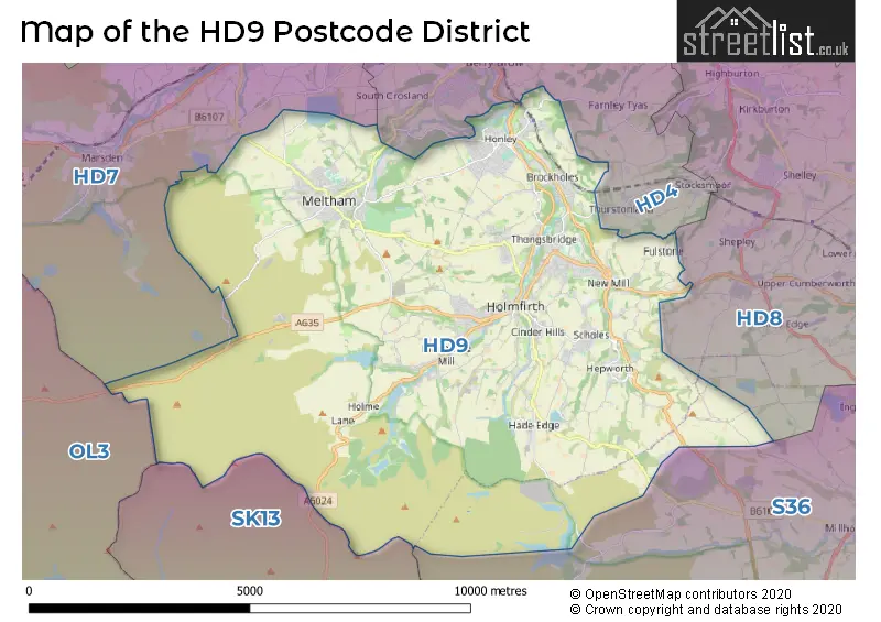
The largest settlement in the HD9 postal code is HOLMFIRTH followed by Meltham, and Honley.
The HD9 Postcode shares a border with S36 (Penistone, Stocksbridge, Deepcar), HD8 (Kirkburton, Skelmanthorpe, Lepton), HD4 (HUDDERSFIELD, Netherton, Newsome), HD7 (Golcar, Slaithwaite, Marsden), SK13 (GLOSSOP, Hadfield, Tintwistle) and OL3 (Greenfield, Uppermill, Delph).
The primary settlement in the HD9 postcode district is Holmfirth, located in the county of West Yorkshire. Other significant settlements in the district include Meltham and Honley, also within West Yorkshire. The most significant post town in the district is Holmfirth.
For the district HD9, we have data on 8 postcode sectors. Here's a breakdown: The sector HD9 1, covers Holmfirth and Scholes and Hepworth and New Mill in West Yorkshire. The sector HD9 2, covers Holmfirth and Holmbridge in West Yorkshire. The sector HD9 3, covers Holmfirth and Netherthong and Upperthong and Thongsbridge in West Yorkshire. The sector HD9 4, covers Meltham in West Yorkshire. The sector HD9 5, covers Meltham in West Yorkshire. The sector HD9 6, covers Honley in West Yorkshire. The sector HD9 7, covers New Mill and Brockholes and Thongsbridge and Holmfirth in West Yorkshire. The sector HD9 9 is non-geographic. It's often designated for PO Boxes, large organisations, or special services.


Map of the HD9 Postcode District
Explore the HD9 postcode district by using our free interactive map.
When it comes to local government, postal geography often disregards political borders. However, for a breakdown in the HD9 District: the district mostly encompasses the Kirklees District (B) (1186 postcodes), and finally, the Barnsley District (B) area (10 postcodes).
Recent House Sales in HD9
| Date | Price | Address |
|---|---|---|
| 12/10/2023 | £352,500 | Lower Mill Mews, Meltham, Holmfirth, HD9 5AD |
| 12/10/2023 | £275,000 | Fern Avenue, Meltham, Holmfirth, HD9 5PX |
| 10/10/2023 | £300,000 | Poppy Gardens, Meltham, Holmfirth, HD9 5AU |
| 09/10/2023 | £158,450 | Royds Avenue, New Mill, Holmfirth, HD9 1LP |
| 03/10/2023 | £6,000 | Lower Sunny Bank Court, Meltham, Holmfirth, HD9 5AE |
| 02/10/2023 | £285,000 | Pavilion Way, Meltham, Holmfirth, HD9 5QW |
| 27/09/2023 | £290,000 | Woodhead Road, Holmbridge, Holmfirth, HD9 2NW |
| 22/09/2023 | £170,000 | New Mill Road, Honley, Holmfirth, HD9 6QT |
| 22/09/2023 | £393,000 | Holmebank Mews, Brockholes, Holmfirth, HD9 7EA |
| 22/09/2023 | £136,500 | Manor Houses, Meltham, Holmfirth, HD9 4AU |
Weather Forecast for HD9
Press Button to Show Forecast for Holmfirth
| Time Period | Icon | Description | Temperature | Rain Probability | Wind |
|---|---|---|---|---|---|
| 12:00 to 15:00 | Overcast | 8.0°C (feels like 6.0°C) | 14.00% | ENE 9 mph | |
| 15:00 to 18:00 | Light rain | 8.0°C (feels like 5.0°C) | 54.00% | ENE 9 mph | |
| 18:00 to 21:00 | Overcast | 7.0°C (feels like 5.0°C) | 12.00% | ENE 9 mph | |
| 21:00 to 00:00 | Cloudy | 6.0°C (feels like 3.0°C) | 8.00% | NE 7 mph |
Press Button to Show Forecast for Holmfirth
| Time Period | Icon | Description | Temperature | Rain Probability | Wind |
|---|---|---|---|---|---|
| 00:00 to 03:00 | Overcast | 5.0°C (feels like 2.0°C) | 8.00% | NNE 7 mph | |
| 03:00 to 06:00 | Overcast | 5.0°C (feels like 2.0°C) | 12.00% | N 9 mph | |
| 06:00 to 09:00 | Light rain | 5.0°C (feels like 2.0°C) | 50.00% | N 11 mph | |
| 09:00 to 12:00 | Light rain | 6.0°C (feels like 3.0°C) | 52.00% | NNW 11 mph | |
| 12:00 to 15:00 | Light rain | 8.0°C (feels like 5.0°C) | 50.00% | NW 11 mph | |
| 15:00 to 18:00 | Light rain | 9.0°C (feels like 7.0°C) | 46.00% | WNW 11 mph | |
| 18:00 to 21:00 | Cloudy | 9.0°C (feels like 7.0°C) | 9.00% | W 9 mph | |
| 21:00 to 00:00 | Clear night | 7.0°C (feels like 4.0°C) | 2.00% | WSW 9 mph |
Press Button to Show Forecast for Holmfirth
| Time Period | Icon | Description | Temperature | Rain Probability | Wind |
|---|---|---|---|---|---|
| 00:00 to 03:00 | Clear night | 6.0°C (feels like 3.0°C) | 1.00% | SW 7 mph | |
| 03:00 to 06:00 | Clear night | 5.0°C (feels like 2.0°C) | 1.00% | SSW 7 mph | |
| 06:00 to 09:00 | Sunny day | 6.0°C (feels like 3.0°C) | 1.00% | SSW 7 mph | |
| 09:00 to 12:00 | Partly cloudy (day) | 10.0°C (feels like 8.0°C) | 2.00% | S 11 mph | |
| 12:00 to 15:00 | Cloudy | 13.0°C (feels like 10.0°C) | 6.00% | S 13 mph | |
| 15:00 to 18:00 | Cloudy | 13.0°C (feels like 10.0°C) | 7.00% | S 13 mph | |
| 18:00 to 21:00 | Partly cloudy (day) | 13.0°C (feels like 10.0°C) | 4.00% | S 11 mph | |
| 21:00 to 00:00 | Clear night | 10.0°C (feels like 8.0°C) | 2.00% | SSE 9 mph |
Press Button to Show Forecast for Holmfirth
| Time Period | Icon | Description | Temperature | Rain Probability | Wind |
|---|---|---|---|---|---|
| 00:00 to 03:00 | Clear night | 8.0°C (feels like 6.0°C) | 2.00% | SSE 9 mph | |
| 03:00 to 06:00 | Clear night | 6.0°C (feels like 4.0°C) | 1.00% | SE 7 mph | |
| 06:00 to 09:00 | Sunny day | 7.0°C (feels like 5.0°C) | 3.00% | SE 7 mph | |
| 09:00 to 12:00 | Cloudy | 10.0°C (feels like 8.0°C) | 8.00% | ESE 9 mph | |
| 12:00 to 15:00 | Partly cloudy (day) | 14.0°C (feels like 12.0°C) | 5.00% | ESE 11 mph | |
| 15:00 to 18:00 | Partly cloudy (day) | 15.0°C (feels like 13.0°C) | 9.00% | ESE 11 mph | |
| 18:00 to 21:00 | Partly cloudy (day) | 14.0°C (feels like 12.0°C) | 7.00% | ESE 9 mph | |
| 21:00 to 00:00 | Cloudy | 11.0°C (feels like 10.0°C) | 8.00% | E 7 mph |
Where is the HD9 Postcode District?
The data indicates that the postcode district HD9 is located in Holmfirth, a district town. Holmfirth is situated near several towns including Huddersfield to the north (approximately 5.5 miles away), Mirfield to the northeast (approximately 7.8 miles away), Sowerby Bridge to the northwest (approximately 9.6 miles away), and Glossop to the southwest (approximately 10.6 miles away). Additionally, Holmfirth is about 159 miles away from the center of London.
The district is within the post town of HOLMFIRTH.
The sector has postcodes within the nation of England.
The HD9 Postcode District is covers the following regions.
- Calderdale and Kirklees - West Yorkshire - Yorkshire and The Humber
- Barnsley, Doncaster and Rotherham - South Yorkshire - Yorkshire and The Humber
| Postcode Sector | Delivery Office |
|---|---|
| HD9 1 | Holmfirth Delivery Office |
| HD9 2 | Holmfirth Delivery Office |
| HD9 3 | Holmfirth Delivery Office |
| HD9 4 | Holmfirth Delivery Office |
| HD9 5 | Holmfirth Delivery Office |
| HD9 6 | Holmfirth Delivery Office |
| HD9 7 | Holmfirth Delivery Office |
| H | D | 9 | - | X | X | X |
| H | D | 9 | Space | Numeric | Letter | Letter |
Tourist Attractions within the Postcode Area
We found 1 visitor attractions within the HD9 postcode area
| Last of the Summer Wine Exhibition |
|---|
| Museums & Art Galleries |
| Museum and / or Art Gallery |
| View Last of the Summer Wine Exhibition on Google Maps |
Current Monthly Rental Prices
| # Bedrooms | Min Price | Max Price | Avg Price |
|---|---|---|---|
| £400 | £900 | £650 | |
| 1 | £675 | £675 | £675 |
| 2 | £625 | £1,350 | £828 |
| 3 | £1,500 | £2,500 | £2,000 |
| 4 | £1,350 | £1,350 | £1,350 |
Current House Prices
| # Bedrooms | Min Price | Max Price | Avg Price |
|---|---|---|---|
| £160,000 | £1,450,000 | £805,000 | |
| 1 | £115,000 | £300,000 | £173,119 |
| 2 | £55,000 | £400,000 | £208,596 |
| 3 | £120,000 | £850,000 | £319,488 |
| 4 | £195,000 | £1,400,000 | £503,260 |
| 5 | £350,000 | £1,500,000 | £746,061 |
| 6 | £500,000 | £620,000 | £560,000 |
| 7 | £565,000 | £1,250,000 | £907,500 |
| 8 | £2,500,000 | £2,500,000 | £2,500,000 |
| 9 | £2,300,000 | £2,300,000 | £2,300,000 |
Estate Agents who Operate in the HD9 District
| Logo | Name | Brand Name | Address | Contact Number | Total Properties |
|---|---|---|---|---|---|
 | Holmfirth | Simon Blyth | Fairfield House 29 Hollowgate, Holmfirth, HD9 2DG | 01484 627889 | 56 |
 | Holmfirth | WM. Sykes & Son | 38 Huddersfield Road, Holmfirth, HD9 3JH | 01484 627722 | 32 |
 | Holmfirth | William H. Brown | 34 Victoria Street, Holmfirth, Huddersfield, HD9 7DE | 01484 627802 | 30 |
 | Honley | Belong, by James White | Fairfield House, 23a Westgate, Honley, Huddersfield, HD9 6AA | 01484 627785 | 28 |
 | Holmfirth | Ryder & Dutton | 71 Huddersfield Road, Holmfirth, HD9 3AZ | 01484 627432 | 27 |
- Arrunden
- Brockholes
- Carlecotes
- Crow Edge
- Flush House
- Fulstone
- Hade Edge
- Hepworth
- Hole Bottom
- Holmbridge
- Holme
- Holmfirth
- Holt Head
- Honley
- Jackson Bridge
- Lydgate
- Meltham
- Netherthong
- New Mill
- Oldfield
- Scholes
- Snowgate Head
- Thongsbridge
- Thurstonland
- Totties
- Town End
- Upperthong
- Victoria
- Washpit
- Wilshaw
- Wooldale
| Type of Property | 2018 Average | 2018 Sales | 2017 Average | 2017 Sales | 2016 Average | 2016 Sales | 2015 Average | 2015 Sales |
|---|---|---|---|---|---|---|---|---|
| Detached | £355,703 | 239 | £343,498 | 208 | £332,747 | 206 | £305,893 | 196 |
| Semi-Detached | £208,886 | 171 | £216,370 | 161 | £191,126 | 156 | £178,620 | 166 |
| Terraced | £163,435 | 249 | £156,411 | 250 | £155,990 | 264 | £145,912 | 244 |
| Flats | £134,429 | 33 | £125,549 | 34 | £142,144 | 40 | £107,969 | 40 |