The HD9 3 postcode sector is within the county of West Yorkshire.
Did you know? According to the 2021 Census, the HD9 3 postcode sector is home to a bustling 3,972 residents!
Given that each sector allows for 400 unique postcode combinations. Letters C, I, K, M, O and V are not allowed in the last two letters of a postcode. With 136 postcodes already in use, this leaves 264 units available.
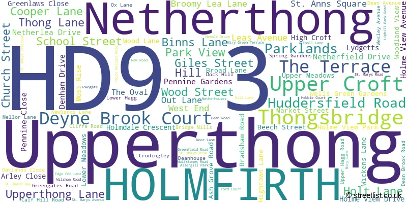
The largest settlement in the HD9 3 postal code is HOLMFIRTH followed by Netherthong, and Upperthong.
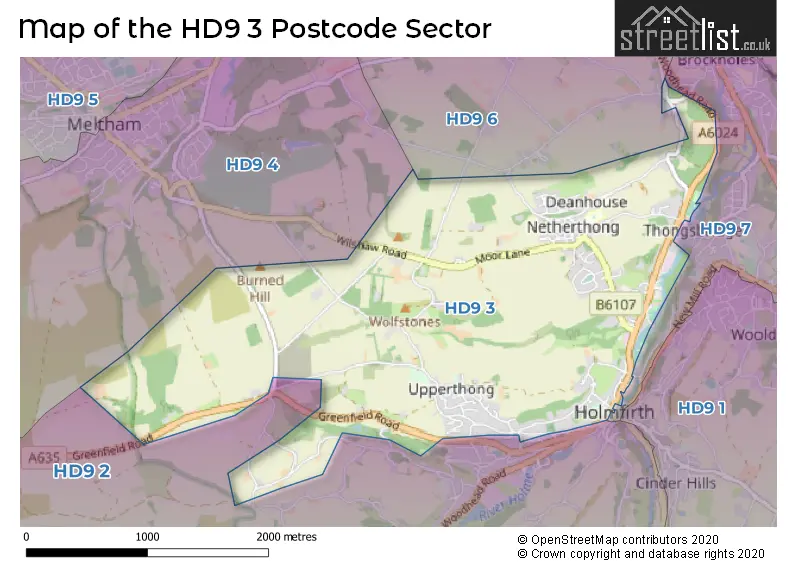
The HD9 3 Postcode shares a border with HD9 6 (Honley), HD9 4 (Meltham), HD9 2 (HOLMFIRTH, Holmbridge, Hade Edge) and HD9 7 (New Mill, Brockholes, Thongsbridge).
The sector is within the post town of HOLMFIRTH.
HD9 3 is a postcode sector within the HD9 postcode district which is within the HD Huddersfield postcode area.
The Royal Mail delivery office for the HD9 3 postal sector is the Holmfirth Delivery Office.
The area of the HD9 3 postcode sector is 3.14 square miles which is 8.14 square kilometres or 2,011.40 square acres.
Waterways within the HD9 3 postcode sector include the River Holme.

Map of the HD9 3 Postcode Sector
Explore the HD9 3 postcode sector by using our free interactive map.
| H | D | 9 | - | 3 | X | X |
| H | D | 9 | Space | 3 | Letter | Letter |
Official List of Streets
Upperthong (20 Streets)
Netherthong (27 Streets)
HOLMFIRTH (39 Streets)
Unofficial Streets or Alternative Spellings
HOLMFIRTH
BERRY BANK LANE BRIDGE LANE NORRIDGE BOTTOM SCHOOL STREET VICTORIA STREET ACRES LANE BACK LANE BANKS ROAD BROAD LANE FARM CARR HOUSE ROAD CRODINGLEY FARM COURT CROWN LANE DEANHOUSE LANE FIVE LANE ENDS HAGG WOOD ROAD HAIGH LANE HARDEN HILL ROAD HARDEN MOSS ROAD HOLME VALLEY COURT LANCASTER LANE LYDGETT FARM COURT PARK HEAD LANE STABLE COURT TOWN HALL STREET WHITE WALLS LANEThongsbridge
MIRY LANEMeltham
WILSHAW MILL ROAD WILSHAW ROADHonley
OLDFIELD ROAD WOODHEAD ROADWeather Forecast for HD9 3
Press Button to Show Forecast for Holmfirth
| Time Period | Icon | Description | Temperature | Rain Probability | Wind |
|---|---|---|---|---|---|
| 15:00 to 18:00 | Overcast | 8.0°C (feels like 5.0°C) | 11.00% | E 7 mph | |
| 18:00 to 21:00 | Cloudy | 6.0°C (feels like 4.0°C) | 26.00% | E 9 mph | |
| 21:00 to 00:00 | Cloudy | 5.0°C (feels like 4.0°C) | 7.00% | ENE 4 mph |
Press Button to Show Forecast for Holmfirth
| Time Period | Icon | Description | Temperature | Rain Probability | Wind |
|---|---|---|---|---|---|
| 00:00 to 03:00 | Partly cloudy (night) | 3.0°C (feels like 2.0°C) | 1.00% | E 4 mph | |
| 03:00 to 06:00 | Partly cloudy (night) | 2.0°C (feels like 0.0°C) | 1.00% | ENE 2 mph | |
| 06:00 to 09:00 | Cloudy | 3.0°C (feels like 1.0°C) | 6.00% | ENE 2 mph | |
| 09:00 to 12:00 | Overcast | 6.0°C (feels like 4.0°C) | 19.00% | ENE 9 mph | |
| 12:00 to 15:00 | Overcast | 8.0°C (feels like 6.0°C) | 14.00% | ENE 9 mph | |
| 15:00 to 18:00 | Light rain | 8.0°C (feels like 5.0°C) | 54.00% | ENE 9 mph | |
| 18:00 to 21:00 | Overcast | 7.0°C (feels like 5.0°C) | 12.00% | ENE 9 mph | |
| 21:00 to 00:00 | Cloudy | 6.0°C (feels like 3.0°C) | 8.00% | NE 7 mph |
Press Button to Show Forecast for Holmfirth
| Time Period | Icon | Description | Temperature | Rain Probability | Wind |
|---|---|---|---|---|---|
| 00:00 to 03:00 | Overcast | 5.0°C (feels like 2.0°C) | 8.00% | NNE 7 mph | |
| 03:00 to 06:00 | Overcast | 5.0°C (feels like 2.0°C) | 12.00% | N 9 mph | |
| 06:00 to 09:00 | Light rain | 5.0°C (feels like 2.0°C) | 50.00% | N 11 mph | |
| 09:00 to 12:00 | Light rain | 6.0°C (feels like 3.0°C) | 52.00% | NNW 11 mph | |
| 12:00 to 15:00 | Light rain | 8.0°C (feels like 5.0°C) | 50.00% | NW 11 mph | |
| 15:00 to 18:00 | Light rain | 9.0°C (feels like 7.0°C) | 46.00% | WNW 11 mph | |
| 18:00 to 21:00 | Cloudy | 9.0°C (feels like 7.0°C) | 9.00% | W 9 mph | |
| 21:00 to 00:00 | Clear night | 7.0°C (feels like 4.0°C) | 2.00% | WSW 9 mph |
Press Button to Show Forecast for Holmfirth
| Time Period | Icon | Description | Temperature | Rain Probability | Wind |
|---|---|---|---|---|---|
| 00:00 to 03:00 | Clear night | 6.0°C (feels like 3.0°C) | 1.00% | SW 7 mph | |
| 03:00 to 06:00 | Clear night | 5.0°C (feels like 2.0°C) | 1.00% | SSW 7 mph | |
| 06:00 to 09:00 | Sunny day | 6.0°C (feels like 3.0°C) | 1.00% | SSW 7 mph | |
| 09:00 to 12:00 | Partly cloudy (day) | 10.0°C (feels like 8.0°C) | 2.00% | S 11 mph | |
| 12:00 to 15:00 | Cloudy | 13.0°C (feels like 10.0°C) | 6.00% | S 13 mph | |
| 15:00 to 18:00 | Cloudy | 13.0°C (feels like 10.0°C) | 7.00% | S 13 mph | |
| 18:00 to 21:00 | Partly cloudy (day) | 13.0°C (feels like 10.0°C) | 4.00% | S 11 mph | |
| 21:00 to 00:00 | Clear night | 10.0°C (feels like 8.0°C) | 2.00% | SSE 9 mph |
Press Button to Show Forecast for Holmfirth
| Time Period | Icon | Description | Temperature | Rain Probability | Wind |
|---|---|---|---|---|---|
| 00:00 to 03:00 | Clear night | 8.0°C (feels like 6.0°C) | 2.00% | SSE 9 mph | |
| 03:00 to 06:00 | Clear night | 6.0°C (feels like 4.0°C) | 1.00% | SE 7 mph | |
| 06:00 to 09:00 | Sunny day | 7.0°C (feels like 5.0°C) | 3.00% | SE 7 mph | |
| 09:00 to 12:00 | Cloudy | 10.0°C (feels like 8.0°C) | 8.00% | ESE 9 mph | |
| 12:00 to 15:00 | Partly cloudy (day) | 14.0°C (feels like 12.0°C) | 5.00% | ESE 11 mph | |
| 15:00 to 18:00 | Partly cloudy (day) | 15.0°C (feels like 13.0°C) | 9.00% | ESE 11 mph | |
| 18:00 to 21:00 | Partly cloudy (day) | 14.0°C (feels like 12.0°C) | 7.00% | ESE 9 mph | |
| 21:00 to 00:00 | Cloudy | 11.0°C (feels like 10.0°C) | 8.00% | E 7 mph |
Schools and Places of Education Within the HD9 3 Postcode Sector
Netherthong Primary School
Community school
School Street, Holmfirth, West Yorkshire, HD9 3EB
Head: Miss R Kelly
Ofsted Rating: Good
Inspection: 2023-11-29 (149 days ago)
Website: Visit Netherthong Primary School Website
Phone: 01484681950
Number of Pupils: 220
House Prices in the HD9 3 Postcode Sector
| Type of Property | 2018 Average | 2018 Sales | 2017 Average | 2017 Sales | 2016 Average | 2016 Sales | 2015 Average | 2015 Sales |
|---|---|---|---|---|---|---|---|---|
| Detached | £450,161 | 42 | £402,850 | 27 | £413,024 | 21 | £337,711 | 26 |
| Semi-Detached | £214,719 | 16 | £221,800 | 15 | £151,611 | 9 | £190,181 | 8 |
| Terraced | £185,210 | 29 | £168,188 | 24 | £157,338 | 20 | £172,400 | 25 |
| Flats | £139,917 | 6 | £141,969 | 8 | £118,643 | 7 | £171,500 | 6 |
Important Postcodes HD9 3 in the Postcode Sector
HD9 3AS is the postcode for Civic Hall, Huddersfield Road
HD9 3EB is the postcode for Netherthong Cp School, School Street, and Netherthong Cp School, School Street, Netherthong
HD9 3JH is the postcode for Holmfirth Library, 47 Huddersfield Road
HD9 3JL is the postcode for DANCE STUDIO, GYM AND CHANGING ROOMS, Holmfirth Swimming Pool, Huddersfield Road, and West Yorkshire Police, Huddersfield Road
HD9 3TQ is the postcode for Oaklands Health Centre, 161 Huddersfield Road
HD9 3TR is the postcode for Elmwood Health Centre, Huddersfield Road
HD9 3TS is the postcode for Holme Valley Memorial Hospital, Huddersfield Road
| The HD9 3 Sector is within these Local Authorities |
|
|---|---|
| The HD9 3 Sector is within these Counties |
|
| The HD9 3 Sector is within these Water Company Areas |
|