The HD9 7 postcode sector stands on the South Yorkshire and West Yorkshire border.
Did you know? According to the 2021 Census, the HD9 7 postcode sector is home to a bustling 5,133 residents!
Given that each sector allows for 400 unique postcode combinations. Letters C, I, K, M, O and V are not allowed in the last two letters of a postcode. With 183 postcodes already in use, this leaves 217 units available.
The largest settlement in the HD9 7 postal code is New Mill followed by Brockholes, and Thongsbridge.
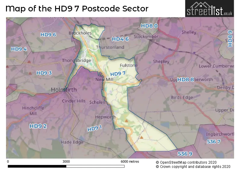
The HD9 7 Postcode shares a border with S36 4 (Crow Edge, Stocksbridge, Dunford Bridge), S36 9 (Thurlstone, Millhouse Green, Penistone), HD4 6 (HUDDERSFIELD, Thurstonland, Newsome), HD8 8 (Denby Dale, Shepley, Shelley), HD9 1 (HOLMFIRTH, Scholes, New Mill), HD9 3 (HOLMFIRTH, Netherthong, Upperthong), HD9 6 (Honley) and HD9 2 (HOLMFIRTH, Holmbridge, Hade Edge).
The sector is within the post town of HOLMFIRTH.
HD9 7 is a postcode sector within the HD9 postcode district which is within the HD Huddersfield postcode area.
The Royal Mail delivery office for the HD9 7 postal sector is the Holmfirth Delivery Office.
The area of the HD9 7 postcode sector is 4.33 square miles which is 11.20 square kilometres or 2,768.47 square acres.
Waterways within the HD9 7 postcode sector include the River Holme.

Map of the HD9 7 Postcode Sector
Explore the HD9 7 postcode sector by using our free interactive map.
| H | D | 9 | - | 7 | X | X |
| H | D | 9 | Space | 7 | Letter | Letter |
Official List of Streets
Thongsbridge (22 Streets)
Brockholes (23 Streets)
New Mill (39 Streets)
HOLMFIRTH (24 Streets)
Hepworth (4 Streets)
Jackson Bridge (3 Streets)
Unofficial Streets or Alternative Spellings
Shepley
GATE FOOT LANEStocksmoor
FULSTONE ROADNew Mill
DALESIDE AVENUE GREENHILL BANK ROAD LYDGATE CLOSE LYDGATE DRIVE MOORCROFT PARK DRIVE WILDSPUR GROVE WILDSPUR MILLS ACRE LANE BARRACLOUGH ROW BIRDSNEST LANE BROWNS EDGE ROAD CALF HEY LANE CHEESE GATE NAB SIDE COAL PIT GATE CROWN LANE DICK EDGE LANE FAR WELL LANE FULSTONE HALL ROAD HAGG WOOD ROAD HALL ING ROAD HEY SLACK LANE HEY SLACK WELL HOLLIN HOUSE LANE LANCASTER LANE LOWER MAYTHORNE LANE MEAL HILL LANE MILL SHAW LANE MOORCROFT DRIVE MYTHOLM BRIDGE OCCUPATION LANE OLD BAR LANE POTTERS GATE RAY GATE RIGHTOX ROAD ROCK COTTAGES ROCK TERRACE ROCKMILL ROAD SCALEY GATE SCALY GATE SCAR END LANE SCAR HOLE LANE SINKING WOOD (NEW MILL ROAD) SLACK TOP LANE SMITHY PLACE LANE STALEY ROYD LANE TENTER HILL THONGS BRIDGE TOWN GATE UPPER MAYTHORNE LANE UPPER SUDE HILL ROAD VICTORIA YARD WHAMS ROAD WHITE LEY BANK WOODPIT LANEHepworth
BARNSIDE LANE BEDDING EDGE ROAD SNUG LANEHOLMFIRTH
BACK LANE BANK LANE BILL LANE ROBERT LANE ROSEGARTH AVENUE STATION ROAD VICTORIA SQUAREThongsbridge
HUDDERSFIELD ROADHade Edge
DUNFORD ROADJackson Bridge
CHAPEL BANKThurstonland
TOP OF THE BANKMillhouse Green
WHITLEY ROADHonley
WOODHEAD ROADWeather Forecast for HD9 7
Press Button to Show Forecast for Holmfirth
| Time Period | Icon | Description | Temperature | Rain Probability | Wind |
|---|---|---|---|---|---|
| 12:00 to 15:00 | Cloudy | 7.0°C (feels like 4.0°C) | 10.00% | E 7 mph | |
| 15:00 to 18:00 | Overcast | 8.0°C (feels like 5.0°C) | 11.00% | E 7 mph | |
| 18:00 to 21:00 | Cloudy | 6.0°C (feels like 4.0°C) | 26.00% | E 9 mph | |
| 21:00 to 00:00 | Cloudy | 5.0°C (feels like 4.0°C) | 7.00% | ENE 4 mph |
Press Button to Show Forecast for Holmfirth
| Time Period | Icon | Description | Temperature | Rain Probability | Wind |
|---|---|---|---|---|---|
| 00:00 to 03:00 | Partly cloudy (night) | 3.0°C (feels like 2.0°C) | 1.00% | E 4 mph | |
| 03:00 to 06:00 | Partly cloudy (night) | 2.0°C (feels like 0.0°C) | 1.00% | ENE 2 mph | |
| 06:00 to 09:00 | Cloudy | 3.0°C (feels like 1.0°C) | 6.00% | ENE 2 mph | |
| 09:00 to 12:00 | Overcast | 6.0°C (feels like 4.0°C) | 19.00% | ENE 9 mph | |
| 12:00 to 15:00 | Overcast | 8.0°C (feels like 6.0°C) | 14.00% | ENE 9 mph | |
| 15:00 to 18:00 | Light rain | 8.0°C (feels like 5.0°C) | 54.00% | ENE 9 mph | |
| 18:00 to 21:00 | Overcast | 7.0°C (feels like 5.0°C) | 12.00% | ENE 9 mph | |
| 21:00 to 00:00 | Cloudy | 6.0°C (feels like 3.0°C) | 8.00% | NE 7 mph |
Press Button to Show Forecast for Holmfirth
| Time Period | Icon | Description | Temperature | Rain Probability | Wind |
|---|---|---|---|---|---|
| 00:00 to 03:00 | Overcast | 5.0°C (feels like 2.0°C) | 8.00% | NNE 7 mph | |
| 03:00 to 06:00 | Overcast | 5.0°C (feels like 2.0°C) | 12.00% | N 9 mph | |
| 06:00 to 09:00 | Light rain | 5.0°C (feels like 2.0°C) | 50.00% | N 11 mph | |
| 09:00 to 12:00 | Light rain | 6.0°C (feels like 3.0°C) | 52.00% | NNW 11 mph | |
| 12:00 to 15:00 | Light rain | 8.0°C (feels like 5.0°C) | 50.00% | NW 11 mph | |
| 15:00 to 18:00 | Light rain | 9.0°C (feels like 7.0°C) | 46.00% | WNW 11 mph | |
| 18:00 to 21:00 | Cloudy | 9.0°C (feels like 7.0°C) | 9.00% | W 9 mph | |
| 21:00 to 00:00 | Clear night | 7.0°C (feels like 4.0°C) | 2.00% | WSW 9 mph |
Press Button to Show Forecast for Holmfirth
| Time Period | Icon | Description | Temperature | Rain Probability | Wind |
|---|---|---|---|---|---|
| 00:00 to 03:00 | Clear night | 6.0°C (feels like 3.0°C) | 1.00% | SW 7 mph | |
| 03:00 to 06:00 | Clear night | 5.0°C (feels like 2.0°C) | 1.00% | SSW 7 mph | |
| 06:00 to 09:00 | Sunny day | 6.0°C (feels like 3.0°C) | 1.00% | SSW 7 mph | |
| 09:00 to 12:00 | Partly cloudy (day) | 10.0°C (feels like 8.0°C) | 2.00% | S 11 mph | |
| 12:00 to 15:00 | Cloudy | 13.0°C (feels like 10.0°C) | 6.00% | S 13 mph | |
| 15:00 to 18:00 | Cloudy | 13.0°C (feels like 10.0°C) | 7.00% | S 13 mph | |
| 18:00 to 21:00 | Partly cloudy (day) | 13.0°C (feels like 10.0°C) | 4.00% | S 11 mph | |
| 21:00 to 00:00 | Clear night | 10.0°C (feels like 8.0°C) | 2.00% | SSE 9 mph |
Press Button to Show Forecast for Holmfirth
| Time Period | Icon | Description | Temperature | Rain Probability | Wind |
|---|---|---|---|---|---|
| 00:00 to 03:00 | Clear night | 8.0°C (feels like 6.0°C) | 2.00% | SSE 9 mph | |
| 03:00 to 06:00 | Clear night | 6.0°C (feels like 4.0°C) | 1.00% | SE 7 mph | |
| 06:00 to 09:00 | Sunny day | 7.0°C (feels like 5.0°C) | 3.00% | SE 7 mph | |
| 09:00 to 12:00 | Cloudy | 10.0°C (feels like 8.0°C) | 8.00% | ESE 9 mph | |
| 12:00 to 15:00 | Partly cloudy (day) | 14.0°C (feels like 12.0°C) | 5.00% | ESE 11 mph | |
| 15:00 to 18:00 | Partly cloudy (day) | 15.0°C (feels like 13.0°C) | 9.00% | ESE 11 mph | |
| 18:00 to 21:00 | Partly cloudy (day) | 14.0°C (feels like 12.0°C) | 7.00% | ESE 9 mph | |
| 21:00 to 00:00 | Cloudy | 11.0°C (feels like 10.0°C) | 8.00% | E 7 mph |
Schools and Places of Education Within the HD9 7 Postcode Sector
Brockholes Church of England Voluntary Controlled Junior and Infant School
Voluntary controlled school
Brockholes Lane, Holmfirth, West Yorkshire, HD9 7EB
Head: Miss Clare Thomas
Ofsted Rating: Outstanding
Inspection: 2023-12-14 (134 days ago)
Website: Visit Brockholes Church of England Voluntary Controlled Junior and Infant School Website
Phone: 01484666601
Number of Pupils: 210
Holmfirth High School
Community school
Heys Road, Holmfirth, West Yorkshire, HD9 7SE
Head: Mr Ben Stitchman
Ofsted Rating: Outstanding
Inspection: 2023-06-21 (310 days ago)
Website: Visit Holmfirth High School Website
Phone: 01484691460
Number of Pupils: 1314
House Prices in the HD9 7 Postcode Sector
| Type of Property | 2018 Average | 2018 Sales | 2017 Average | 2017 Sales | 2016 Average | 2016 Sales | 2015 Average | 2015 Sales |
|---|---|---|---|---|---|---|---|---|
| Detached | £346,545 | 33 | £372,200 | 45 | £335,078 | 43 | £324,110 | 19 |
| Semi-Detached | £180,132 | 19 | £202,194 | 20 | £209,498 | 24 | £206,944 | 35 |
| Terraced | £167,535 | 22 | £164,601 | 34 | £165,775 | 50 | £145,795 | 42 |
| Flats | £133,750 | 4 | £168,167 | 3 | £156,964 | 7 | £85,000 | 1 |
Important Postcodes HD9 7 in the Postcode Sector
HD9 7EB is the postcode for Brockholes C of E School, Brockholes Lane, Brockholes, and Brockholes C of E School, Brockholes Lane
HD9 7SE is the postcode for Holmfirth High School, Heys Road, Thongsbridge, MATHS BLOCK, Holmfirth High School, Heys Road, and Holmfirth High School, Heys Road
| The HD9 7 Sector is within these Local Authorities |
|
|---|---|
| The HD9 7 Sector is within these Counties |
|
| The HD9 7 Sector is within these Water Company Areas |
|