The HD9 1 postcode sector stands on the South Yorkshire and West Yorkshire border.
Did you know? According to the 2021 Census, the HD9 1 postcode sector is home to a bustling 6,626 residents!
Given that each sector allows for 400 unique postcode combinations. Letters C, I, K, M, O and V are not allowed in the last two letters of a postcode. With 197 postcodes already in use, this leaves 203 units available.
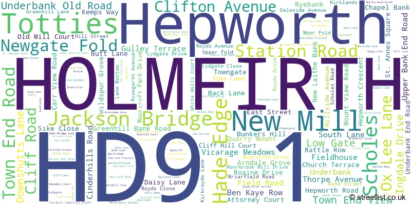
The largest settlement in the HD9 1 postal code is HOLMFIRTH followed by Scholes, and New Mill.
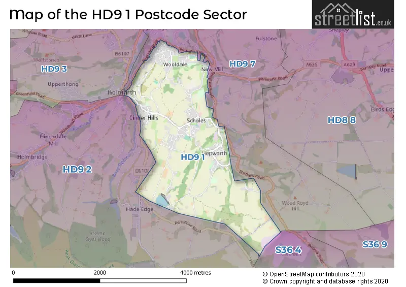
The HD9 1 Postcode shares a border with S36 4 (Crow Edge, Stocksbridge, Dunford Bridge), HD9 2 (HOLMFIRTH, Holmbridge, Hade Edge) and HD9 7 (New Mill, Brockholes, Thongsbridge).
The sector is within the post town of HOLMFIRTH.
HD9 1 is a postcode sector within the HD9 postcode district which is within the HD Huddersfield postcode area.
The Royal Mail delivery office for the HD9 1 postal sector is the Holmfirth Delivery Office.
The area of the HD9 1 postcode sector is 3.15 square miles which is 8.15 square kilometres or 2,013.03 square acres.

Map of the HD9 1 Postcode Sector
Explore the HD9 1 postcode sector by using our free interactive map.
| H | D | 9 | - | 1 | X | X |
| H | D | 9 | Space | 1 | Letter | Letter |
Official List of Streets
Scholes (34 Streets)
HOLMFIRTH (65 Streets)
Jackson Bridge (7 Streets)
Hepworth (20 Streets)
New Mill (16 Streets)
Unofficial Streets or Alternative Spellings
Hepworth
FOSTER PLACE LANE SHEFFIELD ROAD BOSHAM MEWS BOWHSAW MEWS CLIFFE STREET COWCLIFF HILL ROAD CROSS GATE ROAD DYSON LANE FAR FIELD AVENUE FAR FIELD DRIVE GATE HEAD LANE LITTLE CAKE LONGLEY EDGE LANE LONGLEY EDGE ROAD MOORBROW NEW GATE NEW LAITHE LANE OAK SCAR LANE OX LEE LANE PELL COURT PIGGINGER LANE RYECROFT LANE RYEFIELD SLACK LANE SQUARE FIELD STAKE LANE BANK STRINES MOOR ROAD SWEEP LANE TOTTIES LANE UPPER HOUSE ROAD WELL LANE WEST END AVENUE WEST FIELD LANE WOOLDALE CLIFF ROADNew Mill
HOLME LANE HOLMFIRTH ROAD NEW MILL ROADHOLMFIRTH
BRAMBLE BANK VICTORIA SQUAREThongsbridge
HEYS ROAD SPRINGWOOD ROADHade Edge
DUNFORD ROAD PENISTONE ROADWeather Forecast for HD9 1
Press Button to Show Forecast for Holmfirth
| Time Period | Icon | Description | Temperature | Rain Probability | Wind |
|---|---|---|---|---|---|
| 21:00 to 00:00 | Cloudy | 16.0°C (feels like 16.0°C) | 44.00% | SE 4 mph |
Press Button to Show Forecast for Holmfirth
| Time Period | Icon | Description | Temperature | Rain Probability | Wind |
|---|---|---|---|---|---|
| 00:00 to 03:00 | Clear night | 14.0°C (feels like 14.0°C) | 6.00% | E 4 mph | |
| 03:00 to 06:00 | Mist | 12.0°C (feels like 12.0°C) | 18.00% | WSW 2 mph | |
| 06:00 to 09:00 | Mist | 13.0°C (feels like 13.0°C) | 18.00% | ESE 2 mph | |
| 09:00 to 12:00 | Cloudy | 17.0°C (feels like 16.0°C) | 4.00% | SSE 9 mph | |
| 12:00 to 15:00 | Partly cloudy (day) | 19.0°C (feels like 17.0°C) | 1.00% | SSE 11 mph | |
| 15:00 to 18:00 | Cloudy | 20.0°C (feels like 17.0°C) | 5.00% | SSE 13 mph | |
| 18:00 to 21:00 | Cloudy | 19.0°C (feels like 17.0°C) | 5.00% | SSE 11 mph | |
| 21:00 to 00:00 | Cloudy | 15.0°C (feels like 14.0°C) | 7.00% | SSE 9 mph |
Press Button to Show Forecast for Holmfirth
| Time Period | Icon | Description | Temperature | Rain Probability | Wind |
|---|---|---|---|---|---|
| 00:00 to 03:00 | Cloudy | 14.0°C (feels like 13.0°C) | 9.00% | SE 7 mph | |
| 03:00 to 06:00 | Cloudy | 13.0°C (feels like 12.0°C) | 18.00% | ESE 9 mph | |
| 06:00 to 09:00 | Light rain | 13.0°C (feels like 12.0°C) | 46.00% | ESE 9 mph | |
| 09:00 to 12:00 | Heavy rain | 14.0°C (feels like 13.0°C) | 79.00% | ESE 9 mph | |
| 12:00 to 15:00 | Heavy rain | 16.0°C (feels like 14.0°C) | 80.00% | ESE 11 mph | |
| 15:00 to 18:00 | Light rain | 16.0°C (feels like 15.0°C) | 56.00% | SE 11 mph | |
| 18:00 to 21:00 | Light rain | 15.0°C (feels like 14.0°C) | 55.00% | SE 9 mph | |
| 21:00 to 00:00 | Cloudy | 14.0°C (feels like 13.0°C) | 20.00% | SE 7 mph |
Press Button to Show Forecast for Holmfirth
| Time Period | Icon | Description | Temperature | Rain Probability | Wind |
|---|---|---|---|---|---|
| 00:00 to 03:00 | Cloudy | 12.0°C (feels like 11.0°C) | 10.00% | SE 7 mph | |
| 03:00 to 06:00 | Cloudy | 11.0°C (feels like 10.0°C) | 5.00% | SE 4 mph | |
| 06:00 to 09:00 | Overcast | 12.0°C (feels like 11.0°C) | 9.00% | ESE 4 mph | |
| 09:00 to 12:00 | Cloudy | 14.0°C (feels like 13.0°C) | 8.00% | ESE 7 mph | |
| 12:00 to 15:00 | Light rain shower (day) | 17.0°C (feels like 15.0°C) | 31.00% | ESE 9 mph | |
| 15:00 to 18:00 | Light rain shower (day) | 17.0°C (feels like 16.0°C) | 39.00% | ESE 9 mph | |
| 18:00 to 21:00 | Light rain shower (day) | 16.0°C (feels like 15.0°C) | 33.00% | ESE 7 mph | |
| 21:00 to 00:00 | Clear night | 14.0°C (feels like 13.0°C) | 5.00% | ESE 4 mph |
Press Button to Show Forecast for Holmfirth
| Time Period | Icon | Description | Temperature | Rain Probability | Wind |
|---|---|---|---|---|---|
| 00:00 to 03:00 | Clear night | 12.0°C (feels like 12.0°C) | 2.00% | SE 2 mph | |
| 03:00 to 06:00 | Mist | 11.0°C (feels like 11.0°C) | 14.00% | WSW 2 mph | |
| 06:00 to 09:00 | Fog | 12.0°C (feels like 11.0°C) | 15.00% | W 2 mph | |
| 09:00 to 12:00 | Cloudy | 15.0°C (feels like 15.0°C) | 6.00% | WNW 4 mph | |
| 12:00 to 15:00 | Cloudy | 17.0°C (feels like 17.0°C) | 9.00% | ESE 4 mph | |
| 15:00 to 18:00 | Cloudy | 18.0°C (feels like 17.0°C) | 13.00% | NW 7 mph | |
| 18:00 to 21:00 | Light rain shower (day) | 16.0°C (feels like 16.0°C) | 33.00% | WNW 7 mph | |
| 21:00 to 00:00 | Light rain shower (night) | 14.0°C (feels like 13.0°C) | 32.00% | WNW 7 mph |
Schools and Places of Education Within the HD9 1 Postcode Sector
Hepworth Junior and Infant School
Community school
Maingate, Holmfirth, West Yorkshire, HD9 1TJ
Head: Mr Mark Crouch
Ofsted Rating: Good
Inspection: 2023-01-11 (487 days ago)
Website: Visit Hepworth Junior and Infant School Website
Phone: 01484685450
Number of Pupils: 117
House Prices in the HD9 1 Postcode Sector
| Type of Property | 2018 Average | 2018 Sales | 2017 Average | 2017 Sales | 2016 Average | 2016 Sales | 2015 Average | 2015 Sales |
|---|---|---|---|---|---|---|---|---|
| Detached | £318,779 | 33 | £349,828 | 34 | £317,431 | 36 | £314,548 | 41 |
| Semi-Detached | £219,885 | 23 | £221,052 | 24 | £191,125 | 28 | £185,253 | 34 |
| Terraced | £163,244 | 41 | £151,059 | 45 | £154,351 | 55 | £151,889 | 50 |
| Flats | £123,429 | 7 | £139,933 | 9 | £157,786 | 7 | £120,125 | 8 |
Important Postcodes HD9 1 in the Postcode Sector
HD9 1LJ is the postcode for Wooldale Junior School, Royds Avenue, and New Mill Junior School, Royds Avenue, New Mill
HD9 1LS is the postcode for New Mill Infant School, Kirkroyds Lane, Lydgate School, Kirkroyds Lane, and New Mill Infant School, Kirkroyds Lane, New Mill
HD9 1SZ is the postcode for Scholes Junior & Infant School, Wadman Road, and Scholes Junior & Infant School, Wadman Road, Scholes
HD9 1TJ is the postcode for Hepworth Junior & Infant School, Maingate
| The HD9 1 Sector is within these Local Authorities |
|
|---|---|
| The HD9 1 Sector is within these Counties |
|
| The HD9 1 Sector is within these Water Company Areas |
|