The HD4 postcode district is a postal district located in the HD Huddersfield postcode area with a population of 30,027 residents according to the 2021 England and Wales Census.
The area of the HD4 postcode district is 10.36 square miles which is 26.84 square kilometres or 6,631.43 acres.
Currently, the HD4 district has about 728 postcode units spread across 3 geographic postcode sectors.
Given that each sector allows for 400 unique postcode combinations, the district has a capacity of 1,200 postcodes. With 728 postcodes already in use, this leaves 472 units available.
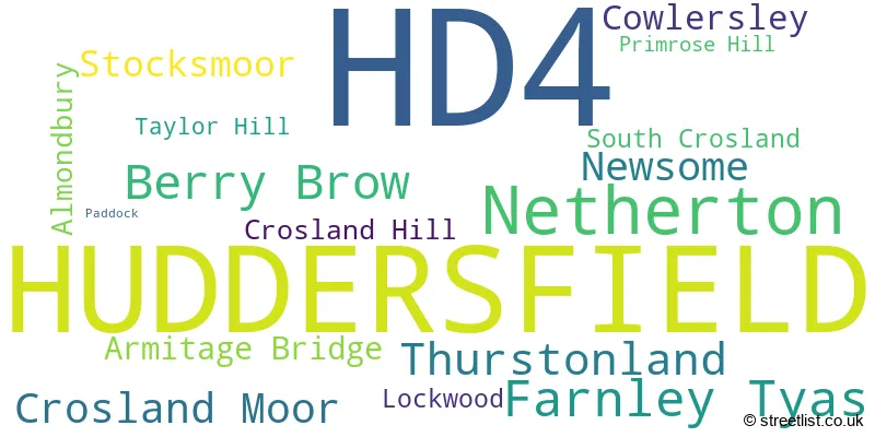
The largest settlement in the HD4 postal code is HUDDERSFIELD followed by Netherton, and Newsome.
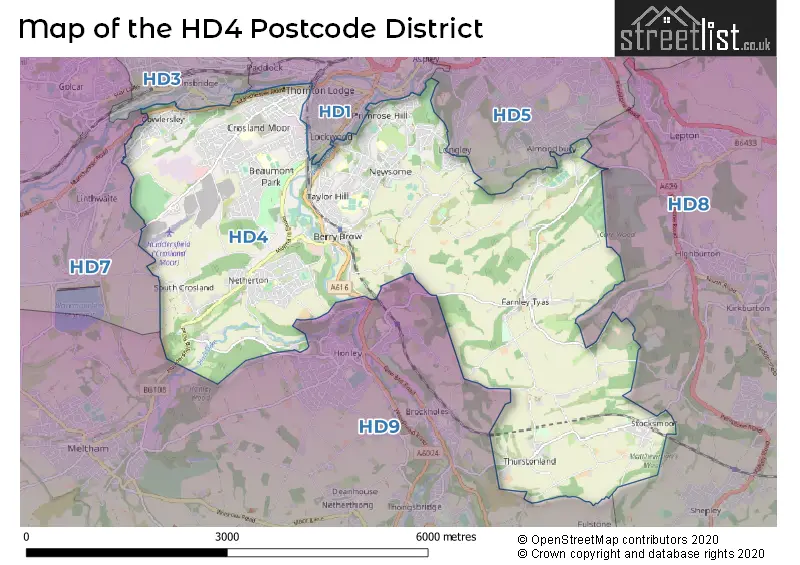
The HD4 Postcode shares a border with HD8 (Kirkburton, Skelmanthorpe, Lepton), HD1 (HUDDERSFIELD, Paddock, Lockwood), HD3 (HUDDERSFIELD, Longwood, Lindley), HD5 (HUDDERSFIELD, Almondbury, Moldgreen), HD7 (Golcar, Slaithwaite, Marsden) and HD9 (HOLMFIRTH, Meltham, Honley).
In the HD4 postcode district, Huddersfield is the primary settlement, located in the county of West Yorkshire, England. Other significant settlements within this district include Cowlersley, Crosland Moor, Lockwood, Paddock, Almondbury, Berry Brow, Farnley Tyas, Newsome, Primrose Hill, Stocksmoor, Taylor Hill, Thurstonland, Armitage Bridge, Crosland Hill, Netherton, and South Crosland. The most significant post town in this district is Huddersfield.
For the district HD4, we have data on 3 postcode sectors. Here's a breakdown: The sector HD4 5, covers Huddersfield in West Yorkshire. The sector HD4 6, covers Huddersfield and Thurstonland and Farnley Tyas in West Yorkshire. The sector HD4 7, covers Huddersfield and Netherton in West Yorkshire.

Map of the HD4 Postcode District
Explore the HD4 postcode district by using our free interactive map.
When it comes to local government, postal geography often disregards political borders. However, for a breakdown in the HD4 District: the district mostly encompasses the Kirklees District (B) area with a total of 724 postcodes.
Recent House Sales in HD4
| Date | Price | Address |
|---|---|---|
| 18/10/2023 | £210,000 | Dryclough Avenue, Huddersfield, HD4 5JU |
| 10/10/2023 | £307,000 | Mason Court, Huddersfield, HD4 5NE |
| 09/10/2023 | £210,000 | Sharp Lane, Almondbury, Huddersfield, HD4 6TH |
| 06/10/2023 | £195,000 | Stile Common Road, Huddersfield, HD4 6DD |
| 22/09/2023 | £75,000 | Woodhead Road, Lockwood, Huddersfield, HD4 6EP |
| 15/09/2023 | £56,278 | Sandene Avenue, Huddersfield, HD4 5LY |
| 15/09/2023 | £109,000 | Bowling Street, Cowlersley, Huddersfield, HD4 5TF |
| 15/09/2023 | £65,000 | Woodhead Road, Huddersfield, HD4 6ET |
| 04/09/2023 | £139,000 | Avison Road, Huddersfield, HD4 5TL |
| 01/09/2023 | £92,500 | Netherton Fold, Huddersfield, HD4 7HB |
Where is the HD4 Postcode District?
The postcode district for HD4 is located in Huddersfield. It is a district town in the vicinity of several nearby towns. To the South, there is Holmfirth, which is approximately 3.89 miles away. To the North East, there is Mirfield, situated approximately 4.06 miles away. Further North West, there is Elland, which is approximately 5.39 miles away. Additionally, to the North, there is Brighouse, located approximately 5.96 miles away. It is important to note that Huddersfield is quite far from the centre of London, with a distance of 161.52 miles.
The district is within the post town of HUDDERSFIELD.
The sector has postcodes within the nation of England.
The HD4 Postcode District is in the Calderdale and Kirklees region of West Yorkshire within the Yorkshire and The Humber.
Weather Forecast for HD4
Press Button to Show Forecast for Almondbury
| Time Period | Icon | Description | Temperature | Rain Probability | Wind |
|---|---|---|---|---|---|
| 12:00 to 15:00 | Cloudy | 20.0°C (feels like 20.0°C) | 5.00% | SE 4 mph | |
| 15:00 to 18:00 | Cloudy | 21.0°C (feels like 21.0°C) | 5.00% | SSE 2 mph | |
| 18:00 to 21:00 | Cloudy | 21.0°C (feels like 21.0°C) | 3.00% | SE 4 mph | |
| 21:00 to 00:00 | Partly cloudy (night) | 17.0°C (feels like 17.0°C) | 0.00% | SSE 7 mph |
Press Button to Show Forecast for Almondbury
| Time Period | Icon | Description | Temperature | Rain Probability | Wind |
|---|---|---|---|---|---|
| 00:00 to 03:00 | Clear night | 15.0°C (feels like 14.0°C) | 0.00% | ESE 4 mph | |
| 03:00 to 06:00 | Cloudy | 13.0°C (feels like 13.0°C) | 3.00% | ESE 2 mph | |
| 06:00 to 09:00 | Cloudy | 13.0°C (feels like 13.0°C) | 3.00% | ESE 2 mph | |
| 09:00 to 12:00 | Cloudy | 17.0°C (feels like 16.0°C) | 3.00% | ESE 7 mph | |
| 12:00 to 15:00 | Cloudy | 20.0°C (feels like 18.0°C) | 4.00% | SE 9 mph | |
| 15:00 to 18:00 | Cloudy | 21.0°C (feels like 19.0°C) | 5.00% | SE 9 mph | |
| 18:00 to 21:00 | Cloudy | 20.0°C (feels like 19.0°C) | 4.00% | ESE 9 mph | |
| 21:00 to 00:00 | Cloudy | 16.0°C (feels like 14.0°C) | 3.00% | ESE 9 mph |
Press Button to Show Forecast for Almondbury
| Time Period | Icon | Description | Temperature | Rain Probability | Wind |
|---|---|---|---|---|---|
| 00:00 to 03:00 | Cloudy | 13.0°C (feels like 12.0°C) | 3.00% | E 7 mph | |
| 03:00 to 06:00 | Cloudy | 11.0°C (feels like 10.0°C) | 4.00% | E 4 mph | |
| 06:00 to 09:00 | Cloudy | 11.0°C (feels like 11.0°C) | 4.00% | E 4 mph | |
| 09:00 to 12:00 | Cloudy | 15.0°C (feels like 14.0°C) | 4.00% | ESE 7 mph | |
| 12:00 to 15:00 | Cloudy | 19.0°C (feels like 18.0°C) | 4.00% | ESE 9 mph | |
| 15:00 to 18:00 | Light rain shower (day) | 20.0°C (feels like 18.0°C) | 35.00% | SE 11 mph | |
| 18:00 to 21:00 | Cloudy | 18.0°C (feels like 17.0°C) | 21.00% | SE 9 mph | |
| 21:00 to 00:00 | Light rain | 15.0°C (feels like 15.0°C) | 48.00% | SE 4 mph |
Press Button to Show Forecast for Almondbury
| Time Period | Icon | Description | Temperature | Rain Probability | Wind |
|---|---|---|---|---|---|
| 00:00 to 03:00 | Cloudy | 14.0°C (feels like 14.0°C) | 17.00% | ESE 4 mph | |
| 03:00 to 06:00 | Cloudy | 13.0°C (feels like 13.0°C) | 14.00% | SE 4 mph | |
| 06:00 to 09:00 | Cloudy | 14.0°C (feels like 13.0°C) | 13.00% | SE 4 mph | |
| 09:00 to 12:00 | Cloudy | 16.0°C (feels like 14.0°C) | 13.00% | SSE 9 mph | |
| 12:00 to 15:00 | Light rain shower (day) | 17.0°C (feels like 15.0°C) | 34.00% | SSE 11 mph | |
| 15:00 to 18:00 | Cloudy | 17.0°C (feels like 15.0°C) | 23.00% | SSE 11 mph | |
| 18:00 to 21:00 | Light rain | 16.0°C (feels like 14.0°C) | 55.00% | SSE 11 mph | |
| 21:00 to 00:00 | Light rain | 14.0°C (feels like 13.0°C) | 55.00% | SE 9 mph |
Press Button to Show Forecast for Almondbury
| Time Period | Icon | Description | Temperature | Rain Probability | Wind |
|---|---|---|---|---|---|
| 00:00 to 03:00 | Cloudy | 13.0°C (feels like 11.0°C) | 20.00% | SE 9 mph | |
| 03:00 to 06:00 | Light rain | 12.0°C (feels like 11.0°C) | 46.00% | SE 7 mph | |
| 06:00 to 09:00 | Light rain | 12.0°C (feels like 11.0°C) | 46.00% | SE 9 mph | |
| 09:00 to 12:00 | Light rain shower (day) | 13.0°C (feels like 12.0°C) | 34.00% | SSE 11 mph | |
| 12:00 to 15:00 | Light rain shower (day) | 15.0°C (feels like 13.0°C) | 34.00% | SSE 11 mph | |
| 15:00 to 18:00 | Light rain shower (day) | 16.0°C (feels like 14.0°C) | 36.00% | SSE 11 mph | |
| 18:00 to 21:00 | Light rain shower (day) | 15.0°C (feels like 13.0°C) | 35.00% | SSE 11 mph | |
| 21:00 to 00:00 | Partly cloudy (night) | 12.0°C (feels like 11.0°C) | 10.00% | S 9 mph |
| Postcode Sector | Delivery Office |
|---|---|
| HD4 5 | Huddersfield Delivery Office |
| HD4 6 | Huddersfield Delivery Office |
| HD4 7 | Huddersfield Delivery Office |
| H | D | 4 | - | X | X | X |
| H | D | 4 | Space | Numeric | Letter | Letter |
Tourist Attractions within the HD4 Postcode Area
We found 1 visitor attractions within the HD4 postcode area
| Castle Hill and Victoria Tower |
|---|
| Historic Properties |
| Historic Monument / Archaeological Site |
| View Castle Hill and Victoria Tower on Google Maps |
Current Monthly Rental Prices
| # Bedrooms | Min Price | Max Price | Avg Price |
|---|---|---|---|
| £585 | £585 | £585 | |
| 1 | £429 | £575 | £493 |
| 2 | £368 | £1,005 | £721 |
| 3 | £429 | £975 | £697 |
| 4 | £412 | £412 | £412 |
| 5 | £800 | £800 | £800 |
| 6 | £2,470 | £2,470 | £2,470 |
Current House Prices
| # Bedrooms | Min Price | Max Price | Avg Price |
|---|---|---|---|
| £3,000 | £300,000 | £159,600 | |
| 1 | £50,000 | £130,000 | £76,859 |
| 2 | £50,000 | £375,000 | £141,485 |
| 3 | £75,000 | £900,000 | £215,479 |
| 4 | £160,000 | £900,000 | £378,585 |
| 5 | £230,000 | £950,000 | £560,500 |
| 6 | £425,000 | £1,950,000 | £1,187,500 |
| 7 | £839,000 | £1,800,000 | £1,319,500 |
Estate Agents who Operate in the HD4 District
| Logo | Name | Brand Name | Address | Contact Number | Total Properties |
|---|---|---|---|---|---|
 | Huddersfield | William H. Brown | 8 Westgate, Huddersfield, HD1 1NN | 01484 627776 | 29 |
 | Huddersfield | Ryder & Dutton | 2 Acre Street, Lindley, Huddersfield, HD3 3DU | 01484 627355 | 12 |
 | Huddersfield | Reeds Rains | 23 Market Place, Huddersfield, HD1 2AA | 01484 627852 | 9 |
 | Huddersfield | Whitegates | 6 The Cherry Tree Centre Market Street Huddersfield HD1 2ET | 01484 627972 | 9 |
 | Almondbury | Paisley Properties | 75-77 Northgate, Almondbury, Huddersfield, HD5 8RX | 01484 627578 | 8 |
Yearly House Price Averages for the HD4 Postcode District
| Type of Property | 2018 Average | 2018 Sales | 2017 Average | 2017 Sales | 2016 Average | 2016 Sales | 2015 Average | 2015 Sales |
|---|---|---|---|---|---|---|---|---|
| Detached | £283,935 | 88 | £265,717 | 83 | £286,124 | 107 | £256,199 | 83 |
| Semi-Detached | £157,550 | 138 | £148,944 | 140 | £154,566 | 111 | £142,867 | 128 |
| Terraced | £103,339 | 223 | £108,150 | 210 | £105,997 | 214 | £100,739 | 216 |
| Flats | £100,103 | 20 | £110,167 | 15 | £72,104 | 27 | £108,615 | 21 |