The CH60 postcode district is a postal district located in the CH Chester postcode area with a population of 13,052 residents according to the 2021 England and Wales Census.
The area of the CH60 postcode district is 4.20 square miles which is 10.88 square kilometres or 2,688.14 acres.
Currently, the CH60 district has about 462 postcode units spread across 10 geographic postcode sectors.
Given that each sector allows for 400 unique postcode combinations, the district has a capacity of 4,000 postcodes. With 462 postcodes already in use, this leaves 3538 units available.
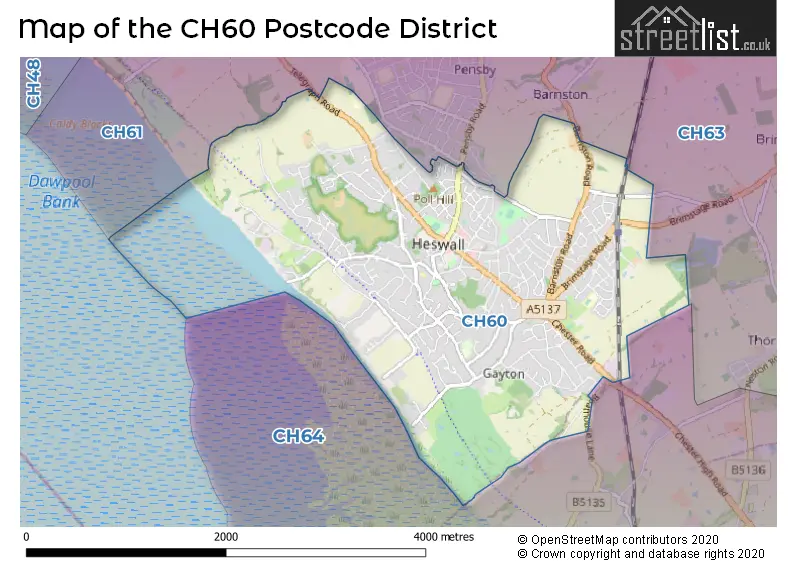
The largest settlements in the CH60 postal code are WIRRAL and Heswall.
The postcode area has a boundary with Dee Estuary.
The CH60 Postcode shares a border with CH64 (NESTON, Little Neston, Willaston) and CH61 (WIRRAL, Heswall, Thingwall).
The primary settlement in the CH60 postcode district is Heswall, located in the county of Merseyside within the post town of Wirral.
For the district CH60, we have data on 10 postcode sectors. Here's a breakdown: The sector CH60 0, covers Wirral and Heswall in Merseyside. The sector CH60 1, covers Wirral and Heswall in Merseyside. The sector CH60 2, covers Wirral and Heswall in Merseyside. The sector CH60 3, covers Wirral and Heswall in Merseyside. The sector CH60 4, covers Wirral and Heswall in Merseyside. The sector CH60 5, covers Wirral and Heswall in Merseyside. The sector CH60 6, covers Wirral and Heswall in Merseyside. The sector CH60 7, covers Heswall and Wirral in Merseyside. The sector CH60 8, covers Wirral and Heswall in Merseyside. The sector CH60 9, covers Wirral and Heswall in Merseyside.


Map of the CH60 Postcode District
Explore the CH60 postcode district by using our free interactive map.
When it comes to local government, postal geography often disregards political borders. However, for a breakdown in the CH60 District: the district mostly encompasses the Wirral District (B) area with a total of 460 postcodes.
Weather Forecast for CH60
Press Button to Show Forecast for Heswall
| Time Period | Icon | Description | Temperature | Rain Probability | Wind |
|---|---|---|---|---|---|
| 09:00 to 12:00 | Cloudy | 8.0°C (feels like 5.0°C) | 6.00% | E 9 mph | |
| 12:00 to 15:00 | Cloudy | 9.0°C (feels like 7.0°C) | 11.00% | E 7 mph | |
| 15:00 to 18:00 | Light rain | 9.0°C (feels like 7.0°C) | 50.00% | ENE 7 mph | |
| 18:00 to 21:00 | Light rain | 8.0°C (feels like 6.0°C) | 45.00% | NE 9 mph | |
| 21:00 to 00:00 | Cloudy | 8.0°C (feels like 5.0°C) | 5.00% | NE 9 mph |
Press Button to Show Forecast for Heswall
| Time Period | Icon | Description | Temperature | Rain Probability | Wind |
|---|---|---|---|---|---|
| 00:00 to 03:00 | Cloudy | 6.0°C (feels like 4.0°C) | 4.00% | NE 7 mph | |
| 03:00 to 06:00 | Cloudy | 5.0°C (feels like 2.0°C) | 4.00% | NNE 9 mph | |
| 06:00 to 09:00 | Cloudy | 6.0°C (feels like 3.0°C) | 8.00% | N 9 mph | |
| 09:00 to 12:00 | Cloudy | 8.0°C (feels like 5.0°C) | 9.00% | NNW 11 mph | |
| 12:00 to 15:00 | Partly cloudy (day) | 9.0°C (feels like 6.0°C) | 8.00% | NW 13 mph | |
| 15:00 to 18:00 | Partly cloudy (day) | 10.0°C (feels like 7.0°C) | 7.00% | WNW 13 mph | |
| 18:00 to 21:00 | Sunny day | 10.0°C (feels like 7.0°C) | 2.00% | W 11 mph | |
| 21:00 to 00:00 | Clear night | 8.0°C (feels like 5.0°C) | 1.00% | SW 11 mph |
Press Button to Show Forecast for Heswall
| Time Period | Icon | Description | Temperature | Rain Probability | Wind |
|---|---|---|---|---|---|
| 00:00 to 03:00 | Partly cloudy (night) | 7.0°C (feels like 4.0°C) | 1.00% | SSW 9 mph | |
| 03:00 to 06:00 | Cloudy | 6.0°C (feels like 4.0°C) | 6.00% | S 11 mph | |
| 06:00 to 09:00 | Partly cloudy (day) | 7.0°C (feels like 4.0°C) | 2.00% | SSE 11 mph | |
| 09:00 to 12:00 | Partly cloudy (day) | 11.0°C (feels like 8.0°C) | 2.00% | SSE 13 mph | |
| 12:00 to 15:00 | Cloudy | 13.0°C (feels like 9.0°C) | 8.00% | S 16 mph | |
| 15:00 to 18:00 | Cloudy | 13.0°C (feels like 10.0°C) | 10.00% | S 16 mph | |
| 18:00 to 21:00 | Cloudy | 12.0°C (feels like 10.0°C) | 9.00% | SSE 16 mph | |
| 21:00 to 00:00 | Cloudy | 10.0°C (feels like 8.0°C) | 4.00% | SSE 13 mph |
Press Button to Show Forecast for Heswall
| Time Period | Icon | Description | Temperature | Rain Probability | Wind |
|---|---|---|---|---|---|
| 00:00 to 03:00 | Partly cloudy (night) | 9.0°C (feels like 6.0°C) | 3.00% | SSE 13 mph | |
| 03:00 to 06:00 | Partly cloudy (night) | 8.0°C (feels like 5.0°C) | 4.00% | SE 11 mph | |
| 06:00 to 09:00 | Cloudy | 8.0°C (feels like 5.0°C) | 6.00% | SE 11 mph | |
| 09:00 to 12:00 | Partly cloudy (day) | 11.0°C (feels like 9.0°C) | 4.00% | SE 13 mph | |
| 12:00 to 15:00 | Partly cloudy (day) | 14.0°C (feels like 11.0°C) | 7.00% | SE 16 mph | |
| 15:00 to 18:00 | Cloudy | 15.0°C (feels like 12.0°C) | 12.00% | SE 13 mph | |
| 18:00 to 21:00 | Partly cloudy (day) | 14.0°C (feels like 12.0°C) | 5.00% | SE 11 mph | |
| 21:00 to 00:00 | Cloudy | 12.0°C (feels like 10.0°C) | 7.00% | ESE 9 mph |
Where is the CH60 Postcode District?
The data shows that the CH60 postcode district is located in Wirral, which is a district town. It is near several other towns, including Neston, Birkenhead, Prenton, Bagillt, Flint, Holywell, and Ellesmere Port. The distance from this postcode district to London is approximately 177.62 miles.
The district is within the post town of WIRRAL.
The sector has postcodes within the nation of England.
The CH60 Postcode District is in the Wirral region of Merseyside within the North West (England).
Postcode Sectors within the CH60 District
| Postcode Sector | Delivery Office |
|---|---|
| CH60 0 | Heswall Delivery Office |
| CH60 1 | Heswall Delivery Office |
| CH60 2 | Heswall Delivery Office |
| CH60 3 | Heswall Delivery Office |
| CH60 4 | Heswall Delivery Office |
| CH60 5 | Heswall Delivery Office |
| CH60 6 | Heswall Delivery Office |
| CH60 7 | Heswall Delivery Office |
| CH60 8 | Heswall Delivery Office |
| CH60 9 | Heswall Delivery Office |
| C | H | 6 | 0 | - | X | X | X |
| C | H | 6 | 0 | Space | Numeric | Letter | Letter |
Current Monthly Rental Prices
| # Bedrooms | Min Price | Max Price | Avg Price |
|---|---|---|---|
| 1 | £900 | £900 | £900 |
| 2 | £1,100 | £1,300 | £1,217 |
| 3 | £1,600 | £4,000 | £2,483 |
| 4 | £1,000 | £1,495 | £1,330 |
Current House Prices
| # Bedrooms | Min Price | Max Price | Avg Price |
|---|---|---|---|
| £1,350,000 | £1,350,000 | £1,350,000 | |
| 4 | £975,000 | £1,595,000 | £1,256,667 |
| 5 | £975,000 | £1,800,000 | £1,263,611 |
Estate Agents who Operate in the CH60 District
| Logo | Name | Brand Name | Address | Contact Number | Total Properties |
|---|---|---|---|---|---|
 | Heswall | Hewitt Adams Ltd | 20 Pensby Road, Heswall, CH60 7RE | 0151 453 4163 | 43 |
 | Heswall | Karl Tatler Estate Agents | 23 Pensby Road, Heswall, Wirral, CH60 7RA | 0151 453 4573 | 42 |
 | Heswall | Bradshaw Farnham & Lea | 7 Pensby Road, Heswall, CH60 7RA | 0151 453 1752 | 37 |
 | Wirral | Move Residential | 125 Telegraph Road, Heswall, CH60 0AF | 0151 453 4913 | 32 |
 | Wirral | Home Estate Agents | 42 Grange Road, West Kirby, CH48 4EF | 0151 453 0973 | 4 |
| Type of Property | 2018 Average | 2018 Sales | 2017 Average | 2017 Sales | 2016 Average | 2016 Sales | 2015 Average | 2015 Sales |
|---|---|---|---|---|---|---|---|---|
| Detached | £469,401 | 118 | £493,013 | 151 | £439,707 | 119 | £423,251 | 135 |
| Semi-Detached | £279,100 | 73 | £276,547 | 68 | £241,980 | 78 | £247,729 | 69 |
| Terraced | £207,250 | 13 | £235,296 | 19 | £182,676 | 19 | £198,779 | 7 |
| Flats | £162,373 | 42 | £198,180 | 40 | £145,901 | 38 | £133,326 | 44 |