The CH42 postcode district is a postal district located in the CH Chester postcode area with a population of 32,616 residents according to the 2021 England and Wales Census.
The area of the CH42 postcode district is 2.18 square miles which is 5.64 square kilometres or 1,392.66 acres.
Currently, the CH42 district has about 677 postcode units spread across 10 geographic postcode sectors.
Given that each sector allows for 400 unique postcode combinations, the district has a capacity of 4,000 postcodes. With 677 postcodes already in use, this leaves 3323 units available.
The CH42 postal code covers the settlement of BIRKENHEAD.
The postcode area has a boundary with Mersey.
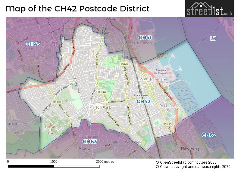
The CH42 Postcode shares a border with CH41 (BIRKENHEAD), CH62 (WIRRAL, Bromborough, Eastham), CH43 (PRENTON) and CH63 (WIRRAL, Bebington, Higher Bebington).
The primary settlement in the CH42 postcode district is Birkenhead, located in the county of Merseyside. The most significant post town in this district is also Birkenhead, located in Merseyside. Other significant settlements in the CH42 postcode district include Higher Tranmere, also located in Birkenhead.
For the district CH42, we have data on 10 postcode sectors. Here's a breakdown: The sector CH42 0, covers Birkenhead in Merseyside. The sector CH42 1, covers Birkenhead in Merseyside. The sector CH42 2, covers Birkenhead in Merseyside. The sector CH42 3, covers Birkenhead in Merseyside. The sector CH42 4, covers Birkenhead in Merseyside. The sector CH42 5, covers Birkenhead in Merseyside. The sector CH42 6, covers Birkenhead in Merseyside. The sector CH42 7, covers Birkenhead in Merseyside. The sector CH42 8, covers Birkenhead in Merseyside. The sector CH42 9, covers Birkenhead in Merseyside.

Map of the CH42 Postcode District
Explore the CH42 postcode district by using our free interactive map.
When it comes to local government, postal geography often disregards political borders. However, for a breakdown in the CH42 District: the district mostly encompasses the Wirral District (B) area with a total of 685 postcodes.
Weather Forecast for CH42
Press Button to Show Forecast for Tranmere
| Time Period | Icon | Description | Temperature | Rain Probability | Wind |
|---|---|---|---|---|---|
| 09:00 to 12:00 | Cloudy | 8.0°C (feels like 6.0°C) | 5.00% | E 9 mph | |
| 12:00 to 15:00 | Overcast | 10.0°C (feels like 8.0°C) | 10.00% | ENE 9 mph | |
| 15:00 to 18:00 | Overcast | 10.0°C (feels like 8.0°C) | 46.00% | ENE 9 mph | |
| 18:00 to 21:00 | Overcast | 9.0°C (feels like 7.0°C) | 19.00% | NE 9 mph | |
| 21:00 to 00:00 | Cloudy | 9.0°C (feels like 6.0°C) | 8.00% | NE 9 mph |
Press Button to Show Forecast for Tranmere
| Time Period | Icon | Description | Temperature | Rain Probability | Wind |
|---|---|---|---|---|---|
| 00:00 to 03:00 | Cloudy | 7.0°C (feels like 5.0°C) | 4.00% | NE 9 mph | |
| 03:00 to 06:00 | Cloudy | 6.0°C (feels like 3.0°C) | 4.00% | NNE 9 mph | |
| 06:00 to 09:00 | Cloudy | 7.0°C (feels like 4.0°C) | 8.00% | N 11 mph | |
| 09:00 to 12:00 | Cloudy | 8.0°C (feels like 6.0°C) | 11.00% | NNW 11 mph | |
| 12:00 to 15:00 | Partly cloudy (day) | 9.0°C (feels like 7.0°C) | 9.00% | NW 13 mph | |
| 15:00 to 18:00 | Sunny day | 10.0°C (feels like 8.0°C) | 8.00% | WNW 13 mph | |
| 18:00 to 21:00 | Sunny day | 10.0°C (feels like 8.0°C) | 3.00% | W 11 mph | |
| 21:00 to 00:00 | Clear night | 9.0°C (feels like 7.0°C) | 2.00% | SW 11 mph |
Press Button to Show Forecast for Tranmere
| Time Period | Icon | Description | Temperature | Rain Probability | Wind |
|---|---|---|---|---|---|
| 00:00 to 03:00 | Partly cloudy (night) | 8.0°C (feels like 5.0°C) | 1.00% | SSW 9 mph | |
| 03:00 to 06:00 | Cloudy | 7.0°C (feels like 4.0°C) | 4.00% | S 9 mph | |
| 06:00 to 09:00 | Partly cloudy (day) | 7.0°C (feels like 4.0°C) | 4.00% | SSE 13 mph | |
| 09:00 to 12:00 | Partly cloudy (day) | 10.0°C (feels like 8.0°C) | 2.00% | SSE 13 mph | |
| 12:00 to 15:00 | Cloudy | 13.0°C (feels like 10.0°C) | 7.00% | S 16 mph | |
| 15:00 to 18:00 | Cloudy | 13.0°C (feels like 10.0°C) | 9.00% | S 16 mph | |
| 18:00 to 21:00 | Cloudy | 13.0°C (feels like 10.0°C) | 8.00% | SSE 16 mph | |
| 21:00 to 00:00 | Partly cloudy (night) | 11.0°C (feels like 8.0°C) | 3.00% | SSE 13 mph |
Press Button to Show Forecast for Tranmere
| Time Period | Icon | Description | Temperature | Rain Probability | Wind |
|---|---|---|---|---|---|
| 00:00 to 03:00 | Partly cloudy (night) | 10.0°C (feels like 7.0°C) | 4.00% | SE 16 mph | |
| 03:00 to 06:00 | Cloudy | 9.0°C (feels like 6.0°C) | 6.00% | SE 13 mph | |
| 06:00 to 09:00 | Partly cloudy (day) | 9.0°C (feels like 6.0°C) | 3.00% | SE 16 mph | |
| 09:00 to 12:00 | Partly cloudy (day) | 12.0°C (feels like 9.0°C) | 4.00% | SE 16 mph | |
| 12:00 to 15:00 | Partly cloudy (day) | 14.0°C (feels like 11.0°C) | 5.00% | SE 16 mph | |
| 15:00 to 18:00 | Cloudy | 15.0°C (feels like 12.0°C) | 14.00% | SE 13 mph | |
| 18:00 to 21:00 | Partly cloudy (day) | 15.0°C (feels like 12.0°C) | 6.00% | ESE 11 mph | |
| 21:00 to 00:00 | Cloudy | 13.0°C (feels like 11.0°C) | 8.00% | ESE 11 mph |
Where is the CH42 Postcode District?
The postcode district for CH42 is located in Birkenhead. It is a town in close proximity to several nearby towns, including Prenton to the North West, Wirral to the West, Wallasey to the North, Neston to the South, Liverpool to the North East, Ellesmere Port to the South East, Bagillt to the South West, and Prescot to the East. Additionally, the distance to the center of London from this postcode district is approximately 177.68 miles.
The district is within the post town of BIRKENHEAD.
The sector has postcodes within the nation of England.
The CH42 Postcode District is in the Wirral region of Merseyside within the North West (England).
Postcode Sectors within the CH42 District
| Postcode Sector | Delivery Office |
|---|---|
| CH42 0 | Birkenhead Delivery Office |
| CH42 1 | Birkenhead Delivery Office |
| CH42 2 | Birkenhead Delivery Office |
| CH42 3 | Birkenhead Delivery Office |
| CH42 4 | Birkenhead Delivery Office |
| CH42 5 | Birkenhead Delivery Office |
| CH42 6 | Birkenhead Delivery Office |
| CH42 7 | Birkenhead Delivery Office |
| CH42 8 | Birkenhead Delivery Office |
| CH42 9 | Birkenhead Delivery Office |
| C | H | 4 | 2 | - | X | X | X |
| C | H | 4 | 2 | Space | Numeric | Letter | Letter |
Current Monthly Rental Prices
| # Bedrooms | Min Price | Max Price | Avg Price |
|---|---|---|---|
| 1 | £390 | £711 | £544 |
| 2 | £550 | £750 | £657 |
| 3 | £650 | £795 | £723 |
Current House Prices
| # Bedrooms | Min Price | Max Price | Avg Price |
|---|---|---|---|
| £375,000 | £375,000 | £375,000 | |
| 3 | £400,000 | £750,000 | £558,333 |
| 4 | £375,000 | £575,000 | £417,990 |
| 5 | £350,000 | £849,950 | £508,327 |
| 6 | £360,000 | £975,000 | £548,750 |
| 7 | £499,995 | £499,995 | £499,995 |
| 8 | £450,000 | £725,000 | £587,500 |
Estate Agents who Operate in the CH42 District
| Logo | Name | Brand Name | Address | Contact Number | Total Properties |
|---|---|---|---|---|---|
 | Prenton | Karl Tatler Estate Agents | 347 Woodchurch Road, Prenton, CH42 8PE | 0151 453 9305 | 31 |
 | Prenton | Jones & Chapman | 349 Woodchurch Road, Prenton, CH42 8PE | 0151 453 2680 | 23 |
 | Wirral | Bradshaw Farnham & Lea | 357 Woodchurch Road Prenton CH42 8PE | 0151 453 2427 | 20 |
 | Bebington | Lesley Hooks Estate Agents | 6 Church Road, Bebington, CH63 7PH | 0151 453 7889 | 12 |
 | Prenton | Brennan Ayre O'Neill | 377 Woodchurch Road, Birkenhead, CH42 8PE | 0151 453 4459 | 11 |
| Type of Property | 2018 Average | 2018 Sales | 2017 Average | 2017 Sales | 2016 Average | 2016 Sales | 2015 Average | 2015 Sales |
|---|---|---|---|---|---|---|---|---|
| Detached | £266,595 | 45 | £219,855 | 55 | £246,591 | 49 | £359,706 | 17 |
| Semi-Detached | £140,599 | 182 | £142,641 | 186 | £137,602 | 152 | £137,375 | 125 |
| Terraced | £87,650 | 308 | £85,716 | 251 | £81,696 | 249 | £80,252 | 223 |
| Flats | £77,092 | 33 | £76,144 | 37 | £69,314 | 38 | £75,279 | 53 |