The CH42 0 postcode sector is within the county of Merseyside.
Did you know? According to the 2021 Census, the CH42 0 postcode sector is home to a bustling 2,956 residents!
Given that each sector allows for 400 unique postcode combinations. Letters C, I, K, M, O and V are not allowed in the last two letters of a postcode. With 72 postcodes already in use, this leaves 328 units available.
The CH42 0 postal code covers the settlement of BIRKENHEAD.
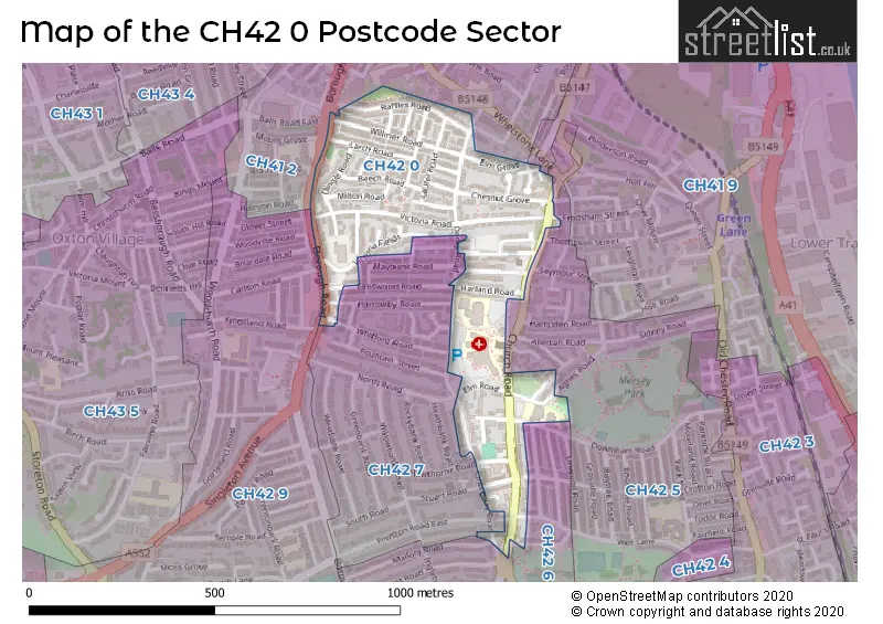
The CH42 0 Postcode shares a border with CH42 5 (BIRKENHEAD), CH41 2 (BIRKENHEAD), CH41 9 (BIRKENHEAD), CH42 6 (BIRKENHEAD), CH42 7 (BIRKENHEAD) and CH42 9 (BIRKENHEAD).
The sector is within the post town of BIRKENHEAD.
CH42 0 is a postcode sector within the CH42 postcode district which is within the CH Chester postcode area.
The Royal Mail delivery office for the CH42 0 postal sector is the Birkenhead Delivery Office.
The area of the CH42 0 postcode sector is 0.14 square miles which is 0.37 square kilometres or 90.38 square acres.

Map of the CH42 0 Postcode Sector
Explore the CH42 0 postcode sector by using our free interactive map.
| C | H | 4 | 2 | - | 0 | X | X |
| C | H | 4 | 2 | Space | 0 | Letter | Letter |
Official List of Streets
BIRKENHEAD (41 Streets)
Unofficial Streets or Alternative Spellings
BIRKENHEAD
AGNES ROAD ASPENDALE ROAD BRATTAN ROAD CARLTON ROAD DOWNHAM ROAD ELMSWOOD ROAD FRODSHAM STREET HARROWBY ROAD HAWTHORNE ROAD MALLORY ROAD MARQUIS STREET PRENTON ROAD EAST STUART ROAD TOWN ROAD VICTORIA PARK ROAD WELL LANE WELLINGTON TERRACE WHITFORD ROAD BALLS ROAD EAST ROSE PLACE ST CATHERINES GARDENS TOWER ROADSchools and Places of Education Within the CH42 0 Postcode Sector
Mersey Park Primary School
Community school
Elm Road, Wirral, Merseyside, CH42 0PH
Head: Mrs Margaret Thomas
Ofsted Rating: Outstanding
Inspection: 2019-03-14 (1886 days ago)
Website: Visit Mersey Park Primary School Website
Phone: 01516478197
Number of Pupils: 463
House Prices in the CH42 0 Postcode Sector
| Type of Property | 2018 Average | 2018 Sales | 2017 Average | 2017 Sales | 2016 Average | 2016 Sales | 2015 Average | 2015 Sales |
|---|---|---|---|---|---|---|---|---|
| Detached | £145,000 | 1 | £125,000 | 3 | £88,000 | 1 | £138,750 | 2 |
| Semi-Detached | £101,968 | 16 | £95,480 | 26 | £99,136 | 18 | £86,364 | 11 |
| Terraced | £68,189 | 29 | £65,233 | 15 | £68,250 | 19 | £71,970 | 23 |
| Flats | £85,000 | 1 | £57,500 | 2 | £0 | 0 | £0 | 0 |
Important Postcodes CH42 0 in the Postcode Sector
CH42 0LQ is the postcode for STEIN CENTRE, St. Catherines Hospital, St. Catherines Health Centre, Church Road, Wirral PCT, St. Catherines Hospital, Cheshire and Wirral Partnership NHS Foundation Trust, St Catherines Hospital, D-H BLOCK, St. Catherines Hospital, ST CATHERINES HEALTH CENTRE, CHURCH ROAD, and N BLOCK, St. Catherines Hospital
CH42 0PH is the postcode for Mersey Park Primary School, 40 Elm Road
| The CH42 0 Sector is within these Local Authorities |
|
|---|---|
| The CH42 0 Sector is within these Counties |
|
| The CH42 0 Sector is within these Water Company Areas |
|