The CH42 8 postcode sector is within the county of Merseyside.
Did you know? According to the 2021 Census, the CH42 8 postcode sector is home to a bustling 2,420 residents!
Given that each sector allows for 400 unique postcode combinations. Letters C, I, K, M, O and V are not allowed in the last two letters of a postcode. With 67 postcodes already in use, this leaves 333 units available.
The CH42 8 postal code covers the settlement of BIRKENHEAD.
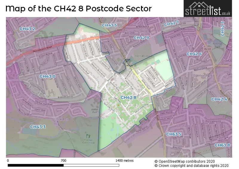
The CH42 8 Postcode shares a border with CH43 5 (PRENTON), CH42 6 (BIRKENHEAD), CH42 9 (BIRKENHEAD), CH43 0 (PRENTON), CH43 2 (PRENTON), CH43 3 (PRENTON, North Cheshire Trading Estate) and CH63 5 (WIRRAL, Bebington, Higher Bebington).
The sector is within the post town of BIRKENHEAD.
CH42 8 is a postcode sector within the CH42 postcode district which is within the CH Chester postcode area.
The Royal Mail delivery office for the CH42 8 postal sector is the Birkenhead Delivery Office.
The area of the CH42 8 postcode sector is 0.38 square miles which is 0.97 square kilometres or 240.29 square acres.

Map of the CH42 8 Postcode Sector
Explore the CH42 8 postcode sector by using our free interactive map.
| C | H | 4 | 2 | - | 8 | X | X |
| C | H | 4 | 2 | Space | 8 | Letter | Letter |
Official List of Streets
BIRKENHEAD (28 Streets)
Unofficial Streets or Alternative Spellings
BIRKENHEAD
BRECON ROAD CHEVIOT ROAD CHILTERN ROAD ELM ROAD NORTHBebington
MOUNT ROAD DUCK POND LANE MOUNT WOOD ROADBIRKENHEAD,
STORETON ROAD WATERPARK ROADPRENTON
CUMBERLAND AVENUE GLENAVON PARKUpton
WOODCHURCH ROADWeather Forecast for CH42 8
Press Button to Show Forecast for Prenton
| Time Period | Icon | Description | Temperature | Rain Probability | Wind |
|---|---|---|---|---|---|
| 06:00 to 09:00 | Partly cloudy (day) | 5.0°C (feels like 3.0°C) | 2.00% | E 7 mph | |
| 09:00 to 12:00 | Partly cloudy (day) | 7.0°C (feels like 5.0°C) | 2.00% | E 7 mph | |
| 12:00 to 15:00 | Overcast | 9.0°C (feels like 7.0°C) | 9.00% | ENE 7 mph | |
| 15:00 to 18:00 | Cloudy | 10.0°C (feels like 8.0°C) | 7.00% | ENE 7 mph | |
| 18:00 to 21:00 | Cloudy | 9.0°C (feels like 8.0°C) | 9.00% | NNE 9 mph | |
| 21:00 to 00:00 | Cloudy | 8.0°C (feels like 6.0°C) | 11.00% | ENE 9 mph |
Press Button to Show Forecast for Prenton
| Time Period | Icon | Description | Temperature | Rain Probability | Wind |
|---|---|---|---|---|---|
| 00:00 to 03:00 | Cloudy | 7.0°C (feels like 4.0°C) | 10.00% | E 9 mph | |
| 03:00 to 06:00 | Cloudy | 6.0°C (feels like 3.0°C) | 10.00% | ESE 9 mph | |
| 06:00 to 09:00 | Cloudy | 6.0°C (feels like 3.0°C) | 8.00% | E 9 mph | |
| 09:00 to 12:00 | Cloudy | 8.0°C (feels like 5.0°C) | 8.00% | E 9 mph | |
| 12:00 to 15:00 | Overcast | 10.0°C (feels like 8.0°C) | 15.00% | ENE 9 mph | |
| 15:00 to 18:00 | Overcast | 10.0°C (feels like 8.0°C) | 20.00% | NE 9 mph | |
| 18:00 to 21:00 | Cloudy | 10.0°C (feels like 8.0°C) | 16.00% | NE 11 mph | |
| 21:00 to 00:00 | Cloudy | 9.0°C (feels like 6.0°C) | 16.00% | NE 11 mph |
Press Button to Show Forecast for Prenton
| Time Period | Icon | Description | Temperature | Rain Probability | Wind |
|---|---|---|---|---|---|
| 00:00 to 03:00 | Cloudy | 8.0°C (feels like 5.0°C) | 18.00% | NE 11 mph | |
| 03:00 to 06:00 | Cloudy | 8.0°C (feels like 5.0°C) | 18.00% | NE 11 mph | |
| 06:00 to 09:00 | Heavy rain | 8.0°C (feels like 5.0°C) | 68.00% | NE 11 mph | |
| 09:00 to 12:00 | Cloudy | 9.0°C (feels like 6.0°C) | 21.00% | NNE 11 mph | |
| 12:00 to 15:00 | Light rain | 10.0°C (feels like 8.0°C) | 52.00% | NNE 11 mph | |
| 15:00 to 18:00 | Heavy rain shower (day) | 11.0°C (feels like 8.0°C) | 56.00% | N 13 mph | |
| 18:00 to 21:00 | Partly cloudy (day) | 10.0°C (feels like 8.0°C) | 14.00% | N 11 mph | |
| 21:00 to 00:00 | Clear night | 9.0°C (feels like 7.0°C) | 13.00% | W 11 mph |
House Prices in the CH42 8 Postcode Sector
| Type of Property | 2018 Average | 2018 Sales | 2017 Average | 2017 Sales | 2016 Average | 2016 Sales | 2015 Average | 2015 Sales |
|---|---|---|---|---|---|---|---|---|
| Detached | £430,909 | 11 | £292,625 | 8 | £423,000 | 11 | £431,864 | 11 |
| Semi-Detached | £227,414 | 7 | £235,636 | 14 | £187,933 | 13 | £220,283 | 14 |
| Terraced | £132,777 | 11 | £112,400 | 5 | £123,000 | 3 | £119,286 | 7 |
| Flats | £101,710 | 5 | £123,800 | 5 | £121,750 | 6 | £121,329 | 12 |
| The CH42 8 Sector is within these Local Authorities |
|
|---|---|
| The CH42 8 Sector is within these Counties |
|
| The CH42 8 Sector is within these Water Company Areas |
|