The LL40 postcode district is a postal district located in the LL Llandudno postcode area with a population of 4,053 residents according to the 2021 England and Wales Census.
The area of the LL40 postcode district is 98.04 square miles which is 253.92 square kilometres or 62,745.36 acres.
Currently, the LL40 district has about 359 postcode units spread across 2 geographic postcode sectors.
Given that each sector allows for 400 unique postcode combinations, the district has a capacity of 800 postcodes. With 359 postcodes already in use, this leaves 441 units available.
The largest settlement in the LL40 postal code is DOLGELLAU followed by LLANFACHRETH, and LLANELLTYD.
The postcode area has a boundary with Cardigan Bay.
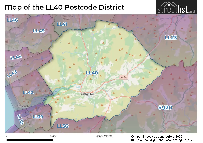
The LL40 Postcode shares a border with LL23 (Y BALA, LLANUWCHLLYN, LLANDDERFEL), LL41 (BLAENAU FFESTINIOG, TRAWSFYNYDD, LLAN FFESTINIOG), LL45 (LLANBEDR, PENTRE GWYNFRYN), LL43 (TAL Y BONT), LL36 (TYWYN, BRYNCRUG, LLANEGRYN), SY20 (MACHYNLLETH, PENNAL, CORRIS) and LL39 (ARTHOG).
The primary settlement in the LL40 postcode district is Dolgellau, located in Gwynedd, Wales. Other significant settlements in the area include Islawrdref and Penmaenpool. The county within which Dolgellau is situated is the county of Gwynedd. Dolgellau is also the main post town for this postcode district.
For the district LL40, we have data on 2 postcode sectors. Here's a breakdown: The sector LL40 1, covers Dolgellau in Gwynedd. The sector LL40 2, covers Dolgellau and Llanfachreth and Ganllwyd and Rhydymain in Gwynedd.

Map of the LL40 Postcode District
Explore the LL40 postcode district by using our free interactive map.
When it comes to local government, postal geography often disregards political borders. However, for a breakdown in the LL40 District: the district mostly encompasses the Gwynedd - Gwynedd area with a total of 358 postcodes.
Recent House Sales in LL40
| Date | Price | Address |
|---|---|---|
| 18/09/2023 | £150,000 | Cader Road, Dolgellau, LL40 1RJ |
| 15/09/2023 | £200,000 | Bryniau, Brithdir, Dolgellau, LL40 2TY |
| 14/09/2023 | £200,000 | Meyrick Street, Dolgellau, LL40 1LR |
| 11/09/2023 | £245,000 | South Street, Dolgellau, LL40 1NE |
| 08/09/2023 | £120,000 | Meyrick Street, Dolgellau, LL40 1LN |
| 31/08/2023 | £130,000 | Tal Yr Afon Buildings, Dolgellau, LL40 1BG |
| 31/08/2023 | £85,000 | Meyrick Square, Dolgellau, LL40 1LT |
| 18/08/2023 | £80,000 | Park Row, Dolgellau, LL40 1SE |
| 02/08/2023 | £120,000 | South Street, Dolgellau, LL40 1NL |
| 01/08/2023 | £249,995 | Pencefn Road, Dolgellau, LL40 2ER |
Weather Forecast for LL40
Press Button to Show Forecast for Dolgellau
| Time Period | Icon | Description | Temperature | Rain Probability | Wind |
|---|---|---|---|---|---|
| 12:00 to 15:00 | Cloudy | 10.0°C (feels like 9.0°C) | 5.00% | ENE 7 mph | |
| 15:00 to 18:00 | Cloudy | 11.0°C (feels like 10.0°C) | 5.00% | ENE 7 mph | |
| 18:00 to 21:00 | Cloudy | 9.0°C (feels like 7.0°C) | 6.00% | NE 7 mph | |
| 21:00 to 00:00 | Cloudy | 7.0°C (feels like 5.0°C) | 5.00% | ENE 4 mph |
Press Button to Show Forecast for Dolgellau
| Time Period | Icon | Description | Temperature | Rain Probability | Wind |
|---|---|---|---|---|---|
| 00:00 to 03:00 | Cloudy | 6.0°C (feels like 4.0°C) | 5.00% | ENE 7 mph | |
| 03:00 to 06:00 | Cloudy | 6.0°C (feels like 3.0°C) | 7.00% | ENE 7 mph | |
| 06:00 to 09:00 | Cloudy | 6.0°C (feels like 4.0°C) | 6.00% | ENE 7 mph | |
| 09:00 to 12:00 | Cloudy | 8.0°C (feels like 6.0°C) | 6.00% | E 9 mph | |
| 12:00 to 15:00 | Cloudy | 9.0°C (feels like 7.0°C) | 16.00% | ENE 9 mph | |
| 15:00 to 18:00 | Cloudy | 9.0°C (feels like 7.0°C) | 15.00% | ENE 9 mph | |
| 18:00 to 21:00 | Cloudy | 9.0°C (feels like 7.0°C) | 6.00% | NE 9 mph | |
| 21:00 to 00:00 | Cloudy | 7.0°C (feels like 6.0°C) | 5.00% | NE 7 mph |
Press Button to Show Forecast for Dolgellau
| Time Period | Icon | Description | Temperature | Rain Probability | Wind |
|---|---|---|---|---|---|
| 00:00 to 03:00 | Cloudy | 7.0°C (feels like 5.0°C) | 4.00% | NNE 4 mph | |
| 03:00 to 06:00 | Cloudy | 6.0°C (feels like 4.0°C) | 4.00% | NNE 4 mph | |
| 06:00 to 09:00 | Partly cloudy (day) | 6.0°C (feels like 5.0°C) | 3.00% | N 4 mph | |
| 09:00 to 12:00 | Cloudy | 9.0°C (feels like 7.0°C) | 6.00% | NNW 9 mph | |
| 12:00 to 15:00 | Cloudy | 11.0°C (feels like 9.0°C) | 7.00% | NW 11 mph | |
| 15:00 to 18:00 | Cloudy | 11.0°C (feels like 9.0°C) | 7.00% | WNW 11 mph | |
| 18:00 to 21:00 | Sunny day | 10.0°C (feels like 8.0°C) | 2.00% | WSW 11 mph | |
| 21:00 to 00:00 | Partly cloudy (night) | 9.0°C (feels like 6.0°C) | 2.00% | SSW 9 mph |
Press Button to Show Forecast for Dolgellau
| Time Period | Icon | Description | Temperature | Rain Probability | Wind |
|---|---|---|---|---|---|
| 00:00 to 03:00 | Cloudy | 9.0°C (feels like 6.0°C) | 6.00% | S 11 mph | |
| 03:00 to 06:00 | Cloudy | 9.0°C (feels like 6.0°C) | 12.00% | S 11 mph | |
| 06:00 to 09:00 | Light rain shower (day) | 9.0°C (feels like 6.0°C) | 30.00% | S 13 mph | |
| 09:00 to 12:00 | Cloudy | 11.0°C (feels like 8.0°C) | 11.00% | S 18 mph | |
| 12:00 to 15:00 | Cloudy | 12.0°C (feels like 9.0°C) | 17.00% | S 20 mph | |
| 15:00 to 18:00 | Cloudy | 13.0°C (feels like 9.0°C) | 18.00% | S 18 mph | |
| 18:00 to 21:00 | Cloudy | 12.0°C (feels like 9.0°C) | 18.00% | S 16 mph | |
| 21:00 to 00:00 | Cloudy | 11.0°C (feels like 8.0°C) | 14.00% | SSE 16 mph |
Press Button to Show Forecast for Dolgellau
| Time Period | Icon | Description | Temperature | Rain Probability | Wind |
|---|---|---|---|---|---|
| 00:00 to 03:00 | Cloudy | 10.0°C (feels like 7.0°C) | 15.00% | SSE 16 mph | |
| 03:00 to 06:00 | Cloudy | 10.0°C (feels like 7.0°C) | 15.00% | SE 13 mph | |
| 06:00 to 09:00 | Cloudy | 10.0°C (feels like 7.0°C) | 11.00% | SE 13 mph | |
| 09:00 to 12:00 | Partly cloudy (day) | 12.0°C (feels like 9.0°C) | 9.00% | SE 16 mph | |
| 12:00 to 15:00 | Partly cloudy (day) | 15.0°C (feels like 11.0°C) | 8.00% | SE 16 mph | |
| 15:00 to 18:00 | Cloudy | 15.0°C (feels like 12.0°C) | 12.00% | SE 13 mph | |
| 18:00 to 21:00 | Cloudy | 14.0°C (feels like 12.0°C) | 11.00% | SE 9 mph | |
| 21:00 to 00:00 | Clear night | 12.0°C (feels like 10.0°C) | 5.00% | E 7 mph |
Where is the LL40 Postcode District?
The postcode district LL40 is located in Dolgellau, which is a town in North Wales. Dolgellau is surrounded by several nearby towns, including Barmouth which is located to the west and is approximately 7.34 miles away, Arthog which is located to the southwest and is approximately 7.84 miles away, and Llanbedr which is located to the northwest and is approximately 9.34 miles away. In addition, Dolgellau is situated approximately 181.52 miles from the center of London.
The district is within the post town of DOLGELLAU.
The sector has postcodes within the nation of Wales.
The LL40 Postcode District is in the Gwynedd region of West Wales within the Wales.
| Postcode Sector | Delivery Office |
|---|---|
| LL40 1 | Dolgellau Delivery Office |
| LL40 2 | Dolgellau Delivery Office |
| L | L | 4 | 0 | - | X | X | X |
| L | L | 4 | 0 | Space | Numeric | Letter | Letter |
Tourist Attractions within the Postcode Area
We found 1 visitor attractions within the LL40 postcode area
| Coed y Brenin Forest Park |
|---|
| View Coed y Brenin Forest Park on Google Maps |
Current Monthly Rental Prices
| # Bedrooms | Min Price | Max Price | Avg Price |
|---|
Current House Prices
| # Bedrooms | Min Price | Max Price | Avg Price |
|---|---|---|---|
| £60,000 | £325,000 | £130,000 | |
| 1 | £95,000 | £155,000 | £116,875 |
| 2 | £130,000 | £365,000 | £196,156 |
| 3 | £149,950 | £475,000 | £253,744 |
| 4 | £145,000 | £825,000 | £383,636 |
| 5 | £169,950 | £4,000,000 | £946,128 |
| 6 | £525,000 | £525,000 | £525,000 |
| 7 | £595,000 | £595,000 | £595,000 |
| 8 | £275,000 | £675,000 | £408,333 |
| 14 | £599,995 | £599,995 | £599,995 |
Estate Agents who Operate in the LL40 District
| Logo | Name | Brand Name | Address | Contact Number | Total Properties |
|---|---|---|---|---|---|
 | Dolgellau | Walter Lloyd Jones & Co. | Bridge Street, Dolgellau, LL40 1AS | 01341 400164 | 40 |
 | Bala | RG Jones | 85 High Street, Bala, LL23 7AE | 01677 931141 | 4 |
 | Llanbedr | Monopoly Buy Sell Rent | 1A TYN CELYN Llanbedr, LL45 2HN | 01341 408145 | 3 |
 | covering Llandudno | Purplebricks | Suite 7 First Floor Cranmore Drive Shirley Solihull B90 4RZ | 020 3907 3310 | 3 |
 | Shrewsbury | Strutt & Parker | Theatre Royal, 16 Shoplatch, Shrewsbury, Shropshire SY1 1HR | 01743 298105 | 2 |
| Type of Property | 2018 Average | 2018 Sales | 2017 Average | 2017 Sales | 2016 Average | 2016 Sales | 2015 Average | 2015 Sales |
|---|---|---|---|---|---|---|---|---|
| Detached | £262,240 | 25 | £225,490 | 27 | £203,000 | 25 | £231,193 | 23 |
| Semi-Detached | £159,177 | 17 | £135,832 | 17 | £118,077 | 13 | £142,923 | 13 |
| Terraced | £139,632 | 19 | £111,688 | 28 | £108,879 | 22 | £107,737 | 19 |
| Flats | £98,500 | 3 | £0 | 0 | £81,571 | 7 | £117,900 | 5 |